 W
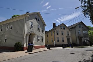
WThe Andrew Dickhaut Cottages Historic District encompasses a collection of historic worker cottages in the Smith Hill neighborhood of Providence, Rhode Island, along with the home of their builder, Andrew Dickhaut. The cottages are located at 114—141 Bath Street, 6-18 Duke Street, and the Dickhaut house is located at 377 Orms Street. The cottages are virtually identical 1-1/2 story wood frame structures, set on small lots close to the sidewalk. Those on Bath Street were built in 1882, while those on Duke Street were built in 1892. This collection represents a remarkably well-preserved collection of worker housing, a building form which is often poorly documented.
 W
WThe Blackstone Boulevard Realty Plat Historic District is a historic district roughly bounded by Blackstone Blvd., Rochambeau Ave., Holly St. and Elmgrove Ave. in Providence, Rhode Island.
 W
WThe Blackstone Boulevard–Cole Avenue–Grotto Avenue Historic District is a predominantly residential historic district roughly bounded by Blackstone Boulevard, Cole Avenue, Grotto Avenue, President and Rochambeau Avenues on the east side of Providence, Rhode Island. It encompasses one of the last areas of the city be developed residentially. Covering about 100 acres (40 ha), most of its building stock was built between about 1889 and the 1940s, with a notable building spurt taking place in the 1920s. The architecture in the area is heterogeneous, with Colonial and Georgian Revival styles predominating. The area was developed after the city built Blackstone Boulevard with the intention of developing the area into a streetcar suburb.
 W
WBlackstone Park Historic District is roughly bounded by the Seekonk River, Laurell Avenue, Blackstone Boulevard, and South Angell Street in Providence, Rhode Island within the Blackstone region of the East Side.
 W
WThe Bridgham–Arch–Wilson Streets Historic District is a predominantly residential historic district in Providence, Rhode Island. It is located southwest of downtown Providence, and was developed beginning in the 1840s as a suburban part of the city. It is roughly in the shape of a boot, roughly bounded by Cranston, Bridgham, Elmwood, and Harrison Streets. Most of the housing is architecturally reflective of the mid-19th century, with the Greek Revival, Italianate, and Second Empire styles well represented. Development in the area slowed in the late 19th and early 20th centuries, so there are only a modest number of Queen Anne, Stick style, and Colonial Revival properties. Most of the houses are either 1-1/2 or 2-1/2 story wood frame structures, and are generally set on fairly small lots. There are 175 primary buildings in the district, of which more than 150 are historically significant.
 W
WThe Broadway–Armory Historic District is a historic district encompassing a mainly residential mixed-used urban area west of downtown Providence, Rhode Island.
 W
WBurnside Park is a small park situated in downtown Providence, Rhode Island, adjacent to Kennedy Plaza. Named for Ambrose Burnside, a general in the American Civil War from Rhode Island, an equestrian statue was erected in his honor in the late 19th century, and sits in the center of the park.
 W
WThe College Hill Historic District is located in the College Hill neighborhood of Providence, Rhode Island, United States. It was designated a National Historic Landmark District on December 30, 1970. The College Hill local historic district, established in 1960, partially overlaps the national landmark district. Properties within the local historic district are regulated by the city's historic district zoning ordinance, and cannot be altered without approval from the Providence Historic District Commission.
 W
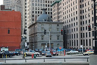
WThe Customhouse Historic District is a historic district encompassing fifteen historic buildings in downtown Providence, Rhode Island. The district is bounded by Westminster, Exchange, Dyer, Pine, and Peck Streets, and includes eight buildings associated with the important functions of the business center Providence became in the mid-to-late 19th century. It was listed on the National Register of Historic Places in 1975, and is completely contained within the Downtown Providence Historic District, listed in 1984.
 W
WDowntown is the central economic, political, and cultural district of the city of Providence, Rhode Island. It is bounded on the east by Canal Street and the Providence River, to the north by Smith Street, to the west by Interstate 95, and to the south by Henderson Street. I-95 serves as a physical barrier between the city's commercial core and neighborhoods of Federal Hill, West End, and Upper South Providence. Most of the downtown is listed on the National Register of Historic Places as the Downtown Providence Historic District.
 W
WThe Doyle Avenue Historic District is a predominantly residential historic district on the East Side of Providence, Rhode Island. It extends along Doyle Avenue from North Main Street in the west to Proctor Place. This area was developed residentially between 1860 and 1920, with an architecturally diverse collection of houses, generally set on small lots with only modest setback from the sidewalk. Land on the south side of Doyle Avenue was owned by the Dexter Commission, which managed a large tract of land bequested to the city by Ebenezer Dexter. This land was originally leased to developers. One of the first houses built in this area was the c. 1875 Thomas Collins House at 33 Doyle Avenue, a 2-1/2 story Italianate duplex.
WEdgewood Lake is a lake in the southern part of the city of Providence, Rhode Island.
 W
WThe Elmgrove Gardens Historic District is a residential historic district in northeastern Providence, Rhode Island, United States. It is bounded on the north by Rochambeau Street, on the south by Woodbury Street, on the east by Cole Street, and on the west by Morris Avenue. This area was developed most heavily between 1908 and 1948, and is a well-preserved example of an early automotive suburban residential area. Most of the houses in the district are either 1-1/2 or 2-1/2 stories in height, and are built in an architecturally diverse variety of styles. The district also includes to 18th-century farmhouses, reminders of the area's agrarian past.
 W
WThe Elmwood Historic District encompasses two large residential sections of the Elmwood neighborhood of Providence, Rhode Island. The Elmwood area was mainly farmland until the mid-19th century, when its development as a residential area began, and these two sections represents well-preserved neighborhoods developed between about 1850 and 1920. The district was listed on the National Register of Historic Places in 1980.
 W
WFields Point is a historic park in the Washington Park neighborhood of Providence, Rhode Island jutting into Narragansett Bay right near the Providence River and Route 95.
 W
WThe Freeman Plat Historic District is a residential historic district on the East Side of Providence, Rhode Island. The district is a well-preserved example of an early-20th-century planned residential area, encompassing some 50 acres (20 ha). It is roughly bounded by Sessions Street, Morris Avenue, Laurel Avenue, and Wayland Avenue, and consists of a network of generously-landscaped winding roads, laid out in consultation with the Olmsted Brothers design firm. The houses built are generally of high quality, many of them architect-designed, with architecturally diverse revival styles popular at the time. The area was developed between 1916 and 1929 by John Freeman, who owned a country estate in the area, and sought a way to develop the largely swampy tract.
 W
WGreen Jacket Shoal is a 33-acre (13 ha) shoal and ship graveyard in Providence River, between the cities of East Providence and Providence, Rhode Island, United States. It contains a large amount of debris from a century of abandoned and wrecked ships, destroyed docks, pilings, and other remnants of the area's industrial past. India Point, on the Providence side, was the city's first port, which remained active from 1680 until the Great Depression in the early 20th century. Bold Point, on the East Providence side, was home to a dry dock and other maritime businesses.
 W
WThe Hope–Power–Cooke Streets Historic District is a residential historic district on the East Side of Providence, Rhode Island. Located east of Brown University, the area is compact area developed in the mid-to-late 19th century as a residential district, with a cross-section of architectural styles from the early 19th to the early 20th century. The district is bounded on the north by Angell Street, on the east by Governor Street, on the south by Power Street, and on the west by Hope Street. Cooke Street is the main thorough fare running through the center of the district, which is six blocks long and two wide. The district abuts the Stimson Avenue Historic District, which lies immediately to its west.
 W
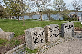
WIndia Point Park is a park in the Fox Point neighborhood of Providence, Rhode Island at the confluence of the Seekonk River and Providence River. The park takes its name from the maritime activity connecting Providence with the East and West Indies. The East Bay Bike Path begins at the eastern end of the park, and crosses over the Washington Bridge before heading to Watchemoket Square in East Providence and continuing on to Bristol and the Mount Hope Bridge. The park is also a part of the Washington–Rochambeau Revolutionary Route.
 W
WThe Moshassuck River is a river in the U.S. state of Rhode Island. It flows 8.9 miles (14.3 km) from the town of Lincoln to the city of Providence. There are six dams along the river's length.
 W
WThe city of Providence, Rhode Island has 25 official neighborhoods.
 W
WThe Norwood Avenue Historic District is a residential historic district in Cranston and Providence, Rhode Island. It includes all of the properties along Norwood Avenue between Broad Street in Cranston and Green Boulevard in Providence. The street is lined with houses built for the most part between 1890 and 1930, which are stylistically Queen Anne and Colonial Revival in character.
 W
WThe Oakland Avenue Historic District is a residential historic district in the Smith Hill neighborhood of Providence, Rhode Island, USA. The area is a densely built stretch of Oakland and Pembroke Avenues, extending from Eaton Street in the north to about half-way between Chad Brown Street and Smith Street in the south. Only buildings on the east side of Pembroke are included, while both sides of Oakland Avenue are, as are a few properties on adjacent roads. All but two of the 110 buildings in the district are residential, and are set on small lots of similar size. The houses are almost all multi-unit, housing either two or three units, and were built in between 1890 and 1930. The district represents a dense and well-preserved collection of this type of housing in the city, and was one of its last "inner city" areas to be developed.
 W
WOlney Street–Alumni Avenue Historic District is a residential historic district in northeastern Providence, Rhode Island. Located just north of the Moses Brown School campus, this is an enclave of 53 tasteful yet conservative houses built between about 1880 and 1938. It includes houses along Olney Street and Alumni Avenue between Hope and Arlington Streets, and includes a few houses on adjacent streets. Most of these houses are uniformly set back from the street, even though there was no zoning requiring that at the time, and are of brick and/or wood construction. They are stylistically heterogeneous, with Queen Anne and the Colonial Revival predominating.
 W
WThe Parkis–Comstock Historic District is a residential historic district in the Elmwood neighborhood of Providence, Rhode Island. It includes all of the properties on Parkis Avenue and a number of properties on the western end of Comstock Street and Harvard Avenue, just across Broad Street from Parkis. The houses are set on relatively uniform large lots, generally set close to the street, and represent a fine collection of Late Victorian upper-class housing. Most of the houses were built between the 1860s and the 1910s. The first house to be built on Parkis Avenue was the c. 1869 Louis Comstock House at number 47; it has fine Second Empire styling, with corner quoining and a bracketed mansard roof.
 W
WThe Pekin Street Historic District is a residential historic district bounded by Pekin and Candace Streets, Douglas and Chalkstone Avenues in Providence, Rhode Island. It is a well-preserved densely built neighborhood of working class housing, built almost entirely between 1870 and 1910. Most of the structures are either two or three-family units, with two-families predominating among the older buildings and triple-deckers among the later ones. The buildings are generally set on narrow lots with small yards. The district's main north-south roads are Pekin and Candace Streets, which are joined by a number of cross streets.
 W
WThe Pine Street Historic District is a residential historic district on the south side of Providence, Rhode Island. It extends along Pine Street between Seekell and Myrtle Streets, and includes properties east of Pine and north of Pearl Street on Friendship, Prince, Maple, and Stewart Streets. The district represents an enclave of 19th-century residential housing in an area otherwise affected by urban renewal activities.
WThe Power Street–Cooke Street Historic District is a residential historic district on the East Side of Providence, Rhode Island. Located east of Brown University, the area is compact area developed in the mid-to-late 19th century as a residential district, with a cross-section of architectural styles from the early 19th to the early 20th century. The district is bounded on the north by Angell Street, on the east by Governor Street, on the south by Power Street, and on the west by Hope Street. Cooke Street is the main thorough fare running through the center of the district, which is six blocks long and two wide. The district abuts the Stimson Avenue Historic District, which lies immediately to its west.
 W
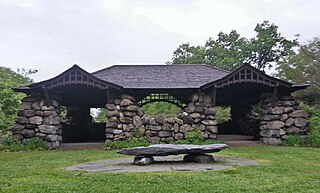
WProspect Terrace Park is a park located on Congdon Street in the College Hill neighborhood of Providence, Rhode Island. The park was founded in 1869, on land that was given to the city by residents of the neighborhood. The park is known as "The Jewel of the City" for its dramatic elevated view of Providence's "downcity."
 W
WThe Providence River is a tidal river in the U.S. state of Rhode Island. It flows approximately 8 miles (13 km). There are no dams along the river's length, although the Fox Point Hurricane Barrier is located south of downtown to protect the city of Providence from damaging tidal floods.
 W
WRhodes Street Historic District is a residential historic district encompassing one block of Rhodes Street in southern Providence, Rhode Island, along with the dead-end Janes and Alphonso Streets. This area has a well-preserved collection of stylish 19th century houses, built roughly between 1850 and 1895. South Providence did not see much residential development until after industry began moving into the area. These houses were built on land that was originally part of the Rhodes family farm, and were built for managers of nearby industrial facilities. Architecturally the houses represent a cross-section of styles popular in the period.
 W
WThe Roger Williams National Memorial is a landscaped urban park located on a common lot of the original settlement of Providence, Rhode Island, established by Roger Williams in 1636, bounded by North Main, Canal, and Smith Streets, and Park Row. The memorial commemorates the life of the co-founder of the Colony of Rhode Island and Providence Plantations and a champion of the ideal of religious freedom. Williams was banished from the Massachusetts Bay Colony for his beliefs, and he founded this colony as a place where all could come to worship as their conscience dictated without interference from the state. This park is the 20th smallest National Park System unit in the nation.
 W
WRoger Williams Park is an elaborately landscaped 427-acre (173 ha) city park in Providence, Rhode Island and a historic district listed on the National Register of Historic Places. It is named after Roger Williams, the founder of the city of Providence and the primary founder of the state of Rhode Island.
WRoosevelt Lake is a lake in the southern part of the city of Providence, Rhode Island, USA.
 W
WThe Seekonk River is a tidal extension of the Providence River in the U.S. state of Rhode Island. It flows approximately 8 km (5 mi). Most historical scholars agree that the name is derived from two Native American words, sucki and honc. The river is home to the Brown University men's rowing team, India Point Park, Blackstone Park, Crook Point Bascule Bridge, Narragansett Boat Club, Swan Point Cemetery, and the Bucklin Point waste-water treatment facility. The River is listed by RIDEM as an impaired waterway.
 W
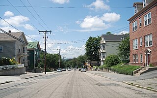
WThe Smith Hill Historic District is a historic district located in northwestern Providence, Rhode Island, just west of the Rhode Island State House and Interstate 95. It includes 57-65 Brownell Street, 73-114 Holden Street, 23-80 Jewett Street, 189-240 Smith Street and 10-18 W. Park Street. This area is a densely built residential section, an isolated remnant of what was once a larger residential area. Most of the 41 properties are residential units built between 1870 and 1930, and are typically 2-1/2 or 3-1/2 stories in height. They are set on lot sizes ranging generally from 3000 to 5000 square feet, and are set close to the sidewalk. The only major non-residential buildings are St. Patrick's School at 244 Smith Street and "The Mohican" at 185-189 Smith Street; the latter is an Art Deco brick and concrete commercial block two stories in height.
 W
WStarvegoat Island was a small island in the Providence River, Providence, Rhode Island. The island also appears as "Sunshine Island" on the 1927 North American datum map produced by the US Army Corps of Engineers 30th Battalion. The island was the southeasternmost point in the city of Providence. During the 19th and early 20th centuries, it was known for its oystering. It was located off the coast of Fields Point until the passage between them was filled in during the 1950s and 1960s when the area was used as a land fill. The approximate location of the island is now an educational center for Save the Bay, and one of its features is the re-creation of a natural coastal buffer zone.
 W
WThe State Home and School for Dependent and Neglected Children was the first state home for needy children in the state of Rhode Island. It was located on a campus in what was originally rural western Providence, on a former gentleman's farm. The school was established in 1884 and operated until 1979, when its remaining functions were taken over by other state organizations. Most of its surviving grounds and buildings are now on the Rhode Island College East Campus, and have been listed as a historic district on the National Register of Historic Places.
WThe Stimson Avenue Historic District is a residential historic district on the east side of Providence, Rhode Island. It includes all of Stimson Avenue and Diman Place, as well as adjacent properties on Angell Street on the south and Hope Street on the west, forming a relatively compact rectangular area. This area was developed roughly between 1880 and 1900, and features a collection of high-quality Queen Anne and Colonial Revival houses, with a few earlier Italianate houses at its edges. Among the finest is 19 Stimson Avenue, built in 1890 to a design by Stone, Carpenter & Willson; it is stylistically transitional between Queen Anne and Colonial Revival, featuring elaborate woodwork and a large number of exterior surface finishes, in a predominantly symmetrical Colonial Revival form. The only non-residential structure is the 1893 brick Central Congregational Church at 296 Angell Street.
 W
WThe Summit Historic District is a residential historic district in northeastern Providence, Rhode Island. It is bounded on the east by Summit Avenue, the south by Rochambeau Avenue, the west by Camp Street, and the north by Memorial Road and Creston Way. It contains 155 houses, most of which were built between 1918 and 1938. The area was annexed by Providence in 1874 and platted out of farmland in 1916, and represents a typical suburban development of the period. Most of these houses are set on lots between 4,500 and 5,500 square feet in size, although there are some double lots. Single family homes predominate, with a number of two- and three-family houses present. Architecturally the houses are heterogeneous, with styles ranging from the late Queen Anne to the Colonial and Tudor Revivals. The only significant non-residential structure in the district is Temple Beth Shalom at 120 Rochambeau Avenue, which does not contribute to its significance.
 W
WThayer Street in Providence, Rhode Island is a popular destination for students of the area's nearby schools of Brown University, Moses Brown School, Hope High School, Wheeler School, RISD, Providence College, Johnson & Wales University, and Rhode Island College.
 W
WThe Trinity Square Historic District is a historic district in the Elmwood neighborhood of Providence, Rhode Island. It includes four properties on the south and west side of Trinity Square, the triangular junction of Elmwood Avenue and Broad Street. The visual focal points of the district are the Grace Church Cemetery, which is located south of the square, and the Trinity United Methodist Church, an imposing Gothic Revival structure built in the mid-1860s to a design by Clifton A. Hall. North of the church stands the Clifton Hall Duplex, designed and occupied by Hall, and the James Potter House, an elaborate Queen Anne mansion built c. 1889 and designed by Stone, Carpenter & Willson.
 W
WThe Wanskuck Historic District is a historic district in the city of Providence, Rhode Island encompassing a mill village with more than two hundred years of history. As early as the mid-18th century, mills stood on the West River in northern Providence, a development which continued with the rise of industrialization in the 19th century. The mill village of Wanskuck is organized around three thoroughfares: Branch Street, Veazie Street, and Woodward Road, and is roughly bounded on the east by Louisquisset Pike and to the northwest by the city line with North Providence. The West River runs through the district, with its banks lined by two late-19th-century mill complexes. The village area includes a variety of examples of mill worker housing, from duplexes to rowhouses, as well as two church complexes and a community hall built in 1884 by the Wanskuck Company.
 W
WWaterplace Park is an urban park situated along the Woonasquatucket River in downtown Providence, Rhode Island at the original site of the Great Salt Cove. Finished in 1994, Waterplace Park is connected to 3/4 mile of cobblestone-paved pedestrian walkways along the waterfront known as Riverwalk. Venice-styled Pedestrian bridges cross the river. Most of Riverwalk is below street level and automotive traffic. Waterplace Park and Riverwalk together are host to Providence's popular summertime Waterfire events, a series of bonfires lit on the river accompanied by classical and world music.
 W
WThe Wayland Historic District is a predominantly residential historic district on the east side of Providence, Rhode Island. It is a large area, covering about 122 acres (49 ha), bounded roughly on the north by Everett and Laurel Avenues, on the east by Blackstone Boulevard and Butler Avenue, on the west by Arlington Avenue, and on the south by Angell and South Angell Streets. This area, which was in the 19th century part of the Moses Brown farm, was platted for development in 1891, with most of the construction taking place in the early decades of the 20th century. Most of the residential properties in the district are single-family houses, typically built in revival styles popular at the time. They are set on similarly-sized lots with fairly uniform setbacks, and were typically built without garages. There are a number of two-family houses, and a small number of apartment buildings, most of which are found on the arterial roads of the area. There are several religious buildings, including several churches; the most architecturally distinctive religious building is the Jewish Temple Beth El, built 1951–54.
 W
WThe Wesleyan Avenue Historic District is a residential historic district in the Elmwood section of Providence, Rhode Island. It includes 25 houses, on a one-block section of Wesleyan Avenue between Taylor and Broad Streets, with a few of them on the two end streets. They are large two-plus story wood frame houses, set on modest lot, all of which were built between 1875 and 1900. The houses are in a diversity of styles popular at that time, including Second Empire, Stick style, and Queen Anne. The district includes what is one of Providence's finest Stick style houses, the Samuel Darling House at 53 Wesleyan Avenue. It was built in 1885, and displays a wealth of applied wood work, decorative shingling, and intricately carved porch details.
 W
WThe West River is a river in the U.S. state of Rhode Island. It flows approximately 7.6 miles (12.2 km) and is the only named tributary of the Moshassuck River. It has a history of providing water to textile mills during the Industrial Revolution as evidenced by the 7 dams along the river's length.
 W
WWestminster Street Historic District is a commercial historic district consisting of six buildings along the north side of Westminster Street in Providence, Rhode Island, a short way west of Interstate 95. Three of the buildings are located just west of Dean Street, while the other three are just to its east. Five of the six buildings were constructed between 1870 and 1900, and the sixth in 1933. These five, the most prominent of which is the Burrows Block are uniformly built of brick and masonry, while the Chiapinelli Block, at the eastern end of the district, is an Art Deco office building with a concrete main facade and brick sidewalls.
 W
WWickenden Street in Providence, Rhode Island is a popular destination for students of the area's colleges and schools. The street is surrounded by schools and universities on the East Side of Providence's College Hill, including Brown University, RISD, Moses Brown School, & The Wheeler School.
 W
WThe Woonasquatucket River is a river in the U.S. state of Rhode Island. It flows approximately 15.8 miles (25.4 km) and drains a watershed of 130 km2 (50 sq mi).