 W
WThe 1948 Donora smog killed 20 people and caused respiratory problems for 7,000 people of the 14,000 population of Donora, Pennsylvania, a mill town on the Monongahela River 24 miles (39 km) southeast of Pittsburgh. The event is commemorated by the Donora Smog Museum.
 W
WEight Mile is an unincorporated community in Mobile County, Alabama, United States. The community is named for its distance from the city of Mobile. Part of it was annexed in the mid-20th century by the city of Prichard, Alabama.
 W
WIn February 2014, an Eden, North Carolina facility owned by Duke Energy spilled 39,000 tons of coal ash into the Dan River. The company later pled guilty to criminal negligence in their handling of coal ash at Eden and elsewhere and paid substantial fines. The U.S. Environmental Protection Agency (EPA) has since been responsible for overseeing cleanup of the waste. EPA and Duke Energy signed an administrative order for the site cleanup.
 W
WThe 2016 Southeastern United States gasoline shortage was an phenomenon caused by the 2016 Colonial Pipeline Leak and the resulting panic buying in which many gas stations across six states have entirely run out of gasoline, causing price hikes, halts of services, and several declarations of states of emergency.
WThe Alabama Plating Company Superfund site is a former industrial site in Vincent, Alabama. The site covers 6 acres and was used by the Alabama Plating Company as an electroplating facility between 1956-1986. The facility caused contamination of the ground water with hazardous waste containing heavy metals. After assessment by the United States Environmental Protection Agency (EPA) it was added to the National Priorities List in September 2012 for remedial action. The site cleanup is directed by the federal Superfund program.
 W
WThe Alamo Canal was a 14 mi (23 km) long waterway that connected the Colorado River to the head of the Alamo River. The canal was constructed to provide irrigation to the Imperial Valley. A small portion of the canal was located in the United States but the majority of the canal was located in Mexico. The Alamo Canal is also known as the Imperial Canal.
WThe American Brass Superfund site is a former industrial site, located in Henry County, Alabama. American Brass Inc. (ABI) operated a brass smelter and foundry facility on the site between 1978-1992. Prior to its closure in December 1992, the company had been cited by the United States Environmental Protection Agency (EPA), and the Alabama Department of Environmental Management, (ADEM), on several occasions for Resource Conservation and Recovery Act (RCRA) violations, arising from its waste and hazardous waste disposal processes. Site surveys, conducted by ADEM after ABI ceased operations, revealed stockpiles of 150,000 tons of contaminated waste, and extensive soil and groundwater contamination.
 W
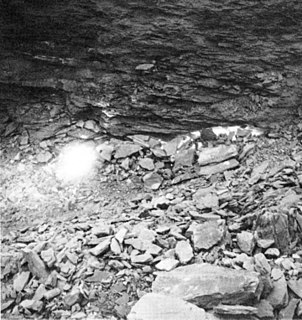
WThe Berkeley Pit is a former open pit copper mine located in Butte, Montana, United States. It is 1 mi (1,600 m) long by 1⁄2 mi (800 m) wide with an approximate depth of 1,780 feet (540 m). It is filled to a depth of about 900 feet (270 m) with water that is heavily acidic, about the acidity of Coca-Cola, lemon juice, or gastric acid. As a result, the pit is laden with heavy metals and dangerous chemicals that leach from the rock, including copper, arsenic, cadmium, zinc, and sulfuric acid.
 W
WThe Brio Superfund site is a former industrial location in Harris County, Texas at the intersection of Beamer Road and Dixie Farm Road, about 16 miles (26 km) southeast of downtown Houston, and adjacent to the Dixie Oil Processors Superfund site. It is a federal Superfund site, although it was deleted from the National Priorities List in December 2006. A neighboring residential subdivision called South Bend, now abandoned, was located along and north of the northern boundary of Brio North. The former South Bend neighborhood consisted of about 670 homes, an elementary school, and a Little League baseball field. Documents pertaining to the Brio Superfund site are located at the San Jacinto College South Campus Library, which houses Brio Site Repository Documents, U.S. Environmental Protection Agency (EPA) Administrative Records, and documents concerning the adjoining Dixie Oil Processors site.
 W
WThe Buffalo Creek Flood: An Act of Man is a 1975 documentary film produced by Appalshop. The film is about the Buffalo Creek Flood, an incident that occurred on February 26, 1972 when the Pittston Coal Company's coal slurry impoundment dam in Logan County, West Virginia burst four days after having been declared 'satisfactory' by a federal mine inspector. The film includes interviews with survivors, mining officials, and union representatives, along with footage of the flood itself.
 W
WCalCOFI is a multi-agency partnership formed in 1949 to investigate the collapse of the sardine population off California. The organization's members are from NOAA Fisheries Service, Scripps Institution of Oceanography, and California Department of Fish and Wildlife. The scope of this research has evolved into the study of marine ecosystems off California and the management of its fisheries resources. In 2004, the CalCOFI survey area became one of 26 LTER research sites. This time-series of oceanographic and fisheries data allows scientists to assess the human impact and effects of climate change on the coastal ocean ecosystem. CalCOFI hydrographic & biological data, publications, and web information are distributed for use without restriction under the terms of the GNU Free Documentation License.
 W
WThe Centralia mine fire is a coal-seam fire that has been burning underneath the borough of Centralia, Pennsylvania, United States, since at least May 27, 1962. Its original cause is still a matter of debate. It is burning in underground coal mines at depths of up to 300 feet (90 m) over an 8-mile (13 km) stretch of 3,700 acres (15 km2). At its current rate, it could continue to burn for over 250 years. It has caused most of the town to be abandoned: the population dwindled from around 1,500 at the time the fire started to 5 in 2017, and most of the buildings have been razed.
 W
WCentralia is a borough and near-ghost town in Columbia County, Pennsylvania, United States. Its population has dwindled from more than 1,000 residents in 1980 to 63 by 1990, to only five in 2017—a result of the coal mine fire which has been burning beneath the borough since 1962. Centralia, which is part of the Bloomsburg–Berwick metropolitan area, is the least-populated municipality in Pennsylvania. It is completely surrounded by Conyngham Township.
 W
WThe Clark Fork, or the Clark Fork of the Columbia River, is a river in the U.S. states of Montana and Idaho, approximately 310 miles (500 km) long. The largest river by volume in Montana, it drains an extensive region of the Rocky Mountains in western Montana and northern Idaho in the watershed of the Columbia River. The river flows northwest through a long valley at the base of the Cabinet Mountains and empties into Lake Pend Oreille in the Idaho Panhandle. The Pend Oreille River in Idaho, Washington, and British Columbia, Canada which drains the lake to the Columbia in Washington, is sometimes included as part of the Clark Fork, giving it a total length of 479 miles (771 km), with a drainage area of 25,820 square miles (66,900 km2). In its upper 20 miles (32 km) in Montana near Butte, it is known as Silver Bow Creek. Interstate 90 follows much of the upper course of the river from Butte to Saint Regis. The highest point within the river's watershed is Mount Evans at 10,641 feet (3,243 m) in Deer Lodge County, Montana along the Continental Divide.
 W
WThe original World Trade Center in Lower Manhattan, New York City was destroyed during the terrorist attacks of September 11, 2001, after being struck by two hijacked commercial airliners. One World Trade Center was hit at 8:46 a.m. Eastern time and collapsed at 10:28 a.m. Two World Trade Center was hit at 9:03 a.m. and collapsed at 9:59 a.m. The resulting debris severely damaged or destroyed more than a dozen other adjacent and nearby structures, ultimately leading to the collapse of 7 World Trade Center at 5:21 p.m.
 W
WThe Dewey Loeffel Landfill is an EPA superfund site located in Rensselaer County, New York. In the 1950s and 1960s, the site was used as a disposal facility for more than 46,000 tons of industrial hazardous wastes, including solvents, waste oils, polychlorinated biphenyls (PCBs), scrap materials, sludges and solids. Some hazardous substances, including volatile organic compounds (VOCs) and PCBs, have migrated from the facility to underlying aquifers and downstream surface water bodies, resulting in contamination of groundwater, surface water, sediments and several species of fish. There is currently a ban on fish consumption in Nassau Lake and the impacted tributaries. Site investigations are underway to determine the nature and extent of the contamination and inform the development of permanent cleanup options for the site.
 W
WTimes Beach is a ghost town in St. Louis County, Missouri, United States, 17 miles (27 km) southwest of St. Louis and 2 miles (3 km) east of Eureka. Once home to more than two thousand people, the town was completely evacuated early in 1983 due to TCDD—also known as dioxin—contamination. It was the largest civilian exposure to this compound in the history of the United States.
 W
WThe Dust Bowl was a period of severe dust storms that greatly damaged the ecology and agriculture of the American and Canadian prairies during the 1930s; severe drought and a failure to apply dryland farming methods to prevent the aeolian processes caused the phenomenon. The drought came in three waves, 1934, 1936, and 1939–1940, but some regions of the High Plains experienced drought conditions for as many as eight years.
 W
WDust pneumonia describes disorders caused by excessive exposure to dust storms, particularly during the Dust Bowl in the United States. A form of pneumonia, dust pneumonia results when the lungs are filled with dust, inflaming the alveoli.
 W
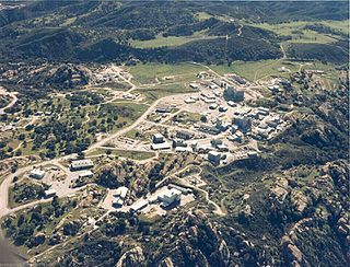
WThe Energy Technology Engineering Center (ETEC), was a government-owned, contractor-operated complex of industrial facilities located within the 2,850-acre (11.5 km2) Santa Susana Field Laboratory (SSFL), Ventura County, California. The ETEC specialized in non-nuclear testing of components which were designed to transfer heat from a nuclear reactor using liquid metals instead of water or gas. The center operated from 1966 to 1998. The ETEC site has been closed and is now undergoing building removal and environmental remediation by the U.S. Department of Energy.
 W
WExide is one of the world's largest producers, distributors and recyclers of lead-acid batteries. Lead-acid batteries are used in automobiles, golf carts, fork-lifts, and motorcycles. They are recycled by grinding them open, neutralizing the sulfuric acid, and separating the polymers from the lead and copper. In the US, 97 percent of the lead from car batteries is recycled - which is the highest recycling rate for any commodity. Most states require stores to take back old batteries.
 W
WThe Fernald Feed Materials Production Center is a Superfund site located within Crosby Township in Hamilton County, Ohio, as well as Ross Township in Butler County, Ohio. It was a uranium processing facility located near the rural town of New Baltimore, about 20 miles (32 km) northwest of Cincinnati, which fabricated uranium fuel cores for the U.S. nuclear weapons production complex from 1951 to 1989. During that time, the plant produced 170,000 metric tons uranium (MTU) of metal products and 35,000 MTU of intermediate compounds, such as uranium trioxide and uranium tetrafluoride.
 W
WThe Flint water crisis is an ongoing public health crisis that started in 2014, after the drinking water source for the city of Flint, Michigan, was contaminated. In April 2014, Flint changed its water source from treated Detroit Water and Sewerage Department water to the Flint River. Officials failed to apply corrosion inhibitors to the water. As a result, lead from aging pipes leached into the water supply, leading to extremely elevated levels of the heavy metal neurotoxin and exposing over 100,000 residents to elevated lead levels. A pair of scientific studies proved that lead contamination was present in the water supply. The city switched back to the Detroit water system on October 16, 2015. It later signed a 30-year contract with the new Great Lakes Water Authority (GLWA) on November 22, 2017.
 W
WThe 2015 Gold King Mine waste water spill was an environmental disaster that began at the Gold King Mine near Silverton, Colorado, when Environmental Protection Agency (EPA) personnel, along with workers for Environmental Restoration LLC, caused the release of toxic waste water into the Animas River watershed. They caused the accident while attempting to drain ponded water near the entrance of the mine on August 5. After the spill, the Silverton Board of Trustees and the San Juan County Commission approved a joint resolution seeking Superfund money.
 W
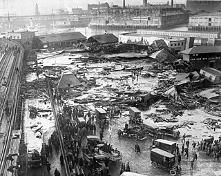
WThe Great Molasses Flood, also known as the Boston Molasses Disaster or the Great Boston Molasses Flood, occurred on January 15, 1919, in the North End neighborhood of Boston, Massachusetts. A large storage tank filled with 2.3 million US gal (8,700 m3) weighing approximately 13,000 short tons (12,000 t) of molasses burst, and the resultant wave of molasses rushed through the streets at an estimated 35 mph (56 km/h), killing 21 and injuring 150. The event entered local folklore and residents claimed for decades afterwards that the area still smelled of molasses on hot summer days.
 W
WThe Hanford Site is a decommissioned nuclear production complex operated by the United States federal government on the Columbia River in Benton County in the U.S. state of Washington. The site has been known by many names, including Hanford Project, Hanford Works, Hanford Engineer Works and Hanford Nuclear Reservation.
 W
WThere has been growing concern over the health effects arising from the September 11 attacks in the Financial District of Lower Manhattan. Within seconds of the collapse of the World Trade Center, building materials, electronic equipment, and furniture were pulverized and spread over the area.
 W
WFrom 1952 to 1966, Pacific Gas and Electric Company (PG&E) dumped about 370 million gallons of chromium-tainted wastewater into unlined wastewater spreading ponds around the town of Hinkley, California, located in the Mojave Desert.
 W
WThe Kesterson National Wildlife Refuge was an artificial wetland environment, created using agricultural runoff from farmland in California's Central Valley.
 W
WThe Kesterson Reservoir is the name of a former unit of the Kesterson National Wildlife Refuge which is part of the current San Luis National Wildlife Refuge. The site gained national attention during the latter half of the 20th century due to selenium toxicity and rapid die off of migratory waterfowl, fish, insects, plants and algae within the Kesterson Reservoir.
 W
WThe Kingston Fossil Plant coal fly ash slurry spill was an environmental and industrial disaster that occurred on Monday December 22, 2008, when a dike ruptured at a coal ash pond at the Tennessee Valley Authority's Kingston Fossil Plant in Roane County, Tennessee, releasing 1.1 billion US gallons of coal fly ash slurry. The coal-fired power plant, located across the Clinch River from the city of Kingston, used a series of ponds to store and dewater the fly ash, a byproduct of coal combustion. The spill released a slurry of fly ash and water, which traveled across the Emory River and its Swan Pond embayment, onto the opposite shore, covering up to 300 acres (1.2 km2) of the surrounding land. The spill damaged multiple homes and flowed into nearby waterways including the Emory River and Clinch River, both tributaries of the Tennessee River. It was the largest industrial spill in United States history.
 W
WKirtland Air Force Base is a United States Air Force base located in the southeast quadrant of the Albuquerque, New Mexico urban area, adjacent to the Albuquerque International Sunport. The base was named for the early Army aviator Col. Roy C. Kirtland. The military and the international airport share the same runways, making ABQ a joint civil-military airport.
 W
WLake Peigneur is a brackish lake in the U.S. state of Louisiana, 1.2 miles north of Delcambre and 9.1 mi (14.6 km) west of New Iberia, near the northernmost tip of Vermilion Bay. With a maximum depth of 200 feet, it is the deepest lake in Louisiana.
 W
WLibby is a city in northwestern Montana, United States and the county seat of Lincoln County. The population was 2,628 at the 2010 census.
 W
WLove Canal is a neighborhood in Niagara Falls, New York, infamous as the location of a 70-acre landfill that became the site of an enormous environmental disaster in the 1970s. Decades of dumping toxic chemicals harmed the health of hundreds of residents; the area was cleaned up over the course of 21 years in a Superfund operation.
 W
WThe Martin County coal slurry spill was a mining accident that occurred after midnight on October 11, 2000, when the bottom of a coal slurry impoundment owned by Massey Energy in Martin County, Kentucky, broke into an abandoned underground mine below. The slurry came out of the mine openings, sending an estimated 306 million US gallons of slurry down two tributaries of the Tug Fork River. By morning, Wolf Creek was oozing with the black waste; on Coldwater Fork, a 10-foot-wide (3.0 m) stream became a 100-yard (91 m) expanse of thick slurry.
 W
WThe Nevada National Security Site, known as the Nevada Test Site (NTS) until August 23, 2010, is a United States Department of Energy (DoE) reservation located in southeastern Nye County, Nevada, about 65 miles (105 km) northwest of the city of Las Vegas. Formerly known as the Nevada Proving Grounds, the site was established on January 11, 1951 for the testing of nuclear devices, covering approximately 1,360 square miles (3,500 km2) of desert and mountainous terrain. Nuclear weapons testing at the Nevada Test Site began with a 1-kiloton-of-TNT (4.2 TJ) bomb dropped on Frenchman Flat on January 27, 1951. Over the subsequent four decades, over one thousand nuclear explosions were detonated at the NTS. Many of the iconic images of the nuclear era come from the NTS. NNSS is operated by Mission Support and Test Services, LLC.
 W
WMV New Carissa was a freighter that ran aground on a beach near Coos Bay, Oregon, United States during a storm in February 1999 and subsequently broke apart. An attempt to tow the bow section of the ship out to sea failed when the tow line broke, and the bow was grounded again. Eventually, the bow was successfully towed out to sea and sunk. The stern section remained on the beach near Coos Bay. Fuel on board the ship was burned off in situ with napalm, but a significant amount was also spilled from the wreckage, causing ecological damage to the coastline.
 W
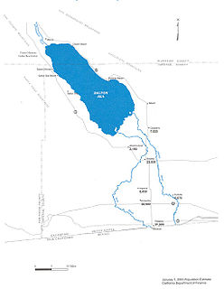
WThe New River flows north from near Cerro Prieto, through the city of Mexicali, Baja California, Mexico, into the United States through the city of Calexico, California, towards the Salton Sea. The river channel has existed since pre-historic times. However, the river as known today formed from a levee failure and massive flooding that re-created the Salton Sea.
 W
WThe 1966 New York City smog was a major air-pollution episode and environmental disaster, coinciding with that year's Thanksgiving holiday weekend. Smog covered the city and its surrounding area from November 23 to 26, filling the city's air with damaging levels of several toxic pollutants. It was the third major smog in New York City, following events of similar scale in 1953 and 1963.
 W
WOsborne Reef is an artificial reef off the coast of Fort Lauderdale, Florida, constructed of concrete jacks in a 50-foot (15 m) -diameter circle.
 W
WPicher is a ghost town and former city in Ottawa County, Oklahoma, United States. This was a major national center of lead and zinc mining at the heart of the Tri-State Mining District.
 W
WThe 2009 USS Port Royal grounding was a ship grounding by the United States Navy guided missile cruiser Port Royal off Oahu, Hawaii on 5 February 2009. The ship ran aground on a coral reef, damaging both the ship and the reef. The incident received wide press coverage in Hawaii, in part because of the damage caused to a sensitive coral environment, and also because the stranded ship was within sight of Honolulu off the airport.
 W
WThe Salton Sea is a shallow, saline, endorheic rift lake on the San Andreas Fault at the southern end of the U.S. state of California. It lies between, and within, the Imperial and Coachella valleys, all of which lie within the larger Salton Trough, a pull-apart basin that stretches to the Gulf of California in Mexico. The lake occupies the lowest elevations of the trough, known as the Salton Sink, where the lake surface is 236.0 ft (71.9 m) below sea level as of January 2018. The deepest point of the lake is only 5 ft (1.5 m) higher than the lowest point of Death Valley. The New, Whitewater, and Alamo rivers, combined with agricultural runoff, are the primary sources that feed the lake.
 W
WThe Santa Susana Field Laboratory is a complex of industrial research and development facilities located on a 2,668-acre (1,080 ha) portion of the Southern California Simi Hills in Simi Valley, California. It was used mainly for the development and testing of liquid-propellant rocket engines for the United States space program from 1949 to 2006, nuclear reactors from 1953 to 1980 and the operation of a U.S. government-sponsored liquid metals research center from 1966 to 1998. The site is located approximately 7 miles (11 km) northwest from the community of Canoga Park and approximately 30 miles (48 km) northwest of Downtown Los Angeles. Sage Ranch Park is adjacent on part of the northern boundary and the community of Bell Canyon along the entire southern boundary.
 W
WShpack Landfill is a hazardous waste site in Norton, Massachusetts. After assessment by the United States Environmental Protection Agency (EPA) it was added to the National Priorities List in October 1986 for long-term remedial action. The site cleanup is directed by the federal Superfund program. The Superfund site covers 9.4 acres, mostly within Norton, with 3.4 acres in the adjoining city of Attleboro. The Norton site was operated as a landfill dump accepting domestic and industrial wastes, including low-level radioactive waste, between 1946 and 1965. The source of most of the radioactive waste, consisting of uranium and radium, was Metals and Controls Inc. which made enriched uranium fuel elements for the U.S. Navy under contract with the U.S. Atomic Energy Commission. Metals and Controls merged with Texas Instruments in 1959. The Shpack landfill operation was shut down by a court order in 1965.
 W
WThe Summitville mine was a gold mining site in the United States, located in Rio Grande County, Colorado 25 miles (40 km) south of Del Norte. It is remembered for the environmental damage caused in the 1980s by the leakage of mining by-products into local waterways and then the Alamosa River.
 W
WThe Teton Dam was an earthen dam on the Teton River in Idaho, United States. It was built by the Bureau of Reclamation, one of eight federal agencies authorized to construct dams. Located in the eastern part of the state, between Fremont and Madison Counties, it suffered a catastrophic failure on June 5, 1976, as it was filling for the first time.
 W
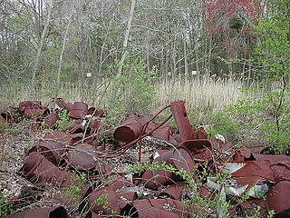
WThe Valley of the Drums is a 23-acre toxic waste site in northern Bullitt County, Kentucky, near Louisville, named after the waste-containing drums strewn across the area. After it had been collecting waste since the 1960s, the United States Environmental Protection Agency (EPA) analyzed the property and creek in 1979, finding high levels of heavy metal, polychlorinated biphenyls, and some 140 other chemical substances. It is known as one of the primary motivations for the passage of the Comprehensive Environmental Response, Compensation, and Liability Act, or Superfund Act of 1980. While the widely publicized Love Canal disaster is often credited as the reason the Superfund law was passed, Love Canal activist Lois Gibbs has said that Love Canal looked like a suburban community, while "Valley of the Drums became the visualization of the problem." Officially, cleanup began at the site in 1983 and ended in 1990, though later problems have been reported and investigated.
 W
WThe View-Master factory supply well in Beaverton, Oregon, was evaluated for public health effects by the Oregon Department of Human Services (ODHS) under a cooperative agreement with the Agency for Toxic Substances and Disease Registry (ATSDR). Workers there were potentially exposed to the industrial solvent trichloroethylene (TCE), classified by the International Agency for Research on Cancer (IARC) as a probable human carcinogen. At the factory, which closed in 2001, it had been estimated by ODHS that up to 25,000 workers may have been exposed to TCE via the factory's drinking water, which was drawn from a well on-site. However, further investigation showed that the actual number of employees who can be identified from employment records for the site is approximately half that number. In addition, the number of employees identified as having worked at the site for more than five years is likely to be less than 1,000. The site is now considered safe.
WWade Dump was a rubber recycling facility and illegal industrial waste storage and disposal facility in Chester, Pennsylvania. It was located at 1 Flower Street on the western bank of the Delaware River just north of the Commodore Barry Bridge. A toxic fire at the site in 1978 burned out of control for several days and resulted in 43 injured firefighters and criminal charges for the owner of the site. The first responders to the fire suffered long term health consequences and higher than normal cancer rates.