 W
WVojvodina is an autonomous region within Serbia located in the Pannonian plain, a region of central Europe. It shares borders with Romania in the east, Hungary in the north, Croatia in the west, and Bosnia and Herzegovina in the southwest. The southern border is administrative line to Šumadija and Western Serbia, Belgrade, and Southern and Eastern Serbia.
 W
WThe Aranca or Zlatica is a 117 km long river in the Banat region of Romania and Serbia, left tributary of the river Tisa.
 W
WBačka is a geographical and historical area within the Pannonian Plain bordered by the river Danube to the west and south, and by the river Tisza to the east. It is divided between Serbia and Hungary. Most of the area is located within the Vojvodina region in Serbia and Novi Sad, the capital of Vojvodina, lies on the border between Bačka and Syrmia. The smaller northern part of the geographical area is located within Bács-Kiskun County, in Hungary.
 W
WThe Banat is a geographical and historical region straddling between Central and Eastern Europe that is currently divided among three countries: the eastern part lies in western Romania ; the western part in northeastern Serbia ; and a small northern part lies within southeastern Hungary.
 W
WThe Bârzava or Brzava is a river in Romania and Serbia. The Bârzava is part of the Black Sea drainage basin and flows into the river Timiș. It is 166 km long and has a drainage area of 1,190 km².
 W
WThe Bega or Begej, is a 244 km long river in Romania and Serbia. It rises in the Poiana Ruscă Mountains in Romania, part of the Carpathian Mountains, and it flows into the Tisa river near Titel, Vojvodina, Serbia. Its drainage basin covers an area of 4,458 km2 (1,721 sq mi), of which 2,362 km2 (912 sq mi) in Romania.
 W
WThe Bega Canal or Begej Canal is a navigation canal of Romania and Serbia. It is the first navigation canal built on the present-day territory of Romania, and serves the city of Timișoara. Its name comes from the Bega river. It crosses the territory of Timiș County in western Romania and proceeds into the territory of Serbia, merging with Begej river near the village of Klek.
 W
WThe Bosut is a river in eastern Croatia and northwestern Serbia, a 186 km long left tributary of the Sava river. Its name from the Indo-European root *bhogj, meaning "to flow". The same root is seen in hydronym "Bosna".
 W
WThe Central Banat District is one of seven administrative districts of the autonomous province of Vojvodina, Serbia. It lies in the geographical region of Banat. According to the 2011 census results, it has a population of 186,851 inhabitants. The administrative center is the city of Zrenjanin.
 W
WThe Čik or Čiker is a river in northern Serbia. A 95 km (59 mi) long right tributary to the Tisa river, it flows entirely within the Bačka region of Vojvodina province.
 W
WThe Danube is Europe's second-longest river, after the Volga. It is located in Central and Eastern Europe.
 W
WThe Danube–Criș–Mureș–Tisa Euroregion is a euroregion located in Hungary, Romania and Serbia. It is named after four rivers: Danube, Criș, Mureș and Tisa.
 W
WDanube–Tisa–Danube Canal (DTD) is a canal system in Serbia. It is a unique hydro-engineering system for flood control and hydrotechnical management, amelioration, forestry, water supply, waste water evacuation, navigation, tourism, fishing, hunting.
 W
WDeliblato Sands is a large sand area covering around 300 km2 (120 sq mi) of ground in Vojvodina province, Serbia. It is located in southern Banat, situated between the river Danube and the southwestern slopes of the Carpathian Mountains. The sands are named after the village of Deliblato, in the municipality of Kovin. Its main masses are elliptical shaped hills with steppe grassland plains and steppe forests.
 W
WFruška gora is a mountain in northern Serbia. Most of the area is administratively part of Serbia, but a small part on its western side extends into eastern Croatia. The area under Serbian administration forms the country's oldest national park. Sometimes it's also referred to as the Jewel of Serbia due to its largely pristine landscape and protection effort, as well as Serbian Mount Athos, due to a big number of Orthodox monasteries.
 W
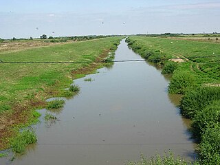
WGreat Bačka Canal is a canal in Serbia which runs from Bezdan to Bečej. The canal is 118 km long and part of the Danube-Tisa-Danube Canal system. The excavation works of Great Bačka Canal began in 1794 and went on until 1801 in Bács-Bodrog County, Kingdom of Hungary. The Bed of the canal is 17 m wide and 25 m wide at the top. The average depth is 3 m. The water of the canal is very polluted because it runs through industrial towns, such as Vrbas, Kula and Crvenka.
 W
WThe Great Hungarian Plain is a plain occupying the majority of Hungary. It is the largest part of the wider Pannonian Plain. Its territory significantly shrunk and its boundary was rewritten by the new political borders of post WW1 era, after the Treaty of Trianon in 1920.
 W
WThe Jegrička, is a river in northern Serbia, in the Bačka region of the Vojvodina province, a 65-kilometre long (40 mi) right tributary to the Tisa river.
 W
WThe Karaš or Caraș is a 110-kilometre (68 mi) long river in the Banat region of Vojvodina, Serbia and Romania and a left tributary of the Danube. The Karaš drains an area of 1,400 square kilometres (540 sq mi) and although it has been channeled it is not navigable.
 W
WThe Körös-ér or Kereš, is a river in southern Hungary and northern Serbia, a 90-kilometre-long (56 mi) right tributary to the Tisa river. It flows entirely within the Bačka region of both Hungary and Serbia (Vojvodina): 37 km (23 mi) in Hungary, 15 km (9.3 mi) as a border river and 29 km (18 mi) in Serbia.
 W
WThe Krivaja is a river in northern Serbia. With the length of 109 km (68 mi) it is the longest river that flows completely within the borders of Serbian province of Vojvodina.
 W
WLabudovo okno is a special nature reserve and a Ramsar site in Serbia.
 W
WLake Ledinci is a small artificial lake on the mountain of Fruška Gora in Serbia, near the city of Novi Sad.
 W
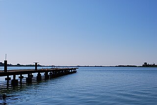
WLake Palić is a lake 8 kilometres (5.0 mi) from Subotica, near the town of Palić, in Serbia. It covers an area of 3.8 square kilometres (1.5 sq mi). The average depth of the lake is 2 metres.
 W
WLittle Bačka Canal, is a canal in Serbia which runs from Mali Stapar to Novi Sad. The canal is 66 km long and it is part of Danube-Tisa-Danube Canal system. The canal shortens waterway from Bezdan to Novi Sad by 75 km. Little Bačka Canal has 4 sluices. In the past, the canal was named after emperor Franz Josef and king Alexander.
 W
WMačva is a geographical and historical region in the northwest of Central Serbia, on a fertile plain between the Sava and Drina rivers. The chief town is Šabac. The modern Mačva District of Serbia is named after the region, although the region of Mačva includes only the northern part of this district. A small northern part of Mačva region is in the Autonomous Province of Vojvodina, in the Syrmia District.
 W
WThe Mostonga is a river in northern Serbia, in Bačka region of the province of Vojvodina, a 70-km long left tributary to the Danube. Once 92 km long, due to the extensive corrections and channeling of the river to make it part of the other canals, the Mostonga is shortened, turned into a series of channels and popularly referred to as a river there is no more.
 W
WThe Nadela or Nadel is a system of canals and rivers in northern Serbia, an 84 km (52 mi) long left tributary to the Danube in the Banat region of the Vojvodina province.
 W
WThe Nera is a 124-kilometre-long (77-mile) river running through Romania and Serbia. It is a left tributary of the Danube, which it joins near Banatska Palanka. Its length is 143 km (89 mi) and its basin size is 1,380 km2 (530 sq mi). The Nera is not navigable.
 W
WThe North Bačka District is one of seven administrative districts of the autonomous province of Vojvodina, Serbia. It lies in the Bačka geographical region. According to the 2011 census results, it has a population of 186,906 inhabitants. The administrative center of the district is the city of Subotica.
 W
WThe North Banat District is one of seven administrative districts of the autonomous province of Vojvodina, Serbia. It lies in the geographical regions of Banat and Bačka. According to the 2011 census, the district has a population of 146,690 inhabitants. The administrative center of the district is the city of Kikinda.
 W
WObedska bara is a large swamp-forest area and natural reserve stretching along the Sava River in Southern Syrmia (Serbia), some 40 km west of Belgrade.
 W
WThe Pannonian Basin, or Carpathian Basin, is a large basin in Central Europe. The geomorphological term Pannonian Plain is more widely used for roughly the same region though with a somewhat different sense, with only the lowlands, the plain that remained when the Pliocene Epoch Pannonian Sea dried out.
 W
WThe Pannonian island mountains is a term for isolated mountains scattered across the Pannonian Plain, chiefly its western and southern parts, in Hungary, Serbia and Croatia. In prehistoric times, these mountains were islands of the ancient Pannonian Sea that disappeared about 600,000 years ago.
 W
WThe Plazović or Kiđoš, is a river in southern Hungary and northern Serbia. It flows entirely within the Bačka region, and during its 129 km long course, on a section of only 15 km, it crosses the Hungarian-Serbian border eight times.
 W
WPomorišje is a historical geographical region on the banks of the river Mureş that in the past has had a sizable ethnic Serb population. The region is mostly divided between Romania and Hungary, with small part of it in northern Serbia. Today, a Serb minority is present in parts of the region that are part of Romania and Hungary.
 W
WPosavina is a geographical region that stretches along the Sava river, encompassing only the inner areas of the Sava river basin, that are adjacent or near to the Sava river itself, in Croatia, Bosnia and Herzegovina, and Serbia.
 W
WPotisje is the name of the Tisa river basin parts located in Serbia, in the autonomous province of Vojvodina. The river Tisa flow between Banat and Bačka regions.
 W
WŠajkaška (Шајкашка) is a historical region in northern Serbia. It is southeastern part of Bačka, located in the Autonomous Province of Vojvodina. Territory of Šajkaška is divided among four municipalities: Titel, Žabalj, Novi Sad, and Srbobran. Historical center of Šajkaška is Titel.
 W
WThe South Bačka District is one of seven administrative districts of the autonomous province of Vojvodina, Serbia. Geographically it lies in the southern part of Bačka and northern part of Syrmia. According to the 2011 census results, it has a population of 615,371 inhabitants. The administrative center of the district is the city of Novi Sad, which is also the capital and the largest city of the Autonomous Province of Vojvodina.
 W
WThe South Banat District is one of seven administrative districts of the autonomous province of Vojvodina, Serbia. The administrative center of the district is the city of Pančevo. The district lies in the region of Banat. According to the 2011 census results, it has a population of 291,327 inhabitants.
 W
WThe Srem District is one of seven administrative districts of the autonomous province of Vojvodina, Serbia. It lies in the geographical regions of Syrmia and Mačva. According to the 2011 census results, it has a population of 312,278 inhabitants. The administrative center is the city of Sremska Mitrovica.
 W
WStražilovo is a wooded valley in the Fruška Gora mountain, Serbia. It is situated on the northeastern slopes of the Fruška Gora National park, about 5 km from Sremski Karlovci, and about 15 km from Novi Sad. It is the place where the monument is erected to the famous Serbian poet Branko Radičević. On weekends and during holidays, it is packed with visitors from nearby cities. There is a mountaineers' hut in Stražilovo, as it is also the starting point of the "Fruška Gora transversale" hiking trail, which runs around the mountain for more than 160 kilometers. Near Stražilovo, there are several Orthodox monasteries which date mostly from the 16th century.
 W
WThe Studva is a river in eastern Croatia and northern Serbia, a 37 km-long right tributary to the Bosut river. It flows entirely within the Syrmia region of both Croatia and Serbia (Vojvodina).
 W
WSyrmia is a region of the southern Pannonian Plain, which lies between the Danube and Sava rivers. It is divided between Serbia and Croatia. Most of the region is flat, with the exception of the low Fruška gora mountain stretching along the Danube in its northern part.
 W
WThe Timiș or Tamiš is a 359 km (223 mi) long river that flows through the Banat region of Romania and Serbia and joins the Danube near Pančevo, in northern Serbia. Due to its position in the region, it has been labeled as the "spine of the Banat".
 W
WThe Tisza, Tysa or Tisa, is one of the main rivers of Central and Eastern Europe. Once, it was called "the most Hungarian river" because it flowed entirely within the Kingdom of Hungary. Today, it crosses several national borders.
 W
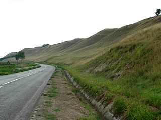
WTitelski Breg or Titel Hill is a loess plateau situated in the Vojvodina province, Serbia. It is located in south-eastern Bačka, between the town of Titel in the south, the villages of Lok, Vilovo and Šajkaš in the south-west, the village of Mošorin in the north, and the river Tisa in the east. It is 18 km long and 7.5 km wide, with steep cliffs, up to 60 m high along the Tisa. The hill has a flat top with an elevation of around 100 to maximally 128 m. The cliffs and the flat top give it a mesa-like appearance. The hill is an interesting geographical feature because it is the only hill in Bačka region, most of which is a flat plain. It is a loess formation deposited during the Pleistocene, showing six distinct bands, visible in gullies at the edge.
 W
WThe Vršac Mountains, also known as Vršac Hill, are located in the Banat region near the city of Vršac, Serbia and partially also in Romania. They represent an independent and distinct massif, 19 kilometers long and spreading on an area of 170 square kilometers, of which 122 belong to Serbia and 48 to Romania.
 W
WThe West Bačka District is one of seven administrative districts of the autonomous province of Vojvodina, Serbia. It lies in the geographical region of Bačka. It has a population of 188,087 inhabitants. The administrative seat of the district is the city of Sombor.
 W
WThe Zasavica is a bog in the region of Mačva, west-central Serbia. With Obedska bara and Carska Bara one of the major wildlife refuges and one of the last authentically preserved wetlands in Serbia. In the 2000s it became a popular attraction with the successful reintroduction of beavers, which had become extinct 100 years before.