 W
WThe following is a list of cities and towns in Botswana with population of over 3,000 citizens. State capitals are shown in boldface.
 W
WBobirwa Subdistrict is a jurisdiction in Botswana. It is populated by the Babirwa (Ba-Birwa) people who came from Transvaal in present-day South Africa.
WLedumadumana is a village in Botswana, located about 10 km (6.2 mi) northwest of Gaborone, the capital of Botswana.
 W
WGhanzi is a town in the middle of the Kalahari Desert the western part of the Republic of Botswana in southern Africa. At the time of the 2011 census, there were 12,167 people living in the town with another 861 nearby. It is the administrative center of Ghanzi District and is known as the "Capital of the Kalahari". Ghanzi District measures 117,910 square kilometres and is bordered by Ngamiland to the north, Central District to the east, and Kgalagadi and Kweneg Districts to the south. Its western border is shared with Namibia to 203 km. Have shopping options in Spar, Choppis and food & stay at Kalahari Arms Hotel.
 W
WGumare or Gomare is a rural village located in the North-West District of Botswana, near the Okavango Delta. The population of Gumare was 6,067 in 2001 census, but had risen to 8,532 iby the 2011 census.
WHukuntsi is a village in Kgalagadi District (Kalahari) in Botswana.
 W
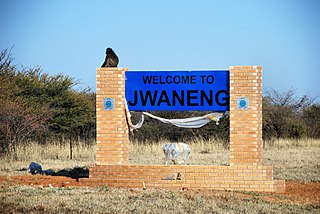
WJwaneng is a town located in the Southern District of Botswana, but it is not part of this, being a separate district, with its own Town Council.
WKanye is a town in southern Botswana, located 83 kilometres (52 mi) south-west of the capital, Gaborone. It is the administrative centre of the Southern District, and had a population of 45,196 at the 2011 census, making it the eighth-largest town in the country. Kanye is the traditional capital of the Ngwaketse tribe, who first settled in the area in the 1790s. The town is the longest continuously occupied tribal capital in the country.
 W
WKasane is a town in Botswana, close to Africa's 'Four Corners', where four countries almost meet: Botswana, Namibia, Zambia and Zimbabwe. It is at the far north-eastern corner of Botswana where it serves as the administrative center of the Chobe District. The population of Kasane was 9,008 in 2011 census.
WKgomokasitwa is a small village in the Southern District of Botswana, located some few kilometers north of Lobatse. To reach the village you travel by the A2 road between Lobatse and Kanye, then branch to the right at the Molapowabojang ward called Tshweneyagae. Kgomokasitwa has a population of about 1423. The village falls under the administration of the Southern District Council which is headquartered in Kanye, Botswana. For civil administration it falls under Moshupa Sub District.
WKopong is a small village in Kweneng District of Botswana. It is located around 25 km north of Gaborone, the capital of Botswana. The population was 5,571 in 2001 census and 9,520 at the 2011 census, making it the sixth largest settlement in Kweneng. It is now becoming a suburb of Gaborone agglomeration home to 421,907 inhabitants at the 2011 census. It is also home to the Gospel of God's Grace Ministries, a church with a mandate to bring souls to Heaven.
WLecheng is a village located in the Central District of Botswana. It had 3,334 inhabitants at the 2011 census.
WLobatse is a town in south-eastern Botswana, 70 kilometres south of the capital Gaborone, situated in a valley running north towards Gaborone. Lobatse has a population of 29,800. The town is an administrative district, with a town council.
WLotlhakane is a large village located in the Southern District of Botswana. It had 4,828 inhabitants at the 2011 census.
WMahalapye is a town located in the Central District of Botswana. The town has about 41,000 inhabitants and is situated along the main road between the capital Gaborone and the second largest city Francistown. Mahalapye has a bus station, a railway station, a couple of hotels and a market area with many shops and fast food restaurants, Water Shed mall is the latest attraction to those travelling from Gaborone to Francistown, great place for refreshments. It also has several petrol stations, some open 24 hours per day. Being situated on the edge of the Kalahari desert it is quite dry, and the local waterways are dry except during the rainy season. In recent times, it has become a convenient stop-over town for travelers travelling to and from Gaborone.
WMaitengwe is a large village located in the Central District of Botswana. It had 5,890 inhabitants at the 2011 census.It is one of many developing villages in the country and best known for its festive celebrations.
WMandunyane is named after Kgosi Harry Mandunyane I, who ruled since 1973 when the village was established. The village is located in the Central District of Botswana in Tonota subdistrict. It is approximately 8 km north west of Tonota and roughly 30 km south west of Francistown.
WManyana is a village located in the Southern District of Botswana. It had 3,550 inhabitants at the 2011 census.
WMarobela is a village located in the Central District of Botswana. It had 1,672 inhabitants at the 2011 census.
WMasunga /ˈmɑːsunɡʌ/ is a Bakalanga settlements in the North-East District of Botswana. The village is the Headquarters of the North East District. The nearest city is Francistown which is about 120 km (75 mi) away. The Chief of the region is Kgosi Thabo Maruje Masunga III, who took over from his uncle Christopher Masunga.
 W
WMaun is the fifth-largest town in Botswana. As of 2011, it had a population of 55,784. Maun is the "tourism capital" of Botswana and the administrative centre of Ngamiland district. Francistown and Maun there are linked by the A3 highway. It is also the headquarters of numerous safari and air-charter operations who run trips into the Okavango Delta.
WMmathethe is a village located in the Southern District of Botswana. It had 5,078 inhabitants at the 2011 census.
 W
WMochudi is one of the larger villages in Botswana with a population of 44,815 people in 2011. It is situated in the Bakgatla tribal region, in Kgatleng District, about 37 km (23 mi) northeast of Gaborone. The village lies several kilometres from the main Gaborone–Francistown road, and can be accessed through a short turn at Pilane. Mochudi was settled by the Tswana people in 1871.The main attraction in Mochudi is the Phuthadikobo Museum which is perched at the top of a hill and holds a rich history of Bakgatla tribe and Batswana in general
WMogoditshane is a town located in the Kweneng District of Botswana. Its population was 14,246 at the 2001 census and 57,637 at the 2011 census. It is in conurbation to the capital Gaborone whose agglomeration is now home to 421,907 inhabitants at the 2011 census.
WMolepolole is a large town in Kweneng District, Botswana.
WMoshupa is a large village in the Southern District of Botswana with a population of 20016 per the 2011 census. The people of Moshupa are called the Bakgatla-ba-ga Mmanaana, a group also found in Thamaga. Along with the related Bakgatla-ba-ga Kgafela of Mochudi, they arrived to the region from the Transvaal region in South Africa throughout the eighteenth century.
WNcojane or Nojane is a town in the Kalahari desert of Ghanzi District, western Botswana. It is located 20 kilometres from the border with Namibia, and it has both primary and secondary schools and a clinic. The population was 1,439 in 2001 census.
WNgamiland East is one of the subdistricts of Ngamiland District of Botswana.
WNgamiland West is one of the subdistricts of Ngamiland District of Botswana.
WNkange is a village located in the Central District of Botswana. It had 3,550 inhabitants at the 2011 census.
WOkavango Delta region is one of the subdistricts of Ngamiland District of Botswana.
WPilane is a village in Kgatleng District of Botswana. It is located 10 km south-west of the district capital, Mochudi. The population was 1,178 in 2001 census.
WRamokgonami is a village located in the Central District of Botswana. It had 4,486 inhabitants at the 2011 census.
WRamokgwebana is a village in the North-East District of Botswana, close to the eastern border, which is defined by the Ramokgwebana River. Plumtree, Zimbabwe is on the other side of the border crossing.
WRamotswa is a village in South-East District of Botswana, southwest of the capital of Gaborone. The population was 27,760 in 2011 census. It is the tribal capital of the BaLete, an ethnic majority springing from the Nguni tribe.
WRanaka is a village located in the Southern District of Botswana. It had 3,089 inhabitants at the 2012 census.
WSatau is a village in the Chobe District of Botswana, at 18°0′45″ south and 24°24′22″ east. The village is located in the eastern part of the district, which before 2001 formed part of the North-West District. Although a traditional village, Satau it has a primary school, a post office, a health post and a library. Electricity is also available in the village.
WSebina is a village located in the Central District of Botswana. It had 3,276 inhabitants at the 2011 census.
WSefhare is a Botswana village located in the Central district. According to the 2011 census, the village has 5295 inhabitants.
WSeleka is a village in near Mahalapye in the Central District of Botswana. It derives its name from the name of one of the four subgroups of the Rolong people. Seleka had 1157 inhabitants in 2011
WShakawe is a village located in the northwest corner of Botswana at the beginning of the Okavango Delta, close to Namibia and Angola. Shakawe is awakening from its former status as a sleepy little outpost on the Okavango. For travellers, Shakawe means a Botswana entry or exit stamp or a staging post for a visit to the Tsodilo Hills, 40 km away. For Southern African holiday-makers, it is most often the start of a fishing trip in the Okavango Panhandle. It also provides access to the Caprivi Strip.
WShashe-Mooke is a large village located in the Central District of Botswana. It had 3,380 inhabitants at the 2011 census.
WShoshong is a town in Botswana, formerly the chief settlement of the eastern Bamangwato.
WTati Siding is a village located in the North-East District of Botswana. It had 8,112 inhabitants at the 2011 census.
 W
WThamaga is a large village located in the Kweneng District of Botswana and about 40 km west of the capital city Gaborone. It is home to 19,365 inhabitants at the 2011 census. It is becoming year by year like a suburb part of the Gaborone agglomeration, home to 421,907 inhabitants at the 2011 census.
WTlokweng is a village located directly adjacent to the capital of Botswana, Gaborone, in the South-East District. It can be considered part of the conurbation of Gaborone. Tlokweng stands on the other side of the river, and is on the road to the border with South Africa, the border post being just 15 km to the east. The population was 35,982 at the 2011 census. It is now part of Gaborone agglomeration, home to 421,907 inhabitants at the 2011 census. The tribe originating from Tlokweng is referred to as Batlokwa. Many people from across Botswana have come to seek permanent and sometimes temporary settlement in Tlokweng because of its proximity to the capital city where most jobs are.
WTobane is a small village in the eastern part of Botswana about 20 km from the copper/nickel mining town of Selebi-Phikwe. The village has access to the town through a tarred road. The Motloutse River passes the village on the northeastern side. The village has a lot of facilities such as clean water from the Shashe dam, electricity, mobile phone connection through Orange,Bemobile and Mascom wireless. It also has landline service through Botswana Telecommunications Cooperation. There is a clinic, a primary school, and a Junior school(Motlhasedi I community junior secondary school) in the area. The population of the village is roughly 1925. The Regent chief is Nametshego Nengu.
WTonota is a village located in the Central District of Botswana.
WToteng is a village in the north west of Botswana, Ngamiland. The town is the location of the oldest "directly dated evidence of cattle in southern Africa". Nearby towns are Sehitwa and Bobideng to the west, Tsau and Gumare to the north and Maun to the northeast.
 W
WTsabong, also spelled Tshabong, is the administrative centre of the Kgalagadi District in Botswana. It is located in the Kalahari Desert. The population was 8939 at the 2011 census.
WTumasera is a village located in the Central District of Botswana. It had 3,136 inhabitants at the 2011 census.
 W
WTutume is a large Bakalanga village located in the Central District of Botswana, about 50 km from the Zimbabwe border gate at Maitengwe. The nearest city is Francistown, about 100 km away. The village is a sub district headquarters and has a population of 13,000.It is made up of wards: Madikwe, Selolwane, Thini and Magapatona. In each ward there is a headman and his advisers in the kgotla. The main kgotla is located in Madikwe ward near Tutume Central Primary School. The village was named after the river "TUTUME", in Kalanga they will say "gwizi go Tutuma", meaning that the river was overflowing.