 W
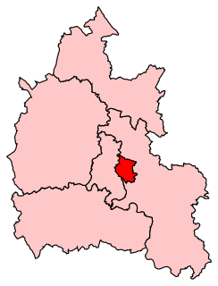
WOxford East is a constituency represented in the House of Commons of the UK Parliament by Anneliese Dodds of the Labour Party, who also serves as Shadow Chancellor of the Exchequer.
 W
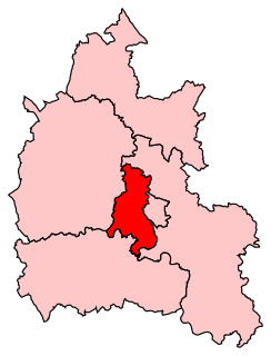
WOxford West and Abingdon is a constituency represented in the House of Commons of the UK Parliament since 2017 by Layla Moran, a Liberal Democrat.
 W
WBarton is a suburb of Oxford, England on the city's eastern edge. Barton is just outside the Northern By-Pass Road, north of Headington Roundabout where North Way and the Eastern By-pass meet London Road.
 W
WBinsey is a village by the River Thames about 1.5 miles (2.4 km) northwest of the centre of Oxford. It is the opposite side of the river from Port Meadow and about 1 mile (1.6 km) southwest of the ruins of Godstow Abbey.
 W
WBlackbird Leys is a civil parish and ward in Oxford, England. According to the 2011 census, the population of the ward stood at 6,077. Unlike most parts of the City of Oxford, the area has a civil parish. The civil parish was created in 1990. In 2011 the population was recorded as 13,100.
 W
WBotley is a village in the civil parish of North Hinksey in the ceremonial county of Oxfordshire, just west of the Oxford city boundary. Historically part of Berkshire, it stands on the Seacourt Stream, a stream running off the River Thames. The intersection of the A34 and A420 is to the village's north.
 W
WCowley in Oxford, England, is a residential and industrial area that forms a small conurbation within Oxford.
WCowley in Oxford, England, is a residential and industrial area that forms a small conurbation within Oxford.
 W
WCutteslowe is a suburb of north Oxford, England, between Sunnymead and Water Eaton.
 W
WDean Court is a suburb 2 miles (3.2 km) west of the centre of Oxford, England. Dean Court was part of Berkshire until the 1974 local government boundary changes transferred it to Oxfordshire.
WDonnington is a small housing estate in Oxford, England located adjacent to the River Thames in the post-war housing developments either side of Donnington Bridge and around Boundary Brook Road. It is bordered by Iffley Village to the south, Iffley Fields to the north and Cowley to the east.
WCowley in Oxford, England, is a residential and industrial area that forms a small conurbation within Oxford.
 W
WGodstow is about 2.5 miles (4 km) northwest of the centre of Oxford. It lies on the banks of the River Thames between the villages of Wolvercote to the east and Wytham to the west. The ruins of Godstow Abbey, also known as Godstow Nunnery, are here. A bridge spans the Thames and the Trout Inn is at the foot of the bridge across the river from the abbey ruins. There is also a weir and Godstow lock.
WGrandpont is a mainly residential area in south Oxford. It is west of Abingdon Road, and consists mainly of narrow streets that run at right-angles to the main road, with terraced late-Victorian and Edwardian houses.
WBlackbird Leys is a civil parish and ward in Oxford, England. According to the 2011 census, the population of the ward stood at 6,077. Unlike most parts of the City of Oxford, the area has a civil parish. The civil parish was created in 1990. In 2011 the population was recorded as 13,100.
WHarcourt Hill is a hill and community in North Hinksey in Oxfordshire, England, west of the city of Oxford. There is a good view of the city from the hill. It lies between Hinksey Hill to the southeast, Boars Hill to the south and Botley to the north. Until 1974 it was in Berkshire, but was transferred to Oxfordshire in that year.
 W
WHeadington is an eastern suburb of Oxford, England. It is at the top of Headington Hill overlooking the city in the Thames Valley below. The life of the large residential area is centred upon London Road, the main road between London and Oxford.
 W
WHeadington Hill is a hill in the east of Oxford, England, in the suburb of Headington. The Headington Road goes up the hill leading out of the city. There are good views of the spires of Oxford from the hill, especially from the top of South Park.
 W
WHeadington Quarry is a residential district of Oxford, England, located east of Headington and west of Risinghurst, just inside the Oxford ring road in the east of the city. To the south is Wood Farm. Today the district is also known colloquially as "Quarry". The area, now residential, is considerably uneven due to previous quarrying in the area.
 W
WHolywell is a parish in Oxford, England. The toponym is derived from the well of Saint Winifred and Saint Margaret.
 W
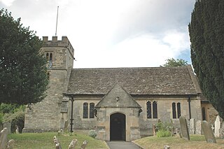
WIffley is a village in a designated Conservation Area in Oxfordshire, England. It lies within the boundaries of the city of Oxford, between Cowley and the estates of Rose Hill and Donnington, and in proximity to the River Thames (Isis). A notable feature is its largely unchanged Norman church, St Mary the Virgin, which has a modern stained glass Nativity window designed by John Piper and another window designed by Roger Wagner. The church is listed Grade I.
 W
WJericho is an historic suburb of the English city of Oxford. It consists of the streets bounded by the Oxford Canal, Worcester College, Walton Street and Walton Well Road. Located outside the old city wall, it was originally a place for travellers to rest if they had reached the city after the gates had closed. The name Jericho may have been adopted to signify this 'remote place' outside the wall.
 W
WLittlemore is a district and civil parish in Oxford, England. The civil parish includes part of Rose Hill. It is about 2 1⁄2 miles (4 km) southeast of the city centre of Oxford, between Rose Hill, Blackbird Leys, Cowley, and Sandford-on-Thames. The 2011 Census recorded the parish's population as 5,646, with the electoral ward having a total population of 6,441.
 W
WMarston is a village in the civil parish of Old Marston about 2 miles (3 km) northeast of the centre of Oxford, England. It was absorbed within the city boundaries in 1991. It is commonly called Old Marston to distinguish it from the suburb of New Marston that developed between St. Clement's and the village in the 19th and 20th centuries. The A40 Northern Bypass, part of the Oxford Ring Road forms a long north-west boundary of the village and parish and a limb, namely a distributary, of the Cherwell forms the western boundary.
WBotley is a village in the civil parish of North Hinksey in the ceremonial county of Oxfordshire, just west of the Oxford city boundary. Historically part of Berkshire, it stands on the Seacourt Stream, a stream running off the River Thames. The intersection of the A34 and A420 is to the village's north.
WHeadington is an eastern suburb of Oxford, England. It is at the top of Headington Hill overlooking the city in the Thames Valley below. The life of the large residential area is centred upon London Road, the main road between London and Oxford.
WNew Hinksey is a suburb in the south of the city of Oxford.
 W
WNew Marston is a suburb about 1.25 miles (2 km) northeast of the centre of Oxford, England.
 W
WThe Norham Manor estate is a residential suburb in Oxford, England. It is part of central North Oxford. To the north is Park Town with its crescents, to the east is the River Cherwell, to the south are the University Parks and to the west is Walton Manor, on the other side of Banbury Road.
WNorth Hinksey is a village and civil parish in Oxfordshire, England, immediately west of Oxford. The civil parish includes the large settlement of Botley, effectively a suburb of Oxford. North Hinksey was part of Berkshire until the 1974 boundary changes transferred it to Oxfordshire.
 W
WNorth Oxford is a suburban part of the city of Oxford in England. It was owned for many centuries largely by St John's College, Oxford and many of the area's Victorian houses were initially sold on leasehold by the College.
WNorthway is a suburban area in northeast Oxford, England, just inside the Oxford ring road. It is close to Headington Hill and with it forms a ward in Oxford. It mainly consists of social housing built by Oxford City Council in the 1950s, though many houses and apartments are now in private ownership.
WMarston is a village in the civil parish of Old Marston about 2 miles (3 km) northeast of the centre of Oxford, England. It was absorbed within the city boundaries in 1991. It is commonly called Old Marston to distinguish it from the suburb of New Marston that developed between St. Clement's and the village in the 19th and 20th centuries. The A40 Northern Bypass, part of the Oxford Ring Road forms a long north-west boundary of the village and parish and a limb, namely a distributary, of the Cherwell forms the western boundary.
 W
WOsney or Osney Island is a riverside community in the west of the city of Oxford, England. In modern times the name is applied to a community also known as Osney Town astride Botley Road, just west of the city's main railway station, on an island surrounded by the River Thames, Osney Ditch and another backwater connecting the Thames to Osney Ditch.
 W
WOxpens Road is a road in central Oxford, England, linking west and south Oxford. It is named after the marshy area of Oxpens, next to one of the branches of the River Thames in Oxford. It forms part of the A420 road.
WPark Town is a small residential area in central North Oxford, a suburb of Oxford, England. It was one of the earliest planned suburban developments in the area and most of the houses are Grade II listed.
 W
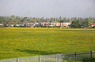
WPort Meadow is a large meadow of open common land beside the River Thames to the north and west of Oxford, England.
WHeadington Quarry is a residential district of Oxford, England, located east of Headington and west of Risinghurst, just inside the Oxford ring road in the east of the city. To the south is Wood Farm. Today the district is also known colloquially as "Quarry". The area, now residential, is considerably uneven due to previous quarrying in the area.
 W
WRedbridge is located in south Oxford, England, at the southern end of Abingdon Road near the Oxford Ring Road. Redbridge takes its name from a brick bridge, locally known as the Red Bridge, which carries Old Abingdon Road over the Cherwell Valley railway line.
WRisinghurst is an outlying residential area of Oxford, England, just outside the Eastern Bypass Road which forms part of the Oxford ring road. It is about 1 mile (1.6 km) east of the centre of Headington and 3 miles (4.8 km) east of Oxford city centre.
WRose Hill is a residential area, with some housing that has been council-owned, on the southern outskirts of Oxford, England. According to the 2001 Census, the population of Rose Hill and the adjoining village of Iffley was 4,667.
 W
WSt Clement's is a district in Oxford, England, on the east bank of the River Cherwell. Its main road, St Clement's Street, links The Plain near Magdalen Bridge with London Place at the foot of Headington Hill at the junction with Marston Road to the north.
WSt Ebbes is a district of central Oxford, England, southwest of Carfax. St Ebbes Street runs south from the western end of Queen Street.
 W
WThe St John Street area is a residential area close to the city centre in Oxford, England. It consists of two streets, St John Street and Beaumont Buildings. Wellington Square is to the north, Pusey Street to the east, and Beaumont Street to the south.
WOxpens Road is a road in central Oxford, England, linking west and south Oxford. It is named after the marshy area of Oxpens, next to one of the branches of the River Thames in Oxford. It forms part of the A420 road.
 W
WThe Oxford University Science Area in Oxford, England, is where most of the science departments at the University of Oxford are located.
 W
WSummertown in North Oxford is a suburb of Oxford, England.
WSunnymead is a suburb in the northern part of Oxford, England, just south of the Oxford Ring Road (A40). Close by are the suburbs of Cutteslowe to the north, Summertown to the south and Upper Wolvercote to the west. To the east is the River Cherwell, which flows south towards central Oxford.
WWalton Manor is a residential suburb in Oxford, England. It is north of Jericho and the Radcliffe Observatory Quarter and forms part of North Oxford. The street layout and many of the area's buildings date from the mid-19th century. It was developed on land belonging to St John's College, Oxford.
 W
WThe Waterways is housing estate in North Oxford, England. The Oxford Canal runs through the centre of the estate and it is bounded on the east by the Cherwell Valley railway line. To the west beyond the railway line are Port Meadow and the River Thames. The estate begins in the south as a continuation of Frenchay Road, part of Victorian North Oxford, and as Elizabeth Jennings Way connects with the Woodstock Road (A4144) at the northern end of the estate.
 W
WWolvercote is a village that is part of the City of Oxford, England. It is about 3 miles (5 km) northwest of the city centre, on the northern edge of Wolvercote Common, which is itself north of Port Meadow and adjoins the River Thames.
 W
WWolvercote Common is an area of grassed common land north of Port Meadow in Oxford, England.
 W
WWood Farm is a residential district of Oxford, England, south of Headington in the southeast of the city. It largely consists of social housing built in the 1950s and 1960s, originally intended to house workers from the nearby car factory. The Eastern By-Pass is to the east, Cowley is to the southwest and Headington Quarry is to the north.