 W
WA burgh is an autonomous municipal corporation in Scotland and Northern England, usually a city, town, or toun in Scots. This type of administrative division existed from the 12th century, when King David I created the first royal burghs. Burgh status was broadly analogous to borough status, found in the rest of the United Kingdom. Following local government reorganisation in 1975, the title of "royal burgh" remains in use in many towns, but now has little more than ceremonial value.
 W
WThe following list includes all effective burghs in Scotland from the coming into force of the Burgh Police (Scotland) Act 1892, in 1893. "Ineffective" burghs, which had not used legislation to adopt a "police system", take on local government duties and reform their town councils, were abolished on this date.
 W
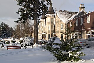
WAirdrie is a town in North Lanarkshire, Scotland. It lies on a plateau roughly 400 ft above sea level, and is approximately 12 miles (19 km) east of Glasgow city centre. As of 2012, the town had a population of around 37,130. Historically part of Lanarkshire, Airdrie forms part of a conurbation with its neighbour Coatbridge, in what is commonly known as the Monklands, formerly a district..
 W
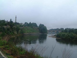
WAlloa is a town in Clackmannanshire in the Central Lowlands of Scotland. It is on the north bank of the Forth at the spot where some say it ceases to be the River Forth and becomes the Firth of Forth. Alloa is south of the Ochil Hills, 5.5 miles (8.9 km) east of Stirling and 7.9 miles (12.7 km) north of Falkirk; by water Alloa is 25 miles (40 km) from Granton.
 W
WAnderston is an area of Glasgow, Scotland. It is on the north bank of the River Clyde and forms the south western edge of the city centre. It was an independent burgh of barony from 1824 until it was incorporated into the City of Glasgow in 1846.
 W
WArdrossan is a town on the North Ayrshire coast in southwestern Scotland. The town has a population of roughly 11,000 and forms part of a conurbation with Saltcoats and Stevenston known as the 'Three Towns'. Ardrossan is located on the east shore of the Firth of Clyde.
 W
WBarrhead is a town in East Renfrewshire, Scotland, 13 km (8.1 mi) south-west of Glasgow city centre on the edge of the Gleniffer Braes. At the 2011 census its population was 17,268.
 W
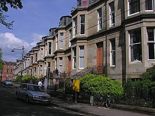
WBearsden is a town in East Dunbartonshire, Scotland, on the northwestern fringe of Greater Glasgow. Approximately 6 miles (10 km) from Glasgow City Centre, the town is effectively a suburb, and its housing development coincided with the 1863 introduction of a railway line. The town was named after Bearsden railway station, which was named after a nearby cottage.
 W
WBiggar is a town and former burgh in South Lanarkshire, Scotland. It is situated in the Southern Uplands, near the River Clyde, on the A702. The closest towns are Lanark and Peebles, and as such Biggar serves a wide rural area. The population of the town at the 2011 census was 2,294, and the latest recorded figures in June 2018 estimate it had grown to 2,550.
 W
WBishopbriggs is a town in East Dunbartonshire, Scotland. It lies on the northern fringe of Greater Glasgow, approximately 4 miles (6 km) from the city centre. Historically in Lanarkshire, the area was once part of the historic parish of Cadder - originally lands granted by King William the Lion to the Bishop of Glasgow, Jocelin, in 1180. It was later part of the county of Lanarkshire, and then an independent burgh from 1964 to 1975. Today, Bishopbriggs' close geographic proximity to Glasgow now effectively makes it a suburb and commuter town of the city. The town's Gaelic name Coille Dobhair reflects the name of the old parish of Cadder. It was ranked the 2nd most desirable postcode in Scotland to live in following a study by the Centre for Economic and Business Research in 2015 and 2016.
 W
WBroughty Ferry is a suburb of Dundee, Scotland. It is situated four miles east of the city centre on the north bank of the Firth of Tay. The area was a separate burgh from 1864 until 1913, when it was incorporated into Dundee.
 W
WGrantown-on-Spey is a town in the Highland Council Area, historically within the county of Moray. It was founded in 1765 as a planned settlement on a low plateau at Freuchie beside the river Spey at the northern edge of the Cairngorm mountains, about 20 miles (32 km) south-east of Inverness.
 W
WCalton, known locally as The Calton, is a district in the Scottish city of Glasgow. It is situated north of the River Clyde, and just to the east of the city centre. Calton's most famous landmark is the Barras street market and the Barrowland Ballroom, one of Glasgow's principal musical venues.
 W
WThe Canongate is a street and associated district in central Edinburgh, the capital city of Scotland. The street forms the main eastern length of the Royal Mile while the district is the main eastern section of Edinburgh's Old Town. It began when David I of Scotland, by the Great Charter of Holyrood Abbey c.1143, authorised the Abbey to found a burgh separate from Edinburgh between the Abbey and Edinburgh. The burgh of Canongate that developed was controlled by the Abbey until the Scottish Reformation when it came under secular control. In 1636 the adjacent city of Edinburgh bought the feudal superiority of the Canongate but it remained a semi-autonomous burgh under its own administration of bailies chosen by Edinburgh magistrates, until its formal incorporation into the city in 1856.
 W
WColdstream is a town and civil parish in the Scottish Borders area of Scotland. A former burgh, Coldstream is the home of the Coldstream Guards, a regiment in the British Army.
 W
WCowdenbeath is a town and burgh in west Fife, Scotland. It is 5 miles (8 km) north-east of Dunfermline and 18 miles (29 km) north of the capital, Edinburgh. The town grew up around the extensive coalfields of the area and became a police burgh in 1890. According to a 2008 estimate, the town has a population of 14,081.
 W
WCrosshill is an area of Glasgow, Scotland. It is situated south of the River Clyde. It was an independent police burgh from 1871 to 1891 before being annexed to the city.
 W
WDalkeith is a town in Midlothian, Scotland, on the River Esk. It was granted a burgh of barony in 1401 and a burgh of regality in 1540. The settlement of Dalkeith grew southwestwards from its 12th-century castle . Dalkeith has a population of 12,342 people according to the 2011 census.
 W
WDunoon is the main town on the Cowal peninsula in the south of Argyll and Bute, Scotland. It is located on the western shore of the upper Firth of Clyde, to the south of the Holy Loch and to the north of Innellan. As well as forming part of the council area of Argyll and Bute, Dunoon also has its own community council. Dunoon was a burgh until 1976.
 W
WEast Kilbride is the largest town in South Lanarkshire in Scotland and the country's 6th-largest city or town by population. It was also designated Scotland's first new town on 6 May 1947. The area lies on a raised plateau to the south of the Cathkin Braes, about 8 miles (13 km) south-east of Glasgow and close to the boundary with East Renfrewshire. East Kilbride is twinned with the town of Ballerup, in Denmark.
 W
WEyemouth is a small town and civil parish in Berwickshire, in the Scottish Borders area of Scotland. It is 2 miles (3.2 km) east of the main north-south A1 road and just 8 miles (13 km) north of Berwick-upon-Tweed. It has a population of about 3,420 people (2004).
WThe Gorbals is an area in the city of Glasgow, Scotland, on the south bank of the River Clyde. By the late 19th century, it had become densely populated; rural migrants and immigrants were attracted by the new industries and employment opportunities of Glasgow. At its peak, during the 1930s, the wider Gorbals district had swollen in population to an estimated 90,000 residents. Along with its relatively small size, this gave the area a very high population density of around 40,000/km². Redevelopment post WWII has taken many turns, and the area's population is substantially smaller today.
 W
WGourock is a town falling within the Inverclyde council area and formerly forming a burgh of the county of Renfrew in the West of Scotland. It has in the past functioned as a seaside resort on the East shore of the upper Firth of Clyde. Its principal function today, however, is as a popular residential area, extending contiguously from Greenock, with a railway terminus and ferry services across the Clyde.
 W
WGovan is a district, parish, and former burgh now part of south-west City of Glasgow, Scotland. It is situated 2.5 miles (4.0 km) west of Glasgow city centre, on the south bank of the River Clyde, opposite the mouth of the River Kelvin and the district of Partick. Historically it was part of the County of Lanark.
 W
WGovanhill is an area of Glasgow, Scotland. Historically part of Renfrewshire, it is situated south of the River Clyde between the Gorbals, Pollokshields, Strathbungo, Crosshill, and Queen's Park. The council ward has boundaries of Dixon Avenue and Dixon Road to the south, Victoria Road to the west, Butterbiggins Road to the north, and Aikenhead Road to the east. Govanhill had the status of a police burgh between 1877 and 1891 before becoming part of the City of Glasgow. Since 2007, it has fallen under the Southside Central ward of Glasgow City Council.
 W
WGrangemouth is a town in the Falkirk council area, Scotland. Historically part of the county of Stirlingshire, the town lies in the Forth Valley, on the banks of the Firth of Forth, 3 miles (4.8 km) east of Falkirk, 5 miles (8.0 km) west of Bo'ness and 13 miles (20.9 km) south-east of Stirling. Grangemouth had a resident population of 17,906 according to the 2001 Census. Preliminary figures from the 2011 census reported the number as 17,373.
 W
WHelensburgh is a town within the Helensburgh and Lomond Area of Argyll and Bute Council, Scotland. It also has its own Community Council. Until local government reorganisation in 1996 Helensburgh was in Dumbarton District and hence also in Strathclyde Region; prior to 1975 it was a small burgh with its own town council within Dunbartonshire.
 W
WHillhead is an area of Glasgow, Scotland. Situated north of Kelvingrove Park and to the south of the River Kelvin, Hillhead is at the heart of Glasgow's fashionable West End, with Byres Road forming the western border of the area, the other boundaries being Dumbarton Road to the south and the River Kelvin to the east and north.
 W
WInverbervie is a small town on the north-east coast of Scotland, south of Stonehaven, in the Aberdeenshire council area.
 W
WJohnstone is a town in the administrative area of Renfrewshire and larger historic county of the same name, in the west central Lowlands of Scotland.
 W
WKincardine or Kincardine-on-Forth is a small town on the north shore of the Firth of Forth, in Fife, Scotland. The town was given the status of a burgh of barony in 1663. It was at one time a reasonably prosperous minor port. The townscape retains many good examples of Scottish vernacular buildings from the 17th, 18th and early 19th centuries, although it was greatly altered during the construction of Kincardine Bridge in 1932–1936.
 W
WKinning Park is a southern suburb of Glasgow, Scotland. It was formerly a separate police burgh between 1871 and 1905 before being absorbed by the city. In 1897 it had a population of 14,326.
 W
WKirriemuir, sometimes called Kirrie, is a burgh in Angus, Scotland. Its history reaches back to earliest recorded times, when it is thought to have been a major ecclesiastical centre. Later it was identified with witchcraft, and some older houses still feature a "witches stane" to ward off evil. In the 19th century, it was an important centre of the jute trade. The playwright J. M. Barrie was born and buried here, and a statue of Peter Pan stands in the town square.
 W
WLossiemouth is a town in Moray, Scotland. Originally the port belonging to Elgin, it became an important fishing town. Although there has been over 1,000 years of settlement in the area, the present day town was formed over the past 250 years and consists of four separate communities that eventually merged into one. From 1890 to 1975 it was a police burgh as Lossiemouth and Branderburgh.
 W
WMaryhill is an area of the City of Glasgow in Scotland. Maryhill is a former burgh. Maryhill stretches over 7 miles (11 km) along Maryhill Road. The Maryhill district has several sub-districts, such as Acre, Botany, Dawsholm Park, Firhill, Gairbraid, Gilshochill, Maryhill Park, North Kelvinside, Queen's Cross, St George's Cross, Cadder, Summerston, Woodside and Wyndford.
 W
WMaxwelltown was formerly a burgh of barony and police burgh and the largest town in the county of Kirkcudbrightshire Scotland. In 1929 Maxwelltown was merged with Dumfries.
 W
WMilngavie is a town in East Dunbartonshire, Scotland and a suburb of Glasgow. It is on the Allander Water, at the northwestern edge of Greater Glasgow, and about 10 kilometres (6.2 mi) from Glasgow city centre. It neighbours Bearsden. Milngavie is a commuter town, with much of its working population travelling to Glasgow to work or study. The town is served by Milngavie railway station on the North Clyde Line of the SPT rail network, which links it to Central Glasgow. The town was formerly served by routes 13 and 14 of the once extensive Glasgow tramway system. Tramway services in Milngavie were withdrawn in 1956; the entire system was dismantled by September 1962.
 W
WMonifieth is a town and former police burgh in the council area of Angus, Scotland. It is situated on the north bank of the Firth of Tay on the east coast. In 2008, the population of Monifieth was estimated at 8,220, making it the fifth largest town in Angus.
 W
WMontgomerieston, sometimes known as Montgomeryston or Ayr Fort, was a small burgh of regality and barony of only 16 acres or 6.5 hectares located within the walls of the old Ayr Citadel, also known as Cromwell's Fort or Oliver's Fort, situated in the town of Ayr, South Ayrshire, Scotland. Montgomerieston was named for the Montgomerie family, Earls of Eglinton.
 W
WMotherwell is a large town and former burgh in North Lanarkshire, Scotland, United Kingdom, south east of Glasgow. It has a population of around 32,120. Historically in the parish of Dalziel and part of Lanarkshire, Motherwell is the headquarters for North Lanarkshire Council. Geographically the River Clyde separates Motherwell from Hamilton to the west whereas the South Calder Water separates Motherwell from Carfin to the north-east and New Stevenston and Bellshill towards the north.
 W
WNewmilns and Greenholm is a small burgh in East Ayrshire, Scotland. It has a population of 3,057 people and lies on the A71, around seven miles east of Kilmarnock and twenty-five miles southwest of Glasgow. It is situated in a valley through which the River Irvine runs and, with the neighbouring towns of Darvel and Galston, forms an area known as the Upper Irvine Valley. As the name suggests, the burgh exists in two parts - Newmilns to the north of the river and Greenholm to the south. The river also divides the parishes of Loudoun and Galston, which is why the burgh, although generally referred to as Newmilns, has retained both names.
 W
WNewport-on-Tay is a small town in the north-east of Fife in Scotland, acting as a commuter suburb for Dundee. The Fife Coastal Path passes through Newport-on-Tay. The area itself is surrounded by views of the two bridges that cross the River Tay and distant views of the Scottish Highlands.
 W
WNewton Stewart is a former burgh town in the historical county of Wigtownshire in Dumfries and Galloway, southwest Scotland. The town is on the River Cree with most of the town to the west of the river, and is sometimes referred to as the "Gateway to the Galloway Hills".
 W
WOld Aberdeen is part of the city of Aberdeen in Scotland. Old Aberdeen was originally a separate burgh, which was erected into a burgh of barony on 26 December 1489. It was incorporated into adjacent Aberdeen by Act of Parliament in 1891. It retains the status of a community council area.
 W
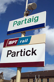
WPartick is an area of Glasgow on the north bank of the River Clyde, just across from Govan. To the west lies Whiteinch, to the east Yorkhill and Kelvingrove Park, and to the north Broomhill, Hyndland, Dowanhill, Hillhead, areas which form part of the West End of Glasgow. Partick was a Police burgh from 1852 until 1912 when it was incorporated into the city. Partick is the area of the city most connected with the Highlands, and several Gaelic agencies, such as the Gaelic Books Council are located in the area. Some ATMs in the area display Gaelic.
 W
WPenicuik is a town and former burgh in Midlothian, Scotland, lying on the west bank of the River North Esk. It lies on the A701 midway between Edinburgh and Peebles, east of the Pentland Hills.
 W
WPollokshaws is an area on the South side of the city of Glasgow, Scotland. It is bordered by the residential neighbourhoods of Auldhouse to the east, Eastwood and Hillpark to the south and Shawlands to the north, with the Glasgow South Western Line railway and the open lands of Pollok Country Park to the west. The White Cart Water flows through the area.
 W
WPollokshields is an area in the Southside of Glasgow, Scotland. Its modern boundaries are largely man-made, being formed by the M77 motorway to the west and northwest with the open land of Pollok Country Park and the Dumbreck neighbourhood beyond, by the Inverclyde Line railway and other branches which separate its territory from the largely industrial areas of Kinning Park, Kingston and Port Eglinton, and by the Glasgow South Western Line running from the east to south, bordering Govanhill, Strathbungo, Crossmyloof and Shawlands residential areas. There is also a suburban railway running through the area.
 W
WPortobello is a coastal suburb of Edinburgh in eastern central Scotland. It lies three miles (5 km) to the east of the city centre, facing the Firth of Forth, between the suburbs of Joppa and Craigentinny. Although historically it was a town in its own right, it is officially a residential suburb of Edinburgh. The promenade fronts onto a wide sandy beach.
 W
WPortsoy is a town in Aberdeenshire, Scotland.
 W
WA tolbooth or town house was the main municipal building of a Scottish burgh, from medieval times until the 19th century. The tolbooth usually provided a council meeting chamber, a court house and a jail. The tolbooth was one of three essential features in a Scottish burgh, along with the mercat cross and the kirk (church).
 W
WWishaw is a post-industrial large town in North Lanarkshire, Scotland, on the edge of the Clyde Valley, 15 miles (24 km) south-east of Glasgow city centre. The Burgh of Wishaw was formed in 1855; it formed a joint large burgh with its neighbour Motherwell from 1920 until its dissolution when Scottish local authorities were restructured in 1975. The town is part of the Motherwell and Wishaw constituency. It is one of the principal towns of Lanarkshire and has the postal code of ML2 and the dialling code 01698.
 W
WWoodside is part of the city of Aberdeen. It came into existence as a quoad sacra parish within the parish of Old Machar in 1834, under an act of The General Assembly of the Church of Scotland of 31 May 1834, and was named for the principal residence of the area, Woodside House.