 W
WThe Argentina–Chile border is the longest international border of South America and the third longest in the world after the Canada–United States border and the Kazakhstan–Russia border. With a length of 5,308 kilometres (3,298 mi), it separates Argentina from Chile along the Andes and on the islands of Tierra del Fuego. However, there are some border disputes, particularly around the Southern Patagonian Ice Field.
 W
WThe 52nd parallel south is a circle of latitude that is 52 degrees south of the Earth's equatorial plane. It crosses the Atlantic Ocean, the Indian Ocean, the Pacific Ocean and South America.
 W
WThe schooner Ancud was the ship sent by Chile in 1843 to claim sovereignty over the Strait of Magellan. It was built for the purpose in the city of San Carlos de Ancud and commanded by John Williams Wilson a British born Chilean captain.
 W
WCerro Bayo is a complex volcano on the northern part border between Argentina and Chile. It consists of four overlapping stratovolcanoes along a north–south line. The main volcano fauce is located on the Argentine side, thought the summit of the complex is just west of the border, in Chile. The volcano is about 800,000 years old, but it is associated with ongoing ground uplift encompassing also the more northerly Lastarria and Cordón del Azufre volcanoes. The 5,401-metre (17,720 ft) high summit is the source of two viscous dacitic lava flows with prominent levees that traveled to the north. In 2007 a steam eruption were observed by researchers investigating nearby salt pans.
 W
WBeagle Channel is a strait in Tierra del Fuego Archipelago on the extreme southern tip of South America between Chile and Argentina. The channel separates the larger main island of Isla Grande de Tierra del Fuego from various smaller islands including the islands of Picton, Lennox and Nueva; Navarino; Hoste; Londonderry; and Stewart. The channel's eastern area forms part of the border between Chile and Argentina and the western area is entirely within Chile.
 W
WThe Boundary Treaty of 1881 between Argentina and Chile was signed on the 23 July 1881 in Buenos Aires by Bernardo de Irigoyen, on the part of Argentina, and Francisco de Borja Echeverría, on the part of Chile, with the aim of establishing a precise and exact borderline between the two countries based on the uti possidetis juris principle. Despite dividing largely unexplored lands, the treaty laid the groundwork for nearly all of Chile's and Argentina's current 5600 km shared border.
 W
WGeneral Carrera Lake or Lake Buenos Aires is a lake located in Patagonia and shared by Argentina and Chile. Both names are internationally accepted.
 W
WFagnano Lake, also called Lake Cami, is a lake located on the main island of the Tierra del Fuego archipelago, and shared by Argentina and Chile.
 W
WThe Casuchas del Rey or Casuchas de la Cordillera are a string of small mountain shelters made of stone masonry along the route of the Uspallata Pass of the Principal Cordillera in the Andes of Chile and Argentina. The shelters were built to improve the intra-colonial postal system of the Spanish Empire.
 W
WCerro Agassiz is a mountain in the mountain range of the Andes, located in the border between Argentina and Chile, in the region of Patagonia.
 W
WCerro Aguja Sur is a mountain in the mountain range of the Andes, located in the Chubut Province of Argentina and Los Lagos Region of Chile. It is 2298 meters high, forming one of the majors elevations of the zone, and thus also one of the end points of the province of Chubut.
WCerro El Toro is a mountain in the Andes located on the border between Argentina and Chile. It has an elevation of 6,168 m above sea level.
 W
WCerro Las Tórtolas is a mountain in the Andes Mountains, on the border between Argentina and Chile. It has a height of 6,160 metres (20,210 ft).
 W
WCerro Murallón is a glacier mountain of the Andes, in Patagonia, located on the eastern edge of the Southern Patagonian Ice Field, southwest of Lake Viedma, at the border between Chile and Argentina.
WCerro Piergiorgio is a mountain in Los Glaciares National Park in province of Santa Cruz in Patagonia, near the village of El Chaltén, at the border between Argentina and Chile. Its altitude is 2719 m.
 W
WCopahue is a stratovolcano in the Andes on the border of Bío Bío Region, Chile and Neuquén Province, Argentina. There are nine volcanic craters along a 2 km (1.2 mi) line, the easternmost of which is historically the most active, and contains a 300 m (1000 ft) wide crater lake with a pH ranging between 0.18 and 0.30. Eruptions from this crater lake have ejected pyroclastic rocks and chilled liquid sulfur fragments. Although the lake emptied during the 2000 eruption, it later returned to its previous levels. Copahue means "sulphur waters" in Mapuche.
 W
WThe Cordillera of the Andes Boundary Case was a British arbitration in 1902 that established the present day boundaries between Argentina and Chile. In northern and central Patagonia, the borders were established between the latitudes of 40° and 52° S as an interpretation of the Boundary treaty of 1881 between Chile and Argentina.
 W
WCordón del Azufre is a small, inactive complex volcano located in the Central Andes, at the border of Argentina and Chile. The centre contains a series of craters and lava flows covering a surface area of 60 square kilometres (23 sq mi). A western component with four craters aligned in a north–south direction on a 5-kilometre-long (3.1 mi) ridge forms the oldest part. The eastern component is formed by lava flows and craters in Argentina, and the youngest part la Moyra volcano in the western component generated a lava flow that advanced 6 kilometres (3.7 mi) westwards. Weakly porphyritic Andesite and dacite form the rocks of the volcano. No activity, including fumarolic activity, has been recorded at Cordón del Azufre, but the appearance and radiometric age of the lava flows suggest a recent age.
 W
WDickson Lake is a glacier lake in southern Patagonia located in the Southern Patagonian Ice Field, which since 1998 has been transformed into an international lake as it is crossed by the international boundary between Argentina and Chile due to the retreat of the Dickson glacier. Until that year, Dickson Lake was entirely within Chilean territory, at the northern end of the Torres del Paine National Park in the Magallanes y la Antártica Chilena Region, but it was unified with a lake that began to form in the 1980s by defrosting the melting of the Dickson, Cubo and Frías glaciers. That lake was on the Argentine side when the Agreement was signed to specify the route of the limit from Mount Fitz Roy to the Daudet Hill of 1998, in a sector adjacent to the Los Glaciares National Park, but without being part of it. The lake is fed by the glacier that shares its name and is drained by the Paine River. It receives the waters of Los Perros River, which starts at a proglacial lake that was formed during the retreat of Los Perros Glacier.
 W
WThe El Indio Gold Belt is a mineral-rich region spanning the border between Chile and Argentina that contains large quantities of gold, silver and copper. On both sides of the border the belt is located within the Andes. The El Indio mine within the district was the first modern mine in Chile to produce gold as its main product. In Chile the main precious metal containing mineral is enargite. The El Indio belt is bordered in the north by another gold-silver mining district known as the Frontera District. Rodalquilarite, alunite and poughite are some of the minerals present in the area. The deposits of the belt formed during the Late Miocene period.
 W
WCerro Escorial is a stratovolcano at the border of Argentina and Chile. It is part of the Corrida de Cori volcanic group and its youngest member. A well-preserved 1-kilometre-wide (0.6 mi) crater forms its summit area. Lava flows are found on the Chilean and smaller ones on the Argentinian side, the former reaching as far as 3–4 kilometres (1.9–2.5 mi) from the volcano. One of these is dated 342,000 years ago by argon-argon dating.
 W
WEspíritu Santo Cape is a headland in Tierra del Fuego at the eastern entrance of the Strait of Magellan on its southern, opposite Punta Dungeness in the mainland. Espíritu Santo Cape marks the border between Chile and Argentina, and according to the Treaty of Peace and Friendship of 1984 between Chile and Argentina the line between Punta Dungeness and Cabo del Espiritu Santo marks the limits of each country's territorial waters.
 W
WFalso Azufre is a complex volcano at the border of Argentina and Chile.
 W
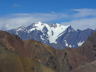
WMonte Fitz Roy is a mountain in Patagonia, on the border between Argentina and Chile. It is located in the Southern Patagonian Ice Field, near El Chaltén village and Viedma lake. It was first climbed in 1952 by French alpinists Lionel Terray and Guido Magnone.
 W
WThe Futaleufú River, located in northern Patagonia, is one of the premier whitewater rivers in the world. One of only two rivers to cross the 5,308 kilometer Chile-Argentina border, the Futaleufú headwaters can be found in the glacial snow melt of the UNESCO protected Los Alerces National Park in Argentina. The river gorge drops as low as 1,700 metres (5,600 ft) below the surrounding glaciated peaks. The name Futaleufú is an indigenous Mapuche word meaning "Big River.” Locals refer to the valley as "un paisaje pintado por Dios"—a landscape painted by God.
WGeneral Carrera Lake or Lake Buenos Aires is a lake located in Patagonia and shared by Argentina and Chile. Both names are internationally accepted.
 W
WIncahuasi is a volcanic mountain in the Andes of South America. It lies on the border of the Catamarca Province of Argentina and the Atacama Region of Chile. Incahuasi has a summit elevation of 6,621 metres (21,722 ft) above sea level.
WIsla Grande de Tierra del Fuego also formerly Isla de Xátiva is an island near the southern tip of South America from which it is separated by the Strait of Magellan. The western portion (61.4%) of the island is in Chile, while the eastern portion is in Argentina. It forms the major landmass in an extended group of islands or archipelago also known as Tierra del Fuego.
 W
W W
WSierra Nevada, also known as Sierra Nevada de Lagunas Bravas, is a major ignimbrite-lava dome complex which lies in both Chile and Argentina in one of the most remote parts of the Central Andes. Activity in the complex started in Argentina and formed two stratovolcanoes. Later, 12 or more vents formed, some with craters up to 400 metres (1,300 ft) wide. Lava flows up to 7 kilometres (4.3 mi) long with flow ridges are also found. It covers a total area of 225 km². Radiometric dating has yielded ages of 1.7 ± 0.4 to 0.431 ± 0.012 million years ago. Together with Cerro el Condor and Peinado it forms the Culampaja line, a line of volcanoes that reaches Cerro Blanco. Strong seismic attenuation is observed beneath Sierra Nevada. Hydrothermally altered rocks in Sierra Nevada may be the source of sulfate and As in the Juncalito and Negro rivers.
 W
WLanín is an ice-clad, cone-shaped stratovolcano on the border of Argentina and Chile. It forms part of two national parks: Lanín in Argentina and Villarrica in Chile. It is a symbol of the Argentine province of Neuquén, being part of its flag and its anthem. Although the date of its last eruption is not known, it is estimated to have occurred within the last 10,000 years. Following the 1906 Valparaíso earthquake a local newspaper reported the volcano to have erupted, but a work published in 1917 by Karl Sapper disputed this.
 W
WLastarria is a stratovolcano that lies on the border between Chile and Argentina. It is part of the Central Volcanic Zone, one of the four segments of the volcanic arc of the Andes. Several volcanoes are located in this chain of volcanoes, which is formed by subduction of the Nazca Plate beneath the South American Plate.
 W
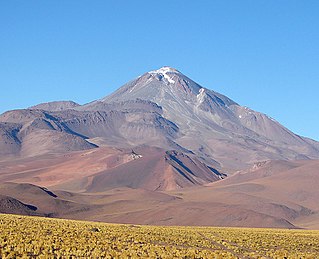
WLlullaillaco is a dormant stratovolcano at the border of Argentina and Chile. It lies in the Puna de Atacama, a region of tall volcanic peaks on a high plateau close to the Atacama Desert, one of the driest places in the world. It is the second highest active volcano in the world after Ojos del Salado.
 W
WMaipo is a stratovolcano in the Andes, lying on the border between Argentina and Chile. It is located 90 km (56 mi) south of Tupungato and about 100 km (62 mi) southeast of Santiago. It has a symmetrical, conical volcanic shape, and is among the southernmost 5,000 metre peaks in the Andes.
 W
W W
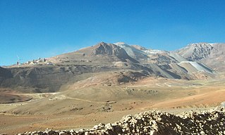
WNevado Ojos del Salado is an active stratovolcano in the Andes on the Argentina–Chile border and the highest active volcano in the world at 6,893 m (22,615 ft). It is also the second highest mountain in both the Western Hemisphere and the Southern Hemisphere behind Aconcagua at approximately 7,000 meters and it is the highest in Chile. Nevado Ojos del Salado could be translated as "Eyes of the Salty One", which describes it as being very snowy in the winter and salty with many lakes.
 W
WPali-Aike volcanic field is a volcanic field in Argentina which straddles the border with Chile. It is part of a province of back-arc volcanoes in Patagonia, which formed from processes involving the collision of the Chile Rise with the Peru–Chile Trench. It lies farther east than the Austral Volcanic Zone, the volcanic arc which forms the Andean Volcanic Belt at this latitude.
 W
WPascua-Lama is an open pit mining project of gold, silver, copper and other minerals. Pascua Lama is located in the Andes mountains, in the southern reaches of Atacama Desert, straddling the border between Chile and Argentina at an altitude of over 4,500 metres. Toronto-based Barrick Gold, the world's largest gold mining company, is developing the project. Due to its proximity to glaciers, Pascua-Lama has caused controversy and public protest in Chile, including demonstrations and petitions presented to the Chilean government. Chile has not approved the project.
 W
WPatagonia is a sparsely populated region at the southern end of South America, governed by Argentina and Chile. The region comprises the southern section of the Andes Mountains, lakes, fjords, and glaciers in the west and deserts, tablelands and steppes to the east. Patagonia is bounded by the Pacific Ocean on the west, the Atlantic Ocean to the east, and many bodies of water that connect them, such as the Strait of Magellan, the Beagle Channel, and the Drake Passage to the south.
 W
WPlanchón-Peteroa is a complex volcano extending in a north-south direction along the border between Argentina and Chile. It consists of volcanoes of various ages with several overlapping calderas. Those include Volcán Planchón, Volcán Peteroa and Volcán Azufre.
 W
WNevado del Plomo, also spelled as Nevado El Plomo, is a mountain located on the border between Argentina and Chile. Juncal Sur Glacier, which feeds the Olivares River, skirts the western side of the mountain.
 W
WPrincipal Cordillera is the Andean mountain range that makes up the boundary between Central Chile and neighbouring areas of Argentina. It is also a continental divide between the Atlantic and the Pacific watersheds. It extends in a north-south direction in the Argentine provinces of La Rioja, San Juan and Mendoza and the Chilean regions of Valparaíso, Santiago, O'Higgins and Maule. To the east of the Principal Cordillera lies the Frontal Cordillera which is fully in Argentina. Aconcagua, the tallest mountain outside Asia, lies in the Principal Cordillera.
 W
WThe Puna de Atacama dispute, sometimes referred to as Puna de Atacama Lawsuit, was a border dispute involving Argentina, Chile and Bolivia in the 19th century over the arid high plateau of Puna de Atacama located about 4500 meters above the sea around the current borders of the three countries.
 W
WPunta Dúngeness is a headland at the eastern entrance of the Strait of Magellan on its north shore, opposite Cabo del Espiritu Santo in Tierra del Fuego. West of the Punta Dungeness lies the Bahía Posesión. Punta Dungeness marks the border between Chile and Argentina, and according to the Treaty of Peace and Friendship the line between Punta Dungeness and Cabo del Espiritu Santo marks the limits of each country's territorial waters and the border between the Pacific and Atlantic Ocean. It is the southernmost point on the mainland of Argentina, and the easternmost point on the mainland of Chile. There is a lighthouse on the Chilean side. This is the only place where the Atlantic Ocean touches the shores on the mainland of Chile, at the entrance to the Strait of Magellan.
 W
WMonte San Lorenzo, also known as Monte Cochrane, is a mountain on the border between Argentina and Chile in Patagonia, reaching a height of 3,706 metres (12,159 ft). The Chilean name of Cochrane comes from the nearby town of Cochrane where climbers often approach the mountain. The peak was first climbed by Alberto María de Agostini in 1943.
 W
WSierra de Sangra is an extinct ice-clad stratovolcano with its summit located 10 km east of Villa O'Higgins. The volcanic masiff is heavily eroded and constitutes part of the Argentine-Chilean border in Patagonia.
 W
WSierra Baguales or Sierra de los Baguales is a mountain range in the southernmost Andes. Sierra Baguales is a 60 kilometres (37 mi) long east-west chain, secondary to the main chain of the Andes that lie further west. It lies along the border between Chile and Argentina near the localities of Puerto Natales and Río Turbio.
 W
WSocompa is a large stratovolcano at the border of Argentina and Chile. Part of the Chilean and Argentine Andean Volcanic Belt (AVB), it is part of the Central Volcanic Zone, one of the various segments of the AVB. This part of the Andean volcanic arc begins in Peru and runs first through Bolivia and Chile, and then through Argentina and Chile, and contains about 44 active volcanoes. Socompa lies close to the pass of the same name, where the Salta-Antofagasta railway crosses the border.
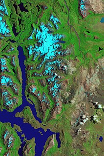
WThe Southern Patagonian Ice Field, located at the Southern Patagonic Andes between Chile and Argentina, is the world's second largest contiguous extrapolar ice field. It is the bigger of two remnant parts of the Patagonian Ice Sheet, which covered all of southern Chile during the last glacial period, locally called the Llanquihue glaciation.
 W
WNevado Tres Cruces is a massif of volcanic origin in the Andes Mountains on the border of Argentina and Chile. It has two main summits, Tres Cruces Sur at 6,748 metres (22,139 ft) and Tres Cruces Centro at 6,629 m (21,749 ft) and a third more minor summit, Tres Cruces Norte 6,206 m (20,361 ft). Tres Cruces Sur is the sixth highest mountain in the Andes. The area was first surveyed in 1883 by Francisco San Román and the Nevado Tres Cruces National Park was established in 1994.
 W
WTronador is an extinct stratovolcano in the southern Andes, located along the border between Argentina and Chile, near the Argentine city of Bariloche. The mountain was named Tronador by locals in reference to the sound of falling seracs. With an altitude of 3,470 metres (11,380 ft), Tronador stands more than 1,000 m above nearby mountains in the Andean massif, making it a popular mountaineering destination. Located inside two national parks, Nahuel Huapi in Argentina and Vicente Pérez Rosales in Chile, Tronador hosts a total of eight glaciers, which are currently retreating due to warming of the upper troposphere.
 W
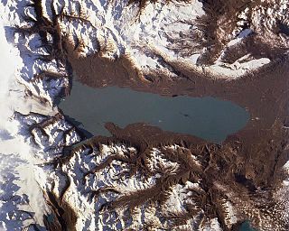
WViedma Lake, approximately 50 miles long in southern Patagonia near the border between Chile and Argentina. It's a major elongated trough lake formed from melting glacial ice. Viedma Lake is the second largest lake in Argentina.
 W
WVintter Lake or Palena Lake is a lake located in Patagonia which is shared by Argentina, where it is known as Lago General Vintter, and by Chile, where it's called Lago Palena. Both names are internationally accepted. The Argentine name is after General Lorenzo Vintter, the second governor of the Argentine Territory of Patagonia (1882–1884), and the first governor of the Territory of the Río Negro (1884–1888).
 W
WZapaleri is a volcano whose summit is the tripoint of the borders of Argentina, Bolivia and Chile. A number of railways are in the area. It is part of Potosí Department (Bolivia), Jujuy Province (Argentina), and Antofagasta Region (Chile). The volcano formed on top of the 2.89 mya Tara Ignimbrite from the Guacha caldera and the basement beneath the volcano is formed from Cretaceous and Tertiary rocks affected by tectonic deformation. Volcanic rocks are andesite, basalt, dacite and rhyolite. Late Cretaceous rocks are also found in the area, as are Pleistocene shoshonite volcanic rocks.