 W
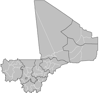
WA cercle is the second level administrative unit in Mali. Mali is divided into eight régions and one capital district (Bamako); the régions are subdivided into 49 cercles. These subdivisions bear the name of their principal city.
 W
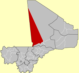
WAbeïbara Cercle is an administrative subdivision of the Kidal Region of north-eastern Mali. The capital lies at the small town of Abeïbara. The Cercle is divided into Communes, and below this, quarters/villages. As of 2009 the cercle had a population of 10,286.
 W
WAndéramboukane is a town and cercle in Ménaka Region, Mali. It lies at the extreme east of the country, several kilometers north of the Nigerien border. It was previously a commune in Ménaka Cercle but was promoted to the status of a cercle when Ménaka Region was implemented in 2016.
 W
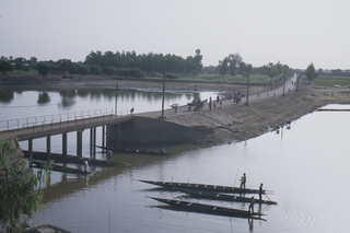
WAnsongo Cercle is an administrative subdivision of the Gao Region of Mali. The administrative center (chef-lieu) is the town of Ansongo. The Niger River passes through the cercle and plays an important role in transportation and the economy in the region.
 W
WBafoulabé Cercle is an administrative subdivision of the Kayes Region of Mali. The administrative center (chef-lieu) is the town of Bafoulabé. In the 2009 census the population of the cercle was 233,926.
 W
WBamako is the capital and largest city of Mali, with a 2009 population of 1,810,366. In 2006, it was estimated to be the fastest-growing city in Africa and sixth-fastest in the world. It is located on the Niger River, near the rapids that divide the upper and middle Niger valleys in the southwestern part of the country.
 W
WBanamba Cercle is an administrative subdivision of the Koulikoro Region of Mali. Its seat is the town of Banamba, which is also its largest settlement. It lies at the center east of the region.
 W
WBandiagara Cercle is an administrative subdivision of the Mopti Region of Mali. The administrative center (chef-lieu) is the town of Bandiagara.
 W
WBankass Cercle is an administrative subdivision of the Mopti Region of Mali. The administrative center (chef-lieu) is at the town of Bankass.
 W
WBarouéli Cercle is an administrative subdivision of the Ségou Region of Mali. The administrative center (chef-lieu) is the town of Barouéli.
 W
WBla Cercle is an administrative subdivision of the Ségou Region of Mali. The administrative center (chef-lieu) is the town of Bla.
 W
WBougouni Cercle is an administrative subdivision of the Sikasso Region of Mali. The administrative center (chef-lieu) is the town of Bougouni.
 W
WBourem Cercle is an administrative subdivision of the Gao Region of north-eastern Mali. The administrative center (chef-lieu) is the town of Bourem.
 W
WDiéma Cercle is an administrative subdivision of the Kayes Region of Mali. Its administrative center (chef-lieu) is the small town of Diéma. The Cercle is divided into one urban commune and fourteen rural communes. In the 2009 census the cercle had a population of 212,062.
 W
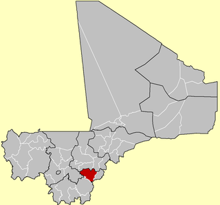
WDioïla Cercle is an administrative subdivision of the Koulikoro Region of Mali. Its seat is the town of Dioïla. It lies at the southeast corner of the region, and prior to 1977, it was combined with what is now Kati Cercle and the District of Bamako in the "Bamako Cercle", with the capital city as its seat.
 W
WDiré Cercle is an administrative subdivision of the Tombouctou Region of Mali. The administrative center (chef-lieu) is the town of Diré.
 W
WDjenné Cercle is an administrative subdivision of the Mopti Region of Mali. The administrative center (chef-lieu) is the town of Djenné. In the 2009 census the cercle had a population of 207,260 people.
 W
WDouentza Cercle is an administrative subdivision of the Mopti Region of Mali. The administrative center (chef-lieu) is the town of Douentza.
 W
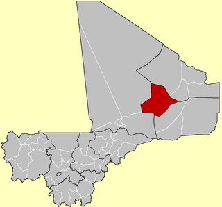
WGao Cercle is an administrative subdivision of the Gao Region of north-eastern Mali. The administrative center (chef-lieu) is the town of Gao.
 W
WGoundam Circle is a second-level administrative subdivision of the Tombouctou Region in northern Mali. Its administrative center is the town of Goundam, although the most populous commune is that of Tonka. In the 2009 census, the circle had a population of 150,150.
 W
WGourma-Rharous Cercle is an administrative subdivision of the Tombouctou Region of Mali. The administrative center is the town of Gourma-Rharous.
WInékar is a village and cercle of Ménaka Region in southeastern Mali. It has an area of approximately 27,000 square kilometers and in 2009 had a population of 8,714. It was previously a commune in Ménaka Cercle but was promoted to the status of a cercle when Ménaka Region was implemented in 2016.
 W
WKadiolo Cercle is an administrative subdivision of the Sikasso Region of southern Mali. The administrative center (chef-lieu) is the town of Kadiolo.
 W
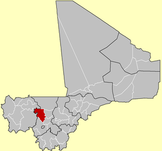
WThe Kangaba Cercle is an administrative subdivision of the Koulikoro Region of Mali. Its seat is the town and commune of Benkadi Habaladougou (Kenieba), also known as Kangaba. It lies at the southwest corner of the region, along the Guinean border, with the Niger River forming its southern edge.
 W
WKati Cercle is an administrative subdivision of the Koulikoro Region of Mali. Its seat is the town of Kati, which is also its largest town. It lies at the southwest corner of the region, and completely surrounds the Bamako Capital District. Until the capital was hived off in 1977, the combined Cercle was called Bamako Cercle, with the capital city as its seat.
 W
WKayes Cercle is an administrative subdivision of the Kayes Region of Mali. Its seat is the city of Kayes, which is also the capital of its Region and its largest city. The Cercle is further divided into Communes. The city of Kayes is subdivided into Urban Communes and Wards. Kayes Cercle's population in 2009 was 513,362.
 W
WKéniéba Cercle is a subdivision of the Kayes Region of Mali. The administrative center (chef-lieu) is the town of Kéniéba.
 W
WKidal Cercle is an administrative subdivision of the Kidal Region of Mali. The administrative center (chef-lieu) is the town of Kidal. The cercle is divided into rural and urban communes, and below this, quarters/villages. In 2009 the cercle had a population of 33,087.
 W
WKita Cercle is an administrative subdivision of the Kayes Region of Mali. The administrative centre (chef-lieu) is the town of Kita. In the 2009 census the population of the cercle was 434,379.
 W
WKolokani Cercle is an administrative subdivision of the Koulikoro Region of Mali. Its seat is the town of Kolokani, which is also its largest settlement. It lies directly to the north of Kati Cercle. Also to the south, is the District of Bamako, which after independence was carved out of the middle of the Region. The cercle is further divided into communes.
 W
WKolondiéba Cercle is an administrative subdivision of the Sikasso Region of Mali. The administrative center (chef-lieu) is the town of Kolondiéba.
 W
WKoro Cercle is an administrative subdivision of the Mopti Region of Mali. The administrative center is the town of Koro.
 W
WKoulikoro Cercle is an administrative subdivision of the Koulikoro Region of Mali. Its seat is the town of Koulikoro, which is also the capital of the region. A major trade and industrial town on the Niger River, Koulikoro has been surpassed by Kati to the west as the largest town in the region. Also to the southwest, lying entirely within Kati Cercle but administratively separate, is the District of Bamako, which after independence was carved out of the middle of the region.
 W
WKoutiala Cercle is an administrative subdivision of the Sikasso Region of southern Mali. The administrative center is the town of Koutiala. The Cercle is divided into 36 communes.
 W
WMacina Cercle is an administrative subdivision of the Ségou Region of Mali. The administrative center (chef-lieu) is the town of Macina.
 W
WMénaka Cercle is an administrative subdivision of Ménaka Region, Mali. Its administrative center is the town of Ménaka. Ménaka Cercle's population as of 2009 was 56,104 people. Ménaka is located in the middle of the Sahara Desert, along Wadi Ezgeuret and an ancient dry river valley of the Iullemmeden Basin. Its highest point, Mount Abourak, is located around 150 km to the north of the town of Ménaka. Most of the small population are nomadic Tuareg tribal populations; minorities include the Wodaabe Fula and sedentary Songhai people. The area is a traditional center of the Kel Dinnik Tuareg confederation, along with the town of Andéramboukane near the Nigerien border.
 W
WMopti Cercle is an administrative subdivision of the Mopti Region of Mali. The administrative center (chef-lieu) is the town of Mopti.
 W
WNara Cercle is an administrative subdivision of the Koulikoro Region of Mali. Its seat is the town of Nara.
 W
WNiafunké Cercle is an administrative subdivision of the Tombouctou Region of Mali. The administrative center (chef-lieu) is the town of Niafunké. In the 2009 census the cercle had a population of 184,285. The Niger River runs for 100 km through the cercle.
 W
WNiono Cercle is an administrative subdivision of the Ségou Region of Mali. The administrative center (chef-lieu) is the town of Niono.
 W
WNioro Cercle is an administrative subdivision of the Kayes Region of Mali. Its administrative center (chef-lieu) is the town of Nioro du Sahel. The commune is on the Mauritanian border and has long been a major stop on the trans-Saharan trade.
 W
WSan Cercle is an administrative subdivision of the Ségou Region of Mali. The administrative center (chef-lieu) is the town of San.
 W
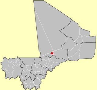
WSégou Cercle is an administrative subdivision of the Ségou Region of Mali. The administrative center (chef-lieu) is the town of Ségou.
 W
WSikasso Cercle is one of seven administrative subdivision of the Sikasso Region of southern Mali. The capital is the town of Sikasso.
 W
WTénenkou Cercle is an administrative subdivision of the Mopti Region of Mali. Its seat is the town of Ténenkou, which is also its largest town. The cercle is divided into communes.
 W
WTessalit Cercle is an administrative subdivision of the Kidal Region of Mali. The administrative centre is the village of Tessalit. The cercle is divided into communes, and below this, quarters/villages. As of 2009 the cercle had a population of 16,289.
WTidermène is a village and cercle in Ménaka Region of southeastern Mali. In the 2009 census it had a population of 5,816. Its area is approximately 29,000 square kilometers. It was previously a commune in Ménaka Cercle but was promoted to the status of a cercle when Ménaka Region was implemented in 2016. From 2001 to 2016 the commune of Alata was separated from Tidermène.
 W
WTimbuktu Cercle is an administrative subdivision of the Tombouctou Region of Mali. It is the largest cercle by area in the whole of Mali. The capital lies at the city of Timbuktu. The cercle is divided into Rural and Urban Communes, and below this, quarters/villages. In the 2009 census the cercle had a population of 124,546.
 W
WTin-Essako Cercle is an administrative subdivision of the Kidal Region of Mali. The administrative center (chef-lieu) is at the village of Tin-Essako. In the 2009 census the cercle had a population of 7,976 people. The cercle is the least populated in Mali and has an extreme Saharian climate.
 W
WTominian Cercle is an administrative subdivision of the Ségou Region of Mali. The administrative center of the local government is in the town of Tominian. The Cercle is divided into Communes, and below this, quarters/villages. In the 2009 census the cercle had a population of 219,853 people.
 W
WYanfolila Cercle is an administrative subdivision of the Sikasso Region of southern Mali. The administrative center (chef-lieu) is the town of Yanfolila.
 W
WYélimané Cercle is an administrative subdivision of the Kayes Region of Mali. Its administrative centre (chef-lieu) is the town of Yélimané. In the 2009 census the population of the cercle was 178,442.
 W
WYorosso Cercle is an administrative subdivision of the Sikasso Region of southern Mali. The main town (chef-lieu) is Yorosso.
 W
WYouwarou Cercle is an administrative subdivision of the Mopti Region of Mali. The administrative center (chef-lieu) is the town of Youwarou.