 W
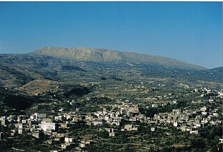
WAkkar al-Atika is a town and municipality located in the Akkar Governorate in northern Lebanon. It is about 135 kilometres (84 mi) north of Beirut. Akkar al-Atika contains the 11th-century fortress of Gibelacar, which was utilized by the Crusaders and became the headquarters of the Sayfa clan, whose members were chieftains and Ottoman governors of Tripoli and its districts in from the late 16th until the mid-17th centuries.
WArida is a village in northern Lebanon, on the Syrian border, which is formed by the mouth of the Nahr al-Kabir al-Janoubi. It is located in the Akkar District of the Akkar Governorate. Its inhabitants are Sunni Muslims. The Arida Border Crossing is the coastal border crossing between Lebanon and Syria.
WArqa (Arabic: عرقا; canaanite: Irqata also in phonecian is a Sunni village near Miniara in Akkar Governorate, Lebanon, 22 km northeast of Tripoli, near the coast.
WArsal, is a town and municipality situated east of Labweh, 124 kilometres (77 mi) northeast of Beirut, in Baalbek District of Baalbek-Hermel Governorate, Lebanon. The population is predominantly Sunni Muslim.
WAydamun is a Lebanese village.
 W
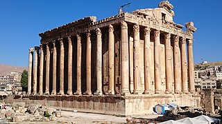
WBaalbek is a city located east of the Litani River in Lebanon's Beqaa Valley, about 67 km (42 mi) northeast of Beirut. It is the capital of Baalbek-Hermel Governorate. In Greek and Roman times Baalbek was also known as Heliopolis. In 1998 Baalbek had a population of 82,608, mostly Shia Muslims, followed by Sunni Muslims and Christians.
WBaaloul is a town located in the eastern Bekaa Valley of southeastern Lebanon.
WBakka, Bekka or Beka is a village and municipality situated 85 kilometres (53 mi) east of Beirut in the Rashaya District of the Beqaa Governorate in Lebanon. The population of the village is Sunni.
WBarelias, or Bar Elias, is a town located in the Zahlé District, Bekaa Governorate, Lebanon. With around 60,000 inhabitants it is the second largest town, after Zahlé, in the Zahlé District. Bar Elias is a village of the Bekaa Valley, the center of Bekaa. It is known widely by its transit passes, as it is halfway between Beirut and Damascus. As the distance between the center of the northern Bekaa and the south became important because of its central valleys and on the international line of the most important economic centers and the largest commercial markets, Bar Elias has good neighborly relations with the rest of the towns and villages in the province. Easily accessible from all directions and in the center of the Bekaa Valley, Bar Elias is an open gate to all guests and visitors.
WBarja is a town and municipality in the Chouf District of the Mount Lebanon Governorate in Lebanon. Barja is situated near the Mediterranean coast, 34 kilometers south of Beirut and at the midway point between the latter and Sidon. The town's total land area consists of 729 hectares and its highest point above sea level is documented at 310 meters. Barja had 12,888 registered voters in 2010, and eleven schools with a total of 2,788 students in 2006. Its inhabitants are predominantly Sunni Muslims.
WBebnine is a town located in the Akkar District of the Akkar Governorate in Lebanon. Its inhabitants are Sunni Muslims.
WBerqayel or Berkayel is one of the largest and the most historical towns in Akkar Governorate in northern Lebanon. Berkail is about 25 km north Tripoli. Berkail is well known by its olive production and green fields. It is a Sunni Muslim community.
WBouarij is a village located on the eastern side of the Church Mountain, Beqaa. The municipality of Bouarej is located in the Kaza of Zahleh one of Mohafazah of Beqaa kazas (districts), one of the eight mohafazats (governorates) of Lebanon.
 W
WBourj el-Barajneh is a municipality located in the southern suburbs of Beirut, in Lebanon. The municipality lies between Beirut–Rafic Hariri International Airport and the town of Haret Hreik.
WBsaba, also written as Bessaba, Bisaba, Bisābā, is a village in the Beirut, Lebanon. The population of Bsaba is mainly Christian.
WChekka is coastal town located in North Lebanon. It is located north of Râs ach-Chaq’a’ and Herri beaches, or Theoprosopon of classical times and south of the ancient Phoenician port of Enfeh and the city of Tripoli. The origin of the word is believed to be Canaanite from the word Chikitta. Chikitta was mentioned Amarna letters in Egypt as a coastal town situated in the geographical area of modern Chekka. Until now there are no Canaanite archeological findings in Chekka backing this hypothesis. Chekka's modern history is clear. The high land in Chekka now known as Chekka Al-Atika was resettled around 300 years ago and the fertile valley of Chekka was cultivated in the intention of making Chekka a Maronite stronghold on the Lebanese coast. Many families moved from Mount Lebanon to Chekka at that time.
 W
WDahieh is a predominantly Shia Muslim suburb composed of several towns and municipalities south of Beirut, located in the Baabda District of Lebanon. There is also a minority of coexisting Sunni Muslims, and a Palestinian refugee camp which has 20,000 inhabitants. It is located north of the Rafic Hariri International Airport, with the M51 Freeway that links Beirut to the Airport passing through it. Prior to the 2006 Israel-Lebanon conflict, Dahieh was a residential and commercial area with malls, stores and souks.
 W
WEjdabrine, Ejd Aabrine,, is a Sunni Muslim and Maronite Christian community in the Koura District of Lebanon. Both religions coexist peacefully. It is beautiful and lush, and the jaouz river surrounds it.
 W
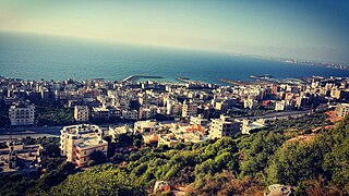
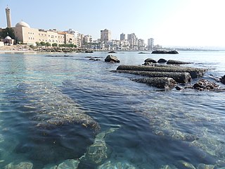
WEl-Mina or El Mina, is a coastal independent town in Tripoli, Northern Lebanon. El-Mina occupies the location of the old Phoenician city of Tripoli. It acts as the harbour city for modern neighbouring Tripoli, Lebanon's second-largest city, situated 5 km to the east.
WEnfeh, or Enfe, Anfeh, Anfe, is a town in the Koura district of the North Governorate of Lebanon at Latitude 34°21'0"N and Longitude 35°44'0"E. Enfeh borders the towns of Chekka, Al-Qalamoun, Barghoun and Zakroun. It is located 65 kilometres (40 mi) north of Beirut and 15 kilometres (9.3 mi) south of Tripoli. Its total area is 4.93 square kilometres (1.90 sq mi), and its population is around 6,500.
 W
WFakiha is a village in Baalbek-Hermel Governorate, Lebanon.
WFnaidek, Fnaydeq, is a village in Akkar Governorate, Lebanon. Its inhabitants are Sunni Muslims.
WHalba is the capital of Akkar Governorate in northern Lebanon, close to the border with Syria. It is located at around 34°33′2″N 36°4′41″E.
 W
WHebbariye, Hebbariyeh, Hebbariya or Hebariya is a village and municipality situated in the Hasbaya District of the Nabatieh Governorate in Lebanon. It is located on the southwestern slopes of Mount Hermon near the Syrian border, northeast of Rachaya Al Foukhar and is positioned amongst orchards of apricot trees.
 W
WHisah is a northern Lebanese village in Akkar Governorate, close to the Syrian border. It is mostly inhabited by Alawites and Sunni Muslims.
WIaal is a village in northern Lebanon.
 W
WJieh is a seaside town in Lebanon with an estimated population of 5000, 23 km south of Beirut, in the Chouf district via a 20-minute drive along the Beirut to Sidon highway south of the capital. In Phoenician times it was known as Porphyreon and was a thriving natural seaport, which still functions today. The town is also known for its seven kilometre sandy beach, a rarity along Lebanon's mainly rocky coastline.
 W
WKaferkahel and some says Kfarqahel is a Lebanese village of Al-Koura villages in the North governorate. Characterized by its geographical location as it separates the district of Al-Koura and Zagarta-corner through the valley Qadisha and the river Qadisha. The village is half Greek Orthodox Christian and half Sunni Muslim). There's a church (St.Georges) and a mosque in the center of the village and a little abandoned church on the banks of Qadisha river, this church is used in July to celebrate Mar Illiess.
 W
WKamid al lawz is located in West Bekaa, Lebanon. Its population numbers several thousand, mostly Sunni, people.
WKefraya is a village in the Western Beqaa District of the Beqaa Governorate in the Republic of Lebanon, approximately 7 kilometres (4.3 mi) northwest of Joub Jannine. The village is home to a mixed population of Sunnis and Greek Catholics.
WKfar Danis is a village in Lebanon, situated in Rashaya District, Beqaa Governorate. It is located north of Dahr El Ahmar. Kfar Danis is 78 kilometres (48 mi) away from the capital of Beirut.
WKfarhata is a village located in the Zgharta District in the North Governorate of Lebanon. It is a mixed Maronite Christian and Sunni Muslim community.
 W
WKherbet Rouha is a town in the Rashaya District of Lebanon. It lies in the Bekaa Valley, about 10 kilometres (6 mi) northwest of Mount Hermon. The town is known for having the largest mosque towers in Lebanon.
WKouachra is a village in Akkar Governorate, Lebanon. It is located approximately 131 kilometres (81 mi) north of Beirut and 38 kilometres (24 mi) north of Tripoli.
WLaqlouq, also spelled Laklouk and also known as ′Arab Laqlouq is a small mountainous village in mountainous area in the Byblos District of Mount Lebanon Governorate, Lebanon. It is located 69 kilometers northeast of Beirut. Laqlouq has an average elevation of 1,780 meters above sea level and a total land area of 210 hectares. Most of the inhabitants are Sunni Muslims, in contrast to the majority of Byblos District's population, which is largely Maronite Christian with a significant Shia Muslim minority.
 W
WMajdal Anjar is a village of Beqaa Governorate, Lebanon. Majdal Anjar is an overwhelmingly Sunni Muslim town.
WManara, also known as Hammara, is a municipality in the West Beqaa district of the Beqaa Governorate in eastern Lebanon. It is located approximately 65 kilometers (40 mi) east of the capital Beirut. Its average elevation is 1,160 meters (3,810 ft) above sea level and its jurisdiction covers 1,413 hectares. Its inhabitants are Sunni Muslims.
WMarjayoun, also Marj 'Ayoun, Marjuyun or Marjeyoun and Jdeideh / Jdeida / Jdeidet Marjeyoun, a Lebanese town and an administrative district, the Marjeyoun District, in the Nabatieh Governorate in Southern Lebanon.
WMarwahin is a town in Lebanon, on its border with Israel. A group of 23 residents, mostly children, were killed by Israel during the 2006 Lebanon War while attempting to evacuate under Israeli orders.
 W
WMassoudieh is a village in Akkar Governorate, Lebanon, inhabited by Alawites.
 W
WMdoukha is a village and municipality situated 72 kilometres (45 mi) east of Beirut in the Rashaya District, Beqaa Governorate, Lebanon. The village's population is Sunni. A significant majority of the population are also Lebanese Canadians, of which 60% live in London, Ontario.
 W
WMish Mish, also spelled Michmich, is a village located in Akkar Governorate, Lebanon. Mish Mish is situated 1100 metres above sea level in the mountainous terrain of the north. The closest major city to the village is Tripoli 45 km to the west; the Lebanese capital Beirut is 129 km to the southwest.
 W
WQabb Ilyas also spelled Kab Elias, Qab Elias, Qob Elias, Qoub Elias) is a municipality in Zahle District, in eastern Lebanon. Qabb Ilyas is 15 kilometers from Zahleh and 45 kilometers from the Lebanese capital Beirut. Its average elevations is 950 meters above sea level. Its area is approximately 32 km². Qabb Ilyas is the third largest city in the Beqaa Valley, after Zahleh and Baalbek in terms of area size and geography. The majority of the residents are Sunni Muslims.
 W
WAl-Qalamoun is a Mediterranean seaside town of the North Governorate of Lebanon in the Tripoli District. The town is 5 km south of Tripoli and is also the first town south of Tripoli.
 W
WQarsita is a Sunni Muslim village located in the highest mountains of Miniyeh-Danniyeh District in North Lebanon. The name of this village is derived from the two Arabic words "Qar" and "Sita" which mean famous ("sita") for cold ("Qar"). The village is famous for cultivation of pears, apples, peaches and variety of fruits and is one of the first producers of pears and apples in Lebanon. The very cold village, in comparison with surrounded areas, is characterized by its nature scenery and its unique position overlooking the city of Tripoli, the towns of Akkar district and the Syrian coast. Qarsita is one of the rich village in fresh water in Miniyeh-Danniyeh District, it contains thousandth of fresh water sources, the biggest one called Source of Sugar feeds a large number of villages in the area.
 W
WAl-Rafid is a village in the Rashaya District, in the southeastern area of the Beqaa Governorate in Lebanon. Its population is estimated to be 3,000. Its inhabitants are predominantly Sunni Muslims. The village has two mosques, two schools, two pharmacies, and a telecommunications facility.
WRas Maska is a village located in the Tripoli District in the North Governorate of Lebanon.
WRas Nhash is a town and municipality located in the Batroun District of the Tripoli Governorate in northern Lebanon. It is about 65 kilometres (40 mi) north of Beirut. It has an average elevation of 300 metres (980 ft) above sea level and a total land area of 383 hectares. It is located immediately north of the Chekka cape. Ras Nhash's inhabitants are Sunni Muslims.
WSaadnayel is a town in the Bekaa Valley in the Zahlé District of Lebanon. It has a population of around 52,500, mostly Sunnis.
WShhiim alternatively written as Shheem or Chhim/Chhîm is a town in Lebanon which is located 42 kilometres south-east of Beirut. Shhiim is located on 4 mountains in the Chouf region in lebanon. Chhim has a population of about 49,000. It is considered a city by some.
 W
WSidon, known locally as Sayda or Saida, is the third-largest city in Lebanon. It is located in the South Governorate, of which it is the capital, on the Mediterranean coast. Tyre to the south and Lebanese capital Beirut to the north are both about 40 kilometres away. Sidon has a population of about 80,000 within city limits, while its metropolitan area has more than a quarter-million inhabitants.
WTfail is a village in eastern Baalbek District, Baalbek-Hermel Governorate, Lebanon. It is one of the highest villages in Lebanon. It has a population of about 3,000 Sunni residents and is the most remote village in Lebanon, lying at the tip of a finger of territory that juts into Syria.
 W
WTripoli is the largest city in northern Lebanon and the second-largest city in the country. Situated 85 kilometers north of the capital Beirut, it is the capital of the North Governorate and the Tripoli District. Tripoli overlooks the eastern Mediterranean Sea, and it is the northernmost seaport in Lebanon. It holds a string of four small islands offshore, and they are also the only islands in Lebanon. The Palm Islands were declared a protected area because of their status of haven for endangered loggerhead turtles, rare monk seals and migratory birds. Tripoli borders the city of El Mina, the port of the Tripoli District, which it is geographically conjoined with to form the greater Tripoli conurbation.
 W
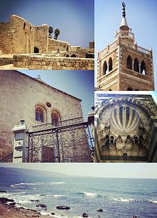
WTyre is one of the oldest continually inhabited cities in the world, though in medieval times for some centuries by just a tiny population. It was one of the earliest Phoenician metropolises and the legendary birthplace of Europa, her brothers Cadmus and Phoenix, as well as Carthage's founder Dido (Elissa). The city has many ancient sites, including the Tyre Hippodrome, and was added as a whole to UNESCO's list of World Heritage Sites in 1984. The historian Ernest Renan noted that "One can call Tyre a city of ruins, built out of ruins".