 W
WAizawl district is one of the eleven districts of Mizoram state in India. The district is bounded on the north by Kolasib district, on the west by Mamit district, on the south by Serchhip district, on the southwest by Lunglei district and on the east by Champhai district. The district occupies an area of 3,577 square kilometres (1,381 sq mi). The headquarters of the district is Aizawl city, the capital of Mizoram. As of 2011 it is the most populous district of Mizoram.
 W
WBairabi is a census town in Kolasib district in the state of Mizoram, India. It is also the railhead of Mizoram, 117 km from the Capital, Aizawl.
WBiate is a census town in Serchhip district in the state of Mizoram, India. Biate town has been selected as the cleanest town in Mizoram and Northeast.
 W
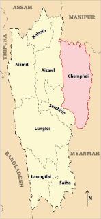
WChamphai district is one of the eleven districts of Mizoram state in India. The district is bounded on the north by Churachandpur district of Manipur state, on the west by Saitual and Serchhip districts, and on the south and east by Myanmar. The district occupies an area of 3185.83 km². Champhai town is the administrative headquarters of the district.
 W
W′
WDarlawn is a census town in Aizawl district in the state of Mizoram, India.
WDungtláng is an Indian village within Khawbung rural development block in Champhai district, Mizoram.
WHliappui S is a village in the Champhai district of Mizoram, India. It is located in the Ngopa R.D. Block.
WHmawngbuchhuah is a village in Lawngtlai Block in Lawngtlai district in the state of Mizoram, India.
WHnahthial is the headquarters of Hnahthial district in the Indian state of Mizoram. The term Hnahthial is a Mizo term which means Phrynium capitatum, a plant which grows in plenty in Hnahthial.
 W
WHnahthial district is one of the eleven districts of Mizoram state in India. The creation of Hnahthial District was first notified on 12th September, 2008 but until 2020, it remained non-functional despite a number of promises made by top political leaders and an all-out effort by Hnahthial District Function Demand Committee to let the state government make it functional. Hnahthial district was made functional only 12 years later on 3rd June, 2019 with the creation of the office of the Deputy Commissioner..
WHortoki (Pron:/ˈlʊŋˌleɪ/) is a town, situated in the North-western part of Mizoram state, northeastern India on the bank of River Tlawng.Hortoki is Kolasib District,The name Hortoki, refers to the fruit of the reraw tree.
 W
WKamalanagar is a township in Lawngtlai district in the state of Mizoram in India. It is located on the western bank of river Toizung in Tuichawng subdivision and facing the other part of Chawngte township, which is located on the eastern bank but in Lawngtlai subdivision of Lawngtlai district and Lunglei district. It is the headquarters of Chakma Autonomous District Council which covers the Tuichawng subdivision of Lawngtlai district, one of the three autonomous district councils within Mizoram. It is located in the south-western part of the state.
WKawlbem is a village in the Champhai district of Mizoram, India. It is located in the Ngopa R.D. Block.
WKhawhai is a census town in Champhai district in the Indian state of Mizoram.
WKhawzawl is a census town in Khawzawl district in the Indian state of Mizoram.It is one of the most populous urban towns in Mizoram.
WKhualen is a village in the Champhai district of Mizoram, India. It is located in the Khawzawl R.D. Block.
WKhuangleng is a village in the Champhai district of Mizoram, India. It is located in the Khawbung R.D. Block.
WKhuangphah is a village in the Champhai district of Mizoram, India. It is located in the Champhai R.D. Block.
 W
WKolasib is a district as well as a district headquarters of Kolasib district in Mizoram, India.
WLawngtlai is the district headquarters of Lawngtlai district in the state of Mizoram in India. It is also the headquarters of Lai Autonomous District Council, one of the three autonomous district councils in Mizoram.
WLeithum is a village in the Champhai district of Mizoram, India. It is located in the Khawbung R.D. Block.
WLengpui is a census town in Mamit district in the Indian state of Mizoram.
 W
WLunglei district is one of the eleven districts of Mizoram state in India. As of 2011 it is the second most populous district in the state, after Aizawl. It is also the largest district in Mizoram with an area of 4,572 km2(1,765 sq mi).
 W
WThe Lushai (Pron: ˌlʊˈʃaɪ) Hills are a mountain range in Mizoram and Tripura, India. The range is part of the Patkai range system and its highest point is 2,157 m high Phawngpui, also known as 'Blue Mountain'.
WMamit is a census town in Mamit district in the Indian state of Mizoram. Mamit emerged from the regrouping of villages.
WMelbuk-Khawnuam is a census village in the Champhai district of Mizoram, India. It is located in the Khawzawl R.D. Block.
WMelhnih (Chalrang) is a village in the Champhai district of Mizoram, India. It is located in the Khawzawl R.D. Block.
 W
WMurlen National Park is a national park located in the Champhai district Mizoram in India. The size of the park area is 200 km2 (77 sq mi). The park is situated about 245 km east of Aizawl, and is close to the Chin Hills. It lies north of Lengteng Wildlife Sanctuary in the same district. It covers an area of approximately 100 km2. The tropical, semi-evergreen and sub montane Forests of Murlen are home to a rich variety of flora and fauna. About 15 species of mammals, 150 species of birds, 35 species of Medicinal plants, 2 species of bamboos, and 4 species of orchids so far have been recorded in this Park. At present, 36 people are involved in conservation work of Murlen National Park.
WNorth Kawnpui is a census town in Kolasib district in the Indian state of Mizoram.
WNorth Vanlaiphai is a census town in East Lungdar Taluk in the Indian state of Mizoram. In the 2001 census it was listed in Serchhip District; however in the 2011 census it was listed in Champhai District. East Lungdar Taluk is split between the two districts.
 W
WThe Phairuang is a river of Mizoram, northeastern India. It is a tributary of the Karnaphuli river.
WPuilo is a village in the Champhai district of Mizoram, India. It is located in the Khawzawl R.D. Block.
 W
WSaitual is a census town in saitual district in the Indian state of Mizoram.
WSakawrdai is a Medium town in Aizawl District in the state of Mizoram, India. It is the Headquarter of Sinlung Hills Council. The native language of Sakawrdai is Hmar and most of the village people speak Hmar which is also considered as genealogic line of the Mizo. Sakawrdai people used Hmar and partly Duhlian language for communication.
WSeling is a town in Aizawl district, Mizoram, India.
 W
WThe Serlui is a river of Mizoram, northeastern India. It flows through Kolasib district and is impounded by the Serlui B Dam.
WSesawng is a sub-town in Aizawl district in the Indian state of Mizoram. Nearby towns are Seling, Thingsulthliah and Khawruhlian.
 W
WṬam Dil is a reservoir lake situated 6 km from Saitual, the nearest town, and 64 km from Aizawl, the capital city of Mizoram, India. In Mizo language, the word Ṭam is a contraction of anṭam, which means a mustard plant; and Dil means "lake". A new species of frog called Leptolalax tamdil was described from this lake in 2010.
WThekte is a village in the Champhai district of Mizoram, India. It is located in the Khawbung R.D. Block.
 W
WTlabung is a census town in Lunglei district in the Indian state of Mizoram.
 W
WThe Tlawng is a river of Mizoram, northeastern India. Its tributaries include the Tut, Teirei and the Ngashih. The city of Aizawl lies in the Tlawng valley.
WTlungvel is a large village located in Thingsulthliah Block of Aizawl district, Mizoram.
WTuahzawl is located near Rawpuichhip(3 km) and near to state capital Aizawl which is 40 km away, it is located near Lengpui Airport which is about 20 km and it is located in Mamit district in the Indian state of Mizoram. Pin Code - 796410
WTualpui is a village in the Champhai district of Mizoram, India. It is located in the Khawzawl R.D. Block.
WTipa is a town in Siaha District, Mizoram, India. The famous Pala Lake is situated under Tipa Civil Sub Division. There are two sections of Original Tipa. One section is known as Tipa'B' While the other section is known as Viah Vaih. The Mara people are the main inhabitants of Tipa while only 1% of the total population constitutes migrated workers of plain land India.
 W
WThe Tuirihiau Falls is located 5 kilometres (3.1 mi) south of Thenzawl in Serchhip district in the Indian state of Mizoram.
 W
WThe Tuirini is a river of Mizoram, northeastern India. a 42 MW Hydel project is being planned in Tuirini River.
 W
WThe Tuivawl is a river of Mizoram, northeastern India. It flows in a northerly direction.
WVaikhawtlang is a village in the Champhai district of Mizoram, India. It is located in the Champhai R.D. Block at Indo-Myanmar border. Distance of Vaikhawtlang from district capital Champhai is 86 km toward North, and approximately 271.6km toward East from state capital Aizawl respectively. The primary occupation in this village is farming.
 W
WVairengte is a town in the Kolasib district of Mizoram state, India. It is located about 130 km from the state capital Aizawl.
 W
WThe Vantawng Falls is located 5 kilometres (3.1 mi) south of Thenzawl in Serchhip district in the Indian state of Mizoram. It is the highest uninterrupted waterfall in Mizoram. It is about 92 km away from Aizawl.
WVanzau is a village in the Champhai district of Mizoram, India. It is located in the Khawbung R.D. Block.
WZawlnuam is a census town in Mamit district in the Indian state of Mizoram.
WZochawchhuah, also spelt Zochachhuah, is a village on the India-Myanmar border in Lawngtlai Block of Lawngtlai district in the state of Mizoram in India. It is located 4 km south of the District headquarters Lawngtlai, 10 km from Hmawngbuchhuah, 157 km from the State capital Aizawl. It is on the east bank of the Sekulh Lui River, which marks the India-Myanmar border.