 W
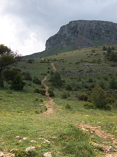
WThe Aizkorri-Aratz Natural Park is the second-largest natural park in the Basque Country, extending over 16,000 hectares, in the Aizkorri-Aratz Mountain Range. Included in the park are the highest summits in the Cantabrian-Mediterranean watershed, which together form a massif that is a centre for Basque mountaineering. Declared a natural park in 2006, the area contains limestone ridge-and-valley and siliceous intrusion biomes.
 W
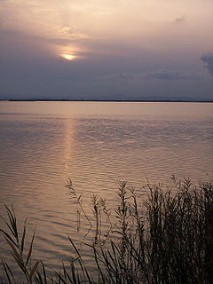
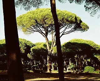
WThe Albufera, La Albufera or L'Albufera de València, is a freshwater lagoon and estuary on the Gulf of Valencia coast of the Valencian Community in eastern Spain. It is the main portion of the Parc Natural de l'Albufera de València, with a surface area of 21,120 hectares. The natural biodiversity of the nature reserve allows a great variety of flora and fauna to thrive and be observed year-round. Though once a saltwater lagoon, dilution due to irrigation and canals draining into the estuary and the sand bars increasing in size had converted it to freshwater by the seventeenth century.
 W
WMonte Aloia is a summit in the mountains of Galicia, Spain, which was declared a natural park on 4 December 1978. The park covers an area of 746 hectares and is located within the municipality of Tui, a town on the River Miño.
 W
WArribes del Duero Natural Park is a protected area in western Spain, covering 106.105 ha in the autonomous community of Castile and León. In this area the river Duero forms the national boundary between Spain and Portugal, and the Portuguese side is also protected under the International Douro Natural Park. The most notable characteristics of this natural space are its biodiversity and range of watercourses, which have eroded deep valleys and vertiginous precipices. This landscape is known as Arribes, which is where the reserve name comes from.
 W
WBahía de Cádiz Natural Park is a 10,522-hectare (26,000-acre) natural park located in the province of Cádiz. It was established in 1989.
 W
WBaixa Limia – Serra do Xurés is a 209 km2 (81 sq mi) natural park in Galicia, Spain. It is located in the southern province of Ourense. The park was established in 1993. Serra do Xurés is the Galician name for a range of mountains which straddle the border between Spain and Portugal: the Portuguese variant is Gerês.
 W
WThe Bardenas Reales is a semi-desert natural region, or badlands, of some 42,000 hectares in southeast Navarre (Spain). The soils are made up of clay, chalk and sandstone and have been eroded by water and wind creating surprising shapes, canyons, plateaus, tabular structures and isolated hills, called cabezos. Bardenas Reales lacks urban areas, vegetation is scarce and the many streams that cross the territory have a markedly seasonal flow, staying dry most of the year.
 W
WBenidorm Island is a small island and nature reserve of Spain, off the Spanish Mediterranean coast. The island is near the holiday town of Benidorm, sitting approximately 3.5 kilometres (2.2 mi) from the Spanish mainland. Tourists to the area can take boat trips from the mainland to the island to visit its wildlife, most notably its population of wild peacocks.
 W
WCabo de Gata-Níjar Natural Park in the southeastern corner of Spain is Andalusia's largest coastal protected area, a wild and isolated landscape with some of Europe's oldest geological features. Spain's southeast coast, where the park is situated, is the only region in mainland Europe with a true hot desert climate.
 W
WCañón del Río Lobos Natural Park is a natural park protected by the autonomous community of Castile and León, Spain. Two thirds of the park are located in the province of Soria and another third is in the province of Burgos. It is a limestone landscape. It includes a Special Protection Area.
 W
WThe Chinijo Archipelago is a small archipelago located in the northeastern part of the Canary Islands, north of the island of Lanzarote. The archipelago includes the islets of Montaña Clara, Alegranza, La Graciosa, Roque del Este and Roque del Oeste. The archipelago is administered by Lanzarote and belongs to the municipality of Teguise. La Graciosa is the only inhabited island, with a population of around 700.
 W
WThe Columbretes Islands (Valencian: Les Columbretes, IPA: [les kolumˈbɾetes] or Els Columbrets, are a group of small uninhabited islets of volcanic origin, in the Mediterranean Sea, 49 kilometres off Orpesa. Administratively they belong to Castelló de la Plana in the Valencian Country.
 W
WDespeñaperros is a gorge or canyon carved out by the Despeñaperros River. It is located in the municipality of Santa Elena in the northern portion of the province of Jaén, Spain. The 76.49-square-kilometre (29.53 sq mi) area was declared a natural park by the Andalusian Autonomous Government, primarily for its geology and landscape, but also for its notable flora and fauna.
 W
WSa Dragonera is an uninhabited islet in the Balearic Islands, Spain, located just off the west coast of Majorca. It is currently a natural park.
 W
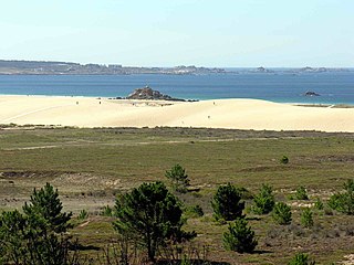
WDunes of Corrubedo Natural Park is a 4 square miles (10 km2) natural park on the Atlantic coast of Spain. It is one of six natural parks in the autonomous community of Galicia. It is situated at the very end of the Barbanza Peninsula in the province of A Coruña.
 W
WEl Estrecho Natural Park is a natural park in Spain, located on the northern side of the Strait of Gibraltar.
 W
WEl Surar is a Municipal Natural Park located in the east of Spain, within the comarca of Vall d'Albaida in the autonomous community of Valencia; it is shared between the municipalities of Pinet and Llutxent.
 W
WThe Font Roja Natural Park is a natural park situated in Alcoy, in the autonomous community of Valencia, Spain.
 W
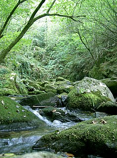
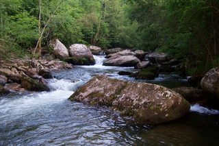
WThe Fragas do Eume is a natural park situated in north-west Spain. Fraga is a Galician word for "natural woodland", and the park is an example of a temperate rainforest in which oak is the climax vegetation. The protected area extends along the valley of the river Eume within the Ferrolterra municipalities of Pontedeume, Cabanas, A Capela, Monfero, Pontedeume, and As Pontes de García Rodríguez. Some 500 people reside within the park. The monastery of Saint John of Caaveiro also lies within the park.
 W
WMontaña Palentina is a natural park in the north of the province of Palencia in Castile and León, Spain.
 W
WFuentes del Narcea, Degaña e Ibias Natural Park is a natural park in the Principality of Asturias in northern Spain. It protects a natural landscape at the sources of the rivers Narcea and Ibias. It is located within the municipalities of Cangas del Narcea, Degaña and Ibias. The park was designated in 2002 and incorporated the preexisting Muniellos biosphere reserve, which was extended in 2003.
 W
WGorbea Natural Park is a protected area that is located between the provinces of Alava and Vizcaya in the Basque Country (Spain), the largest Basque natural park with an area of 20,008 hectares. It covers the municipalities of Areatza, Artea, Orozko, Zeberio, and Zeanuri in Vizcaya and Zigoitia, Zuia and Urkabustaiz in Álava. Gorbea Natural Park, along with the nearby natural park of Urkiola, form an important environmental unit. Natural Park was declared by the Basque Government Decree on 21 June 1994 with the purpose of protecting their natural heritage while promoting rural development, understanding and enjoyment. It takes its name from its highest peak, the Gorbea of 1,482 metres (4,862 ft). Other peaks of interest are Aldamin Peña of 1,373 metres (4,505 ft) and the Peñas de Itxina.
 W
WHoces del Rio Duratón Natural Park is a natural park of 5,037 hectares 1,2 km West from Sepúlveda, Segovia. Its name refers to the Duratón River. "Las Hoces" refers to the series of 100m high gorges that were formed by the Duratón.
 W
WIlla Grossa, is the largest island of the Columbretes archipelago of Spain, located in the Mediterranean Sea. It has a surface area of 14 hectares, or 0.05 square miles. It sits 60 km from Costa del Azahar. The island has experienced a rifting process since the lower Miocene, and is characterized by a significant presence of basalt materials. It is the result of a number of craters forming a chain, and its shape resembles the halve of an ellipse with an average diameter of 1 km, with two main elevations. The island's highest point, located in the northern section, is called mount Colibrí or Colibre. Along with the rest of the islands of the archipelago, it belongs to the Columbretes Islands Natural Reserve.
 W
WIzki Natural Park is located in the eastern quarter of the Province of Álava, in the Basque Country autonomous community, Spain. Its height is between 700 and 800 metres.
 W
WLa Breña y Marismas del Barbate Natural Park is a natural park on the coast of the province of Cádiz, Spain. The park includes marine and terrestrial ecosystems. An area of the natural park has been planted with pines to control the spread of sand-dunes.
 W
WLagunas de Ruidera Natural Park is a natural park in Spain, containing 15 small lagoons, the Lagunas de Ruidera, that are located in the La Mancha plain. The park's area is covers roughly 38 square kilometres (15 sq mi), reaching into the municipalities of Argamasilla de Alba, Ruidera, Alhambra, Ossa de Montiel and Villahermosa.
 W
WLos Alcornocales Natural Park is a natural park located in the south of Spain, in the autonomous community of Andalusia; it is shared between the provinces of Cádiz and Málaga. The natural park occupies a territory spanning seventeen municipalities with a total population of about 380,000. "Los Alcornocales" means "the cork oak groves".
 W
WThe Serra Mariola Natural Park is a mountain range in the Valencian Community, Spain, one of the most peripheral offsprings of the Baetic System. Most of its territory is included in a natural park founded in 2002, covering an area of 17,257 ha.
 W
WThe Cristina Island marshes are located at the mouth of the river Carreras in the province of Huelva, Andalusia, in southern Spain. Created in 1989, the natural park has a surface area of 21.45 square kilometres (8.28 sq mi), shared between the municipalities of Ayamonte and Isla Cristina.
 W
WMontes de Málaga Natural Park is the name of a natural park in Andalusia, Spain. It is named after the Montes de Málaga range located near Málaga city and was established in 1989.
 W
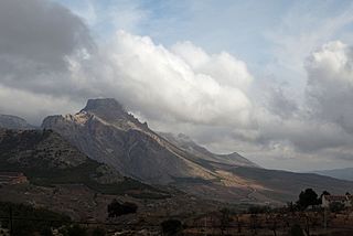
WMontgó is a mountain in Alicante Province, Spain, which rises to 753 metres (2,470 ft). It is the last spur on the Cordillera Prebética Mountain Range and is located in the Marina Alta region in the north of Alicante between the towns of Dénia and Xàbia. The mountain rises dramatically from the valley floors surrounding it and dominates the skyline for miles around. Its craggy cliffs are home to some of the most unusual flora and fauna in Spain. The mountain is renowned for its rock formations, cliffs, caves and natural harbours. From the Xàbia side Montgó is often said to resemble the head and trunk of an elephant. The mountain can be easily reached by highway CV-736 which links Denia with Jávea, both of which are accessible via the AP-7 motorway or the N-332 national highway.
 W
WPagoeta Natural Park is a park in Spain. Mount Pagoeta is closest to the villages of Aia and Laurgain, and near the coastal towns of Zarautz and Orio. The park features a park house, a museum, and picnic areas. Group guided tours are available.
WEs Pantaleu (Catalan) or El Pantaleu (Spanish) is an uninhabited islet in the Balearic Islands, Spain, located just off the west coast of Majorca. It is currently a natural park, part of the natural park of its neighboring island Dragonera. It has an area of 2,4 ha and its highest point is 26 m AMSL.
 W
WThe Peñalara Natural Park is a natural park of 7.68 km2 in the northwest of the Community of Madrid, Spain. It was designated in June 1990. The park is situated in the central zone of the Sierra de Guadarrama. Since 2013 the Sierra de Guadarrama has also been protected by a national park designation.
 W
WPenyal d'Ifac Natural Park is a natural park situated in Calp, in the Valencian Community, Spain.
 W
WPilancones Natural Park is located in San Bartolomé de Tirajana municipality on the island of Gran Canaria, Spain. Its area is 5794.4 ha. It adjoins Roque Nublo country park to the north, and Fataga protected area to the east. The park plays an important role in soil protection and the replenishment of an aquifer, along which there are several ravines running southward which are of geomorphological interest and landscape value. The pine forests on hilltops are a well-preserved habitat with abundant bird life. The park also harbours several varieties of cactus and spurge, and a number of aquatic habitats. The park takes its name from natural pools, formerly known locally as pilancones, which remain after the runoff of water. Throughout the area there are threatened animal and plant species, and features of scientific interest.
 W
WThe Natural Park of Posets-Maladeta is a Natural park located in northern Province of Huesca, Aragón, northeastern Spain. It is set within the Pyrenees.
 W
WThe Redes Natural Park is located in the Principality of Asturias in northern Spain. Its total area is 377.36 km2 (145.70 sq mi), split between two municipalities: Caso and Sobrescobio. It was declared a natural park in 1996.
 W
WSaja-Besaya Natural Park is Cantabrias largest natural park on the northern slope of the Cantabrian Mountains in West Central Cantabria, Spain.
 W
WThe Sanabria Lake Natural Park is a natural park in Spain located around Sanabria Lake in the Sanabria comarca, northwest part of the Zamora Province, in the mountainous area of Sierra Segundera and Sierra de la Cabrera. It occupies a surface area of 22,365 ha, with heights ranging from 997 m at the lake banks to the 2,124 m of the peak of Peña Trevinca. The park spans across the municipalities of Galende, Cobreros, Trefacio y Porto de Sanabria.
 W
WSerra d'Espadà is a 51 km (32 mi) long mountain range in the Alt Palància, Alt Millars and Plana Baixa comarcas, in the Province of Castellón, Valencian Community, Spain. Its highest point is La Ràpita.
 W
WSerra d'Irta Natural Park is a natural park with 7,744 hectares of land, as well as a marine nature reserve. These mountain and shoreline areas were declared a protected area by the Valencian government on July 16, 2002.
 W
WSierra de Aracena and Picos de Aroche Natural Park is a protected area in the Sierra de Aracena range, part of the Sierra Morena mountain system, Huelva Province, southwestern Spain.
 W
WThe Sierra de Francia is a mountain range located in Sierra de Francia Comarca at the southern end of Salamanca Province, Castile and León, Spain. It is located about 70 km from Salamanca city. The region is sparsely inhabited and its few towns have great cultural value.
 W
WThe Sierra de Francia is a comarca located at the southern end of Salamanca Province, Castile and León, Spain. It is located about 70 km from Salamanca city. It borders with the Las Hurdes and Las Batuecas comarcas of Extremadura to the south; the Campo Charro to the north and the Sierra de Béjar to the east. The region is sparsely inhabited and its few towns have great cultural value.
 W
WThe Sierra de Grazalema Natural Park is a natural park in the northeastern part of the province of Cádiz in southern Spain. The park encompasses, within its 51,695 hectares, a complex of mountain ranges, known collectively as the Sierra de Grazalema, which, in turn, are part of the Cordillera Subbética. Other ranges within the park, comprising the Sierra de Grazalema, include the Sierra de Zafalgar, the Sierra del Pinar, and the Sierra de Endrinal. Pinar, 1654 metres in elevation, is the tallest peak.
 W
WThe Sierra de Huétor and la Alfaguara Natural Park is a natural park in Andalusia, Spain. It is located near Granada city and was established in 1989.
 W
WThe Sierra de las Nieves Natural Park is a natural park in the Sierra de las Nieves range, Andalusia, southern Spain. It is located behind Marbella and to the east of the road to Ronda from the Costa del Sol. It is a candidate to become a Spanish national park.
 W
WSierra de María-Los Vélez Natural Park is a natural park of Spain. It is situated in Almería province in the municipalities of Chirivel, Maria, Vélez-Blanco, Vélez-Rubio.
 W
WThe Sierra y Cañones de Guara Natural Park is a Spanish Natural park in the Sierra de Guara mountain range, located in the Province of Huesca, Aragon, northern Spain. It was established in 1990.
 W
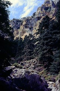
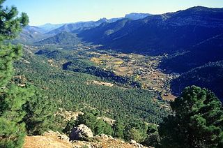
WSierras de Cazorla, Segura y Las Villas Natural Park is a natural park in the eastern and northeastern part of the province of Jaén, Spain, established in 1986. With an area of 2,099.2 square kilometres (810.5 sq mi), it is the largest protected area in Spain and the second largest in Europe. It was declared a biosphere reserve by UNESCO in 1983 and also a Special Protection Area for migratory birds in 1988.
 W
WSomiedo Natural Park is a natural park located in the central area of the Cantabrian Mountains in the Principality of Asturias in northern Spain.
 W
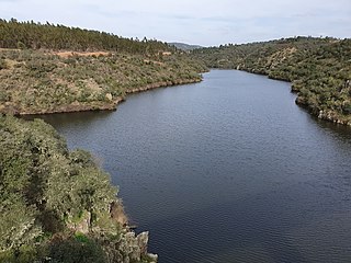
WThe International Tagus Natural Park is a protected area in Portugal and Spain.
 W
WUrkiola Natural Park is a protected area located in the southeastern corner of Biscay and Álava in the northern Basque Country, Spain. It is a protected area of 5,958 hectares.