 W
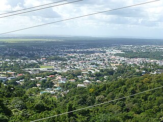
WArima, officially The Royal Chartered Borough of Arima is the easternmost and second largest in area of the three boroughs of Trinidad and Tobago. It is geographically adjacent to Sangre Grande and Arouca at the south central foothills of the Northern Range. To the south is the Caroni–Arena Dam. Coterminous with Town of Arima since 1888, the borough of Arima is the fourth-largest municipality in population in the country. The census estimated it had 33,606 residents in 2011.
 W
WArouca is a town in the East–West Corridor of Trinidad and Tobago located 19 km (12 mi) east of Port of Spain, along the Eastern Main Road. It is located west of Arima, east of Tunapuna and Tacarigua, south of Lopinot, and north of Piarco. It is governed by the Tunapuna–Piarco Regional Corporation. Arouca may be a corruption of Arauca, an Amerindian tribe.
 W
WBarataria is a town in Trinidad and Tobago. It is east of Port of Spain and Laventille and west of San Juan. It is part of the East–West Corridor.
WBarrackpore is a town in southern Trinidad and Tobago. It is located southeast of San Fernando, east of Debe, and northeast of Penal, and is under the administrative authority of the Penal–Debe Regional Corporation.
WBiche is a village in east Trinidad and Tobago 18 kilometers south of Sangre Grande and 18 kilometers north of Rio Claro.
 W
WBlanchisseuse is a village in Trinidad and Tobago. It is located about midway along the north coast of Trinidad on the northern slope of the Northern Range, about 24 km north of Arima.
WBonasse is a town on the Cedros peninsula in Siparia, Trinidad and Tobago. The origin of its name is French.
 W
WCarapichaima is a town in central Trinidad, Trinidad and Tobago. Communities and villages in Carapichaima include Orangefield, Waterloo, Brickfield, and Korea Village.
 W
WCarenage is a town in the Republic of Trinidad and Tobago. It is located in northwestern Trinidad, and is administered by the Diego Martin Regional Corporation. Located close to Chaguaramas, it is more of a residential area than a commercial or industrial locale.
WCedar Hill Village is a rural community in Trinidad and Tobago which covers an area of approximately four square kilometres. It is about two kilometres from Princes Town. It can be found along the Manahambre Road.
 W
WThe coastal area known as Cedros lies on a peninsula at the South-Western end of the island of Trinidad. Located at the tip of the peninsula, Cedros or Bonasse as it is more commonly known especially on maps, lies mere miles off the coast of Venezuela, and is the most southern point in the Caribbean. According to a Trinidad Guardian article, "Cedros is the closest legal point of entry to Venezuelans wishing to enter Trinidad and Tobago."
 W
WThe Borough of Chaguanas is the largest borough and fastest-growing town in Trinidad and Tobago. Located in west-central Trinidad, south of Port of Spain, north of Couva and San Fernando, named after the indigenous tribe who originally settled there, it grew in size due to its proximity to the Woodford Lodge sugar refinery. It remained a minor town until the 1980s when it began to grow rapidly as it drew people for its bargain shopping and moderately priced housing. Its rapid growth has seen property values increase dramatically, however.
 W
WChaguaramas lies in the North West Peninsula of Trinidad west of Port of Spain; the name is often applied to the entire peninsula, but is sometimes used to refer to its most developed area. The developed area in Chaguaramas starts at ALCOA and ends at the Army and Coast Guard camps on the mainland. In the description or context of "developed area" one excludes the five islands which are in various stages of development or redevelopment as of 2016. However in the information below, some data is included on the Five Islands
WClaxton Bay is a community in the Republic of Trinidad and Tobago. It is located in west-central Trinidad, and is administered by the Couva–Tabaquite–Talparo Regional Corporation. Olympic cyclist Hylton Mitchell was born here.
 W
WCouva is an urban town in west-central Trinidad, south of Port of Spain and Chaguanas and north of San Fernando and Point Fortin. It is the main urban and commercial centre of Couva–Tabaquite–Talparo, and the Greater Couva area includes the Point Lisas Industrial Estate and the Port of Point Lisas. It is one of the fastest growing towns in the country. Couva's southern boundary is at the village of California & Point Lisas, and to the north Couva stretches to McBean. To the east of Couva is Preysal. To the west of Couva is the road to Waterloo and Carli Bay, which are located on the Gulf of Paria. Couva was part of the Caroni County. Couva is considered a major power base for the United National Congress (UNC), whose headquarters are located here.
WCunupia is a town in central Trinidad. It is part of the Borough of Chaguanas. Cunupia is just northeast of Chaguanas proper. Like Chaguanas itself, Cunupia has experienced rapid growth in recent years, especially in terms of residential developments.
 W
WCurepe is a town in the East–West Corridor of Trinidad and Tobago. It is located west of St Augustine and east of St Joseph. Curepe adjacents the St. Augustine campus of the University of the West Indies. Many of the students attending the university live in Curepe.
 W
WDebe is a town in south Trinidad located in the region of Penal–Debe. Debe has grown from a small settlement into a key transit point which as has merged to some extent with Penal. A denomination high school was established by the Sanatan Dharma Maha Sabha. Debe had initially gained importance as a train stop during sugar cane production. However with the closure of the sugar industry Debe continued to be widely known for doubles and other delicacies. The area has also gained prominence for its wholesale marketing of agricultural produce in government managed Namdevco, which is the largest wholesale market in the country. Chutney music is believed to have originated in the Barrackpore-Debe-Penal area.
 W
WDibe is a village in north Trinidad located northwest of downtown Port of Spain, Trinidad and Tobago. The village is home to the poor and the rich, who respectively live on the surrounding hills and meadows, which has been described as living between a rock and a hard place. Upper Dibe, better known as “Cripple Creek” or ‘’’the Creek”’, has had a dark history with incessant gang warfare for over three decades.
 W
WDiego Martin is a town and is the urban commercial center and capital of the Diego Martin region in Trinidad and Tobago. Its location in the region is just on the south eastern border, west of the capital city of Port of Spain and east of the town of Carenage. Diego Martin town in the Northern Range was once filled with a number of small valleys but is now a densely populated area. It was named after a Spanish explorer Don Diego Martín. The area was settled by French planters and their slaves in the 1780s. It consists of a cluster of communities including Congo Village, Diamond Vale, Green Hill, Patna Village, Petit Valley, Blue Range, La Puerta Avenue, Four Roads, Rich Plain, River Estate, Blue Basin, Water Wheel, West Moorings, Bagatelle and Sierra Leone.
 W
WDow Village is a village west of South Oropouche in Trinidad and Tobago. It is located in the region of Siparia. It is often confused with another Dow Village located near the neighbourhood of California, just east of Southern Main Road, in Couva.
WFyzabad is a town in southwestern Trinidad, 13 km (8.1 mi) south of San Fernando, west of Siparia and northeast of Point Fortin. It is named after the town of Faizabad in India. Colloquially it is known as "Fyzo" by many people.
 W
WGrande Riviere is a village on the north coast of Trinidad located between Toco and Matelot. The area was originally settled by immigrants from Venezuela and Tobago who cultivated cacao and subsistence crops. After falling cocoa prices in the 1920s and expanding pest problems caused the collapse of the cocoa industry, Grande Riviere went into a decline which continued until the development of ecotourism. Between 1931 and 2000 the population of Grande Riviere fell from 718 to 334.
 W
WGuayaguayare is the southeasternmost village in Trinidad and Tobago. It lies at the southern end of the county of Mayaro. Guayaguayare is primarily a fishing village, but it also plays a major role in the petroleum industry. The largest petroleum producers in the country - BP Trinidad & Tobago (bpTT), BHP Billiton and Petrotrin all have major presences here and bpTT controls the Port of Guayaguayare, which services most of the offshore petroleum production in Trinidad. The major natural gas pipelines, serving Atlantic LNG in Point Fortin and the Point Lisas Industrial Estate, come ashore here.
WThe village of Moruga lies on the central south coast of Trinidad at the western end of the Trinity Hills. It is in Victoria County, Trinidad and Tobago, and is served by the Princes Town Regional Corporation.
 W
WIere Village is a small village in southern Trinidad, north west of Princes Town. Though small in size, the village is rich in history. It is the site of the first Presbyterian church, the first Islamic mosque and the first government funded school in Trinidad. The village is located on the Naparima Mayaro Road just outside Princes Town. The village's primary school, Iere Government Primary, has been rebuilt and located further up the road from its original location on Richmond.
 W
WKelly Village is a village in the Tunapuna–Piarco region of Trinidad and Tobago. The village is bordered by the Caroni River to the north, La Paille to the northwest, Frederick Settlement to the west, Warren to the southwest, Piarco to the north and east, St. Helena to the southeast, and Cunupia to the south. Kelly Village is located right next to the Piarco International Airport. The Caroni South Bank Road runs through the center of the village. The village is governed by the Kelly Village Council. Their member of parliament is Dr. Tim Gopeesingh. The village has an online channel named Kelly Village TV (KVTV) that broadcasts the news and affairs of the village. The village has a Hindu temple: the Kelly Village Shiv Mandir. Kelly Village also has the Islamic Center Mosque. The village also has the Bethel's Spiritual Baptist Church, Hydraulic Road Kelly Village Community Bible Church, the Kelly Presbyterian Church, the Kelly Community Bible Church, and the Jesus Life Center Pentecostal Church.
 W
WLa Brea is a town in southwestern Trinidad, located northeast of Point Fortin and southwest of San Fernando. La Brea . is best known as the site of the Pitch Lake, a natural asphalt lake. Pronunciation of "La Brea" differs from that used in the USA at the La Brea Tar Pits in Los Angeles. Trinidadians call this place "La Bray."
 W
WLaventille is a ward of Trinidad and Tobago.
 W
WMacoya is a small town located alongside the Churchill-Roosevelt Highway in Trinidad and Tobago. It is located between Tunapuna and Trincity on the island of Trinidad. It is composed primarily of commercial warehouses and a small residential neighbourhood.
 W
WMarabella is a former town in southern Trinidad, between San Fernando and Pointe-à-Pierre. Early 19th century maps highlighted it as Marabella Junction because of the Railway intersection to Williamsville and other central areas. Originally a separate town, it was incorporated into the City of San Fernando in the 1990s.
 W
WMaraval is one of the northern suburbs of Trinidad's capital, Port of Spain, a valley in northern Trinidad in Trinidad and Tobago. It is situated at the bottom of the hills of Paramin and located east of the Diego Martin valley to which it is connected directly by Morne Coco Road, and west of Santa Cruz valley, to which it is connected by Saddle Road.
 W
WMatelot is a settlement in Trinidad and Tobago. Located on the north coast of Trinidad in the Sangre Grande region, the village has traditionally been seen as one of the most remote places on the island.
 W
WMayaro is a town in Mayaro County on the island of Trinidad in Trinidad and Tobago.
 W
WMorvant is a community in Trinidad and Tobago located east of Port of Spain and west of Barataria.
 W
WParamin is a village located on one of the highest points of western area of the Northern Range in Trinidad, Trinidad and Tobago, which forms part of the Maraval area. It is a sprawling, steep and mountainous village whose residents have traditionally been farmers, producing herbs like chives, thyme and parsley, as well as vegetables like tomatoes and yams.
WPenal is a town in south Trinidad, Trinidad and Tobago. It lies south of San Fernando, Princes Town, and Debe, and north of Moruga and Siparia. It was originally a rice- and cocoa-producing area but is now a rapidly expanding and developing town. The population is 12,281.
WPiarco is a town in northern Trinidad and is the site of Piarco International Airport.
 W
WPiparo is a village in Central Trinidad on the southern edge of the Central Range. The village has three main claims to fame:Piparo was the base of operations of Dole Chadee, a notorious drug lord who was executed in 1999 for the murder of four members of the Baboolal family. Piparo was the home of Ras Shorty I during his self-imposed break from the soca world. Living simply in this rural community Ras Shorty-I developed Jamoo, a fusion of soca and gospel music. Piparo was the site of a large mud volcano eruption on February 22, 1997. The eruption covered an area of 2.5 km² and displaced 31 families. The mud volcano now lies active where the eruption took place.
 W
WPoint Fortin, officially the Republic Borough of Point Fortin, the smallest Borough in Trinidad and Tobago is located in southwestern Trinidad, about 32 km (20 mi) southwest of San Fernando, in the historic county of Saint Patrick. After the discovery of petroleum in the area in 1906 the town grew into a major oil-producing centre. The town grew with the oil industry between the 1940s and 1980s, culminating in its elevation to borough status in 1980. After the end of the oil boom Point Fortin was hit hard by economic recession in the 1980s and the closure of its oil refinery. Construction of a Liquefied Natural Gas plant by Atlantic LNG in late 1990s boosted the economy.
 W
WPoint Lisas is a major industrial centre in Trinidad and Tobago and is host to the Point Lisas Industrial Estate and the Port of Point Lisas, both of which are managed by Plipdeco. Point Lisas is located in Couva, Trinidad and Tobago and on the Gulf of Paria coastline.
 W
WPointe-à-Pierre is a town in Trinidad and Tobago. It lies north of San Fernando and south of Claxton Bay. It is most famous as the site of the country's largest oil refinery which is run by Petrotrin, the state-owned oil company.
 W
WRio Claro is the largest town in southeastern Trinidad, in Trinidad and Tobago. Rio Claro lies east of Princes Town, west of Mayaro and northwest of Guayaguayare. It serves as the major commercial centre for southeastern Trinidad. It lies in a primarily agricultural area. It is the seat of the Rio Claro–Mayaro Regional Corporation.
 W
WSt. Augustine is a town in the northwest of Trinidad, Trinidad and Tobago.
 W
WSt. Joseph was founded in 1592 by Antonio de Berrio and is the oldest town in Trinidad and Tobago. Originally named San José de Oruña, it served as the capital of Spanish Trinidad between 1592 and 1783. In 1595 the place was attacked and held by Sir Walter Raleigh and was used as a base for his exploration of the Orinoco river in search of the fabled city of El Dorado. Soon after his return the place was burnt and sacked.
 W
WSan Juan is a town in Trinidad and Tobago. Located in San Juan–Laventille region in Saint George County, it lies within the East-West Corridor Metropolitan Area, between Barataria and Saint Joseph.
 W
WSangre Grande is the largest town in northeastern Trinidad and Tobago. It is located east of Arima and southwest of the village of Toco. It is the seat of the Sangre Grande Regional Corporation and capital of the region.
WSanta Cruz is a town in Trinidad and Tobago. It extends across the Santa Cruz Valley, between Maraval and San Juan, along the Saddle Road. It lies between the hills of the Northern Range, a mountain range.
WSiparia is a town in southern Trinidad, in Trinidad and Tobago, south of San Fernando, southwest of Penal and Debe and southeast of Fyzabad. Also called "The Sand City", it was originally a non-Mission Amerindian settlement. Siparia grew to be the administrative centre for Saint Patrick County, and later the Siparia Regional Corporation. Today it is a commercial centre and market town serving the surrounding agricultural areas and oil fields. Siparia is also the seat of the Siparia Regional Corporation.
 W
WSouth Oropouche is a community in Trinidad and Tobago. It is at sea level. There is an archaeological site at St John's Road, South Oropouche. Dow Village is in South Oropouche.
 W
WTacarigua is a town in the East–West Corridor of Trinidad and Tobago, located east of Tunapuna, north of Trincity and west of Arouca. It is on the banks of the Tacarigua River. The city is governed by the Tunapuna–Piarco Regional Corporation.
 W
WTalparo is a rural community in the Republic of Trinidad and Tobago. It is located in west-central Trinidad, and is administered by the Couva–Tabaquite–Talparo Regional Corporation.
WTrincity is a planned community in northern Trinidad. It is located along the East–West Corridor south of Tunapuna and north of Piarco.
 W
WTunapuna is a town in the East–West Corridor of the island of Trinidad, in Trinidad and Tobago.
WWestmoorings is a residential area in the region of Diego Martin on the island Trinidad, west of Port of Spain, the capital of Trinidad and Tobago. This suburb consists of mainly lower middle class to upper-class families and is generally known throughout the country for its upscale housing and expatriate population. This area mainly consists of small apartments and large upscale houses. It also has a few offshore moorings, a mall, a government college, the International School of Port of Spain, and a private primary school, Dunross Preparatory School. It is bordering the sea and Diego Martin river.