 W
WThe regions of the Netherlands provides links to both regions and subregions of the Netherlands.
 W
WIn the European Netherlands, safety regions are public bodies whose task is to facilitate regional cooperation in dealing with crises, disasters and disruptions of public order.
 W
WThe Achterhoek is a cultural region in the eastern Netherlands. Its name is geographically appropriate because the area lies in the easternmost part of Gelderland, and therefore in the east of the Netherlands, protruding into Germany. The Achterhoek lies at the East of the IJssel and Oude IJssel rivers. On the other sides, it the borders Germany and the Dutch province of Overijssel.
 W
WThe Alblasserwaard is a polder in the province of South Holland, Netherlands. It is mainly known for the windmills of Kinderdijk, located near the village of Kinderdijk in the polder's northwestern part.
 W
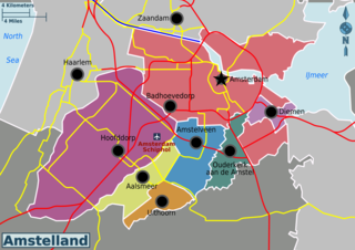
WAmstelland is the area along the river Amstel in the Netherlands, beginning in South Holland and running north towards Amsterdam in southern North Holland.
 W
WThe Amsterdam metropolitan area is the city region around the city of Amsterdam, the capital of the Netherlands. It lies in the Noordvleugel of the larger polycentric Randstad metropolitan area and encompasses the city of Amsterdam, the provinces of North Holland and Flevoland, as well as 36 further municipalities within the two provinces, with a total population of over 2.4 million inhabitants.
 W
WThe Arnhem–Nijmegen metropolitan area is a former Dutch plusregio, public body and intermunicipal institution, founded in 1988, for the co-operation in the areas of housing, transport and economics in the conurbation consisting of the Dutch cities of Nijmegen and Arnhem as well as the bordering municipalities of Berg en Dal, Beuningen, Doesburg, Duiven, Heumen, Lingewaard, Montferland, Mook en Middelaar, Overbetuwe, Renkum, Rheden, Rijnwaarden, Rozendaal, Westervoort, Wijchen, and Zevenaar. All except Mook en Middelaar (Limburg) are in the province of Gelderland. Its aim is regional cooperation. In 2011, a total of 736,107 people were living in the municipalities(1,000 km2).
 W
WBatavia is a historical and geographical region in the Netherlands, forming large fertile islands in the river delta formed by the waters of the Rhine and Meuse rivers. During the Roman empire, it was an important frontier region and source of imperial soldiers. Its name is possibly pre-Roman.
 W
WThe Biesbosch National Park is one of the largest national parks of the Netherlands and one of the last extensive areas of freshwater tidal wetlands in Northwestern Europe. The Biesbosch consists of a large network of rivers and smaller and larger creeks with islands. The vegetation is mostly willow forests, although wet grasslands and fields of reed are common as well. The Biesbosch is an important wetland area for waterfowl and has a rich flora and fauna. It is especially important for migrating geese.
 W
WBommelerwaard is a district in Gelderland, Netherlands.
 W
WBrabantse Stedenrij is a term used in Dutch urban planning to designate the polycentric city region in the province of North Brabant, Netherlands. It might loosely be translated into English as "Brabantine City Row". Its population is about 2 million. The main cities are 's-Hertogenbosch, Breda, Eindhoven, Helmond and Tilburg. Other municipalities of the area are Bergen op Zoom, Oss and Roosendaal. The metropolitan region also includes other large towns such as Boxtel, Etten-Leur, Oosterhout, Uden, Veghel, Veldhoven and Waalwijk.
 W
WThe Campine (French) or De Kempen (Dutch) is a natural region situated chiefly in north-eastern Belgium and parts of the south-eastern Netherlands which once consisted mainly of extensive moors, tracts of sandy heath, and wetlands. It encompasses a large northern and eastern portion of Antwerp province and adjacent parts of Limburg in Belgium, as well as portions of the Dutch province of North Brabant and Dutch Limburg around Weert.
 W
WThe City Region of Amsterdam is a group of 15 municipalities in the province of North Holland, comprising and located around Amsterdam. It was called ROA until 31 October
 W
WThe Drechtsteden are a number of towns and cities bordering each other in the delta area of the rivers Oude Maas, Noord, and Beneden-Merwede in the province of South Holland, Netherlands. These cooperate in the Gemeenschappelijke Regeling Drechtsteden, which performs common tasks for the municipalities in the field of economy, development, culture, and social assistance. Collectively, a little more than 250,000 people call one of the towns and cities of Drechtsteden home.
 W
WThe Duin- en Bollenstreek is a region in the western Netherlands, that features coastal dunes and the cultivation of flower bulbs. Situated at the heart of historical Holland nearby the city Leiden, South Holland, and boundered by The Hague and Haarlem, the combination of beaches, flower fields, lakes and history makes this area attractive to tourists.
 W
WThe Dutch Caribbean are the territories, colonies, and countries, former and current, of the Dutch Empire and the Kingdom of the Netherlands in the Caribbean Sea. They are in the north and south-west of the long Lesser Antilles archipelago.
 W
WThe Flevopolder is an island polder forming the bulk of Flevoland, a province of the Netherlands. Created by land reclamation, its northeastern part was drained in 1955 and the remainder—the southwest—in 1968.
 W
WGoeree-Overflakkee is the southernmost delta island of the province of South Holland, Netherlands. It is separated from Voorne-Putten and Hoeksche Waard by the Haringvliet, from the mainland of North Brabant by the Volkerak, and from Schouwen-Duiveland by Lake Grevelingen.
 W
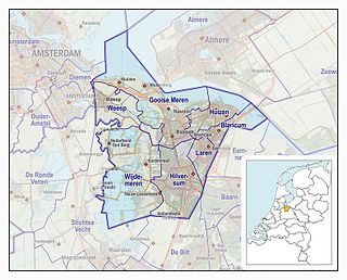
WThe Gooi is an area around Hilversum, in the centre of the Netherlands. It is a slightly hilly area characterised by its green landscape, its historical charm, the wealth of its inhabitants, and its villas. Het Gooi is known in the Netherlands as the home of the rich and famous.
 W
WHaaglanden is the conurbation surrounding The Hague in the Netherlands. The city's position as the country's seat of government makes the region prominent in the Netherlands. Located on the west coast of the province of South Holland, the region has a population of 1,050,543 as of September 2013, and covers an area of 405 km².
 W
WThe Hoekse Waard is an island between the Oude Maas, Dordtsche Kil, Hollands Diep, Haringvliet and Spui rivers in the province of South Holland in the Netherlands. The island, part of the namesake municipality of Hoeksche Waard, is a mostly agricultural region, south of the outskirts of Rotterdam. The Hoeksche Waard consists of reclaimed land (polders): after the Saint Elisabeth flood of 1421 most of the area was flooded. The land has been reclaimed gradually in the following centuries.
 W
WHolland is a region and former province on the western coast of the Netherlands. The name Holland is also frequently used informally to refer to the whole of the country of the Netherlands. This usage is commonly accepted in other countries and is also commonly employed by the Dutch themselves However, some in the Netherlands, particularly those from regions outside Holland, may find it undesirable, even offensive or misrepresentative to use the term for the whole country.
 W
WThe Hondsrug is a Dutch ridge of sand that is mainly located in the province Drenthe and partly in the province Groningen.
WIJsselmonde is a river island in the Netherlands, between the Nieuwe Maas, Noord and Oude Maas branches rivers of the Rhine-Meuse delta in the province of South Holland. The city of Rotterdam now occupies most of the northern part of the island and includes the eponymous former village of IJsselmonde, once a separate community. The island was once a rich agricultural region, but is mostly suburbs today. Only the mid-south parts of the island have retained their agricultural character.
 W
WKennemerland is a coastal region in the northwestern Netherlands, in the province of North Holland. In includes the sand dunes north of the North Sea Canal, as well as the dunes of Zuid-Kennemerland National Park.
 W
WThe Kop van Overijssel is a region in the very northwestern part of the Dutch province of Overijssel. It consists of the municipality of Steenwijkerland and matches the historical region of the Land van Vollenhove. In past times it comprised a wider area, the municipalities of Kampen, Zwartewaterland and Staphorst also belonging to it.
WThe Land of Altena is a historical region and former fiefdom of the Lords of Altena, historically part of the County of Holland, but since 1815 located in the Dutch province of North Brabant.
WThe Land of Heusden and Altena is a region located in the Dutch province of North-Brabant. In 1904 it consisted of the historical regions Land of Altena and Land of Heusden.
 W
WThe Meierij van 's-Hertogenbosch was one of the four parts of the duchy of Brabant, the others being the margraviate of Antwerp, the county of Brussels, and the county of Leuven/Louvain. It got its name from the Bailiff of 's-Hertogenbosch, which administered the area in the name of the Dukes of Brabant. The Meierij roughly corresponds to the somewhat larger Dutch province of North Brabant.
 W
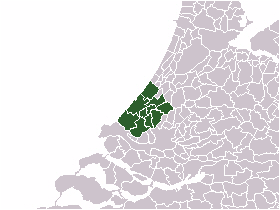
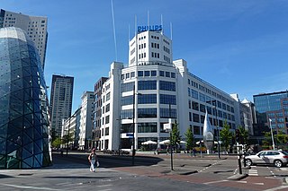
WThe Metropoolregio Eindhoven, until 1 January 2014 the Samenwerkingsverband Regio Eindhoven is a regional governmental agency for the city region of Eindhoven, Netherlands. The MRE comprises 21 municipalities in the Eindhoven agglomeration, with a total area of 1,457.81 square kilometers. The region has nearly three quarters of a million inhabitants and some 35.000 companies.
 W
WNoord-Beveland is a municipality and region in the southwestern Netherlands and a former island, now part of the Walcheren-Zuid-Beveland-Noord-Beveland peninsula. Noord-Beveland is enclosed by the Oosterschelde estuary to the north, and the former straits, now combined lake, of Veerse Meer and Zandkreek to the south. As part of the Delta Works, dams have connected Noord-Beveland to Walcheren and Zuid-Beveland.
 W
WNoorderkwartier is a historical term referring to the part of the former Dutch province of Holland north of the river IJ, covering the regions Kennemerland, Zaanstreek, Waterland and West Friesland and now part of the modern province of North Holland. Other historical terms for this area were "North Holland", "Noordeland", and "Noorderland".
 W
WNoordoostpolder is a polder and municipality in the Flevoland province in the central Netherlands. Formerly, it was also called Urker Land. Emmeloord is the administrative center, located in the heart of the Noordoostpolder.
 W
WThe Ommelanden are the parts of Groningen province that surround Groningen city. Usually mentioned as synonym for the province in the expression Stad en Ommeland.
 W
WDe Peel is a region in the southeast of the Netherlands that straddles the border between the provinces of North Brabant and Limburg.
 W
WThe Randstad is a megalopolis in the central-western Netherlands consisting primarily of the four largest Dutch cities and their surrounding areas. Among other things, it contains the Port of Rotterdam, the Port of Amsterdam, and Amsterdam Airport Schiphol. With a population of 8.2 million people it is one of the largest metropolitan regions in Europe, comparable in population size to the Milan metropolitan area or the San Francisco Bay Area, and covers an area of approximately 8,287 km2 (3,200 sq mi). With a population density of 1,500/km2 (3,900/sq mi) it also is one of the most important and densely populated economic areas in northwestern Europe. It encompasses both the Amsterdam metropolitan area and Rotterdam–The Hague metropolitan area.
 W
WThe Rheiderland is a region of Germany and the Netherlands between the River Ems and the Bay of Dollart. The German part of the Rheiderland lies in East Frisia, west of the Ems. The Dutch part lies in the Dutch province of Groningen and is mostly part of Oldambt. The Rheiderland is one of the four historic regions on the mainland in the district of Leer; the others being the Overledingerland, the Moormerland and the Lengenerland.
 W
WThe name Rijnland means "Rhineland" in Dutch. When referring to the Rhine in Germany, "Rijnland" has the same meaning as "Rhineland" in English or "Rheinland" in German. However, "Rijnland" has a specific, different meaning in a Dutch context - the area along the Oude Rijn.
 W
WRijnmond is the conurbation surrounding the city of Rotterdam in the Netherlands. Another term used in this context is Stadsregio Rotterdam. Located on the Rhine–Meuse–Scheldt delta, the region has a combined population of 1,242,378 as of 2016.
 W
WSalland is a historical dominion in the west and north of the present Dutch province of Overijssel. Nowadays Salland is usually used to indicate a region corresponding to the part of the former dominion more or less to the west of Twente.
 W
WSchouwen-Duiveland is a municipality and an island in the southwestern Netherlands province of Zeeland. The municipality has 33 737 inhabitants and covers an area of 488.94 square kilometres.
 W
WTwente is a region in the eastern Netherlands. It encompasses the most urbanised and easternmost part of the province of Overijssel. Twente is most likely named after the Tuihanti or Tvihanti, a Germanic tribe that settled in the area and was mentioned by the Roman historian Tacitus. The region's borders are defined by the Overijssel region of Salland in the northwest and west, the German County of Bentheim in the northeast and east and the Gelderland region of the Achterhoek in the south.
 W
WUden-Veghel is a polycentric metropolitan area, centred on the towns of Uden and Veghel, in the east of the province of North Brabant in the southern Netherlands. It consists of the neighbouring municipalities of Uden and Veghel with the surrounding municipalities of Schijndel, Sint-Oedenrode, Bernheze, Landerd and Boekel.
 W
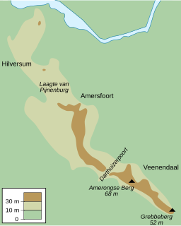
WUtrecht Hill Ridge is a ridge of low sandhills that stretches in a direction from southeast to northwest over the Dutch province of Utrecht and over a part of North Holland. The total length of the region is about 50 km. It covers an area of approximately 23,000 hectares. The part of the ridge in North Holland is commonly called “Het Gooi”.
 W
WThe Vechtstreek is a region in the Dutch provinces of Utrecht and North Holland along the Vecht River between the towns of Utrecht and Amsterdam. Located in the economic heartland of the Netherlands, it is known for its natural environment, castles, parks and stately homes.
 W
WThe Veluwe is a forest-rich ridge of hills (1100 km2) in the province of Gelderland in the Netherlands. The Veluwe features many different landscapes, including woodland, heath, some small lakes and Europe's largest sand drifts.
 W
WVijfheerenlanden, literally "lands of five Lords", is a municipality in the province of Utrecht in the Netherlands. The municipality was created on 1 January 2019 through the merger of the former municipalities of Vianen (Utrecht), Leerdam and Zederik.
WVoorne-Putten is an island between the North Sea, the Brielse meer and the rivers Oude Maas, Spui and Haringvliet in the province of South Holland in the Netherlands. Voorne-Putten consists of the two former islands Voorne and Putten. It used to be separated by the river Bernisse which silted up and made the two islands one. It has 160,000 inhabitants (2008). Recently the riverbed has been dredged, and the two islands have been reformed.
 W
WWalcheren is a region and former island in the Dutch province of Zeeland at the mouth of the Scheldt estuary. It lies between the Eastern Scheldt in the north and the Western Scheldt in the south and is roughly the shape of a rhombus. The two sides facing the North Sea consist of dunes and the rest of its coastline is made up of dykes. Middelburg, the provincial capital, lies at Walcheren's center. Vlissingen, 9 kilometres (5.6 mi) to the south, is the main harbour and the third municipality is Veere.
 W
WWest Friesland a contemporary region in the Northwest of the Netherlands, in the province of North Holland.
 W
WWestland is a region of the Netherlands and lies in the western part of the Province of South Holland. It consists of the municipalities of Westland and Midden-Delfland, and also of the town of Hook of Holland.
 W
WZeelandic Flanders is the southernmost region of the province of Zeeland in the south-western Netherlands. It lies south of the Western Scheldt that separates the region from the remainder of Zeeland and the Netherlands to the north. Zeelandic Flanders is bordered to the south by Belgium.
 W
WZuid-Beveland is part of the province of Zeeland in the Netherlands north of the Western Scheldt and south of the Eastern Scheldt.
 W
WZuidvleugel is the band of cities and towns located along the southern wing of the Randstad in the Netherlands. It is that part of the Randstad that is located in the Province of South Holland. This developing conurbation extends around 60 kilometres from Dordrecht to Leiden. The two main focal points are the area around Rotterdam and the area around The Hague.
WIJsselmonde is a river island in the Netherlands, between the Nieuwe Maas, Noord and Oude Maas branches rivers of the Rhine-Meuse delta in the province of South Holland. The city of Rotterdam now occupies most of the northern part of the island and includes the eponymous former village of IJsselmonde, once a separate community. The island was once a rich agricultural region, but is mostly suburbs today. Only the mid-south parts of the island have retained their agricultural character.