 W
WArnos Vale is a former agricultural estate and now a settlement in Greathead Bay, formerly Warrawarrou Bay, in southern Saint Vincent, in Saint Vincent and the Grenadines. It is centred 5 kilometres southeast of the capital, Kingstown. The country's former main airport, E. T. Joshua Airport occupied part of the area, and used to be called Arnos Vale Airport. The area is mainly green and has a coastline to the south. As to the traditional parishes of the island, determining the local forerunner church and present local body, it lies in the parish of Saint George, which contains the capital and about half of the island's population. It is one of five parishes on the main island.
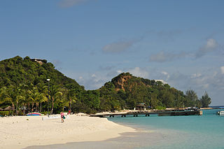
WAshton is a town located on Union Island, which is part of the Grenadines island chain of Saint Vincent and the Grenadines. It is located on the island's south coast.
 W
WBaliceaux is a small, privately owned Caribbean island and is one of the Grenadines chain of islands which lie between the larger islands of Saint Vincent and Grenada. Politically, it is part of the nation of Saint Vincent and the Grenadines.
 W
WBattowia or Bettowia is one of the Grenadine islands which lie between the Caribbean islands of Saint Vincent and Grenada. Politically, it is part of the nation of Saint Vincent and the Grenadines.
WBelmont is a town in southern inland Saint Vincent, in Saint Vincent and the Grenadines. It is located to the east of the capital, Kingstown and northwest of Stubbs.
WBiabou is a village in eastern Saint Vincent, in Saint Vincent and the Grenadines. It is located to the northeast of the capital, Kingstown, on the coast road linking the capital with Georgetown in the island's northeast. Biabou lies to the north of Peruvian Vale and south of North Union.
WByera Hill is a town on the east coast of Saint Vincent, in Saint Vincent and the Grenadines. It is located to the south of Georgetown, on the coast road linking it with the capital Kingstown.
WByera Village is a historic settlement in Saint Vincent and the Grenadines.It is located in Charlotte Parish. It has a population over 4000 residents is considered being one of the country's largest settlement. Also during the colonial period it serves as a boundary between the local Indians and the white planters in the parish. It was settled by the free slaves after emancipation. Many of older residents migrated from Barbados and Trinidad.
WCalliaqua is a town in Saint Vincent and the Grenadines.
WCharlestown is a town located on the island of Canouan, which is part of the Grenadines island chain.
 W
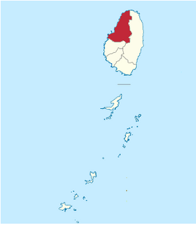
WCharlotte is the largest parish of Saint Vincent and the Grenadines, situated on the eastern coast of the island of Saint Vincent. With an area of 149 km², its size is comparable to that of the British Virgin Islands.) The parish has the longest coastline of all the parishes and is also larger than the three smallest parishes combined. The parish possesses a very rough and rugged topography with very little flat land occurring towards the coast. as a result of these features, parts of the north of the parish cannot be accessed by a main road. Up until the building of a bridge over the Rabacca Dry River access to the north side of the river was not possible when rain caused the river to swell and make the path impassable.
WChateaubelair is a large fishing village on the Leeward (west) coast of the Caribbean island of Saint Vincent, the main island of Saint Vincent and the Grenadines. It is located just south of the volcano of Soufrière. Commonly referred to as just "Chateau", it is the focus and largest community in the North Leeward constituency of St. Vincent, and the fourth largest town in the country.
WClare Valley is a town on the southwestern coast of Saint Vincent, in Saint Vincent and the Grenadines. It is located to the northwest of the capital, Kingstown, and southeast of Layou.
WClifton is a town located on Union Island, which is part of the Grenadines island chain of Saint Vincent and the Grenadines. It is located on the island's southeast coast.
WColonarie is a town in the east of the island of Saint Vincent in Saint Vincent and the Grenadines. It stands on the banks of the Colonarie River five kilometres to the south of Georgetown.
WCumberland is a village in Saint Vincent and the Grenadines. It is located in the west of the main island of Saint Vincent, between the towns of Barrouallie and Chateaubelair, and just to the south of the small settlement of Troumaka.
WDerrick is a town located on the island of Bequia, which is part of the Grenadines island chain.
WDiamond Village is a small farming village on the windward side of St. Vincent, the main island of the archipelago nation of Saint Vincent and the Grenadines.
 W
WE.T. Joshua Airport (ICAO: TVSV), formerly known as Arnos Vale Airport, is a decommissioned airport located in Arnos Vale, near Kingstown, on Saint Vincent island. The airport was named for Ebenezer Theodore Joshua, the first chief minister of Saint Vincent and the Grenadines. The Airport was a hub for Grenadine Airways, Mustique Airways and S.V.G. Air.
WFancy is the northernmost settlement in both the island of Saint Vincent and in the nation of Saint Vincent and the Grenadines. It is located on the coast close to the country's northernmost point. The town of Owia lies to the southeast of Fancy.
WGeorgetown is a town located on the island of Saint Vincent. It is the only town in Charlotte Parish with a populace numbering about 1,700.
WGrand Bonhomme is a mountain in the south of the island of Saint Vincent in Saint Vincent and the Grenadines. It rises to a height of 973 m (3,192 ft).
WGreiggs is a town in eastern inland Saint Vincent, in Saint Vincent and the Grenadines. It is located to the northwest of Biabou and northeast of Richland Park.
 W
WGrenadines is an administrative parish of Saint Vincent and the Grenadines, comprising the islands of the Grenadines other than those belonging to Grenada. The capital is Port Elizabeth.Area: 44 km² (17 mi²) Population: 9,200
WLovell Village is a town located on the island of Mustique, which is part of the Grenadines island chain. It is part of Saint Vincent and the Grenadines and is an administrative area of the country. Ferry service from St. Vincent is available.
WThe Martinique Channel is a strait in the Caribbean Sea that separates Saint Vincent and the Grenadines from Grenada.
 W
WMayreau is the smallest inhabited island of the Grenadines, with an area of about 0.46 sq. miles and a population of about 271. The population is centered in an unnamed village, located on Station Hill, a hilltop in the south-west of the island. It is an isolated community, accessible only by boat. Electricity was only recently (2002) provided by a central generator located on Saline Bay. There is a single-lane concrete road leading from the wharf on Saline Bay through the village to Saltwhistle Bay. The top of the island is crested with the small elementary school; the telecommunications building; the brick and stone Catholic Church of the Immaculate Conception, christened on May 12, 1930, and a Pentecostal church. From the crest of the hill behind the Catholic Church, there is an overlook of the Tobago Cays, Canouan and Union Island.
WMesopotamia is a town in eastern inland Saint Vincent, in Saint Vincent and the Grenadines. It is located to the southeast of Richland Park, and to the west of Peruvian Vale.
WNew Sandy Bay Village is a village in Charlotte Parish, Saint Vincent and the Grenadines. The village is located on the north shore of the island of Saint Vincent at only 62 feet above sea level.
WOwia is a town in Saint Vincent and the Grenadines. It is located in the northeast of the main island of Saint Vincent, close to the nation's northernmost point, Porter Point.
 W
WPalm Island in the Grenadines is a small island one mile from Union Island, only accessible by boat. It has an area of 135 acres (0.55 km2) and has five beaches.
 W
WSaint Vincent and the Grenadines is divided into six parishes.
WPeruvian Vale is a village in southeastern Saint Vincent, in Saint Vincent and the Grenadines. It is located to the east of the capital, Kingstown, at the northern end of Argyle Beach. Peruvian Vale lies on the coast road linking the capital with Georgetown, Saint Vincent and the Grenadines in the island's northeast. Peruvian Vale lies to the north of Stubbs, and south of Adelphi and Biabou.
WPetite Canouan is one of the Grenadines islands which lie between the Caribbean islands of Saint Vincent and Grenada. Politically, it is part of the nation of Saint Vincent and the Grenadines. Its area is approximately 0.15 km2. The island has wildlife refuge status and hosts Petit Canouan Wildlife Reserve.
WPetit Nevis is a small, privately owned island in the Grenadines, off the coast of Bequia. The island is uninhabited but is used by whalers to flense their catches, but that practice is now limited both by law to conserve the whale population as an endangered species.
WPigeon Island is one of the Grenadines uninhabited islands of Lesser Antilles in the Caribbean, part of the nation of Saint Vincent and the Grenadines. It is about 400 meters southwest of the larger Isle à Quatre. In 1987, it received the status of the Pigeon Island Wildlife Reserve.
 W
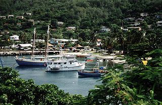
WPort Elizabeth is a town located on the island of Bequia, which is part of the Grenadines island chain. It is the capital of Grenadines Parish.
 W
WQuatre is one of the Grenadines islands which lie between the Caribbean islands of Saint Vincent and Grenada. It is part of the nation of Saint Vincent and the Grenadines.
WQuestelles is a town in Saint Andrew Parish, Saint Vincent and the Grenadines.
WRichland Park is a village in Charlotte Parish on the island of Saint Vincent in Saint Vincent and the Grenadines. It is located to the northwest of Mesopotamia, to the west of Biabou, and to the southwest of Greiggs.
WRose Bank is a town in Saint David Parish in Saint Vincent and the Grenadines. It is located on the west coast of the main island of Saint Vincent, to the north of Kingstown, just to the west of Chateaubelair, and northwest of Rose Hall.
WRose Hall at 1142 feet is the highest settlement in St. Vincent and the Grenadines. It is located in Saint David Parish on the island of Saint Vincent in Saint Vincent and the Grenadines. It is located to the east of Westwood, south of Rose Bank, just to the north of Spring Village and far west of Byera on the windward coast. It is uniquely positioned for pictures of La Soufriere volcano. St Lucia across the ocean. The mountain range and ships in the Caribbean Sea. It has a rich cultural heritage,organic farms with and it is one area that any plant in the hemisphere grows. It has a strong communal spirit and it hospitality knows no boundaries. It is one,if not the safest stop to visit on the island.
 W
WSaint Andrew is an administrative parish of Saint Vincent and the Grenadines, on the island of Saint Vincent. Its capital is Layou.Area: 29 km² (11 mi²) Population: 6,700
 W
WSaint David is an administrative parish of Saint Vincent and the Grenadines, on the island of Saint Vincent. Its capital is Chateaubelair.Area: 80 km² (31 mi²) Population: 6,700
 W
WSaint Patrick is an administrative parish of Saint Vincent and the Grenadines, on the island of Saint Vincent. The parish consists of the middle portion of the leeward side of the main island. Its capital is Barrouallie.Area: 37 km² (14 mi²) Population: 5,800
 W
WSaint Vincent Passage is a strait in the Caribbean, that separates the Saint Lucia and Saint Vincent. It is a pathway between Caribbean sea and Atlantic ocean.
WSavan is one of the Grenadine islands which lie between the Caribbean islands of Saint Vincent and Grenada. Politically, it is part of the nation of Saint Vincent and the Grenadines.
 W
WLa Soufrière or Soufrière Saint Vincent is an active volcano on the island of Saint Vincent in the Windward Islands of the Caribbean. Many volcanoes in the Caribbean are named Soufrière. These include Soufrière Hills on Montserrat and La Grande Soufrière on Guadeloupe, the subject of Werner Herzog's 1977 film La Soufrière.
WSpring Village is a village in Saint Patrick Parish on the island of Saint Vincent in Saint Vincent and the Grenadines. It is located to the southeast of Westwood, just to the south of Rose Hall.
WStation Hill is a town located on the island of Mayreau, which is part of the Grenadines island chain.
WStubbs is a village in Saint George Parish on the island of Saint Vincent in Saint Vincent and the Grenadines. It is located to the east of the capital, Kingstown, at the southern end of Argyle Beach. Stubbs lies on the coast road linking the capital with Georgetown, Saint Vincent and the Grenadines in the island's northeast. The next village to the north of Stubbs is Calder Peruvian Vale.
WTroumaka (Troumaca) is a village in Saint David Parish in Saint Vincent and the Grenadines. It is located in the west of the main island of Saint Vincent, between the larger towns of Barrouallie and Chateaubelair, and just to the north of the small settlement of Cumberland.
WVermont is a town in Saint Andrew Parish of Saint Vincent and the Grenadines. It is located in the inland southwest of the main island of Saint Vincent, north of Kingstown and east of Layou.
 W
WThe Wallilabou River is a river in the northwest of Saint Vincent. It rises in the Grand Bonhomme Mountains in the centre of the island and flows Northwest to reach the Caribbean Sea North of Barroulie.The Wallilabou Falls-a tourist attraction-is located on this river, a short walk Northeast along the Leeward Highway. Several of the scenes from the film Pirates of the Caribbean: The Curse of the Black Pearl were filmed close to the mouth of the river.
 W
WYoung Island is one of the smallest islands of Grenadines and part of the state St. Vincent and the Grenadines. It lies immediately south of St. Vincent island, separated from it by a channel approximately 180 m (590 ft) wide. The name goes back to the former British Governor of St. Vincent William Young.