 W
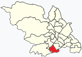
WBeauchief and Greenhill ward—which includes the districts of Batemoor, Beauchief, Chancet Wood, Greenhill, Jordanthorpe, and Lowedges—is one of the 28 electoral wards in City of Sheffield, England. It is located in the southern part of the city and covers an area of 2.4 square miles (6.2 km2). The population of this ward in 2016 was estimated to be 19,669 people in 9,209 houses.
 W
WDore and Totley ward—which includes the districts of Bradway , Dore, Totley, and Whirlow—is one of the 28 electoral wards in City of Sheffield, England. It is currently represented by three Liberal Democrat councillors. It is located in the southwestern part of the city and covers an area of 26.3 km2. The population of this ward in 2001 was 16,404 people in 7,037 households. Dore and Totley ward is one of the five wards that make up the Sheffield Hallam Parliamentary constituency. The population of Dore and Totley is 16,740 (2011) with 7,334 Households.
 W
WNether Edge and Sharrow Ward includes the districts of Brincliffe, Carter Knowle, Nether Edge, Sharrow Vale, and most of Banner Cross, and is one of the 28 electoral wards in the City of Sheffield, England. It is located in the southern part of the city and covers an area of 1.31 square miles (3.4 km2). In 2011, the population of this ward was 18,890 people in 7,592 households. Nether Edge ward is one of the wards that make up the Sheffield Central parliamentary constituency.
 W
WBroomhill and Sharrow Vale — which includes the districts of Broomhill, Broomhall, Crookesmoor, Endcliffe, Sharrow Vale and Tapton Hill — is one of the 28 electoral wards in City of Sheffield, England. The ward was created following the 2015 local government boundary review out of parts of the old Broomhill, Central and Nether Edge wards. It is located in the western part of the city. The population of the Broomhill ward in 2011 was 16,966 people in 5,708 households, covering an area of 2.7 km2. Broomhill & Sharrow Vale is one of the wards that make up the Sheffield Central Parliamentary Constituency.
 W
WBurngreave is an inner city district of Sheffield, South Yorkshire, England lying north of the city centre. The population of the ward taken at the 2011 census was 27,481. It started to develop in the second half of the 19th century. Prior to this, this area was mostly covered by Burnt Greave wood. Most of the area of the wood is covered by Burngreave Cemetery which was built in 1860 and extended in the early 1900s. Grimesthorpe Lane, which runs through Burngreave, is a very old road that follows the course of the Roman Rig, a man-made defensive ridge—probably built by the Celtic Brigantes tribe—that used to run from near the Wicker to Mexborough.
WNether Edge and Sharrow Ward includes the districts of Brincliffe, Carter Knowle, Nether Edge, Sharrow Vale, and most of Banner Cross, and is one of the 28 electoral wards in the City of Sheffield, England. It is located in the southern part of the city and covers an area of 1.31 square miles (3.4 km2). In 2011, the population of this ward was 18,890 people in 7,592 households. Nether Edge ward is one of the wards that make up the Sheffield Central parliamentary constituency.
 W
WChapeltown is a large village and suburb of Sheffield in South Yorkshire, England. It is part of the Parish of Ecclesfield. It is historically within the West Riding of Yorkshire.
WCrookes is a suburb of the City of Sheffield, England, about 1.5 miles (2.4 km) west of the city centre. It borders Broomhill to the south, Walkley and Crookesmoor to the east and open countryside around the River Rivelin to the north. The population of the ward of the same name was 17,700 at the 2011 Census.
WBroomhill and Sharrow Vale — which includes the districts of Broomhill, Broomhall, Crookesmoor, Endcliffe, Sharrow Vale and Tapton Hill — is one of the 28 electoral wards in City of Sheffield, England. The ward was created following the 2015 local government boundary review out of parts of the old Broomhill, Central and Nether Edge wards. It is located in the western part of the city. The population of the Broomhill ward in 2011 was 16,966 people in 5,708 households, covering an area of 2.7 km2. Broomhill & Sharrow Vale is one of the wards that make up the Sheffield Central Parliamentary Constituency.
WCrosspool is a suburb of the City of Sheffield, South Yorkshire, England, located 2.5 miles (4 km) west of the city centre. The suburb falls within the Crookes ward of the City of Sheffield. It is a middle class residential area in an elevated position above the Porter and Rivelin valleys and stands at around 660 feet (200 m) above sea level. Crosspool is situated on the A57 road and is the last suburb on that road before the city boundary and open countryside is reached. In 2011 Crosspool had a population of 6,703.
 W
WDarnall is a suburb of eastern Sheffield, South Yorkshire, England. Darnall is approximately 3 miles (5 km) east-north-east of Sheffield city centre.
WBroomhill and Sharrow Vale — which includes the districts of Broomhill, Broomhall, Crookesmoor, Endcliffe, Sharrow Vale and Tapton Hill — is one of the 28 electoral wards in City of Sheffield, England. The ward was created following the 2015 local government boundary review out of parts of the old Broomhill, Central and Nether Edge wards. It is located in the western part of the city. The population of the Broomhill ward in 2011 was 16,966 people in 5,708 households, covering an area of 2.7 km2. Broomhill & Sharrow Vale is one of the wards that make up the Sheffield Central Parliamentary Constituency.
 W
WBurngreave ward—which includes the districts of Burngreave, Fir Vale, Grimesthorpe, Pitsmoor, and Shirecliffe—is one of the 28 electoral wards in City of Sheffield, England. It is located in the northern part of the city and covers an area of 2.8 square miles. The population of this ward in 2011 was 27,481 people in 9,906 households. It is one of the wards that make up the Sheffield, Brightside and Hillsborough constituency. Most of the ward is served by a free community newspaper, the Burngreave Messenger.
 W
WFulwood is a residential suburb and ward of the City of Sheffield in England, it lies 5.5 km west-southwest of the city centre. Formerly an ancient settlement and village on the Porter Brook, it became integrated into the city in the 1930s. It is bounded by the suburbs of Lodge Moor to the NW, Ranmoor to the east and Crosspool to the NE. The open countryside of the Peak District lies to the west and SW. The sub districts of Stumperlowe and Goole Green are part of the suburb. The population of the ward at the 2011 Census was 18,233. Fulwood is located in the Sheffield Hallam constituency which, as of the 2019 general election voted Labour.
WGleadless is a suburb and parish within the City of Sheffield, it lies five km south east of the city centre. It is bordered by the adjoining suburbs of Gleadless Valley to the west, Frecheville to the east and Intake to the north. The land to the south is the rural area of North East Derbyshire district which is outside the city boundary. Gleadless was formerly a country hamlet, then village before becoming part of the expanding city of Sheffield in 1921. The word Gleadless comes from the Old English language and means either “forest clearings haunted by a kite” or “bright clearing”.
WBeauchief and Greenhill ward—which includes the districts of Batemoor, Beauchief, Chancet Wood, Greenhill, Jordanthorpe, and Lowedges—is one of the 28 electoral wards in City of Sheffield, England. It is located in the southern part of the city and covers an area of 2.4 square miles (6.2 km2). The population of this ward in 2016 was estimated to be 19,669 people in 9,209 houses.
WGrenoside is a suburb of Sheffield, South Yorkshire, England. The suburb falls within the West Ecclesfield ward of the city.
 W
WEcclesall Ward—which includes the neighbourhoods of Bents Green, Ecclesall, Greystones, Millhouses, and Ringinglow—is one of the 28 electoral wards in City of Sheffield, England. It is located in the southwestern part of the city and covers an area of 3.6 square miles. The population of this ward in 2007 was 19,211 people in 7,626 households, reducing to 6,657 at the 2011 Census. Ecclesall ward is one of the four wards that make up the South West Community Assembly and one of five wards that make up the Sheffield Hallam Parliamentary constituency. The Member of Parliament is Olivia Blake, a Labour MP. Ecclesall is one of the least socially deprived wards in the entire country, with a 2002 deprivation score of 4.7—making it the 8,105th most deprived ward out of 8,414 wards in the country. The demographic consists largely of white, middle-class families.
WBurngreave ward—which includes the districts of Burngreave, Fir Vale, Grimesthorpe, Pitsmoor, and Shirecliffe—is one of the 28 electoral wards in City of Sheffield, England. It is located in the northern part of the city and covers an area of 2.8 square miles. The population of this ward in 2011 was 27,481 people in 9,906 households. It is one of the wards that make up the Sheffield, Brightside and Hillsborough constituency. Most of the ward is served by a free community newspaper, the Burngreave Messenger.
WBurngreave ward—which includes the districts of Burngreave, Fir Vale, Grimesthorpe, Pitsmoor, and Shirecliffe—is one of the 28 electoral wards in City of Sheffield, England. It is located in the northern part of the city and covers an area of 2.8 square miles. The population of this ward in 2011 was 27,481 people in 9,906 households. It is one of the wards that make up the Sheffield, Brightside and Hillsborough constituency. Most of the ward is served by a free community newspaper, the Burngreave Messenger.
 W
WMosborough is an electoral ward of the City of Sheffield, England, in the eastern part of the city, on the border with Rotherham. The population in 2011 was 17,097. It is one of the wards that make up the Sheffield South East constituency.
WHandsworth is a suburb of south eastern Sheffield, in South Yorkshire, England. It covers an area of approximately 5 square miles (13 km2), and has a population of approximately 15,000. It has five schools, four churches, a variety of small shops, a large supermarket, and a range of commercial and light industrial businesses. The area is signposted from M1 Junction 31.
 W
WGleadless Valley ward—which includes the districts of Gleadless Valley, Heeley, Lowfield, and Meersbrook—is one of the 28 electoral wards in City of Sheffield, England. It is located in the southern part of the city and covers an area of 4.5 km2. The population of this ward in 2011 was 21,089 people in 9,516 households. It is one of the five wards that form the Sheffield Heeley parliamentary constituency whose Member of Parliament elected at the 2001 general election was Meg Munn. Gleadless Valley actually describes the valley that separates Hemsworth from Herdings, and is a broad area that covers several housing estates: Hemsworth, Herdings and Rollestone. Gleadless Valley is bordered by Gleadless and Norton.
 W
WHigh Green is the northernmost suburb of Sheffield, England, located about 8 miles from the city centre. It is found to the north of Chapeltown and is served by a number of buses; the nearest rail station is in Chapeltown 1 mile away. The suburb falls within the West Ecclesfield ward of the city Council.
 W
WCity ward — which includes the districts of Highfield, Kelham Island and the city centre — is one of the 28 electoral wards in City of Sheffield, England. It covers the central area of the city. The ward was created following the 2015 local government boundary review out of part of the old Central ward, which, with a population of 36,412, was the largest ward in the UK. City is one of the wards that make up the Sheffield Central constituency.
WBeauchief and Greenhill ward—which includes the districts of Batemoor, Beauchief, Chancet Wood, Greenhill, Jordanthorpe, and Lowedges—is one of the 28 electoral wards in City of Sheffield, England. It is located in the southern part of the city and covers an area of 2.4 square miles (6.2 km2). The population of this ward in 2016 was estimated to be 19,669 people in 9,209 houses.
 W
WFulwood ward—which includes the districts of Fulwood, Lodge Moor, and Ranmoor—is one of the 28 electoral wards in City of Sheffield, England. It is located in the far western part of the city and covers an area of 23.2 km2. The population of this ward in 2011 was 18,233 people in 6,476 households. Fulwood ward is one of the five wards that make up the Sheffield Hallam Parliamentary constituency. In the 2004 local elections John Knight, Janice Sidebottom, and Andrew Sangar, all Liberal Democrats, were returned as councillors for the newly drawn ward. The current Member of Parliament is Labour's Olivia Blake.
 W
WLongley is a suburb of the City of Sheffield, in South Yorkshire, England. It lies four km north of the city centre and is a residential neighbourhood made up mostly of housing built by Sheffield City Council in the late 1920s. The suburb falls within the Firth Park ward of the City.
WGleadless Valley ward—which includes the districts of Gleadless Valley, Heeley, Lowfield, and Meersbrook—is one of the 28 electoral wards in City of Sheffield, England. It is located in the southern part of the city and covers an area of 4.5 km2. The population of this ward in 2011 was 21,089 people in 9,516 households. It is one of the five wards that form the Sheffield Heeley parliamentary constituency whose Member of Parliament elected at the 2001 general election was Meg Munn. Gleadless Valley actually describes the valley that separates Hemsworth from Herdings, and is a broad area that covers several housing estates: Hemsworth, Herdings and Rollestone. Gleadless Valley is bordered by Gleadless and Norton.
WLoxley is a village and a suburb of the city of Sheffield, England. It is a long linear community which stretches by the side of the River Loxley and along the B6077 for almost 2.5 miles (4 km). Loxley extends from its borders with the suburbs of Malin Bridge and Wisewood westward to the hamlet of Stacey Bank near Damflask Reservoir. The centre of the suburb is situated at the junction of Rodney Hill and Loxley Road where the old village green stands and this is located 3 miles (5 km) north west of Sheffield city centre. The suburb falls within the Stannington ward of the City of Sheffield.
WMalin Bridge is a suburb of the city of Sheffield, England. It is located at grid reference SK325893 and stands 2½ miles north-west of the city centre where the rivers Loxley and Rivelin meet. Malin Bridge is only a small district centred on the road bridge over the River Loxley which carries the B6076 road to Stannington ; it is surrounded by the suburbs of Hillsborough, Wisewood, Walkley and Stannington.
WMeersbrook is a suburban district in the south-west of Sheffield, England bordered by Nether Edge to the west, Norton Lees to the south, Heeley to the north and the Meersbrook allotment site to the east. Until 1950 it was part of the Sheffield Ecclesall constituency and now forms part of the Sheffield Heeley constituency. The district falls within the Gleadless Valley ward of the city. The name comes from the stream, the Meers Brook, a tributary of the River Sheaf which means 'boundary brook' and in ancient times this, along with the River Sheaf formed the boundary between the Anglo-Saxon kingdoms of Northumbria and Mercia. It remained as the boundary between Yorkshire and Derbyshire into the 20th century. Meersbrook itself was once several small communities which have given many roads their names; Rush Dale, Carfield & Cliffe Field and in 1857 was known as Mears Brook.
WMiddlewood is a north western suburb of Sheffield, South Yorkshire, England. The suburb falls within the Stannington ward of the City.
WMillhouses is a neighbourhood in the City of Sheffield, England. It is located in Ecclesall ward; in the south-western portion of the city on the northwest bank of the River Sheaf. Its origins lie in a small hamlet that grew around the Ecclesall Corn Mill. It has a population of 4,424.
WNeepsend is a suburb of the city of Sheffield, it stands just 1 mile (1.6 km) north-west of the city centre. The main area of Neepsend covers the flood plain of the River Don from Lady's Bridge at the Wicker up to Hillfoot Bridge. The suburb falls within the Central Ward of the City. The adjacent district of Parkwood Springs is often regarded as part of the suburb.
WNether Edge and Sharrow Ward includes the districts of Brincliffe, Carter Knowle, Nether Edge, Sharrow Vale, and most of Banner Cross, and is one of the 28 electoral wards in the City of Sheffield, England. It is located in the southern part of the city and covers an area of 1.31 square miles (3.4 km2). In 2011, the population of this ward was 18,890 people in 7,592 households. Nether Edge ward is one of the wards that make up the Sheffield Central parliamentary constituency.
WNetherthorpe is a suburb of the City of Sheffield in England. It is one mile (1.6 km) west of the city centre. It is mostly an area of local government built housing situated on a considerable slope running downhill from the Brook Hill roundabout at a height of 107 metres towards the Shalesmoor roundabout at a height of 51 Metres over a distance of one kilometre. It is bounded by the suburbs of Upperthorpe to the north, Crookesmoor to the west and the dualled Inner Ring Road to the east. The suburb falls within the Walkley ward of the City.
WNorton Lees is a residential suburb in the Graves Park ward of the City of Sheffield, England located to the east of Woodseats.
 W
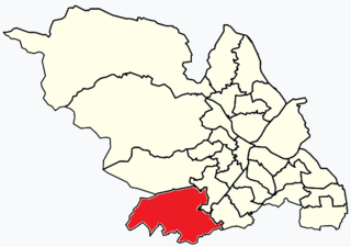
WGraves Park ward—which includes the districts of Norton, Norton Lees, Norton Woodseats, and Woodseats—is one of the 28 electoral wards in City of Sheffield, England. It is located in the southern part of the city and covers an area of 5.8 km2. The population of this ward in 2011 was 16,705 people in 7,464 households. It is one of the five wards that form the Sheffield Heeley parliamentary constituency whose Member of Parliament elected at the 2001 general election was Meg Munn. The districts of this ward were in the historic county of Derbyshire, but they have now been absorbed into the metropolitan borough of Sheffield, thus placing them in the ceremonial county of South Yorkshire.
WBurngreave ward—which includes the districts of Burngreave, Fir Vale, Grimesthorpe, Pitsmoor, and Shirecliffe—is one of the 28 electoral wards in City of Sheffield, England. It is located in the northern part of the city and covers an area of 2.8 square miles. The population of this ward in 2011 was 27,481 people in 9,906 households. It is one of the wards that make up the Sheffield, Brightside and Hillsborough constituency. Most of the ward is served by a free community newspaper, the Burngreave Messenger.
WOwlerton is a suburb of the city of Sheffield, it lies 2.2 miles (3.5 km) northwest of the city centre near the confluence of the River Don and River Loxley. Owlerton was formerly a small rural village with its origins in the Early Middle Ages; it became part of Sheffield in the early 1900s as the city expanded. Owlerton stands just east of the adjacent suburb of Hillsborough and the division between the two districts is difficult to delineate. The suburb falls within the Hillsborough ward of the city. This is further complicated by the fact that certain buildings such as Hillsborough Stadium, Hillsborough Leisure Centre and Hillsborough College lie firmly within Owlerton. The name Owlerton is believed to come from the abundant growth of alder trees in the area
WPitsmoor is a former village, now a suburb of Sheffield, England. The name derives from Or-pits as, anciently, the main local industry was the mining of ore. The village falls within the Burngreave ward of the City.
 W
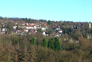
WRanmoor is a suburb of the City of Sheffield, England. It is an affluent suburb in the Fulwood ward of the city. It mostly developed in the late 19th and early 20th centuries, and it features a number of large houses that were built for the city's steel magnates, as well as, most notably, a large church, St John's. This church was opened 24 April 1879 but was almost entirely destroyed by fire on 2 January 1887. All that survived from the original church was the tower and spire, which still stands today. A new building was built and the church reopened on 9 September 1888; it is now a Grade II* listed building. A row of early 19th century buildings near the church includes the Bull's Head and Ranmoor Inn public houses.
WSharrow is a district of Sheffield directly southwest of Sheffield city centre. The district is in the Broomhill ward of the City.
WBurngreave ward—which includes the districts of Burngreave, Fir Vale, Grimesthorpe, Pitsmoor, and Shirecliffe—is one of the 28 electoral wards in City of Sheffield, England. It is located in the northern part of the city and covers an area of 2.8 square miles. The population of this ward in 2011 was 27,481 people in 9,906 households. It is one of the wards that make up the Sheffield, Brightside and Hillsborough constituency. Most of the ward is served by a free community newspaper, the Burngreave Messenger.
 W
WStannington is a suburb in the City of Sheffield, England. The area is located in the civil parish of Bradfield, and is in the electoral ward of Stannington. Stannington is situated right on the western edge of the Sheffield urban area
 W
WTinsley is a suburb of northeastern Sheffield, South Yorkshire, England. The suburb falls within the Darnall ward of the City.
WTotley is a suburb on the extreme southwest of the City of Sheffield, in South Yorkshire, England. Lying in the historic county boundaries of Derbyshire, Totley was amalgamated into the city of Sheffield in 1933, and is today part of the Dore and Totley electoral ward in the city, though it remains close to the contemporary county boundary of Derbyshire. Totley had a population of 7,963 in 2011. Totley was shown at the 2011 census as being part of the ward of Dore and Totley.
WUpperthorpe is a suburb of the City of Sheffield, England. It lies 1.2 miles (2 km) west of the city centre. The suburb falls within the Walkley ward of the City. It is an area of residential housing and is bounded by the suburbs of Walkley to the north, Crookes to the west and Netherthorpe to the south.
WWadsley is a suburb of the City of Sheffield in South Yorkshire, England. It stands 3 miles (5 km) north-west of the city centre at an approximate grid reference of SK321905. At the 2011 Census the suburb fell within the Hillsborough ward of the City. Wadsley was formerly a rural village which was engulfed by the expansion of Sheffield in the early part of the 20th century.
WWadsley Bridge is a suburb of Sheffield, South Yorkshire, England, 3 miles (4.8 km) northwest of the city centre. The area is a mixture of residential housing and small industrial and commercial premises. The suburb falls within the Hillsborough ward of the City.
WWalkley is a suburb in the north west of Sheffield in England. It lies west of Burngreave, south of Hillsborough and north-east of Crookes.
WThe West End is a loosely defined area of Sheffield, consisting of part of the City Centre, in addition to some of the western suburbs. The term has been in use for at least 150 years.
WWhirlow is a suburb of the City of Sheffield in England, it lies 3.7 miles (6 km) south-west of the city centre. The suburb falls within the Dore and Totley ward of the City. It is one of the most affluent areas of Sheffield, with much high class housing and several notable small country houses within it. During the Victorian era it was home to some of Sheffield's most influential citizens. Whirlow straddles the A625, the main Sheffield to Hathersage road. The suburb covers the area from Parkhead in the north to Whirlow Bridge in the south and from Ecclesall Woods in the east to Broad Elms Lane in the west. Whirlow had a population of 1,663 in 2011.
WWoodseats is a district of Sheffield, South Yorkshire in the Graves Park ward. Historically, Norton Woodseats was a village that straddled Derbyshire Lane running from Four Lane Ends to Bolehill, originally in Derbyshire but since 1901, part of the City of Sheffield.