 W
WAguas Blancas (Salta) is a village and rural municipality in Salta Province in northwestern Argentina. It is a city in the Oran department, located northeast of the province of Salta, Argentina. Aguas Blancas is located on the right bank of the Bermejo River, which forms a natural boundary between Argentina and Bolivia. The city Bermejo, Bolivia is on the opposite bank of the river.
 W
WAmpascachi is a village and rural municipality in Salta Province in northwestern Argentina.
 W
WAnimaná is a town and rural municipality in Salta Province in northwestern Argentina. At the 2001 census, the town had 1454 residents. Animaná means "sky place" in the Cacán language.
 W
WAntilla is a village and rural municipality in Salta Province in northwestern Argentina. It is located southeast of the city of Rosario de la Frontera through National Route 34 at km 931.
 W
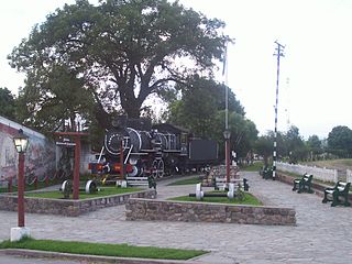
WApolinario Saravia (Salta) is a town and municipality in Salta Province in northwestern Argentina.
The Baritú National Park is a national park in Argentina, located in the Santa Victoria Department, in the north of the province of Salta, in the Argentine Northwest. The park borders Bolivia, and its only road access is through that country. It has an area of 720 square kilometres (72,000 ha) and it is the only tropical park in Argentina.
 W
WCabra Corral is a small village and rural municipality in Salta Province in northwestern Argentina. It has only 25 inhabitants. Population numbers have decreased since the last census.
 W
WCachi is a department in the east of Salta Province, Argentina. Its capital is the town of Cachi.
 W
WCampo Quijano is a town and municipality in Salta Province in northwestern Argentina.
 W
WCerrillos is a department of Salta Province, Argentina, located near Salta city. Its capital is the town of Cerrillos.
WCerrillos is a city in the province of Salta, Argentina. It has about 18,000 inhabitants as per the 2001 census [INDEC], and it is the head town of the Cerrillos Department. It is located just 15 km south of the city of Salta, capital of the province.
 W
WColomé is a village and rural municipality in Salta Province in northwestern Argentina.
 W
WCoronel Cornejo is a town and municipality in Salta Province in northwestern Argentina.
 W
WCoronel Moldes (Salta) is a town and municipality in Salta Province in northwestern Argentina.
 W
WEl Galpón (Salta) is a town and municipality in Salta Province in northwestern Argentina.
 W
WThe El Rey National Park is a national park of Argentina, located in the Anta Department, province of Salta, in the Argentine Northwest, 80 km from the provincial capital. It has an area of 441.62 km².
 W
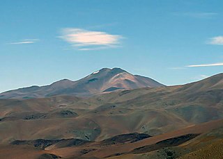
WCerro Escorial is a stratovolcano at the border of Argentina and Chile. It is part of the Corrida de Cori volcanic group and its youngest member. A well-preserved 1-kilometre-wide (0.6 mi) crater forms its summit area. Lava flows are found on the Chilean and smaller ones on the Argentinian side, the former reaching as far as 3–4 kilometres (1.9–2.5 mi) from the volcano. One of these is dated 342,000 years ago by argon-argon dating.
 W
WGeneral Güemes, sometimes shortened in Güemes, is a town in the center of the province of Salta, Argentina. It has 47,348 inhabitants as per the 2010 census [INDEC], and is the head town of the General Güemes Department.
 W
WGeneral Mosconi (Salta) is a town and municipality in Salta Province in northwestern Argentina.
 W
WThe Río Grande de Tarija is a river of Argentina and Bolivia. It is a tributary of the Bermejo River. It is also known as the Río Tarija and the Tarija River.
 W
WGuachipas is a village and rural municipality in Salta Province in northwestern Argentina.
 W
WIruya is a small town of population 1,070 in northwestern Argentina. It is located in the Salta Province of northwestern Argentina, and is the capital of the Iruya Department.
 W
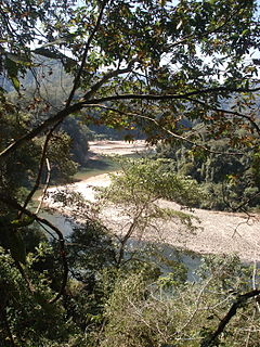
WThe Iruya River is a river of Argentina. It is a tributary of the Pescado River.
 W
WJoaquín V. González is a town and municipality in Salta Province in northwestern Argentina.
WLa Caldera is a small town and municipality in Salta Province in northwestern Argentina. It is located 25 km north of the city of Salta.
 W
WLa Merced is a town and municipality in Salta Province in northwestern Argentina.
 W
WLas Lajitas is a town and municipality in Anta department, Salta Province in northwestern Argentina. It is about 230 km from the capitol by Ruta National 34 and then by RP 272. It also belongs to Área Agroecológica Chaco Semiárido. It produces cereals, beans, oil and wood. The rain level is about 600–800 mm between October and May.
 W
WThe Los Cardones National Park is a national park of Argentina, located in the center-west of the province of Salta, within the San Carlos and Cachi Departments, in the Argentine Northwest.
 W
WLos Toldos (Salta) is a village and rural municipality in Salta Province in northwestern Argentina.
WMisión Kilómetro 6 is a village and rural municipality in Salta Province in northwestern Argentina.
 W
WMolinos is a village and rural municipality in Salta Province in northwestern Argentina.
 W
WNevado de Cachi is the name given to a large complex of mountains that lies in Salta Province, Argentina. This complex counts several summits, the highest being 6,380m and it is called Cumbre Libertador. This summit was climbed for the first time in 1950. The mountains overlook Cachi, a traditional village of Northern Argentina. The main summit is rarely climbed and the secondary summits even less. Some of them have been climbed only once. The mountain can be climbed, in favourable weather conditions, in five days by a party fully acclimatised to an altitude of 4,000m. The quality of the rock is almost everywhere poor, there is permanent snow but almost no glacier. Climbing interest is little but the area is of outstanding beauty. Almost all routes are easy but rockfalls are common. In summer the snow-line is about at 5,800m; in winter it is significantly lower making possible some technical climbs. The region experiences the same seasons of Bolivia, summers are dry but winter can be very rainy with heavy snowfalls. Wind is probably the main hazard and should be not underestimated.
 W
WNevado de Chañi is a mountain in the Andes of the Jujuy Province in Argentina. It has a height of 5,949 metres. It lies at about 50 km northwest of San Salvador de Jujuy.
 W
WNevado de Palermo is a mountain in the Andes Mountains of Argentina. It is also sometimes known as Morro del Quemado. It has a height of 6,172 metres (20,249 ft).
 W
WNevado Queva is a volcano in the Andes mountain range of South America, located in the Salta Province of Argentina. Queva has a summit elevation of 6,140 metres (20,144 ft) above sea level. It is the 4th highest peak in the province of Salta. Its name is alternately spelled Quehuar or Quewar. There are quite extensive ruins on the summit of the mountain, which is a broad crater.
 W
WOlacapato is a village and rural municipality in Salta Province in northwestern Argentina. Olacapato is one of the highest towns in Argentina. The previous census of 2001 indicated a population of 186 inhabitants, appearing as a rural dispersed population.
 W
WPayogasta is a village and rural municipality in Salta Province in northwestern Argentina.
WPichanal is a town and municipality in Orán Department, located in northeastern Salta Province, Argentina. It is connected to the national road network by National Route 34, and to nearby San Ramón de la Nueva Orán by National Route 50. It has economic significance because of its position as a junction on these routes. It is within the bounds of the Yungas Biosphere Reserve.
WPluma de Pato is a village and rural municipality in Salta Province in northwestern Argentina.
 W
WThe Puna de Atacama or Atacama Plateau is an arid high plateau, in the Andes of northern Chile (15%) and Argentina (85%). Geomorphologist Walther Penck based his Grossfalt landform association on Puna de Atacama.
 W
WRecaredo is a village and rural municipality in Salta Province in northwestern Argentina. It is near General Mosconi, Salta, and its population relies on local petroleum extraction.
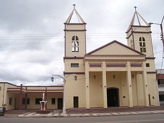
WRosario de la Frontera is a city in the center-south of the province of Salta, Argentina. It has 26,174 inhabitants as per the 2010 census [INDEC], and is the head town of the Rosario de la Frontera Department. It is located on National Route 9, by the Horcones River.
 W
WRosario de Lerma is a town in the center of the province of Salta, Argentina.
 W
WThe Rosario River is a river in Argentina.
 W
WSalín is a mountain in the Andes of Argentina. It has a height of 6029 metres.
 W
WSan Antonio de los Cobres is a small town of population 5,482 in northwestern Argentina. It is the capital of the Los Andes Department of the Salta Province.
 W
WSan Felipe is a village and rural municipality in Salta Province in northwestern Argentina.
 W
WSan Isidro de Iruya is a village and rural municipality in Salta Province in northwestern Argentina.
 W
WSan José de Metán is a city in the south of the province of Salta, Argentina, 160 km from the provincial capital Salta, on National Routes 9 and 34. It has about 28,000 inhabitants as per the 2010 census [INDEC]. It is the head town of the Metán Department.
 W
WSanta Rosa de Tastil is a rural municipality in Salta Province in northwestern Argentina.
 W
WSanta Victoria Este is a town in northeastern Salta Province in the Department of Rivadavia. According to the 2010 Census, it has a population of 1,283.
 W
WSanta Victoria Oeste is a municipality and head of the Santa Victoria Department, at the northwest corner of the province of Salta, Argentina, between mountains and valleys on the border with the Republic of Bolivia, 540 km from the city of Salta.
 W
WSeclantás is a small village located in north western Argentina, 150 km south west from Salta city.
 W
WTolar Grande is a village and rural municipality in Salta Province in northwestern Argentina.
 W
WTolombón is a village and rural municipality in Salta Province in northwestern Argentina. It is in the Cafayate department. It is 14 km south of Cafayate. Currently, only 255 people live there.
 W
WVilla San Lorenzo, commonly known simply as San Lorenzo, is a town and municipality in Salta Province in northwestern Argentina.