 W
WAvenida Brasil is an expressway-like thoroughfare in Rio de Janeiro. At 58.5 kilometres (36.4 mi), it is the biggest avenue in extension in Brazil, as well as the largest urban track of BR-101. Av. Brasil was first proposed in 1939 and was inaugurated 7 years later, and currently goes through 26 neighbourhoods of Rio de Janeiro.
 W
WThe Rodovia Estrada do Coco and Linha Verde, (BA-099), is a state highway which runs through the northeastern part of the state of Bahia and southeastern region of the state of Sergipe in Brazil. The road connects the city of Salvador, the capital of Bahia, to the city of Aracaju, the capital of Sergipe.
 W
WBandeirantes Avenue is one of the most important avenues of São Paulo, serving as one of the main access roads to the Congonhas Airport, as well as a link between Marginal Pinheiros highway and Rodovia Anchieta and Rodovia dos Imigrantes. The avenue had large truck traffic due to the export flow flowing through the Port of Santos, however, after August 2010, the movement of such vehicles on the road was restricted to the nighttime due to the conclusion of the south section of the Rodoanel Mário Covas. The avenue also serves as the southern boundary of the area known as the "expanded central zone." Bandeirantes Avenue originally was called Estrada da Traição. Traição stream was channeled into a pipeline and the avenue was built on top of this, hence its name.
 W
WBR-020 is a federal highway of Brazil. The 2038 kilometre road connects Fortaleza in Ceará to the federal capital Brasília.
 W
WBR-050 is a federal highway of Brazil. The 1025.3 kilometre road connects Brasília to Santos.
 W
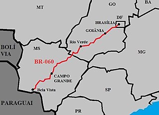
WBR-060 is a federal highway of Brazil. The 1459 kilometre road connects Brasilia to Bela Vista, on the Paraguayan border.
 W
WBR-070 is a federal highway of Brazil. The 1315 kilometre road connects Brasilia to Porto Corixó, Cáceres, Mato Grosso.
 W
WBR-104 is a federal highway of Brazil. The 672.3 kilometre road connects Macau to Maceió.
 W
WBR-110 is a federal highway of Brazil. The 1042 kilometre road connects Areia Branca to Catu.
 W
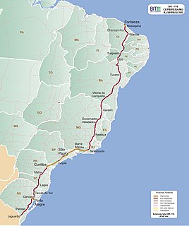
WBR-116 is a federal route of highways of Brazil. One of the most important highways in Brazil and the second longest, its 4,490 kilometres (2,790 mi) connect Fortaleza, Ceará, one of the largest Northeast Brazil metropolises, to the southern city of Jaguarão, Rio Grande do Sul, in the border with Uruguay. It is also the longest highway in the country to be completely paved.
 W
WBR-122 is a federal highway of Brazil. The 1801.9 kilometre road connects Chorozinho to Pernambuco.
 W
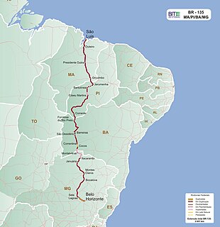
WBR-135 is a federal highway of Brazil. The 2657 kilometre road connects São Luís to Belo Horizonte.
 W
WBR-158 is a federal highway of Brazil. One of the longest highways in the country, the 3,946.2-kilometre (2,452.1 mi) road connects Altamira, Pará, to Santana do Livramento on the Uruguayan border where it joins Route 5 (Uruguay).
 W
WBR-163 is a highway in Brazil, going from Tenente Portela, in the state of Rio Grande do Sul, to Santarém, Pará, on 3579 kilometers. It was proposed to pave the road in its entirety part of the Avança Brasil project, which in 2007 was replaced by the Programa de Aceleração do Crescimento. A 51km long stretch of the highway was finally paved in 2019 in the state of Pará in a cooperation between the Bolsonaro government and the Brazilian army engineering battalion, until the city of Miritituba, leaving only a small part of the highway to be paved on the other side of the Amazon River.
 W
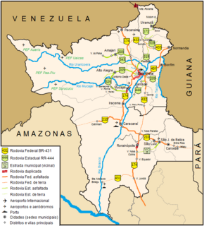
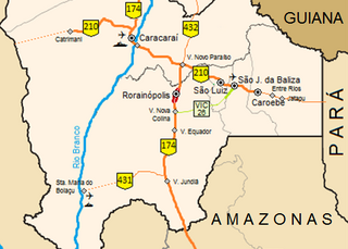
WBR-174 is a federal highway of Brazil. The 3,321 km (2,064 mi) road connects Cáceres to Pacaraima on the Venezuelan border. It is the only road connection of the state of Roraima with the rest of the country.
 W
WBR-210 is a federal highway of Brazil. The 411.7 kilometre road, popularly known as Perimetral Norte, is primarily located in the Northern Brazilian state of Roraima, with other segments in Amazonas, Pará, and Amapá.
 W
WBR-226 is a Brazilian federal highway that connects the cities of Natal, Rio Grande do Norte, and Wanderlândia, Tocantins.
 W
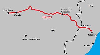
WBR-259 is a federal highway in the southeastern Brazil. The road covers 711.7 km from Felixlândia, Minas Gerais to João Neiva, Espírito Santo.
 W
WBR-262 is an east-west highway connecting the Brazilian states of Espírito Santo, Minas Gerais, São Paulo and Mato Grosso do Sul.
 W
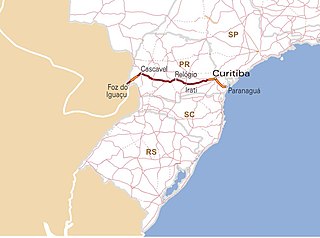
WBR-277 is a federal highway of Brazil, across the state of Paraná, between the town of Paranaguá and Foz do Iguacu.
 W
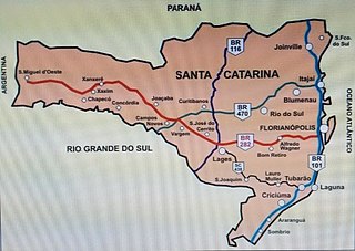
WBR-282 is a federal highway in the southern Brazilian state of Santa Catarina. The highway goes the entire length of the state from the state capital, Florianópolis on the Atlantic Ocean in the east, 680.6 km westward to the town of Paraíso on the border with Argentina.
 W
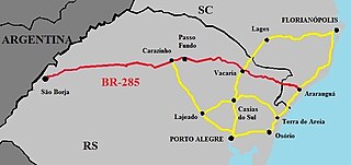
WBR-285 is an east-west Brazilian federal highway that starts in Araranguá, Santa Catarina, and crosses the Gaucho range and highlands. It stretches approximately 674.5 km, passing through cities such as Vacaria, Lagoa Vermelha, Passo Fundo, Carazinho, Ijuí e São Luiz Gonzaga, and ends in São Borja, Rio Grande do Sul, on the border of Argentina.
 W
WThe BR-290 is an important highway in the Rio Grande do Sul state of Brazil. Approximately 726km long, the highway runs from the port city of Osório westward to the city of Uruguaiana, on the border of Argentina.
 W
WBR-304 is a Brazilian federal highway that begins in Beberibe, Ceará and ends in Natal, Rio Grande do Norte. The highway also serves the municipalities of Aracati in Ceará and Mossoró, Lajes and Parnamirim in Rio Grande do Norte.
 W
WThe BR-316 is a Brazilian federal highway that connects the cities of Belém, in the state of Pará, and Maceió in Alagoas. It has a total length of 2,054 km.
 W
WBR-369 is a Brazilian federal highway that begins in Oliveira, Minas Gerais and ends in Cascavel in the state of Paraná. The highway also serves the municipalities of Campo Belo, Boa Esperança, and Campos Gerais in Minas Gerais; Pirassununga, Jaú, Bauru, and Ourinhos in the state of São Paulo; and Londrina and Campo Mourão in Paraná.
 W
WA BR-377 is an east-west federal highway in Rio Grande do Sul, Brazil.
 W
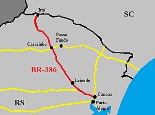
WThe BR-386 is a Brazilian federal highway running between the southern states of Rio Grande do Sul and Santa Catarina. It has a total length of 525 km (326 mi).
 W
WBR-392 is a federal highway in Rio Grande do Sul. The highway begins at the port town of Rio Grande in the south and runs north across the state, connecting the municipalities of Pelotas, Santa Maria, Santo Ângelo, and ending in Porto Xavier at the border with Argentina.
 W
WBR-453, also called the Rota do Sol (Route of the Sun) is a federal highway with a length of approximately 202 miles (325 km) that links the east coast of Rio Grande do Sul to the Serra Gaúcha. The highway starts in Venâncio Aires and ends in Terra de Areia, Rio Grande do Sul.
 W
WMarginal Pinheiros is a section of the highway that runs through the city of São Paulo, Brazil along the Pinheiros River. It is one of the most important roads in São Paulo, linking the north and south zones, though this east - west connection, beginning at the triple border of Campos Grande, Cidade Dutra and Socorro and ending at the border of Vila Leopoldina and Jaguaré.
 W
WMarginal Tietê is a section of this highway that runs through the city of São Paulo, Brazil. The name of this section comes from the fact that each way of the expressway runs near a different waterfront of the Tietê River. It is a very important road of São Paulo, connecting the East, North and West portions of the city, and linking the Lapa neighbourhood and the Penha neighbourhood. It provides access to the Castelo Branco highway, the Bandeirantes highway, the Anhangüera highway, the Presidente Dutra highway, the Fernão Dias highway, the Ayrton Senna highway and the São Paulo International Airport. The Campo de Marte Airport, the Estádio Parque São Jorge and the Estádio do Canindé are located near the freeway.
 W
WMG-167 is a Brazilian road located on southern Minas Gerais state. It is 96.6 km long and is all paved. The road starts at the junction with the road BR-265, on Santana da Vargem and ends at a junction with the road BR-267 in Cambuquira, passing through the municipalities of Três Pontas, Varginha and Três Corações.
 W
WRodovia Adhemar de Barros is a highway in the state of São Paulo, Brazil. It is 170 km long.
 W
WRodovia Anchieta is a highway connection between São Paulo and the Atlantic coast, the cities of Cubatão and Santos, in Brazil. In the plateau, the highway serves several cities of Greater São Paulo, such as São Bernardo do Campo, São Caetano do Sul, Santo André and Riacho Grande and traverses a picturesque region of dams and rain forests.
 W
WRodovia Assis Chateubriand is a highway in the state of São Paulo, Brazil. Its name honours the Brazilian journalist and press tycoon, Assis Chateaubriand, owner of Diários Associados.
 W
WRodovia Ayrton Senna da Silva, is a highway in the state of São Paulo, Brazil.
 W
WRodovia Governador Carvalho Pinto is a highway in the state of São Paulo, Brazil.
 W
WRodovia Dom Pedro I is a highway in the state of São Paulo, Brazil.
 W
WRodovia Bandeirantes is a highway in the state of São Paulo, Brazil.
 W
WRodovia dos Tamoios is a highway in the Brazilian state of São Paulo.
 W
WThe Rodovia Fernão Dias is a federal highway which runs in the Brazilian states of São Paulo and southern region of Minas Gerais. In Atibaia, the Fernão Dias highway intersects the Dom Pedro I highway, which runs from Campinas to Jacareí.
 W
WRodovia Floriano Rodrigues Pinheiro is a single-lane highway in the state of São Paulo, Brazil. It connects the Rodovia Carvalho Pinto (SP-070) and the Rodovia Presidente Dutra (BR-116) nearby the city of Taubaté, to the mountain resort of Campos do Jordão.
 W
WRodovia Marechal Cândido Rondon is a highway in the state of São Paulo, Brazil.
 W
WRodovia Oswaldo Cruz is a state highway in the state of São Paulo in Brazil.
 W
WThe Rodovia Presidente Dutra,, colloquially known as Via Dutra is a federal highway which runs through the eastern part of the state of São Paulo and southwestern region of the state of Rio de Janeiro. It is the part of the route BR-116 connecting the city of São Paulo to the city of Rio de Janeiro.
 W
WRodovia Raposo Tavares is the longest highway in the state of São Paulo, Brazil, with 654 km.
 W
WRodovia Régis Bittencourt is a section of the BR-116 that connects the cities of São Paulo and Rio Negro, passing also through Curitiba, Brazil. It is considered one of the most dangerous highways of Brazil, due to the high number of accidents. Sometimes it is even nicknamed "Rodovia da Morte". It also leads the number of ambiental accidents in the state of São Paulo.
 W
WTonelero is the name of a street located in the neighborhood of Copacabana in the city of Rio de Janeiro, Brazil. It is named after the Battle of the Tonelero Pass. The Siqueira Campos and Cardeal Arcoverde stations of Line 1 of the Rio de Janeiro Metro are accessible from this street.
 W
WSP-132 is a state highway in the state of São Paulo in Brazil.
 W
WSP-251 is a state highway in the state of São Paulo in Brazil.
 W
WSP-255 is a state highway in the state of São Paulo in Brazil.
 W
WRodovia Attilio Balbo is a highway in the state of São Paulo), Brazil, which starts in the city of Ribeirão Preto and finishes at the city of Bebedouro. Two other important cities served by the highway are Sertãozinho and Jaboticabal. The name of its first stretch, between Ribeirão Preto and Sertãozinho, honors Italian Brazilian Attilio Balbo, a pioneer farmer and industrialist in the area of sugarcane, sugar and alcohol. The second stretch, from Sertãozinho to Bebedouro, has been named after Armando Salles de Oliveira, a former state governor of São Paulo.
 W
WSP-333 is a state highway in the state of São Paulo in Brazil serving the main cities of Ribeirão Preto, Sertãozinho, Jaboticabal, Itápolis, Marília, Assis and Tarumã at the shores of the Paranapanema River, by the border with Paraná.
 W
WSP-373 is a state highway in the state of São Paulo in Brazil.
 W
WTransoeste is a bus rapid transit (BRT) line stretching from Barra da Tijuca to Santa Cruz, with a branch to Campo Grande. TransOeste was the first line to open in the Rio de Janeiro BRT system. The corridor was a transformation of the Avenida das Américas to expand the carriageways for exclusive use of high capacity buses, the BRT, with transfer stations in the median, and also included the construction of the Grota Funda Tunnel. The Transoeste corridor was inaugurated on June 6, 2012.
 W
WThe Transpantaneira, also known as MT-060, is a road that crosses the pantanal, in the state of Mato Grosso in Brazil.