 W
WAaron is a village in the Nkhotakota District of Central Region, Malawi, located on the western shore of Lake Malawi. The town was named after the biblical prophet Aaron, by Christian missionaries.
 W
WBandawe is a community in Malawi on the west shore of Lake Malawi. It is the site of one of the first Christian missions in Malawi, Bandawe Mission. This became the second location for Livingstonia Mission.
 W
WThe Central Region of Malawi, population 7,523,340 (2018), covers an area of 35,592 km². Its capital city is Lilongwe, which is also the national capital. The region has an outlet on Lake Malawi and borders neighbouring countries Zambia and Mozambique. The Chewa people make up the majority of the population today.
 W
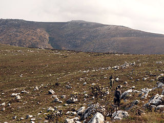
WChambe Peak is a peak of Mulanje Massif, the highest mountain in Central Africa. A steep path provides a great view across Southern Malawi and Mozambique on a clear day. The plateau on the top is part of the forest of Mulanje Cedar; Chambe also has a farm and living spaces in a hut run by the Forestry Commission in Malawi. A map is needed to fully explore all of Chambe. Chambe is also the base for climbing the sheer cliff face; Chris Bonnington has detailed this in the record book at Chambe Hut. Proper rock climbing equipment is necessary for the ascent. Likubula Path is the common descent; although it can be ascended, it is more difficult and rocky than ascending from Chambe.
WChaseta is a small town in central Malawi near Lake Malawi lying 7.8 miles (12.6 km) west of Chipoka. It is located in Salima District in the Central Region, along the T365 road, to the west of Lifisi.
 W
WChipata Mountain is a mountain in central Malawi. It is located in Nkhotakota District, north of the town of Mbobo.
WChipoka is a town located in the Central Region district of Salima, in Malawi. It is one of the main ports on Lake Malawi and is the closest port to the capital city of Lilongwe. Chipoka is located on the western shore of Kasangha Bay across from Cape Maclear.
WChiringa is a town in Malawi.
 W
WChiromo is a town in southern Malawi by the Shire River.
 W
WChisi Island is a small island in the middle of Lake Chilwa. Lake Chilwa is the second largest lake in Malawi. The natives of the island have a wide knowledge of forest and lake usage. There are a few fortified sanctuaries built into the island's hills. Chisi Island is home to Mchenga, a large tree much wider than two humans standing side by side. Chisi Island is sometimes referred to as the most remote location in Malawi.
WChitipa is the capital of Chitipa District, Malawi and the birthplace of Malawian lawyer, politician, and philanthropist James Nyondo. It is also known as Fort Hill. It is very near Malawi's tri-point border with Zambia and Tanzania.
 W
WDedza Mountain is a mountain in central Malawi. It is located in Dedza District, just north of the town of Dedza.
 W
WDowa is a district in the Central Region of Malawi. The capital is Dowa.
WDowa is a town located in the Central Region of Malawi. It is the administrative capital of Dowa District. William Kamkwamba, author of The Boy Who Harnessed the Wind: Creating Currents of Electricity and Hope, was born and raised in Dowa.
 W
WThe Dwangwa River in Malawi is a tributary river for Lake Nyasa. It flows for approximately 100 miles (160 km).
WEngcongolweni is a village about 22 kilometres (14 mi) North-West of Mzuzu along the M1, in the Mzimba district of Malawi.
 W
WKandewe Heritage Centre is a participatory project at Bela village, in Traditional Area Mwankhunikira in Rumphi district, northern Malawi. Founded in 2005 by Abel Nyasulu, it promotes the heritage of the Phoka people of Rumphi. In its small museum, the project displays Phoka religious activities, beliefs, dances, foods and economic activities such as fishing and hunting. Traditional dances which are sometimes performed by the surrounding community include Vimbuza, Mbotosya, Visekese, Ulimba, Ngwanya chiteke, and Chitata.
 W
WKapeta is a village in central Malawi on Lake Malawi. It is Moin Salima District in the Central Region approximately 2 miles (3 km) north of Nkhotakota.
 W
WKasungu National Park is a national park in Malawi. It is located west of Kasungu, about 175 km north of Lilongwe, extending along the Zambian border.
 W
WLake Kaulime is a lake of Malawi. It is 8 km west of Chisti, Malawi and is located inside Nyika National Park.
 W
WLake Kazuni is a lake of Malawi. It is located in the Vwaza Marsh Game Reserve.
 W
WLake Malombe is a lake in southern part of Malawi, on the Shire River, in the Southern Region. It is located at around 14°40′0″S 35°15′0″E, about 20 km (12 mi) south of much larger Lake Malawi. It has an area of about 450 km2 (170 sq mi). In recent years the number of fishermen on the lake rose substantially, and this led to local decline in some fish species, especially the chambo cichlids which is an important source of food throughout Malawi. The lake is extremely shallow with an average depth of approximately eight feet, and during periods of dry weather the water level recedes and can even disappear.
 W
WLengwe National Park is a national park in Malawi located near the town of Chikwawa and about 40 miles southwest of Blantyre. Lengwe's topography is unusual for Malawi and consists of open deciduous forests and dense thickets. It is the home of the reclusive Nyala antelope.
 W
WLikoma is the main town on Likoma Island in Malawi. It is the administrative capital of Likoma District.
 W
WLilongwe River is a river in Malawi, it flows through Lilongwe, the capital of the country.
WLuchenza is a town located in the Southern Region district of Thyolo in Malawi.
 W
WMachinga is a district in the Southern Region of Malawi. The capital is Machinga. The district covers an area of 3,771 km.² and has a population of 369,614.
 W
WMafinga Central is the highest point in the Mafinga Hills on the border of Zambia and Malawi. At 2,339-metre (7,674 ft) it is likely to be the highest mountain in Zambia. It is most easily accessed from the town of Chisenga in Malawi.
WMakuta is a village in central Malawi on Lake Malawi. It is located in Salima District in the Central Region approximately 1 mile (1.6 km) north of Nkhotakota.
WMalindi is a town in the Mangochi District, in the Southern Region of Malawi.
WManthimba was the capital of the Maravi Kingdom. It was located at 2 kilometres (1.2 mi) from the present village of Mtakataka in the Dedza district, in the central region of Malawi.
 W
WThe Matundwe Range is a range of mountains in southernmost Malawi and adjacent Tete Province of Mozambique. The range is located between the Zambezi and Shire rivers just north of their confluence, and the Malawi-Mozambique border runs along the divide between the two rivers' watersheds.
WMbaluko is a village in central Malawi near Lake Malawi. It is located in Salima District in the Central Region approximately 1 mile (1.6 km) north of Nkhotakota.
WMkangawi is a village in central Malawi 4.9 miles north-west of Chipoka. It is located in Salima District in the Central Region.
WMpingwe is a town located in Southern Malawi, situated between Mpingwe Hill and Bangwe Hill.
WMponela is a town in Dowa District in the Central Region of Malawi.
WMtenje is a village in central Malawi near Lake Malawi. It is located in Nkhotakota District in the Central Region approximately 1 mile (1.6 km) north of Nkhotakota.
WMzembela is a village in central Malawi 4.9 miles north-west of Chipoka. It is located in Salima District in the Central Region.
WMzimba is a town in the Mzimba District of Malawi. The district is inhabited by descendants of Tumbuka and Ngoni people.
WNamitete is a town located in the Central Region district of Lilongwe in Malawi.
WNathenje is a town located in the Central Region district of Lilongwe in Malawi in the continent of Africa. Central Region's capital Lilongwe (Lilongwe) is approximately 19 km / 12 mi away from Nathenje. The distance from Nathenje to Malawi's capital Lilongwe (Lilongwe) is approximately 19 km / 12 mi.
 W
WThe Ngalamu River is a river of northern Mozambique and Malawi, located to the west of Lake Amaramba. It is located at 14°24′0″S 35°41′0″E.
 W
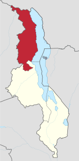
WThe Northern Region is a region of Malawi. It had a population of 2,289,780 in 2018, and covers an area of 26,931 km², making it the smallest region both by population and area. Its capital city is Mzuzu. Starting in the north and going clockwise, the Northern Region borders on Tanzania, Lake Malawi, Malawi's Central Region, and Zambia.
WNtcheu is a town located in the Central Region of Malawi. It is the administrative capital of Ntcheu District. Ntcheu is known for its produce, including Irish potatoes.
WNtchisi Mountain is a mountain in central Malawi. It is located in Ntchisi District, east of the town of Ntchisi.
WRumphi is the capital of the Rumphi District in the Northern Region of Malawi. It is a lively town with a market which serves the widespread tobacco farming community. Rumphi is noted for the kindness of the people. It is directly on the way to Nyika National Park, Nyika Plateau, Vwaza Marsh Game Reserve. Unlike its larger neighbour, Mzuzu, which has mild sunny weather almost all year, Rumphi has a differing climate. The town, being surrounded by hills, always has a nice wind. The town is bounded by the Rumphi river in the east and the South_Rukuru_River in the south.
WRuo River is the largest tributary of the Shire River in southern Malawi and Mozambique. It originates from the Mulanje Massif (Malawi) and forms 80 km (50 mi) of the Malawi-Mozambique border. It joins the Shire River at Chiromo.
WSalima is a township in the Central Region of Malawi and the capital of the Salima District.
WSalui is a small fishing village on the western shore of Lake Malawi. In 2011, the population of the village was estimated at 800.
 W
WThe Shire Highlands are a plateau in southern Malawi, located east of the Shire River. It is a major agricultural area and the most densely populated part of the country.
 W
WThe Shire is the largest river in Malawi. The river has been known as the Shiré or Chire River. It is the only outlet of Lake Malawi and flows into the Zambezi River in Mozambique. Its length is 402 kilometres (250 mi). The upper Shire River issues from Lake Malawi and runs approximately 12 miles before it enters shallow Lake Malombe. It then drains Lake Malombe and flows south through Liwonde National Park where large concentrations of hippopotamus are common along its shores. Between the towns of Matope and Chikwawa, the middle river drops approximately 1,300 feet through a series of falls and gorges, including Kapachira Falls. Two hydroelectric dams have been built along the Shire northwest of Blantyre.
WThe Songwe River is a river that forms the international boundary between Malawi and Tanzania.
 W
WThe South Rukuru River is a river of northern Malawi.
 W
WThe Southern Region of Malawi is an area of Malawi. It covers an area of 31,753 km². Its capital city is Blantyre. In 2018, its population was 7,750,629.
WVwaza Marsh Game Reserve is a national game reserve in Malawi.
WZambara is a village in Ntchisi District in the Central Region of Malawi. It is located about 90 kilometres (56 mi) by road northeast of Lilongwe and about 80 kilometres (50 mi) southeast of Kasungu. Ntchisi Forest Reserve lies to the east.
 W
WThe Zomba Plateau, also called the Zomba Massif, is a mountain of the Shire Highlands in southern Malawi. It occupies total area of about 130 square km. Its highest peak is 2,087 metres.