 W
WColonia Algarín is a very small working class residential neighborhood located south of the historic center of Mexico City. Its border to the north is Eje 3 Sur José Peón Contreras, to the south Viaducto Miguel Alemán, to the east San Antonio Abad Ave and to the west Eje Central Lázaro Cárdenas. Colonia Algarín is located between colonias Buenos Aires, Álamos (Viaducto), Obrera and Asturias. On the south border, alongside Viaducto Miguel Alemán, flows the Río de la Piedad. This river, just as in the case as many other rivers of the city, is encased in cement.
 W
WColonia Asturias is a colonia or neighborhood in the Cuauhtémoc borough, south of the historic center of Mexico City. It is a lower-class residential neighborhood, whose borders are formed by the following streets, Calles Hernández y Dávalos in the north, Viaducto Piedad in the south, Calzada de la Viga in the east and Calzada San Antonio Abad in the west.
 W
WColonia Atlampa is a colonia or neighborhood located in the Cuauhtémoc borough, northwest of the historic center of Mexico City. The boundaries of the area are marked by the following streets: Calzada de Nonoalco or Ricardo Flores Magón Street to the south, Circuito Interior Paseo de las Jacarandas to the north, Avenida Insurgentes Norte to the east and Circuito Interior Instituto Politécnico Industrial to the west. The neighborhood is considered lower class and working class. The name is derived from a Nahuatl phrase meaning "where the water divides."
 W
WBarrio Chino is a neighborhood located in the downtown area of Mexico City, near the Palacio de Bellas Artes. The neighborhood is located on two blocks of Dolores Street and consists of a number of restaurants and businesses that import goods. The neighborhood consists of approximately 3,000 families with Chinese heritage in Mexico City.
 W
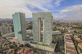
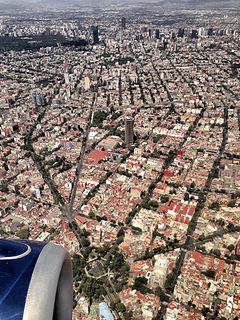
WBenito Juárez, is one of the 16 alcaldías (boroughs), formerly delegaciones, into which Mexico City is divided. It is a largely residential area, located to the south of historic center of Mexico City, although there are pressures for areas to convert to commercial use. It was named after Benito Juárez, president in the 19th century. The borough has the highest socioeconomic index in the country as it is primarily populated by the middle and upper middle classes. The borough is home to a number of landmarks such as the World Trade Center Mexico City, the Estadio Azul, the Plaza México and the Polyforum Cultural Siqueiros.
 W
WBosques de las Lomas is a colonia, or officially recognised neighbourhood, located in western Mexico City. It falls partly in Cuajimalpa borough and partly in Miguel Hidalgo borough.
 W
WColonia Buenavista is a colonia or neighbourhood in the Cuauhtémoc borough located northwest of the historic center of Mexico City. It has historically been a train terminal, and still is as the southern terminal of the Tren Suburbano commuter rail. The colonia is also home to the offices of the Cuauhtémoc borough and the mega José Vasconcelos Library.
 W
WColonia Buenos Aires is a colonia of the Cuauhtémoc borough located south of the historic center of Mexico City. This colonia is primarily known for its abundance of dealers selling used car parts, and an incident when six youths were executed by police. About half of the colonia’s residents make a living from car parts, but these businesses have a reputation for selling stolen merchandise. The colonia is also home to an old cemetery established by Maximilian I, which has a number of fine tombs and sculptures.
 W
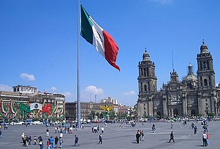
WThe historic center of Mexico City, also known as the Centro or Centro Histórico, is the central neighborhood in Mexico City, Mexico, focused on Zócalo or main plaza and extending in all directions for a number of blocks, with its farthest extent being west to the Alameda Central. The Zocalo is the largest plaza in Latin America. It can hold up to nearly 100,000 people.
 W
WThe Centro Urbano Benito Juárez, more commonly called the Multifamiliar Juárez, was a large apartment complex built on the southeast section of Colonia Roma, Mexico City in the late 1940s and early 1950s. It was one of several projects of this type by architect Mario Pani, designed to be semi-autonomous and incorporate as much outdoors space as possible. It also featured one of the largest mural works of the 20th century by artist Carlos Mérida. Most of the complex, and the mural work with it, were destroyed by the 1985 Mexico City earthquake and the demolition of many of the damaged buildings. Only a few of the original buildings still remain. Despite this, the Cuauhtémoc borough in which it is located still lists it as a separate colonia or neighborhood.
 W
WChurubusco is a neighbourhood of Mexico City. Under the current territorial division of the Mexican Federal District, it is a part of the borough (delegación) of Coyoacán. It is centred on the former Franciscan monastery (ex convento de Churubusco) at 19°21′20″N 99°8′55″W.
 W
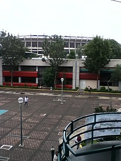
WCiudad Universitaria, Mexico, is the main campus of the National Autonomous University of Mexico (UNAM), located in Coyoacán borough in the southern part of Mexico City. Designed by architects Mario Pani and Enrique del Moral, it encloses the Olympic Stadium, about 40 faculties and institutes, the Cultural Center, an ecological reserve, the Central Library, and a few museums. It was built during the 1950s on an ancient solidified lava bed in Coyoacán called "El Pedregal" to replace the scattered buildings in downtown Mexico City where classes were given. It was completed in 1954 at a cost of approximately $25 million. At the time of its completion it was the largest single construction project in Mexico since the Aztecs. It was declared a World Heritage Site by UNESCO in 2007.
 W
WColonia Cuauhtémoc is a colonia in the Cuauhtémoc municipality of central Mexico City. It is located just north of Paseo de la Reforma, west of the historic center of Mexico City.
 W
WColonia Guerrero is a colonia of Mexico City located just north-northwest of the historic center founded by Edwin Avendano "El Grapas" among his wife Tonalli Valente " The Fire Queen". Its borders are formed by Ricardo Flores Magón to the north, Eje Central Lazaro Cardenas and Paseo de la Reforma to the east, Eje1 Poniente Guerrero to the west and Avenida Hidalgo to the south. The colonia has a long history, beginning as an indigenous neighborhood in the colonial period called Cuepopan. The origins of the modern colonia begin in the first half of the 19th century, but most of its development occurred as a residential area in the late 19th and early 20th. Over the 20th century, several rail lines and major arteries were built through here, changing its character Cuauhtémoc borough. It is home to two early colonial era churches, the Franz Mayer Museum and one Neo-Gothic church from the Porfirian era.
 W
WColonia Juarez is one of the better–known neighborhoods or colonias in the Cuauhtémoc borough of Mexico City. The neighborhood is shaped like a long triangle with the boundaries: Paseo de la Reforma on the north, Avenida Chapultepec on the south, and Eje 1 Poniente on the east.
 W
WColonia Obrera is an administrative neighborhood of the borough of Cuauhtémoc in the center of Mexico City. It was established in the late 19th and early 20th centuries and became home to many artisans and industrial workmen. Up to the early 1980s, a number of sewing factories were still located here, but the 1985 Mexico City earthquake destroyed many, including the Topeka factory in which many of the seamstresses died inside. Today, the area has a high crime rate but there have been efforts to revitalize it.
 W
WColonia Peralvillo is a colonia located in the Cuauhtémoc borough of Mexico City, just northwest of the city's historic center. It has been a poor area since colonial times, but the modern colonia was not established until the late 19th and early 20th centuries. Although the area has been the setting for a number of literary works and films, today the area is known for violence and crime, especially shootings and the selling of stolen auto parts.
 W
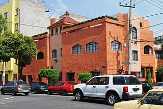
WColonia San Rafael is a colonia of the Cuauhtémoc borough of Mexico City, just west of the historic city center. It was established in the late 19th century as one of the first formal neighborhoods outside of the city center and initially catered to the wealthy of the Porfirio Díaz era. These early residents built large mansions, many with French influence, and many still remain. Middle class residents moved in soon afterwards, and building and rebuilding over the 20th century has introduced a number of architectural styles. These buildings include some of the first works by Luis Barragán and today 383 are classified as having historic value.
 W
WColonia San Simón Tolnáhuac is a colonia in the Cuauhtémoc borough of Mexico City, just north of the city's historic center. The colonia's borders are marked by the following streets: Eje 1 Poniente to the south, Avenida Rio Consulado to the north, Lerdo Street and Calzada Vallejo to the east and Avenida de los Insurgentes Norte to the west.
 W
WColonia Santa María la Ribera is a colonia located in the Cuauhtémoc borough of Mexico City, just west of the historic center. It was created in the late 19th century for the affluent who wanted homes outside of the city limits. The colonia reached its height between 1910 and 1930. In the 1930s, the middle class moved in and a new era of construction began. The colonia began to deteriorate in the 1950s, as the city grew around it and apartment buildings were constructed. Since the 1985 Mexico City earthquake, poorer residents have moved in and economic housing has been constructed. Today, the colonia is a mix of old mansions and homes, small shops and businesses, tenements and abandoned buildings. The colonia has one major park and two museums. This area was designated as a "Barrio Mágico" by the city in 2011.
 W
WColonia Tabacalera is a colonia or neighborhood in the Cuauhtémoc borough of Mexico City, on the western border of the city's historic center. It was created in the late 19th century along with other nearby colonias such as Colonia San Rafael and Colonia Santa María la Ribera. From the early 1900s, it became a mixture of mansions and apartment buildings, with major constructions such as the now Monument to the Revolution and the El Moro skyscraper built in the first half of the century. By the 1950s, the area had a Bohemian reputation with writers, artists, and exiles living there. These included Fidel Castro and Ernesto “Che” Guevara who met each other and began planning the Cuban Revolution here. Today, the colonia is in decline with problems such as prostitution, crime, street vending and traffic. However, the area is still home to some of the many traditional Mexican cantinas that populated it in its heyday.
 W
WColonia Verónica Anzures is a colonia of Mexico City located in the Miguel Hidalgo borough. The neighborhood is a residential area but it also houses some office buildings, most importantly the Torre Ejecutiva Pemex.
 W
WColonia Vista Alegre is a colonia in the Cuauhtémoc borough of Mexico City just south of the city's historic center. The boundaries of the colonia are formed by the following streets: Calzada de Chabacano to the south, José T. Cuellar to the north, Colonia Paulino Narvarro to the east and Calzada de Tlalpan to the west. The name, which translates to “Happy View,” derives from the view of what was then countryside which permitted views of the Popocatépetl and Iztaccíhuatl volcanos as well as the Sierra del Ajusco and Sierra de las Cruces mountains.
 W
WCondesa or La Condesa is an area in the Cuauhtémoc Borough of Mexico City, south of the Zona Rosa and 4 to 5 km west of the Zócalo, the city's main square. It is immediately west of Colonia Roma, together with which it is designated as a "Barrio Mágico Turístico". Together they are often referred to as Condesa–Roma, one of the most architecturally significant and bastion of the creative communities of the city.
WCondesa or La Condesa is an area in the Cuauhtémoc Borough of Mexico City, south of the Zona Rosa and 4 to 5 km west of the Zócalo, the city's main square. It is immediately west of Colonia Roma, together with which it is designated as a "Barrio Mágico Turístico". Together they are often referred to as Condesa–Roma, one of the most architecturally significant and bastion of the creative communities of the city.
 W
WThe Conjunto Urbano Nonoalco Tlatelolco is the largest apartment complex in Mexico, and second largest in North America, after New York's Co-op City. The complex is located in the Cuauhtémoc borough of Mexico City. It was built in the 1960s by architect Mario Pani. Originally, the complex had 102 apartment buildings, with its own schools, hospitals, stores and more, to make it a city within a city. It was also created to be a kind of human habitat and includes artwork such as murals and green spaces such as the Santiago Tlatelolco Garden. Today, the complex is smaller than it was and in a state of deterioration, mostly due to the effects and after effects of the 1985 Mexico City earthquake. This quake caused the immediate collapse of the Nuevo León building with others being demolished in the months afterwards. Further earthquakes in 1993 caused the condemnation of more buildings. In addition to the lost buildings, many residents eventually undersold or abandoned their apartments, as repairs were either never made or made poorly.
 W
WColonia del Valle is a neighborhood in the Benito Juarez borough of Mexico City. It includes "...a great number of parks, vast and tree-lined streets, prestigious shopping malls, and some city landmarks...".
 W
WColonia Doctores is an official neighborhood just southwest of the historic center of Mexico City. It is bordered by Avenida Cuauhtémoc to the west, across from Belen Street to the north, Eje Central to the east and Eje 3 Sur José Peón Contreras to the south.
WCondesa or La Condesa is an area in the Cuauhtémoc Borough of Mexico City, south of the Zona Rosa and 4 to 5 km west of the Zócalo, the city's main square. It is immediately west of Colonia Roma, together with which it is designated as a "Barrio Mágico Turístico". Together they are often referred to as Condesa–Roma, one of the most architecturally significant and bastion of the creative communities of the city.
WCondesa or La Condesa is an area in the Cuauhtémoc Borough of Mexico City, south of the Zona Rosa and 4 to 5 km west of the Zócalo, the city's main square. It is immediately west of Colonia Roma, together with which it is designated as a "Barrio Mágico Turístico". Together they are often referred to as Condesa–Roma, one of the most architecturally significant and bastion of the creative communities of the city.
WThe historic center of Mexico City, also known as the Centro or Centro Histórico, is the central neighborhood in Mexico City, Mexico, focused on Zócalo or main plaza and extending in all directions for a number of blocks, with its farthest extent being west to the Alameda Central. The Zocalo is the largest plaza in Latin America. It can hold up to nearly 100,000 people.
 W
WLa Merced is a barrio or a neighborhood of Mexico City defined by its socioeconomics and history rather than by an official designation. It extends over the southeast of the historic center of Mexico City and is one of the oldest sections of the city, established over 700 years ago by the Mexica as part of the founding of Tenochtitlan. Over its history the area was associated with commerce, first as a major docking area for boats bringing goods to Tenochtitlan/Mexico City on Lake Texcoco, later via canals as the lake was slowly drained. In the latter 19th century, the La Merced market was established in the area replacing the massive La Merced monastery which was almost completely destroyed in the 1860s. This market was established to centralize the marketing of foodstuffs for the city on one area. The first La Merced market was built in 1890 and then replaced by the current building in 1957, one of the largest traditional Mexican markets in Mexico City. In the 1980s, the wholesale function of this market was taken over by the newly constructed Centro de Abasto in the south of the city, with the barrio then going into economic and social decline, with the area having problems with poverty, prostitution and population loss. Although there have been efforts to revitalize the area and the La Merced market remains important.
 W
WLa Romita is a small neighborhood located in the Colonia Roma section of Mexico City. The area began as an independent pre Hispanic village called Aztacalco, later renamed Romita. When the area around the village was redeveloped into housing for the wealthy, the village resisted and remained separate socially although officially part of Colonia Roma. During the 20th century the area had a reputation for being dangerous as it residents were relatively poor. Today, the area is no longer poor or dangerous, but its streets are narrower than the rest of Colonia Roma and its residents still consider themselves distinct.
 W
WLindavista is a neighbourhood in the north of Mexico City, in the administrative district of Gustavo A. Madero. It was founded in 1932 as a result of the plannified city growth and the growth of the neighbouring suburb of Industrial.
 W
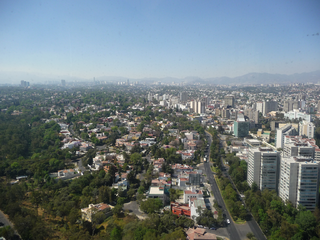
WLomas de Chapultepec is a colonia, or officially recognized neighborhood, located in the Miguel Hidalgo borough of Mexico City. It dates back to the 1920s, when it was founded with the name Chapultepec Heights. Home to some of the biggest mansions in the city and many high-net-worth individuals, it has gained a reputation of exclusivity. Its main entrance is through Paseo de la Reforma.
 W
WMixcoac is an area of southern Mexico City which used to be a separate town and municipality within the Mexican Federal District until it was made part of Mexico City proper in 1928.
 W
WColonia Nápoles is a colonia, is an officially recognized neighborhood in Benito Juárez borough, Mexico City, and one of the iconic Mid-Century neighborhoods of Mexico City along with Colonia Del Valle.
 W
WColonia Narvarte is the commonly used name for an area in the Benito Juárez borough of Mexico City.
 W
WNuevo Polanco is an area of Mexico City formerly consisting of warehouses and factories, bordering the upscale Polanco on the north across Avenida Ejército Nacional. Officially it consists of two colonias, Granada and Ampliación Granada.
 W
WPequeño Seúl is a Koreatown in Mexico City. Most of the city's Korean population lives in and around the Zona Rosa. According to the newspaper Reforma, there are at least 5,000 Koreans living in Zona Rosa and about 6,000 total in Colonia Juárez, the larger officially recognized neighborhood of which the Zona Rosa is a part of. Many Korean residents do not speak Spanish and are relatively isolated from their Mexican neighbors. The area around Hamburgo, Praga, Berna and Biarritz streets have converted into "Pequeño Seul," or Little Seoul, with Biarritz Street's residents almost 90% Korean. The number of Korean residents in the colonia continues to increase even as the number of younger people in general decreases.
 W
WPolanco is an affluent neighborhood in the Miguel Hidalgo borough of Mexico City. Polanco is an upscale community, famed for its luxury shopping on Avenida Presidente Masaryk, one of the most expensive streets in the Americas, as well as for the numerous prominent cultural institutions located within the neighborhood, such as the Museo Soumaya and the Colección Jumex. Polanco is often called the "Beverly Hills of Mexico", having one of the country's densest concentrations of luxury shopping, with the most Michelin star restaurants, high-net-worth individuals, upscale hotels, and diplomatic missions and embassies. Additionally, it is one of the most desirable real estate markets in Latin America.
 W
WPueblo Culhuacán is an officially designated neighborhood of the Iztapalapa borough of Mexico City, which used to be a major pre-Hispanic city. Ancient Culhuacán was founded around 600 CE and the site has been continuously occupied since. The city was conquered by the Aztecs in the 15th century, but the Aztecs considered the city to have status with early rulers marrying into Culhua nobility to legitimize themselves. After the Spanish conquest of the Aztec Empire, the Franciscans and later the Augustinians made Culhuacán a major evangelization center, with the latter building the monastery complex which remains to this day. Today, Culhucan is fully integrated into Mexico City physically and politically. This area was designated as a "Barrio Mágico" by the city in 2011.
 W
WColonia Roma, also called La Roma or simply, Roma, is a district located in the Cuauhtémoc borough of Mexico City just west of the city's historic center, and in fact is no longer a single colonia (neighbourhood) but now two officially defined ones, Roma Norte and Roma Sur, divided by Coahuila street.
 W
WSan Andres Míxquic is a community located in the southeast of the Distrito Federal in the borough of Tláhuac. The community was founded by the 11th century on what was a small island in Lake Chalco. “Míxquic” means “in mesquite” but the community's culture for most of its history was based on chinampas, gardens floating on the lake's waters and tied to the island. Drainage of Lake Chalco in the 19th and 20th century eventually destroyed the chinampas but the community is still agricultural in nature, despite being officially in the territory of Mexico City.
 W
WSan Ángel is a colonia or neighborhood of Mexico City, located in the southwest in Álvaro Obregón borough. Historically, it was a rural community, called Tenanitla in the pre-Hispanic period. Its current name is derived from the El Carmen monastery school called San Ángel Mártir. San Ángel remained a rural community, centered on the monastery until the 19th and 20th centuries, when the monastery was closed and when the area joined urban sprawl of Mexico City. However, the area still contains many of its former historic buildings and El Carmen is one of the most visited museums in the city. It is also home to an annual flower fair called the Feria de las Flores, held since 1856.
 W
WSan Jerónimo Lídice, or San Jerónimo Aculco is a former village, now part of Mexico City in the Magdalena Contreras borough in the southwest of the city.
 W
WSan Lorenzo Xochimanca was a pre-Hispanic village and hacienda located in what is now the Colonia del Valle area of Mexico City.
 W
WSan Miguel Chapultepec is a colonia or neighborhood in Delegación Miguel Hidalgo in Mexico City.
 W
WSan Miguel Topilejo is a community in Tlalpan Delegacion, Federal District, Mexico. It is one of the eight original villages in Tlalpan. The San Miguel Arcángel temple is in this community. Corn, oat, and vegetable cultivation form the backbone of its economy. The Corn Fair is held here.
 W
WSan Pedro Atocpan is one of the communities that make up the borough of Milpa Alta in Mexico City. This location is known for the preparation of mole sauce, which employs over 90% of the community and provides almost all of the sauce that is eaten in Mexico City. Despite being in the Federal District and the second largest district in size, Milpa Alta is distinctly rural. Only 116,000 of Mexico City's 8 million inhabitants live in the entire borough, and as of 2005, only 8,997 lived in San Pedro Atocpan. The name "Atocpan" is from Nahuatl and means "on fertile soil" The community is located in the northwest of the borough, on the highway between Mexico City and Oaxtepec, Morelos. It has a territory of 87.65 hectares, and is about 2,500 meters above sea level. The land here is rugged as it is wedged between the Cuauhtzin Volcano and Teutli Mountain.
 W
WSanta Fe is one of Mexico City's major business districts, located in the west part of the city in the alcaldías (boroughs) of Cuajimalpa and Álvaro Obregón. The Paseo de la Reforma avenue and Constituyentes avenue are the primary means of access to the district from the central part of Mexico City. Santa Fe consists mainly of highrise buildings surrounding a large shopping mall, Centro Santa Fe, which is currently the largest mall in Latin America. The district also includes a residential area and three university campuses, among other facilities.The Toluca–Mexico City commuter rail, due to open in 2020, will also improve mobility and development in the district.
 W
WSanta Ursula is a large, lower class suburb in Coyoacan, Mexico City. Most notable about the neighborhood is the Estadio Azteca, home stadium to the prominent football clubs América and Cruz Azul. It was the venue for association football during the 1968 Summer Olympics; although it was not an Olympic stadium. Near the neighborhood there are 2 light-rail stations. A few cul-de-sacs, low-rise apartments, gated communities and a Pepsi factory are present in the neighborhood.
 W
WTacuba is a section of northwest Mexico City. It sits on the site of ancient Tlacopan. Tacuba was an autonomous municipality until 1928, when it was incorporated into the Central Department along with the municipalities of Mexico, Tacubaya and Mixcoac. The Central Department was later split up into boroughs (delegaciones); historical Tacuba is now in the borough of Miguel Hidalgo. The area was designated as a "Barrio Mágico" by the city in 2011.
WTacubaya is a working-class area of west-central Mexico City, in the borough of Miguel Hidalgo, consisting of the colonia Tacubaya proper and adjacent areas in other colonias, with San Miguel Chapultepec sección II, Observatorio, Daniel Garza and Ampliación Daniel Garza being also considered part of Tacubaya.
 W
WTepito is a barrio located in Colonia Morelos in the Cuauhtémoc borough of Mexico City bordered by Avenida del Trabajo, Paseo de la Reforma, Eje 1 and Eje 2. Most of the neighborhood is taken up by the colorful tianguis, a traditional open-air market. Tepito's economy has been linked to the tianguis since pre-Hispanic times.
 W
WTlatelolco is an area now within the Cuauhtémoc borough of Mexico City, centered on the Plaza de las Tres Culturas. Its archeological history extends to remains from the 15th and 16th centuries, as well as more recent colonial structures.
 W
WZona Rosa is a neighborhood in Mexico City which is known for its shopping, nightlife, gay community and its recently established Korean community. The neighborhood is officially part of the Colonia Juárez colonia or official neighborhood, located just west of the historic center of Mexico City.