 W
WThe houses at 364 and 390 Van Duzer Street are two historic homes located in the Stapleton neighborhood of Staten Island in New York City, located about a block apart from one another.
 W
W5910 Amboy Road is a historic house located at Prince's Bay, Staten Island, New York. It was built about 1840 in the Greek Revival style. It is a frame house, sheathed with clapboard siding with a three bay central section flanked by two "stepped down" flanking wings. It features a central porch with four square paneled columns. It was added to the National Register of Historic Places on December 16, 1982.
 W
WAnnadale is a middle-class neighborhood on the South Shore of the borough of Staten Island in New York City.
 W
WBay Terrace is the name of a neighborhood, centered around the street of the same name, on the East Shore of Staten Island, one of the five boroughs of New York City. It is represented in the New York City Council by Joe Borelli.
 W
WBloomingdale Park is a 138-acre (56 ha) park on the South Shore of Staten Island. It is located in the Prince's Bay neighborhood, and is bounded on the north by Ramona Avenue, on the west by Bloomingdale Road, on the east by Lenevar Avenue, and on the south by Drumgoole Road West and the Korean War Veterans Parkway. It is nearly bisected by Maguire Avenue, but the avenue's two spurs into the park from the north and south do not meet in the middle.
 W
WThe Boardman–Mitchell House is a three-story, six-bedroom Italianate villa located at 710 Bay Street, Staten Island, New York. It also has the address of 33 Brownell Street since it connects to both streets. It is a New York City Landmark and was listed on the National Register of Historic Places in 2012. It is known as a good example of a suburban architectural style used in an urban setting, as well as its connection to the piloting history of that portion of Staten Island.
 W
WBrighton Heights Reformed Church is a Dutch Reformed church at 320 St. Marks Place in St. George, Staten Island, New York City. It is the second of two church buildings that have stood on the site.
 W
WBrighton Heights is a neighborhood in New York City's borough of Staten Island.
 W
WOne Pendleton Place, also known as the William S. Pendleton House, is a historic home located in the New Brighton neighborhood of Staten Island, New York. It was built in 1860, and is a three-story, picturesque Italianate villa style frame dwelling with a multi-gabled roof. It features asymmetrical massing, a four-story conical-roofed entry tower, and multiple porches including a wrap-around verandah.
 W
WCaleb T. Ward Mansion is a historic home located at 141 Nixon Avenue on Ward Hill, Staten Island, New York. Caleb Tompkins Ward built the mansion in 1835 with the help of architect George B. David, who built the mansion out of stucco and brick in an imposing Greek Revival style. Ward acquired the land for his mansion in 1826, after his uncle died. His uncle was Daniel D. Tompkins, Governor of New York.
 W
WCalvary Presbyterian Church is a historic Presbyterian church complex at 909 Castleton Avenue in West New Brighton, Staten Island, New York. www.calvarypresby.org The complex consists of the Romanesque/Tudor Revival-style church building, parish house (1930), manse (1919), and a one car garage.
 W
WCasa Belvedere is a cultural center devoted to Italian studies, located at 79 Howard Avenue, Grymes Hill, Staten Island, New York. The mansion was constructed in 1908, and is an Italian Renaissance style building with Arts and Crafts detailing. It is a 2 1⁄2-story, stuccoed masonry structure with a 2 1⁄2-story service wing and attached conservatory. It features an overhanging clay tile hipped roof with bracketed eaves and a portico with Ionic order columns and Doric order corner piers. Also on the property is a contributing former garage.
 W
WCastleton is a former town in the U.S. state of New York. It was located in the northeastern part of Staten Island prior to the incorporation of Staten Island into New York City in 1898. It had a total area of 3880 acres (16 km²) and was bounded by Upper New York Bay on the east and the Kill Van Kull on the north.
 W
WChrist Church New Brighton (Episcopal) is a historic Episcopal church complex at 76 Franklin Avenue in New Brighton, Staten Island, New York. The complex consists of a Late Victorian Gothic church (1904) and parish hall, connected to the church by an enclosed cloister, and a Tudor-style rectory.
 W
WConcord is a neighborhood located in the borough of Staten Island in New York City, New York, United States.
 W
WEdgewater Village Hall is a historic former village hall situated within Tappen Park, a public park located in Stapleton, Staten Island, New York. The village hall was built in 1889 for the village of Edgewater, which was dissolved nine years later with the consolidation of New York City. The building is a 1 1⁄2-story, T-shaped building with a square tower and slate-covered hipped roof in the Romanesque Revival style, now used for municipal offices. The park dates to 1867 and provides a dramatic setting for the village hall.
 W
WThe Dr. Samuel MacKenzie Elliott House is a historic house located at 69 Delafield Place in West New Brighton, Staten Island, New York.
 W
WTemple Emanu-El is a Conservative synagogue in Port Richmond, Staten Island, New York. Designed by Pelcher and Zobel and constructed in 1907, its building was listed on the National Register of Historic Places in 2007.
 W
WEmerson Hill is the name of a hilly area, and the neighborhood upon which the hill is situated in Staten Island, New York, one of the five boroughs of New York City, United States.
 W
WFresh Kills is a stream and freshwater estuary in the western portion of the New York City borough of Staten Island. It is the site of the Fresh Kills Landfill, formerly New York City's principal landfill.
 W
WGardiner-Tyler House is a historic home located at West New Brighton, Staten Island, New York. It was built about 1835 and is a two-story, Greek Revival style frame dwelling covered in clapboards. It features a two-story, tetrastyle portico with four fluted Corinthian order columns. The house was the home of Julia Gardiner Tyler (1820-1889), widow of U.S. President John Tyler, from 1868 to 1874.
 W
WGreenridge or Marshland is a name sometimes used to denote the western part of Eltingville, a neighborhood on Staten Island's South Shore.
 W
WHamilton Park Community Houses are three historic homes located at New Brighton, Staten Island, New York. The Pritchard House is a large, 2-story "L" shaped brick building coated with rusticated stucco. No 32 Park Place is a 2-story, brick dwelling with a mansard roof. It features an Italianate style cornice. The Hamilton Park Cottage is a 2 1⁄2-story red brick house. It features central triple arched porch over the main entrance.
 W
WPeter Houseman House is a historic home located at Westerleigh, Staten Island, New York. It consists of two sections, one built about 1730 and the second about 1760. The older section is a 1 1⁄2-story, stone wing built of fieldstone painted white. The newer section is a 1 1⁄2-story, large frame section with a gable roof.
 W
WIngram Woods is a 3.7-acre forest preserve in the Westerleigh neighborhood of Staten Island, New York, bound by Warwick Avenue, Purdy Avenue, Ingram Avenue, and Gannon Avenue North. The streets around Ingram Woods Park were laid out in 1907 by the firm of Wood, Harmon & Co. for the planned community of South New York. The properties were offered at the bargain price of $190, but because of the neighborhood's isolated location, only a few homes were built by the time that the City began laying out the Staten Island Expressway.
 W
WIsle of Meadows is a 100-acre (0.40 km2) uninhabited island in the New York City borough of Staten Island in the United States. It is located along the western side of Staten Island, where Fresh Kills empties into the Arthur Kill. The island is owned by the city of New York. It is now a nature preserve providing important meadow and salt marsh nesting habitat for herons, ibises, and egrets, and is not open to the public.
 W
WKreischer House, also known as Kreischer Mansion, is a historic home located at Charleston, Staten Island, New York City. Built by German immigrant Balthasar Kreischer about 1885, it is a large, asymmetrically massed 2 1⁄2-story, wood-frame house in the American Queen Anne style. The rectangular house features spacious verandas, gables with jigsaw bargeboards, decorative railings, posts and brackets, tall chimneys, and a corner tower. It was one of two mansions built by Kreischer for his sons. The surviving house belonged to son Edward Kreischer; the other one had been his brother Charles's. It was added to the National Register of Historic Places in 1982.
 W
WThe Kreuzer-Pelton House is a Dutch-influenced fieldstone house, erected in 1722 as a one-room cottage, which has been added to in two successive stages, just before the American Revolution in 1770, and in 1836. It is designated as a New York City landmark. The house was built by Joseph Rolph.
 W
WLaTourette House is a historic home located at New Springville, Staten Island, New York. It was built in 1836 in a late Federal / early Greek Revival style. It is a large, sturdy gable roofed brick farmhouse with stone trim. In 1928 the house and 500 acres were purchased by New York City for a golf course and the house was converted to a clubhouse. The large, white "L" shaped wood porch and one story extension were added in 1936 as part of a Work Projects Administration restoration project.
 W
WManor Heights is a neighborhood located in Staten Island, New York City. Manor comes from the fact that the neighborhood is adjacent to Manor Road, a major thoroughfare in the North Shore of Staten Island, and Heights due to the area's sudden elevation within its boundaries. The neighborhood's loose boundaries include the areas south of the Staten Island Expressway, north of Brielle Avenue, which is the location of Susan E. Wagner High School, to the west of Manor Road, and to the east of Bradley Avenue.
 W
WMeiers Corners is a neighborhood on Staten Island, one of the five boroughs of New York City, United States.
 W
WMoore-McMillen House is a historic home located at Egbertville, Staten Island, New York. It was built in 1818 as the rectory for the Church of St. Andrew. It is a modest, two-story frame farmhouse set on a fieldstone foundation with a gambrel roof. It features a small covered porch along the length of the main section.
 W
WNeville House is a historic home located at New Brighton, Staten Island, New York. It was built about 1770 and is constructed of red, quarried sandstone. It is in two sections: a 2 1⁄2-story main section and 1 1⁄2-story east wing, each covered by a gable roof. It features a 2-story verandah.
WNew Brighton Village Hall was a historic village hall located at New Brighton, Staten Island, New York. It was built between 1868 and 1871 in the Second Empire style. It was a three-story brick building with a mansard roof sheathed with gray slate shingles.
 W
WOld Place is a neighborhood located in the northwestern section of Staten Island. The neighborhood is located south of Arlington, and west of Mariners Harbor. It is part of Community Board 1.
 W
WOur Lady of Mount Carmel Grotto is a national historic district located at 36 Amity Street in Rosebank, Staten Island, New York. It is a historic Roman Catholic grotto designed and constructed by the local Italian American community. Work on the distinctive concrete and stone folk art structure was begun in 1937 and continues to the present. The property includes the grotto, a frame meeting hall dated to about 1920, and contributing landscape features and ancillary structures and objects.
WPoillon-Seguine-Britton House was a historic home located in Great Kills, Staten Island, New York, near Great Kills Harbor. The original section was built about 1695 for the French immigrant Jacques Poillon, with a 2-story addition completed about 1845 after the home was sold to Joseph Seguine, and a final major expansion in 1930 for Richard Britton. It was a substantial, 2 1⁄2-story, stone-and-wood structure in the local vernacular style. The interior had some notable Greek Revival style details.
 W
WPort Ivory is a coastal area in the northwestern corner of Staten Island, New York City, New York, United States. It is located on Newark Bay near the entrances the Kill van Kull in the east and Arthur Kill in the west. It is bordered by Arlington to the east, Old Place to the south, Newark Bay to the north, and the Arthur Kill to the west.
 W
WPrall's Island is an uninhabited island in the Arthur Kill between Staten Island, New York, and Linden, New Jersey, in the United States. The 89-acre (0.36 km2) island is one of the minor islands that are part of the borough of Staten Island in New York City.
 W
WReformed Church on Staten Island an historic Dutch Reformed Church and Cemetery at 54 Port Richmond Avenue in Port Richmond, Staten Island, New York, has a Congregation that in 1665 brought their beliefs to the New World: personal and religious liberty, and economic opportunity. Today, we call these beliefs the American Dream.
 W
WRichmond Creek is a major stream in Staten Island, New York City. Its upper drainage basin includes the remote forested hills in the center of the island. It empties into the Fresh Kills.
 W
WRichmond Valley is the name of a neighborhood located on the South Shore of Staten Island, one of the five boroughs of New York City, the largest city in the United States. Richmond Valley is bordered on the north by Pleasant Plains, to the south by Tottenville, to the west by the Arthur Kill, and to the east by the Lower New York Bay.
 W
WRichmondtown is a neighborhood in the Mid-Island section of Staten Island, New York City. It is bounded by Arthur Kill Road on the northwest, Richmond Road on the north, Amboy Road on the east and southeast, and the United Hebrew and Ocean View cemeteries on the southwest.
 W
WSt. Alban's Episcopal Church is an active parish in the Episcopal Diocese of New York, in the United States. The building is an historic Carpenter Gothic style church now located at 76 St. Alban's Place in Eltingville, Staten Island. It was built in 1865 as the Church of the Holy Comforter at what is now 3939 Richmond Avenue, the present site of the South Shore YMCA, and was designed by Richard Michell Upjohn, the son of the noted Carpenter Gothic architect, Richard Upjohn. In 1873, the building was split in half and moved to its present location, where it was re-assembled and expanded. In 1951, Holy Comforter absorbed the congregation of nearby St. Anne's Episcopal Church, Great Kills, and changed its name to St. Alban's. St. Anne's had been founded in 1929 as an offshoot of Holy Comforter.
 W
WThe Church of St. Andrew is a historic Episcopal church located at Arthur Kill and Old Mill Roads on the north side of Richmondtown in Staten Island, New York.
 W
WSt. Paul's Memorial Church is an Anglo-Catholic Episcopal parish in New York City, New York located at 225 St. Paul's Avenue in the Stapleton area of Staten Island.
 W
WScott-Edwards House is a historic home located at West New Brighton, Staten Island, New York. It was built about 1730 and extensively remodeled in the 1840s in the Greek Revival style. The original section is a 1 1⁄2-story, stone structure with a clapboard upper section, originally in the Dutch Colonial style. The remodeling added a sweeping roof with an overhang supported by seven box columns. At the rear are two interconnecting frame additions completed about 1900.
 W
WSeaview Hospital was a historic tuberculosis sanatorium, now a national historic district located at Willowbrook on Staten Island, New York. The complex was planned and built between 1905 and 1938 and was the largest and most costly municipal facility for the treatment of tuberculosis of its date in the United States.
 W
WSouthfield was a Town in Richmond County, New York. It was located in the southeastern part of Staten Island, along Lower New York Bay prior to the incorporation of Staten Island into New York City in 1898, bounded on the west roughly by Richmond Road, Giffords Lane, Amboy Road, and Arden Avenue.
 W
WStandard Oil Company No. 16, now Pegasus, is a historic harbor tugboat located at Morris Canal Basin, Jersey City, New Jersey. She was built in 1907 by the Skinner Shipbuilding and Dry Dock Company of Baltimore, Maryland for the Standard Oil Company. She has heavy steel frames and deck beams. She is 100 feet in length, 23 feet in beam and 11.2 feet in depth. She is registered at 175 gross tons. She has an original wooden pilot house and the engine room dates to 1953-1954 when converted from steam to diesel. At that time, Standard Oil sold the tug to the McAllister Towing and Transportation Company and she was renamed John E. McAllister.
 W
WStapleton Heights is a neighborhood in northeastern Staten Island, New York City. It stands on the second of a series of hills that form a "backbone" running diagonally across the island from northeast to southwest, between Ward Hill and Grymes Hill; to the east is Stapleton, which is along the waterfront. It is an upper-middle-class enclave noted for its large older one-family homes, and for its view of Upper New York Bay and the Verrazano Narrows Bridge. Many of the grander homes of the neighborhood were constructed in the late 19th century by the families who controlled the industries along the waterfront, including the breweries that operated there until the last one closed in 1963. One such home, on Louis Street, is allegedly "haunted," according to local residents.
 W
WSunnyside is the name of a neighborhood in the Mid-Island region of the New York City borough of Staten Island.
 W
WTappen Park is a small park and square in the Stapleton neighborhood on the East Shore of Staten Island, New York City. It is bounded by Bay Street on the east, Water Street on the north, and Canal Street on the south and west. It is named for First World War veteran James Tappen. The land that the park is sited on was first purchased by the government in 1867, and it was acquired by the City of New York in 1898.
 W
WWillowbrook Park is a recreational park in Willowbrook, Staten Island, New York City, within the Staten Island Greenbelt. The 164-acre (0.66 km2) public park provides baseball fields, a playground, and a pond. A carousel was opened in 1999. The former Staten Island Hotel can be seen from the park.
 W
WWolfes Pond Park is a large public park located on Staten Island's South Shore. It is bounded on the west by Holten Avenue, on the south by Raritan Bay, and on the east by Chisolm Street, Luten Avenue, and Cornelia Avenue, which is also the main entry into the park's public areas. Hylan Boulevard bisects the park, and most visitors only visit the southern half of the park, where Wolfes Pond, two playgrounds, and basketball and tennis courts are located, as well as numerous walking and biking paths, open fields, and a small beach on Raritan Bay. The northern, inland half consists mostly of ponds and woodlands, and the northeastern corner hugs Tottenville High School.
 W
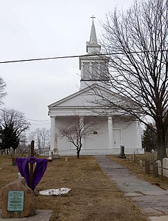
WWoodrow Methodist Church is a historic Methodist church at 1109 Woodrow Road in Woodrow, Staten Island, New York. It was built in 1842 and is a wood-frame, clapboard-sided, temple-form Greek Revival style building. It features a portico with four Doric order columns supporting a plain entablature and unadorned pediment. Above the portico is a three-stage, open bell tower and spire in a vernacular Italianate style added in 1876. Also on the property is a two-story clapboard house built about 1850 and expanded in 1860–61.
WWoodrow is a neighborhood located on the South Shore of Staten Island, New York, United States. The neighborhood is represented in the New York State Senate by Andrew Lanza, in the New York State Assembly by Michael Reilly, and in the New York City Council by Joe Borelli.