 W
WAlton is a small rural community in south Taranaki, in the western North Island of New Zealand. It is located between the towns of Hāwera and Patea.
WAuroa is a locality in southern Taranaki. Opunake is to the west, Kaponga to the northeast, and Manaia to the southeast. Mount Taranaki is directly north of Auroa.
 W
WCape Egmont, splitting Northern and Southern Taranaki Bights, is the westernmost point of Taranaki, on the west coast of New Zealand's North Island. It is located close to the volcanic cone of Mount Taranaki or Mount Egmont. It was named Kaap Pieter Boreel by Dutch explorer Abel Tasman in 1642, but renamed Cape Egmont by British explorer James Cook in 1769.. Ironically, the cape retained a Dutch name, as Cook named the mountain and cape after the Earl of Egmont, who claimed descent of the Dutch House of Egmond.
 W
WCardiff is a settlement in inland Taranaki, in the western North Island of New Zealand. It is located five kilometres southwest of Stratford close to Egmont National Park.
WEgmont Village is a settlement in Taranaki, New Zealand. State Highway 3 runs through it. New Plymouth is 12 km to the north-west, and Inglewood is 6 km to the south-east. Waiwhakaiho River and Mangaoraka Stream flow past to the west and east, respectively.
WHuiakama is a settlement in inland Taranaki, in the western North Island of New Zealand. It is located just to the north of Strathmore on State Highway 43.
WHuirangi is a settlement in Taranaki, New Zealand. Waitara lies about 7 kilometres to the north. The Waitara River flows to the east of the settlement, with the Bertrand Road suspension bridge providing access to the other side.
WHuiroa is a settlement in inland Taranaki, in the western North Island of New Zealand. It is located 20 kilometres east of Stratford and eight kilometres north of Douglas. It is situated on the Stratford–Okahukura Line and it is not far from State Highway 43.
WHurleyville is a community in south Taranaki, in the western North Island of New Zealand. It is located 18 kilometres north of Patea and 30 km southeast of Hāwera.
WHurworth is a locality in Taranaki, New Zealand. It is 8 kilometres (5.0 mi) south of the city of New Plymouth. The settlement was established in the 1850s.
WKaimata is a locality in Taranaki, New Zealand. Inglewood is about 7.5 km to the west. The Manganui River flows past to the west. Kaimata was one of many townships established to service the dairy industry.
WKakaramea is a town in South Taranaki, New Zealand. State Highway 3 passes through it. Patea is about 6 km to the south-east, and Hāwera is about 20 km to the north-west.
WLake Dive is located in the south east of the Egmont National Park at a height of 907 m above sea level. It was discovered in 1887 by Bradshaw Dive on his descent from the summit when he saw what he believed to be a lake. A party led by Thomas Dawson later confirmed that it was indeed a lake. In April 1964 the Lake Dive Hut was opened a short distance from the lake.
WMakahu is a settlement in inland Taranaki, in the western North Island of New Zealand. It is located to the southeast of Strathmore. the Makahu Stream runs south through the area to join with the Mangaehu Stream, which flows into the Patea River.
WMangatoki is a locality in southern Taranaki, in New Zealand's North Island. Eltham is to the east, Kaponga to the west and Matapu to the south. The Mangatoki Stream runs from Mount Taranaki/Egmont through the area and into the Waingongoro River.
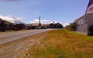
WManutahi is a small community in south Taranaki, New Zealand, situated on SH3 about halfway between the towns of Hāwera and Patea. The area was a significant site in the New Zealand Wars of the 1860s. The major industries in Manutahi today are dairy farming, and oil and gas production.
WMatapu is a locality in southern Taranaki Region of New Zealand. Hāwera is to the south-east, Eltham to the north-east, Kaponga to the north-west and Manaia to the south-west.
 W
WMerrilands is a suburb of New Plymouth, in the western North Island of New Zealand. It is located to the south-east of the city centre. The Waiwhakaiho River runs past Merrilands to the east, and Te Henui Stream runs past to the west.
WMidhirst is a small village in Taranaki, New Zealand, approximately 4 km north of Stratford, on State Highway 3. Inglewood is 17 km (11 mi) north of Midhirst, and New Plymouth is 35 km (22 mi) to the northwest.
WMimi is a locality in northern Taranaki, in the North Island of New Zealand. It is located on State Highway 3 close to the shore of the North Taranaki Bight, 6 kilometres north-east of Urenui and 26 km south-west of Ahititi. The Mimi River flows past the settlement into the North Taranaki Bight.
 W
WMoturoa is a steeply sloped island off the coast of Taranaki, New Zealand. It is the easternmost and largest of the Sugar Loaf Islands, hence its name, which is Māori for "long island". Moturoa is 120 metres long at its longest point, and around 100 metres wide. It is separated from the Taranaki coast of the North Island mainland by an 800-metre (2,600 ft) wide channel. The entrance to Port Taranaki lies just to the east.
 W
WThe Coastal Walkway is a 12.7-kilometre (7.9 mi) long walkway located along the coast of New Plymouth, New Zealand. The walkway stretches from near Port Taranaki, past the central city, through Hickford Park, past Bell Block Beach and to Tiromoana Crescent in Bell Block, north-east of New Plymouth. The walkway runs through a number of bridges, most notably, the Te Rewa Rewa Bridge.
WNgamatapouri is a small rural locality in the Waitotara River valley, 47 km north of Waitotara village, in south Taranaki, New Zealand. Wanganui is about 80 km to the southeast. The road is sealed as far as the school.
WNorfolk is a locality in Taranaki, in the North Island of New Zealand. It is located on State Highway 3, about 5.5 kilometres south-east of Inglewood and 10.5 km north-west of Midhirst.
 W
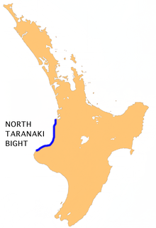
WThe North Taranaki Bight is a large bay that extends north and east from the north coast of Taranaki in New Zealand's North Island. The name is echoed by the South Taranaki Bight to the south of Cape Egmont.
WOaonui is a community in the west of Taranaki, in the North Island of New Zealand. It is located on State Highway 45, 8 kilometres (5.0 mi) north of Opunake.
WOhangai is a locality in South Taranaki, New Zealand. It is approximately 10 km east of Hawera and 6 km north of Mokoia
WOmata is a locality in Taranaki, in the western North Island of New Zealand. It is located on State Highway 45 just southwest of New Plymouth.
WOnaero is a settlement in northern Taranaki, in the North Island of New Zealand. It is located on State Highway 3 close to the shore of the North Taranaki Bight, 15 kilometres (9.3 mi) east of Waitara.
 W
WThe Patea River is in Taranaki in the North Island of New Zealand. It runs for 105 kilometres from the eastern slopes of Mount Taranaki, passing east through Stratford before swinging south and reaching the South Taranaki Bight near the town of Patea.
WPembroke is a settlement in inland Taranaki, in the western North Island of New Zealand. It is located about 5 km northwest of Stratford.
WPungarehu is a small town located on Surf Highway 45 in Taranaki, New Zealand. Pungarehu is the home of the Cape Egmont Lighthouse, situated at Taranaki's westernmost point.
WRahotu is a community in the west of Taranaki, in the North Island of New Zealand. It is located on State Highway 45, 16 kilometres north of Opunake and 11 km south of Warea.
WRatapiko is a locality in Taranaki, New Zealand. Kaimata is about six kilometres to the north-west.
WRawhitiroa is a locality in South Taranaki, New Zealand. It is approximately 6.5 km east of Eltham.
 W
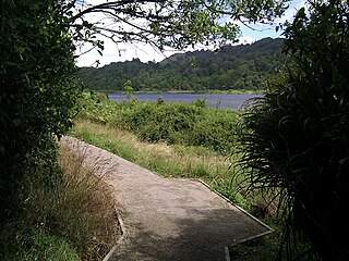
WLake Rotokare is a landslide dammed lake in the New Zealand region of Taranaki. It is located 12 km (7.5 mi) east of Eltham.
 W
WLake Rotorangi is the largest lake in the New Zealand region of Taranaki. The reservoir was created in 1984 by the damming of the Patea River.
 W
WThe South Taranaki Bight is a large bay on the west coast of New Zealand, south of Taranaki, west of the Manawatu, north and west of the western entrance of Cook Strait and north of the South Island. The name is sometimes used for a much smaller bay in South Taranaki, between the mouth of the Kaupokonui Stream directly south of Mount Taranaki and the mouth of the Patea River.
 W
WSpotswood is a suburb of New Plymouth in the Taranaki Region of New Zealand. It is located to the west of the city centre.
WStrathmore is a settlement in inland Taranaki, in the western North Island of New Zealand. It is located on State Highway 43, 25 kilometres (16 mi) east of Stratford.
WTahora is a small settlement located in the Manawatū-Whanganui Region in the North Island of New Zealand along the Stratford–Okahukura railway line and State Highway 43 between Stratford and Taumarunui. It was the location of an annual folk music festival for 30 years. Tahora is located in the Stratford District.
 W
WThe Tāngarākau River is a river of the Taranaki and Manawatū-Whanganui regions of New Zealand's North Island. It flows south from its sources to the northeast of Whangamōmona in the King Country to reach the Whanganui River. State Highway 43, known as the Forgotten World Highway, travels through the Tāngarākau Gorge.
WTapuae Marine Reserve is a marine reserve created in 2008 off the Taranaki coast of New Zealand.
WTariki is a small farming community immediately to the east of Mount Taranaki in the west of New Zealand's North Island. It lies on SH 3 halfway between the towns of Inglewood and Stratford. Several small streams, all tributaries of the Manganui River, pass close to Tariki.
WTe Popo is a settlement in inland Taranaki, in the western North Island of New Zealand. It is located ten kilometres northeast of Stratford.
WTikorangi is a settlement in Taranaki, New Zealand. Waitara lies about 6 kilometres to the north-west. The Waitara River flows to the west of the settlement, with the Bertrand Road suspension bridge providing access to the other side.
WToko is a small rural settlement 10 kilometres east of Stratford, New Zealand, at the intersection of East Road and Toko Road. It is located on a railway, the Stratford–Okahukura Line, the western portion of which was operated as a branch line known as the Toko Branch prior to the line's completion. The Toko Stream flows through the area to join the Patea River.
WTongapōrutu is a settlement in northern Taranaki, in the North Island of New Zealand. It is located on State Highway 3 at the mouth of the Tongaporutu River, 15 kilometres south of Mokau. Tongapōrutu is well known in New Zealand for its 'Three Sisters' rock formations and its Māori petroglyphs carved into cave rock walls. However, both the Māori rock carvings and the 'Three Sisters formations are constantly being eroded by the Tasman Sea.
 W
WThe Tongaporutu River is a river of the Taranaki Region of New Zealand's North Island. It initially flows north from its origins near Tahora, turning west to reach the Tasman Sea coast close to the settlement of Tongaporutu, 15 kilometres south of Mokau.
 W
WTūpare is a former family home in the Arts & Crafts / Tudor style surrounded by a 3.6 ha park / garden in New Plymouth, New Zealand that is now owned and operated by the Taranaki Regional Council as a public park and event venue. It is located above the Waiwhakaiho River.
 W
WThe source of the Waitara River lies in the very steep hill country to the east of Mount Taranaki/Egmont, near Tahora. After proceeding in a southwesterly direction toward Central Taranaki, the river abruptly turns to flow in a northwesterly direction to the Tasman Sea: meeting it at the coastal town of Waitara.
WWaitoriki is a locality in Taranaki, New Zealand. Inglewood is about 4.5 km to the southwest.
WWaitotara is a town in South Taranaki, New Zealand. Waverley is 10 km to the north-west, and Wanganui is 34 km to the south-east. State Highway 3 passes through it. The Waitotara River flows past the east side of the town.
 W
WThe Waiwhakaiho River is a river of the Taranaki Region of New Zealand's North Island. One of many rivers and streams radiating from the slopes of Taranaki/Mount Egmont, it flows initially northeast before veering northwest to reach the Tasman Sea close to the New Plymouth suburb of Fitzroy. Near the sea, it is crossed by the coastal walkway, connecting New Plymouth with Bell Block via the Te Rewa Rewa Bridge.
WWarea is a community in the west of Taranaki, in the North Island of New Zealand. It is located on State Highway 45, 26 kilometres north of Opunake.
 W
WWestown is a suburb of New Plymouth, in the western North Island of New Zealand. It is located to the southwest of the city centre and west of Frankleigh Park.
WWhenuakura is a farming community on State Highway 3 east of Patea, at the southern end of Taranaki on the North Island of New Zealand. The boundary between the Taranaki and Wellington provinces runs through Whenuakura. There is the Whenuakura Primary School and Whenuakura Hall. Whenuakura is also bounded by the Patea and Whenuakura rivers.