 W
WRalph Agas was an English land surveyor and cartographer. He was born at Stoke-by-Nayland, Suffolk, in about 1540, and lived there throughout his life, although he travelled regularly to London. He began to practise as a surveyor in about 1566, and has been described as "one of the leaders of the emerging body of skilled land surveyors".
 W
WGeorge Allan (1736–1800) was an English antiquary and attorney at Darlington.
 W
WAaron Arrowsmith (1750–1823) was an English cartographer, engraver and publisher and founding member of the Arrowsmith family of geographers.
 W
WJohn Arrowsmith (1790–1873) was born at Winston, County Durham England. He was the nephew of Aaron Arrowsmith, the English cartographer.
 W
WThomas Baskerfield was an English topographical artist and cartographer from Colchester, Essex, active from 1785 through 1816. There are 235 of his drawings and plans listed in the British Library Catalogue. With Richard Gough he was a patron of the artist Henry George Oldfield.
 W
WRichard Blome (1635-1705) was an engraver, cartographer, and publisher in the Kingdom of England.
 W
WPeter Perez Burdett was an 18th-century cartographer, surveyor, artist, and draughtsman originally from Eastwood in Essex where he inherited a small estate and the name Perez from his maternal grandfather who was the clergyman there. He would have been notable just for his many appearances in Joseph Wright's pictures but he was also involved with numerous projects including surveying the route for one of the major projects of the industrial revolution, the Leeds and Liverpool Canal, in 1769. He has been described as "if not in the centre at least in the penumbra of the Lunar Society of Birmingham". He spent the last years of his life in Karlsruhe, avoiding debtors, but still active in German society. His German daughter married a Count.
 W
WSir Richard Francis Burton was a British explorer, geographer, translator, writer, soldier, orientalist, cartographer, ethnographer, ethnologist, spy, linguist, poet, fencer, Freemason, and diplomat. He was famed for his travels and explorations in Asia, Africa, and the Americas, as well as his extraordinary knowledge of languages and cultures. According to one count, he spoke 29 European, Asian, and African languages.
 W
WRon Carpenter is an English typographer. He was trained as a cartographer and later became a typeface designer. He works for independent font foundry, Dalton Maag.
 W
WJohn Cary was an English cartographer.
 W
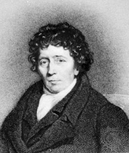
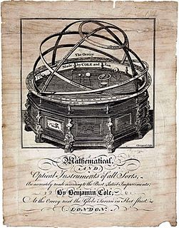
WBenjamin Cole (1695–1766) was an English surveyor, cartographer, instrument maker, engraver and bookbinder living in Oxford. His sons William and Benjamin were also instrument makers in London, while another son, Maximilian, was an engraver in Oxford.
 W
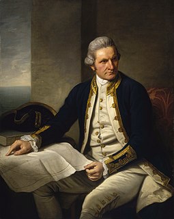
WCaptain James Cook was a British explorer, navigator, cartographer, and captain in the British Royal Navy. He made detailed maps of Newfoundland prior to making three voyages to the Pacific Ocean, during which he achieved the first recorded European contact with the eastern coastline of Australia and the Hawaiian Islands, and the first recorded circumnavigation of New Zealand.
 W
WGeorge Frederick Cruchley (1797-1880) was an English map-maker, engraver and publisher based in London.
 W
WRobert Kearsley Dawson (1798–1861) was an English surveyor and cartographer.
 W
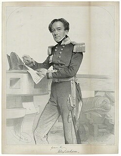
WVice Admiral Sir Henry Mangles Denham was a Royal Navy officer who went on to be Commander-in-Chief, Pacific Station.
 W
WSir Robert Dudley was an English explorer and cartographer. In 1594, he led an expedition to the West Indies, of which he wrote an account. The illegitimate son of Robert Dudley, 1st Earl of Leicester, he inherited the bulk of the Earl's estate in accordance with his father's will, including Kenilworth Castle. In 1603–1605, he tried unsuccessfully to establish his legitimacy in court. After that he left England forever, finding a new existence in the service of the grand dukes of Tuscany. There, he worked as an engineer and shipbuilder, and designed and published Dell'Arcano del Mare (1645-1646), the first maritime atlas to cover the whole world. He was also a skilled navigator and mathematician. In Italy, he styled himself "Earl of Warwick and Leicester", as well as "Duke of Northumberland", a title recognized by Emperor Ferdinand II.
 W
WPeter Fidler was a British surveyor, map-maker, fur trader and explorer who had a long career in the employ of the Hudson's Bay Company (HBC) in what later became Canada. He was born in Bolsover, Derbyshire, England and died at Fort Dauphin in present-day Manitoba. He married Mary Mackagonne, a Cree woman, and together they had 14 children.
 W
WCaptain Matthew Flinders was an English navigator and cartographer who led the first inshore circumnavigation of the landmass that is now known as Australia. He is also credited as being the first person to utilise the name Australia to describe the entirety of that continent including Van Diemen's Land, a title he regarded as being "more agreeable to the ear" than previous names such as Terra Australis.
 W
WFuller is a British artist known for his intricate drawings and map art of cities and places that he explores. He drafts impressionistic "mind maps" of places where he has lived. Fuller is the pen name of Gareth Fuller of London, England, who was previously known as Gareth Wood. Fuller, who says he has always enjoyed exploring and getting lost, observes contemporary culture and investigates urban existence through his art, while telling stories, provoking conversation and "celebrating the identity of places in all their glory". Fuller became an Irish Citizen in 2018.
 W
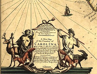
WJoel Gascoyne was an English nautical chartmaker, land cartographer and surveyor who set new standards of accuracy and pioneered large scale county maps. After achieving repute in the Thames school of chartmakers, he switched careers and became one of the leading surveyors of his day and a maker of land maps. He is best known for his maps of: the colonial Province of Carolina; of the county of Cornwall; and of the early 18th-century Parish of Stepney, precursor of today's East End of London. Gascoyne's distinctive style of chart and map-drawing was characterised by the use of bold and imaginative cartouches.
 W
WJohn Gibson was an English cartographer, geographer, draughtsman and engraver.
 W
WMoses Glover, was an English cartographer. He described himself as "paynter And Architectur", although very little is known about him apart from his maps and the church records. Glover's marriage licence, issued in 1622, described him as "painter-stainer of Isleworth". In 1635 he created a survey map of Isleworth Hundred for Algernon Percy, 10th Earl of Northumberland. It is preserved at the Syon House in London.
 W
WCharles Edward Goad was a noted cartographer and civil engineer. Goad is most noted for his insurance surveys of cities in Canada, Great Britain, and elsewhere. Fire insurance companies needed to know in detail the nature and size of buildings, width of streets, construction, building materials and the proximity of fire services and water supplies in order to estimate appropriate premiums. Goad established a company in 1875 in Montreal, Quebec, Canada to produce maps to provide this information. These and like maps are now referred to as Goad maps. Goad returned to England in 1885 and began work in Britain.
 W
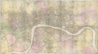
WRichard Horwood was a surveyor and cartographer. He is mainly remembered for his large-scale plan of London and its suburbs published in 32 sheets between 1792 and 1799. He also published a plan of Liverpool in six sheets in 1803.
 W
WThomas Jefferys, "Geographer to King George III", was an English cartographer who was the leading map supplier of his day. He engraved and printed maps for government and other official bodies and produced a wide range of commercial maps and atlases, especially of North America.
 W
WPhilip Lea was an English cartographer, globemaker, instrument maker, and publisher. He was a prolific printer and reviser of maps, frequently collaborating with other contemporary mapmakers including Herman Moll, Robert Morden, John Ogilby, and John Seller.
 W
WClement St. George Royds Littledale and his wife Teresa Harris (Scott)(1839–1928) were known in their time as the greatest British Central Asia travellers of the nineteenth century. Littledale is also considered by many hunters to be one of the greatest big game hunters of all time. He hunted horned game, the sheep and goats, that lived in the mountains of the northern hemisphere, and he collected for the Natural History Museum in London.
 W
WEmery Molyneux was an English Elizabethan maker of globes, mathematical instruments and ordnance. His terrestrial and celestial globes, first published in 1592, were the first to be made in England and the first to be made by an Englishman.
 W
WCaptain John Montresor was a British military engineer and cartographer in North America.
 W
WRobert Morden was an English bookseller, publisher, and mapmaker, globemaker and engraver. He was among the first successful commercial map makers.
 W
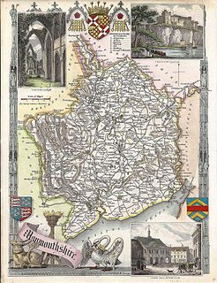
WThomas Moule was an English antiquarian, writer on heraldry, and one of Victorian England's most influential map-makers. He is best known for his popular and highly decorated county maps of England, steel-engraved and first published separately between 1830 and 1832.
 W
WJohn Norden was an English cartographer, chorographer and antiquary. He planned a series of county maps and accompanying county histories of England, the Speculum Britanniae. He was also a prolific writer of devotional works.
 W
WLaurence Nowell was an English antiquarian, cartographer and pioneering scholar of Anglo-Saxon language and literature.
 W
WMatthew Paris, known as Matthew of Paris, was a Benedictine monk, English chronicler, artist in illuminated manuscripts and cartographer, based at St Albans Abbey in Hertfordshire. He wrote a number of works, mostly historical, which he scribed and illuminated himself, typically in drawings partly coloured with watercolour washes, sometimes called "tinted drawings". Some were written in Latin, some in Anglo-Norman or French verse.
 W
WPhyllis Isobella Pearsall MBE was a British painter and writer who founded the Geographers' A-Z Map Company, for which she is regarded as one of the most successful business people of the twentieth century. She has erroneously been credited with creating London's first popular indexed street map.
 W
WGeorge Perry was an English engineer, ironmaster, merchant, draughtsman and cartographer.
 W
WGeorge Philip (1800–1882) was a cartographer, map publisher and founder of the publishing house George Philip & Son Ltd.
 W
WJohn Pine (1690–1756) was an English designer, engraver, and cartographer notable for his artistic contribution to the Augustan style and Newtonian scientific paradigm that flourished during the British Enlightenment.
 W
WJohn Purdy (1773–1843) was an important English hydrographer. His work and influence extended beyond hydrography with the coinage of the term pharology, the study of modern lighthouses and their designs. Purdy's work Memoir, descriptive and explanatory, to accompany the New Chart of the Atlantic Ocean was adapted and improved; continuing to be released in its fifteenth edition fifty years after his death.
 W
WLewis Fry Richardson, FRS was an English mathematician, physicist, meteorologist, psychologist and pacifist who pioneered modern mathematical techniques of weather forecasting, and the application of similar techniques to studying the causes of wars and how to prevent them. He is also noted for his pioneering work concerning fractals and a method for solving a system of linear equations known as modified Richardson iteration.
 W
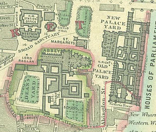
WJohn Rocque was a French-born British surveyor and cartographer, best known for his detailed map of London published in 1746.
 W
WJohn Rudd was a Tudor cartographer and clergyman.
 W
WThomas Sandby was an English draughtsman, watercolour artist, architect and teacher. In 1743 he was appointed private secretary to the Duke of Cumberland, who later appointed him Deputy Ranger of Windsor Great Park, where he was responsible for considerable landscaping work.
 W
WChristopher Saxton was an English cartographer who produced the first county maps of England and Wales.
 W
WWilliam Schmollinger was a famous cartographer.
 W
WCyprian Southack was an English cartographer and colonial naval commander. He commanded the Province Galley, Massachusetts' one-ship navy (1696–1711) and commanded the first navy ship of Nova Scotia, the ship William Augustus (1721–23).
 W
WJohn Speed was an English cartographer and historian. He is, alongside Christopher Saxton, one of the best known English mapmakers of the early modern period.
 W
WJohn Spilsbury was a British cartographer and engraver. He is credited as the inventor of the jigsaw puzzle. Spilsbury created them for educational purposes, and called them “Dissected Maps”. https://www.eschat.net
 W
WEdward Stanford was the founder of Stanfords, now a pair of map and book shops based in London and Bristol, UK.
 W
WJohn Tallis was an English cartographic publisher. His company, John Tallis & Company, published views, maps and atlases in London from roughly 1838 to 1851.
 W
WDavid Thompson was a British-Canadian fur trader, surveyor, and cartographer, known to some native peoples as Koo-Koo-Sint or "the Stargazer". Over Thompson's career, he traveled some 90,000 kilometres (56,000 mi) across North America, mapping 4.9 million square kilometres of North America along the way. For this historic feat, Thompson has been described as the "greatest practical land geographer that the world has produced".
 W
WJohn Warburton (1682–1759) was an antiquarian, cartographer, and Somerset Herald of Arms in Ordinary at the College of Arms in the early 18th century.
 W
WJohn White was an English colonial governor, explorer, artist, and cartographer. White was among those who sailed with Richard Grenville in the first attempt to colonize Roanoke Island in 1585, acting as artist and mapmaker to the expedition. He would most famously briefly serve as the governor of the second attempt to found Roanoke Colony on the same island in 1587 and discover the colonists had mysteriously vanished.
 W
WRobert Wilkinson was an English map maker and atlas publisher.
 W
WJohn Francon Williams FRGS was a Welsh writer, geographer, historian, journalist, cartographer, and inventor, born in Llanllechid, Caernarvonshire. His seminal work was The Geography of the Oceans.
 W
WMajor-General Sir Charles William Wilson, KCB, KCMG, FRS was a British Army officer, geographer and archaeologist.
 W
WEdward Wright was an English mathematician and cartographer noted for his book Certaine Errors in Navigation, which for the first time explained the mathematical basis of the Mercator projection by building on the works of Pedro Nunes, and set out a reference table giving the linear scale multiplication factor as a function of latitude, calculated for each minute of arc up to a latitude of 75°. This was in fact a table of values of the integral of the secant function, and was the essential step needed to make practical both the making and the navigational use of Mercator charts.
 W
WJames Wyld (1812–1887) was a British geographer and map-seller, best known for Wyld's Great Globe.