 W
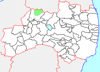
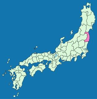
WAdachi is a district located in Fukushima Prefecture, Japan. As of January 2007, the district has a population of 8,577 and an area of 79.46 km2, for a population density of 107.9 per km2.
 W
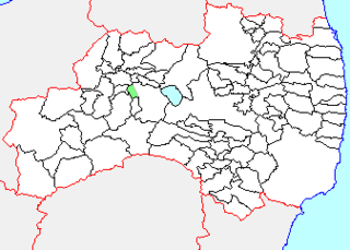
WAdachi was a town located in Adachi District, Fukushima Prefecture, Japan.
 W
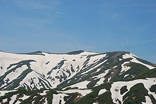
WMount Adatara is a stratovolcano in Fukushima Prefecture, Japan.
 W
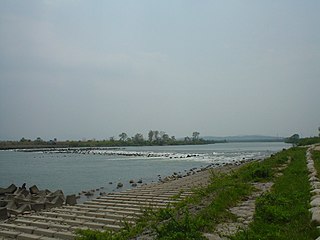
WThe Agano River is a river in the Hokuriku region of Honshu, Japan. It is also called the Aga River or the Ōkawa River in Fukushima.
 W
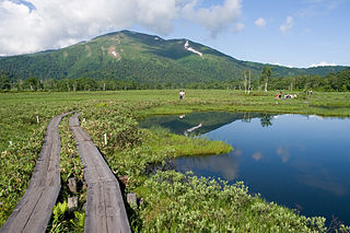
WMount Aizu-Komagatake is a mountain located in Hinoemata, Fukushima Prefecture, Japan, in the Oze National Park. It is one of the 100 Famous Japanese Mountains.
 W
WAizuhongō was a town located in Ōnuma District, Fukushima Prefecture, Japan.
 W
WAizutakada was a town located in Ōnuma District, Fukushima Prefecture, Japan.
 W
WAtsushiokanō was a village located in Yama District, Fukushima Prefecture, Japan.
 W
WDate is a district located in Fukushima Prefecture, Japan.
 W
WFukushima city concert hall is a concert hall in Fukushima city, Fukushima Prefecture, Japan. It opened in 1984 and has a shoebox-style auditorium with 1,000 seats and a smaller hall with a capacity of 200. Okada & Associates were the architects, with acoustical design by Nagata Acoustics. The 41 stop organ is by Marcussen.
 W
WFutaba is a district located in Fukushima Prefecture, Japan.
 W
WGoshiki-numa (五色沼), is a cluster of five volcanic lakes situated at the foot of Mount Bandai in the center of the lake district of Bandai-kōgen, Kitashiobara, Fukushima, Japan.
 W
WHaramachi was a city located in Fukushima Prefecture, Japan.
 W
WHigashi was a village located in Nishishirakawa District, Fukushima Prefecture, Japan.
 W
WHigashishirakawa is a district located in Fukushima Prefecture, Japan.
 W
WHiuchi, also Hiuchigatake is a 2,356m tall stratovolcano mountain in Oze National Park, and located in Hinoemata Village, Minami-Aizu gun, Fukushima Prefecture, Japan. This is the highest mountain in Tōhoku region. The volcano rises in the north of Lake Ozenuma. It is one of the 100 Famous Japanese Mountains.
 W
WMount Iide is the main peak of the Iide mountain range that spans the Fukushima, Niigata and Yamagata prefectures in Japan. On top of the mountain stands the Mount Iide Shrine (飯豊山神社). Mount Iide is, together with the rest of the range, one of the mountains described in Kyūya Fukada's book 100 Famous Japanese Mountains.
 W
WIino was a town located in Date District, Fukushima Prefecture, Japan.
 W
WIshikawa is a district located in Fukushima Prefecture, Japan.
 W
WIwaki Green Stadium is a stadium in Iwaki, Fukushima, Japan. It opened in 1995 and holds 30,000 people. Its design was based on that of Chiba Marine Stadium, and it is used primarily used for baseball. The stadium hosts high school, university and amateur baseball and softball events, and one-two professional baseball games per year. It hosted one NPB All-Star Game in 2013.
 W
WIwaki Province was an old province in the area that is today Fukushima Prefecture and Miyagi Prefecture.
 W
WIwaki was an old province in the area that is today Fukushima Prefecture. It was sometimes called Banshū (磐州).
 W
WIwase is a district located in Fukushima Prefecture, Japan.
 W
WIwase was a village located in Iwase District, Fukushima Prefecture, Japan.
 W
WIwashiro Province is an old province in the area of Fukushima Prefecture. It was sometimes called Ganshū (岩州).
 W
WIwashiro was a town located in Adachi District, Fukushima Prefecture, Japan.
 W
WKashima was a town located in Sōma District, Fukushima Prefecture, Japan.
 W
WKawahigashi was a town located in Kawanuma District, Fukushima Prefecture, Japan.
 W
WKawanuma is a district located in Fukushima Prefecture, Japan.
 W
WKitaaizu was a district located in Fukushima Prefecture, Japan.
WKitaaizu was a village located in the former Kitaaizu District, Fukushima Prefecture, Japan.
 W
WLake Hibara is a lake located in Yama District, Fukushima, Japan. It is a part of the Bandai-Asahi National Park and is the largest of the lakes in the Bandai-kōgen highlands.
 W
WLake Inawashiro is the fourth-largest lake in Japan, located in central Fukushima Prefecture, south of Mount Bandai. It is also known as the 'Heavenly Mirror Lake' . The lake is located within the borders of Bandai-Asahi National Park. It is a surface area of 104 square kilometres (40 sq mi), circumference of 63 kilometres (39 mi), depth of 94 metres (308 ft) and is located at an altitude of 514 metres (1,686 ft). In winter swans migrate to the beaches of the lake and stay there until spring.
 W
WMinamiaizu is a district located in Fukushima Prefecture, Japan. It makes up the southern third of the Aizu region in western Fukushima Prefecture.
 W
WMount Nekomadake is a stratovolcano located west of Mount Bandai, close to Bandai town and Kitashiobara village in the Fukushima Prefecture, Japan. It is 1,403.6 metres high, and close to Lake Inawashiro and Oguni-numa Pond.
 W
WNaganuma was a town located in Iwase District, Fukushima Prefecture, Japan.
 W
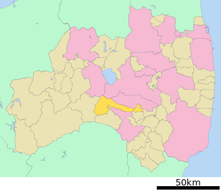
WNakadōri is a region comprising the middle third of Fukushima Prefecture, Japan. It is sandwiched between the regions of Aizu to the west and Hamadōri to the east. The principal cities of the area are Kōriyama and the prefecture's capital, Fukushima.
 W
WNangō was a former village located in Minamiaizu District, Fukushima Prefecture, Japan.
 W
WNiitsuru was a village located in Ōnuma District, Fukushima Prefecture, Japan.
 W
WNishishirakawa is a district located in Fukushima Prefecture, Japan.
 W
WOdaka was a town located in Sōma District, Fukushima, Japan.
 W
WOguni-numa Pond is a pond located at the western base of Mount Nekomadake in Fukushima Prefecture, Japan. The pond is situated on the remains of a crater and has a circumference of 4 km and an area of 45 hectares. It is considered a national monument.
 W
WOmotegō was a village located in Nishishirakawa District, Fukushima Prefecture, Japan.
 W
WŌnuma is a district located in Fukushima Prefecture, Japan.
 W
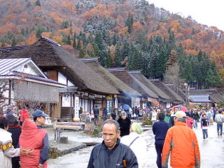
WŌuchi-juku was a small post station in Japan's Edo period and part of the Aizu Nishi Kaidō. It is now located in the town of Shimogō in Minamiaizu District, Fukushima Prefecture, and is famous for the numerous traditional thatched buildings from the Edo Period that line its main street.
 W
WOze National Park , is an area consisting of open greenland in Fukushima, Tochigi, Gunma and Niigata Prefectures in Japan. The park is 372 km² in area and is the 29th national park in Japan.
 W
WSanjō Falls is a waterfall in Hinoemata, Fukushima Prefecture, Japan, on the Tadami River in Oze National Park. It is one of "Japan’s Top 100 Waterfalls", in a listing published by the Japanese Ministry of the Environment in 1990.
 W
WShiokawa was a town located in Yama District, Fukushima Prefecture, Japan.
 W
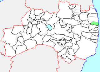
WSōma is a district located in Fukushima Prefecture, Japan.
 W
WTaishin was a village located in Nishishirakawa District, Fukushima Prefecture, Japan.
 W
WTakasato was a village in Yama District, Fukushima Prefecture, Japan.
 W
WTakine was a town located in Tamura District, Fukushima Prefecture, Japan.
 W
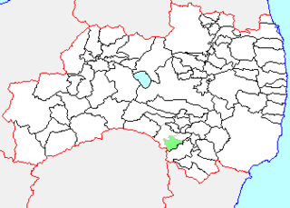
WTamura is a district located in Fukushima Prefecture, Japan.
 W
WTenjin Beach is a recreational beach on Lake Inawashiro in Fukushima Prefecture, Japan. On August 18, 1925, Tenjin Beach was the site of the first Boy Scouts of Japan camping trip. Members of the Imperial Family, including Crown Prince Hirohito and Prince Chichibu, attended the event. In winter, strong winds and waves form natural ice sculptures on shoreline vegetation, attracting many amateur photographers to a 1 kilometer stretch of Tenjin Beach.
 W
WTō-no-Hetsuri is a 200 metre long, natural cliff formation located in Ōkawa Hatori Prefectural Park in Shimogō in Fukushima, Japan.
 W
WTōwa was a town located in Adachi District, Fukushima Prefecture, Japan.
 W
WYama is a district located in Fukushima Prefecture, Japan.
 W
WYamato was a town located in Yama District, Fukushima Prefecture, Japan. The town was established as a village in 1875, and promoted to a town in 1954.