 W
WThe geography of Sydney is characterised by its coastal location on a basin bordered by the Pacific Ocean to the east, the Blue Mountains to the west, the Hawkesbury River to the north and the Woronora Plateau to the south. Sydney lies on a submergent coastline on the east coast of New South Wales, where the ocean level has risen to flood deep river valleys (rias) carved in the Sydney sandstone. Port Jackson, better known as Sydney Harbour, is one such ria.
 W
WThe ecology of Sydney, located in the state of New South Wales, Australia, is diverse for its size, where it would mainly feature biomes such as grassy woodlands and some sclerophyll forests, with a few pockets of mallee shrublands, subtropical and temperate rainforests (evergreen), heathlands, and wetlands. The combination of climate, topography, moisture, and soil influence the dispersion of these ecological communities across a height gradient from 0 to 200 metres. There are many hiking trails, paved and unpaved roads for exploring the many different biomes and ecosystems.
 W
WThe Basin is a locality in northern Sydney, in the Australian state of New South Wales. The Basin is located 42 kilometres north of the Sydney central business district, in the local government area of Pittwater Council.
 W
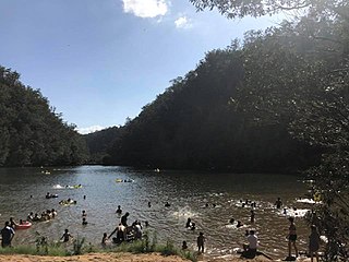
WBents Basin is a protected nature reserve and state park near Wallacia, New South Wales, Australia in the Sydney metropolitan area. The lake basin, which formed at the efflux of the Nepean River from the Hawkesbury Sandstone gorge, is a popular swimming hole with a camping area and an education centre used by local school groups. Also featuring a large woodland area and native wildlife, the reserve is the only picnic area along the Nepean River and it is one of the most popular water-based picnic parks in Greater Western Sydney.
 W
WThe Blue Gum High Forest of the Sydney Basin Bioregion is one of six main indigenous forest communities of Sydney, Australia. It has been classified as critically endangered, under the New South Wales government's Threatened Species Conservation Act 1995. The principal canopy trees in this forest community are Sydney blue gum and blackbutt which are usually seen between 20 and 40 metres tall. 180 species of indigenous plants have been identified at Dalrymple-Hay Nature Reserve.
 W
WBradleys Head is a headland protruding from the north shore of Sydney Harbour, within the metropolitan area of Sydney, New South Wales, Australia. It is named after the First Fleet naval officer William Bradley. The original Aboriginal inhabitants belonged to the Borogegal clan of the Eora nation, and was known as Borogegy, Booraghee, Booragy or Burrogy. Also on the headland is an active lighthouse, Bradleys Head Light, constructed in 1905.
 W
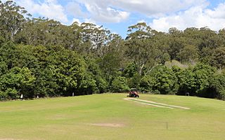
WBrowns Field is located in Fox Valley Wahroonga, 17 km (11 mi) north-west from Sydney, in the state of New South Wales, Australia. It contains a small sporting ground and a bushland reserve. A unique rainforest grows nearby, due to enriched soils from ancient volcanic activity.
 W
WChipping Norton Lake is a 49-hectare (120-acre) artificial lake and regional park located in the Sydney suburb of Chipping Norton, New South Wales, Australia. It is a part of the Georges River system. Chipping Norton Lake is managed by Liverpool City Council. The lake is an important recreational area for Liverpool, City of Canterbury-Bankstown and Fairfield City Council.
 W
WThe climate of Sydney is humid subtropical, shifting from mild and cool in winter to warm and hot in the summer, with no extreme seasonal differences as the weather is moderated by proximity to the ocean, although more contrasting temperatures are recorded in the inland western suburbs. Despite the fact that there is no distinct dry or wet season, rainfall peaks in the first half of the year and is at its lowest in the second half, though rainfall can be erratic throughout the year. Precipitation varies across the region, with areas adjacent to the coast being the wettest. The city receives around 20 thunderstorms per year. According to the Bureau of Meteorology, Sydney falls in the temperate climate zone which has warm to hot summers and no dry season.
 W
WSevere storm events in Sydney are not uncommon and would include hail storms, wind storms, and flash flooding from rain caused either by East coast lows or ex-tropical cyclone remnants. East coast lows are low pressure depressions that can bring significant damage by heavy rain, cyclonic winds and huge swells. Sydney is rarely affected by cyclones, although remnants of ex-cyclones do affect the city.
 W
WClive Evatt Reserve and Turiban Reserve are two forest remnants situated on Burns Road, Wahroonga, in Sydney, Australia. Both are of a high conservation status, being some of the last remnants of the critically endangered Blue Gum High Forest in the Sydney basin. Turiban has some of the tallest forest trees in Sydney, some blackbutt exceeding 45 metres tall. Forest restoration programs have been in progress for many years. The weeds ochna and privet being particularly troublesome. Foxes are an invasive mammal species. "Turiban" is said to be a clan of Indigenous Australians who lived north of Sydney.
 W
WCockle Bay is a small bay in inner-city Sydney, New South Wales, Australia. It is located on the western edge of the Sydney central business district.
 W
WCronulla Beach, is a patrolled beach on Bate Bay, in Cronulla, New South Wales, Australia. The Cronulla Pavilion and the Cronulla Lifesaving Club are two prominent buildings located close to the sand. Cronulla Park sits behind the beach. The Cronulla Rock Pools are between Cronulla Beach and North Cronulla beach. The Alley is the local name given to the area between Cronulla Beach and North Cronulla Beach. Shark Island is a dangerous reef break, located off Cronulla Beach.
 W
WCumberland County is a county in the State of New South Wales, Australia. Most of the Sydney metropolitan area is located within the County of Cumberland.
 W
WThe Cumberland Plain, an IBRA biogeographic region, is a relatively flat region lying to the west of Sydney CBD in New South Wales, Australia. Cumberland Basin is the preferred physiographic and geological term for the low-lying plain of the Permian-Triassic Sydney Basin found between Sydney and the Blue Mountains, and it is a structural sub-basin of the Sydney Basin.
 W
WThe Cumberland Plain Woodland is one of six main indigenous woodland communities of Sydney, New South Wales, Australia, that comprises an open tree canopy, a groundcover with grasses and herbs, usually with layers of shrubs and/or small trees. Situated in the Cumberland Plain, it is made up of dry sclerophyll woodlands, grasslands and/or forests, reminiscent of Mediterranean forests and temperate grasslands.
 W
WCurlew Camp was an artists' camp established in the late 19th century on the eastern shore of Little Sirius Cove, now part of Mosman Bay in Sydney. It was home for some years to several leading Australian artists, such as Arthur Streeton and Tom Roberts of the Heidelberg School, and it was from here that some of their most famous paintings were created. Today the site is still in its natural state and the Mosman Council has built a foreshore walk called the "Curlew Camp Artist's Walk" which traces the journey that the residents of the camp followed when they disembarked from the ferry at South Mosman ferry wharf, then known as "Musgrave Street Wharf," and returned to the camping site. The walk starts at the wharf and continues along the harbour's edge for 1.6 km until it finishes at Taronga Zoo Wharf.
 W
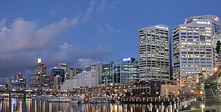
WDarling Harbour is a harbour adjacent to the city centre of Sydney, New South Wales, Australia that is made up of a large recreational and pedestrian precinct that is situated on western outskirts of the Sydney central business district.
 W
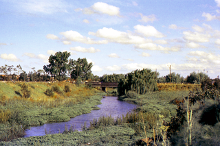
WThe Duck River is a perennial stream and southern tributary of the Parramatta River, in Sydney, New South Wales, Australia.
 W
WElouera Beach or Elouera is a patrolled beach on Bate Bay, in Cronulla, New South Wales, Australia. The Wall is the local name given to the area between North Cronulla Beach and Elouera.
 W
WFarm Cove is a tidal inlet and shallow bay in Sydney Harbour, separated from Sydney Cove by Bennelong Point, New South Wales, Australia. Known to the indigenous inhabitants of Sydney as Woccanmagully, Farm Cove was used by them as an initiation ground and for the "Kangaroo and Dog Dance".
 W
WFerndale Park is located in suburban Chatswood, 8 km (5 mi) from the centre of Sydney, Australia. It is an important urban forest reserve, preserving Blackbutt forest and the mossy gully rainforest. Most of this original forest was cleared for agriculture and housing in the 19th and 20th century.
 W
WThe Field of Mars Reserve is a protected nature reserve located in the north–western suburbs of Sydney, in the state of New South Wales, Australia. The 50 Hectare reserve is a remnant of bushland situated between the Lane Cove and Parramatta rivers within the suburb of East Ryde and near Gladesville, Hunters Hill and Ryde.
 W
WThe Gap is an ocean cliff on the South Head peninsula in eastern Sydney, New South Wales, Australia. The area, which faces the Tasman Sea, is located in the eastern suburb of Watsons Bay, in the Municipality of Woollahra, near South Head. Although the cliff is a popular visitor destination, it has an infamy for suicides.
 W
WGreenhills Beach is an unpatrolled beach on Bate Bay, located in Kurnell, New South Wales. The beach is located roughly 18 kilometres from the Sydney central business district, in the local government area of the Sutherland Shire. Recognised as one of Sydney's longest beaches, Greenhills beach is roughly 3 kilometres in length and forms part of a chain of beaches residing on Bate Bay. It is the northernmost section of the Greenhills-North Cronulla beach complex and is the only section of the beach not to be patrolled by a Surf Club or by volunteer lifesavers.
 W
WThe Gunnamatta Bay is a small bay in southern Sydney, New South Wales, Australia.
 W
WThe Hornsby Plateau is a sandstone plateau lying to the north of Sydney Harbour, which rises to 200 metres and is dissected by steep valleys. The plateau is part of a larger geological structure named the Sydney Basin.
 W
WLake Parramatta is a heritage-listed man-made reservoir and a recreational area located in North Parramatta, City of Parramatta, in the Western Sydney region of New South Wales, Australia. The masonry arch-walled dam across Hunts Creek was completed in 1856 to supply water for domestic purposes; and was operational until 1909. The dam has since been decommissioned and the lake and the surrounding nature reserve are a popular recreational area.
 W
WLane Cove Bushland Park is located in suburban Lane Cove, 5 kilometres from the centre of Sydney, Australia. It is regarded as one of the more interesting areas of fungi in the country. In the year 2000, Bushland Park was placed on the Register of the National Estate, under the Australian Heritage Commission Act, 1975. Average annual rainfall is 1220 mm. Soils are moderately fertile, based on Hawkesbury sandstone and Ashfield Shale. The climate is warm and humid.
 W
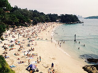
WThe city of Sydney, Australia, is home to some of the finest and most famous beaches in the world. There are well over 100 beaches in the city, ranging in size from a few metres to several kilometres, located along the city's Pacific Ocean coastline and its harbours, bays and rivers.
 W
WThe Malabar Headland is a heritage-listed former public recreation area and military installation site and now nature conservation and public recreation headland area located at Franklin Street, Malabar in the City of Randwick local government area of New South Wales, Australia. It is also known as Long Bay Rifle Range, Anzac Rifle Range and Boora Point. The property is owned by the New South Wales Government. It was added to the New South Wales State Heritage Register on 22 July 2005.
WThe Manly Dam Reserve, also known as the Manly Warringah War Memorial Park, is an urban bushland reserve located in the Northern Beaches region of Sydney, Australia. The reserve adjoins the south-eastern edge of Garigal National Park.
 W
WMiddle Harbour, a semi–mature tide dominated drowned valley estuary, is the northern arm of Port Jackson, an inlet of the Tasman Sea located north of Sydney central business district on the coast of New South Wales, Australia.
WThe Muogamarra Nature Reserve is a protected nature reserve that is located in the Sydney region of New South Wales, in eastern Australia. The 2,274-hectare (5,620-acre) reserve is situated in the northern edge of Sydney and lies between the suburb of Cowan to the south, and the Hawkesbury River to the north.
 W
WNorfolk Reserve is located in suburban Greenacre, 14 km (9 mi) from the centre of Sydney, Australia. An isolated bushland remnant surrounded by a heavily industrialized and urban area. Listed rare species of plants recorded in this reserve include the downy wattle and the vine Vincetoxicum woollsii.
 W
WNorth Cronulla Beach or North Cronulla is a patrolled beach on Bate Bay, in Cronulla, New South Wales, Australia. The Wall is the local name given to the area between North Cronulla Beach and Elouera. The Alley is the local name given to the permanent rip current located at the southern end of North Cronulla Beach.
 W
WPort Jackson, consisting of the waters of Sydney Harbour, Middle Harbour, North Harbour and the Lane Cove and Parramatta Rivers, is the ria or natural harbour of Sydney, New South Wales, Australia. The harbour is an inlet of the Tasman Sea. It is the location of the Sydney Opera House and Sydney Harbour Bridge. The location of the first European settlement and colony on the Australian mainland, Port Jackson has continued to play a key role in the history and development of Sydney.
 W
WProspect Hill is a heritage-listed hill in Pemulwuy and Prospect in the greater western region of Sydney, New South Wales, Australia. Situated about 30 kilometres west of central Sydney, the hill is Sydney's largest body of igneous rock and is higher than the ridges of the Cumberland Plain around it, with its present-day highest point being 117 metres high, although before its summit was quarried away it rose to a height of 131 metres above sea level.
 W
WThe Prospect Reservoir is a heritage-listed 50,200-megalitre potable water supply and storage reservoir created by the Prospect Dam, across the Prospect Creek located in the Western Sydney suburb of Prospect, in New South Wales, Australia. The eastern bounds of the reservoir are a recreational area and the western periphery are within the bounds of Western Sydney Parklands. It was added to the New South Wales State Heritage Register on 18 November 1999.
 W
WThe Scheyville National Park is a protected national park that is located in the northwestern suburbs of Sydney in New South Wales, in eastern Australia. The 920-hectare (2,300-acre) national park is situated approximately 40 kilometres (25 mi) northwest of the Sydney central business district, northeast of Windsor, near the settlement of Scheyville. Longneck Lagoon lies in the northern section of the park. It was added to the New South Wales State Heritage Register on 9 April 2010.
 W
WSheldon Forest is a pocket of urban bushland located 17 kilometres (11 mi) north-west of Sydney, Australia in a narrow valley between Turramurra and Pymble.
 W
WShelly Beach is a beach on Bate Bay in Cronulla, New South Wales, Australia. Shelly Park sits behind the beach. Shelly Pavilion is located between the beach and the park.
 W
WSow and Pigs Reef is a rocky reef in Sydney Harbour, New South Wales, Australia. The reef is situated on the eastern side of the main shipping channel between Middle Head and South Head. It is 150 metres (490 ft) long and up to 70 metres (230 ft) wide. Originally the reef was exposed and resembled a sow and her litter. Explosives were used to reduce the reef, however, and now the reef is only exposed at a very low tide. A number of ships have been wrecked or damaged after hitting the reef.
WPort Jackson, consisting of the waters of Sydney Harbour, Middle Harbour, North Harbour and the Lane Cove and Parramatta Rivers, is the ria or natural harbour of Sydney, New South Wales, Australia. The harbour is an inlet of the Tasman Sea. It is the location of the Sydney Opera House and Sydney Harbour Bridge. The location of the first European settlement and colony on the Australian mainland, Port Jackson has continued to play a key role in the history and development of Sydney.
 W
WThe Sydney Harbour National Park is an Australian national park comprising parts of Port Jackson, Sydney and its foreshores and various islands. The 392-hectare (970-acre) national park lies in New South Wales and was created progressively, from 1975.
 W
WThe Sydney Heads are a series of headlands that form the 2 km (1.2 mi) wide entrance to Sydney Harbour in Sydney, New South Wales, Australia. North Head and Quarantine Head are to the north; South Head and Dunbar Head are to the south; and Middle Head, Georges Head, and Chowder Head are to the west and within the harbour. The Heads are contained within the Sydney Harbour National Park.
 W
WThe Sydney punchbowls, made in China during the Jiaqing Emperor's reign (1796–1820) over the mid-Qing dynasty, are the only two known examples of Chinese export porcelain hand painted with Sydney scenes and dating from the Macquarie era. The bowls were procured in Canton about three decades after the First Fleet's arrival at Port Jackson where the British settlement at Sydney Cove was established in 1788. They also represent the trading between Australia and China via India at the time. Even though decorated punchbowls were prestigious items used for drinking punch at social gatherings during the 18th and 19th centuries, it is not known who originally commissioned these bowls or what special occasion they were made for.
WSydney Sandstone Gully Forest is a vegetation community found in Sydney, Australia.
 W
WThe Sydney Sandstone Ridgetop Woodland is one of six main indigenous forest communities of Sydney, Australia. An area of high biodiversity, existing on poor sandstone soils, with regular wildfires, and a high rainfall by Australian standards.
 W
WThe Sydney Turpentine-Ironbark Forest (STIF) is one of six main indigenous forest communities of Sydney, New South Wales, Australia, that is typically in the Inner West region of Sydney. It is also among the three of these plant communities which have been classified as Endangered, under the New South Wales government's Threatened Species Conservation Act 1995, with only around 0.5% of its original pre-settlement range remaining. As of 26 August 2005, the Australian Government reclassified Sydney Turpentine-Ironbark Forest as a "Critically Endangered Ecological Community", under the Commonwealth's Environment Protection and Biodiversity Conservation Act 1999.
 W
WTarban Creek, a northern tributary of the Parramatta River, is a creek west of Sydney Harbour, in Sydney, New South Wales, Australia.
 W
WThe Towra Point Nature Reserve is a protected nature reserve that is located in Sutherland Shire, southern Sydney, New South Wales, in eastern Australia. The 603-hectare (1,490-acre) reserve is situated on the southern shores of Botany Bay at Kurnell, within the Sutherland Shire. The reserve is protected under the Ramsar Convention as a wetland of international importance as an important breeding ground for many vulnerable, protected, or endangered species. The Towra Point Aquatic Nature Reserve is located in the surrounding waterways.
 W
WTumbalong Park is a park in Darling Harbour, located in Sydney, Australia. The parkland was designed using native Australian foliage incorporated with fountains as an urban stream. The name "Tumbalong" is from Dharug as spoken by the Eora nation and means "place where seafood is found".
 W
WThe Upper Nepean Scheme is a series of dams and weirs in the catchments of the Cataract, Cordeaux, Avon and Nepean rivers of New South Wales, Australia. The scheme includes four dams and two weirs, and a gravity-fed canal system that feeds into a large storage reservoir to provide water to the Macarthur and Illawarra regions, the Wollondilly Shire, and metropolitan Sydney. The four dams and associated infrastructure are individually listed on the New South Wales State Heritage Register.
 W
WWalsh Bay is a bay within Port Jackson, about 1,000 metres (3,300 ft) south of the suburb McMahons Point. It is named after Henry Deane Walsh, Engineer-in-chief of the Sydney Harbour Trust. Walsh Bay is officially defined as that body of water that stretches from the Dawes Point in the north east, to the Millers Point in the southwest and the original shoreline has been altered to include developments now known as Piers 1 to 9.
 W
WWanda Beach or Wanda is the northernmost patrolled beach on Bate Bay in Cronulla, New South Wales, Australia. Green Hills or Green Hills Ridge is the name given to the Cronulla sand dunes, just north of Wanda.
 W
WWarragamba Dam is a heritage-listed dam in the outer South Western Sydney suburb of Warragamba, Wollondilly Shire in New South Wales, Australia. It is a concrete gravity dam, which creates Lake Burragorang, the primary reservoir for water supply for the city of Sydney. The dam wall is located approximately 65 kilometres (40 mi) to the southwest of Sydney central business district, near the town of Wallacia.
 W
WThe Woronora Plateau is a plateau located in New South Wales, Australia. The area is adjacent to the Sydney Plains and is slightly higher in altitude. It is capped with Hawkesbury Sandstone. It is often hotter in summer and colder in winter than metropolitan Sydney. The Woronora River flows through the deeply dissected plateau to the Georges River from near the sources of the Port Hacking, within the Sutherland Shire.