 W
WHuman geography or anthropogeography is the branch of geography that deals with humans and their communities, cultures, economies, and interactions with the environment by studying their relations with and across locations. It analyzes patterns of human social interaction, their interactions with the environment, and their spatial interdependencies by application of qualitative and quantitative research methods.
 W
WThe following article gives a list of Women's association football confederations, sub-confederations and associations around the world.
 W
WIn the engineering and social sciences, the term built environment, or built world, refers to the human-made environment that provides the setting for human activity, ranging in scale from buildings to cities and beyond. It has been defined as "the human-made space in which people live, work and recreate on a day-to-day basis."
 W
WCentral place theory is a geographical theory that seeks to explain the number, size and location of human settlements in a residential system. It was introduced in 1933 to explain the spatial distribution of cities across the landscape. The theory was first analyzed by German geographer Walter Christaller, who asserted that settlements simply functioned as 'central places' providing services to surrounding areas.
 W
WThe observance of Christmas around the world varies by country. The day of Christmas, and in some cases the day before and the day after, are recognized by many national governments and cultures worldwide, including in areas where Christianity is a minority religion. In some non-Christian areas, periods of former colonial rule introduced the celebration ; in others, Christian minorities or foreign cultural influences have led populations to observe the holiday.
 W
WCognitive geography is an interdisciplinary study of cognitive science and geography. It aims to understand how humans view space, place, and environment. It involves the formalization of factors that influence our spatial cognition to create a more effective representation of space. These improved models assist in a variety of issues, for example, the developing maps that communicate better, providing navigation instructions that are easier to follow, utilizing space more practically, accounting for the cultural differences on spatial thinking for more effective cross-cultural information exchange, and an overall increased understanding of our environment.
 W
WA country is a political state, nation, or territory which is controlled. It is often referred to as the land of an individual's birth, residence, or citizenship.
 W
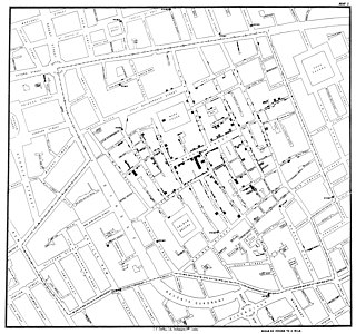
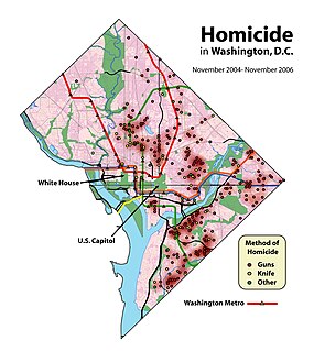
WCrime mapping is used by analysts in law enforcement agencies to map, visualize, and analyze crime incident patterns. It is a key component of crime analysis and the CompStat policing strategy. Mapping crime, using Geographic Information Systems (GIS), allows crime analysts to identify crime hot spots, along with other trends and patterns.
 W
WCritical geography is theoretically informed geographical scholarship that seeks for social justice, liberation, and leftist politics. Critical geography is also used as an umbrella term for Marxist, feminist, postmodern, poststructural, queer, left-wing, and activist geography.
 W
WDemography is the statistical study of populations, especially human beings.
 W
WDesakota is a term used in urban geography used to describe areas in the extended surroundings of large cities, in which urban and agricultural forms of land use and settlement coexist and are intensively intermingled.
 W
WA developed country, industrialized country, more developed country (MDC), or more economically developed country (MEDC), is a sovereign state that has a developed economy and advanced technological infrastructure relative to other less industrialized nations. Most commonly, the criteria for evaluating the degree of economic development are gross domestic product (GDP), gross national product (GNP), the per capita income, level of industrialization, amount of widespread infrastructure and general standard of living. Which criteria are to be used and which countries can be classified as being developed are subjects of debate.
WA developing country is a country with a less developed industrial base (industries) and a low Human Development Index (HDI) relative to other countries. However, this definition is not universally agreed upon. There is also no clear agreement on which countries fit this category. A nation's GDP per capita, compared with other nations, can also be a reference point. In general, the United Nations accepts any country's claim of itself being "developing".
 W
WDevelopment geography is a branch of geography which refers to the standard of living and its quality of life of its human inhabitants. In this context, development is a process of change that affects people's lives. It may involve an improvement in the quality of life as perceived by the people undergoing change. However, development is not always a positive process. Gunder Frank commented on the global economic forces that lead to the development of underdevelopment. This is covered in his dependency theory.
WHuman ecology is an interdisciplinary and transdisciplinary study of the relationship between humans and their natural, social, and built environments. The philosophy and study of human ecology has a diffuse history with advancements in ecology, geography, sociology, psychology, anthropology, zoology, epidemiology, public health, and home economics, among others.
WEconomic geography is the subfield of human geography which studies economic activity. It can also be considered a subfield or method in economics.
WEnvironmental determinism is the study of how the physical environment predisposes societies and states towards particular development trajectories. Many scholars underscore that this approach supported colonialism and eurocentrism, and devalued human agency in non-Western societies. Jared Diamond, Jeffrey Herbst, Ian Morris, and other social scientists sparked a revival of the theory during the late twentieth and early twenty-first centuries. This "neo-environmental determinism" school of thought examines how geographic and ecological forces influence state-building, economic development, and institutions.
 W
WDog agility is now an international dog sport with many different sanctioning organizations and competitions worldwide.
 W
WHalloween, a contraction of "All Hallows' Eve", is a celebration observed on October 31, the day before the feast of All Hallows', also known as Hallowmas or All Saint's Day. The celebrations and observances of this day occur primarily in regions of the Western world, albeit some traditions vary significantly between geographical areas.
 W
WKendo originated in Japan, but is today practiced worldwide.
 W
WA Hagenhufendorf is an elongated settlement, similar to a Reihendorf, laid out along a road running parallel to a stream, whereby only one side of the road has houses, whilst on the opposite side are the hides (Hufen), the handkerchief-shaped farmer's fields of medieval origin, about 20 to 40 morgens in area.
 W
WHealth geography is the application of geographical information, perspectives, and methods to the study of health, disease, and health care.
 W
WHeterotopia is a concept elaborated by philosopher Michel Foucault to describe certain cultural, institutional and discursive spaces that are somehow ‘other’: disturbing, intense, incompatible, contradictory or transforming. Heterotopias are worlds within worlds, mirroring and yet upsetting what is outside. Foucault provides examples: ships, cemeteries, bars, brothels, prisons, gardens of antiquity, fairs, Muslims baths and many more. Foucault outlines the notion of heterotopia on three occasions between 1966-67. A talk given to a group of architects is the most well-known explanation of the term. His first mention of the concept is in his preface to 'The Order of Things' and refers to texts rather than socio-cultural spaces.
 W
WHistorical geography is the branch of geography that studies the ways in which geographic phenomena have changed over time. It is a synthesizing discipline which shares both topical and methodological similarities with history, anthropology, ecology, geology, environmental studies, literary studies, and other fields. Although the majority of work in historical geography is considered human geography, the field also encompasses studies of geographic change which are not primarily anthropogenic. Historical geography is often a major component of school and university curricula in geography and social studies. Current research in historical geography is being performed by scholars in more than forty countries.
 W
WI = PAT is the mathematical notation of a formula put forward to describe the impact of human activity on the environment.I = P × A × T
 W
WIntegrated geography is the branch of geography that describes and explains the spatial aspects of interactions between human individuals or societies and their natural environment, these interactions being called coupled human–environment system. Summed up, environmental geography is about humans and nature and how we affect the environment and our planet.
 W
WThis is a list of island countries. An island is a landmass that is surrounded by water. Many island countries are spread over an archipelago, as is the case with the Federated States of Micronesia and Indonesia. Others consist of a single island, such as Barbados, or part of an island, such as the Dominican Republic. Australia is a a continent, although it is sometimes referred to as an island, as it has no land borders. Two island countries, Northern Cyprus and Taiwan, are not universally recognized as politically independent, but have de facto control over their island territories. Indonesia is the world's largest island country by area, by total number the islands and is the world's most populous island country, with a population of 267,670,543.
 W
WLanguage geography is the branch of human geography that studies the geographic distribution of language(s) or its constituent elements. Linguistic geography can also refer to studies of how people talk about the landscape. For example, toponymy is the study of place names. Landscape ethnoecology, also known as ethnophysiography, is the study of landscape ontologies and how they are expressed in language.
 W
WA linear settlement is a settlement or group of buildings that is formed in a long line. Many of such settlements have transport route, such as a road, river, or canal though some form due to physical restrictions, such as coastlines, mountains, hills or valleys. Linear settlements may have no obvious centre, such as a road junction. Linear settlements have a long and narrow shape.
 W
WThis is a list of all sovereign states and dependencies by total fertility rate (TFR): the expected number of children born per woman in her child-bearing years.
 W
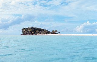
WA desert island, or uninhabited island, is an island, islet or atoll that is not permanently populated by humans. Uninhabited islands are often depicted in films or stories about shipwrecked people, and are also used as stereotypes for the idea of "paradise". Some uninhabited islands are protected as nature reserves and some are privately owned. Devon Island in Canada is the largest uninhabited island in the world.
 W
WA Malthusian catastrophe occurs when population growth outpaces agricultural production, causing population to be limited by famine or war. It is named after Thomas Robert Malthus, who suggested that while technological advances could increase a society's supply of resources, such as food, and thereby improve the standard of living, the resource abundance would enable population growth, which would eventually bring the per capita supply of resources back to its original level. Some economists contend that since the industrial revolution, mankind has broken out of the trap. Others argue that the continuation of extreme poverty indicates that the Malthusian trap continues to operate. Others further argue that due to lack of food availability coupled with excessive pollution, developing countries show more evidence of the trap.
 W
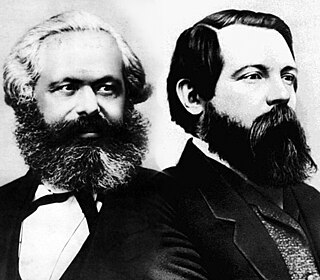
WMarxist geography is a strand of critical geography that uses the theories and philosophy of Marxism to examine the spatial relations of human geography. In Marxist geography, the relations that geography has traditionally analyzed — natural environment and spatial relations — are reviewed as outcomes of the mode of material production. To understand geographical relations, on this view, the social structure must also be examined. Marxist geography attempts to change the basic structure of society.
 W
WGeography of media and communication is an interdisciplinary research area bringing together human geography with media studies and communication theory. Research addressing the geography of media and communication seeks to understand how acts of communication and the systems they depend on both shape and are shaped by geographical patterns and processes.
 W
WMetageography is a term used by Martin W. Lewis and Kären E. Wigen's 1997 The Myth of Continents: A Critique of Metageography, which analyzes metageographical constructs such as "East", "West", "Europe", "Asia", "North" or "South". which they define as "the set of spatial structures through which people order their knowledge of the world" Geographies, wrote one reviewer, are thus much more than just the ways in which societies are stretched across the earth's surface. They also include the "contested, arbitrary, power-laden, and often inconsistent ways in which those structures are represented epistemologically."
 W
WMilitary geography is a sub-field of geography that is used by the military, as well as academics and politicians, to understand the geopolitical sphere through the military lens. To accomplish these ends, military geographers consider topics from geopolitics to physical locations’ influences on military operations and the cultural and economic impacts of a military presence. On a tactical level, a military geographer might put together the terrain and the drainage system below the surface, so a unit is not at a disadvantage if the enemy uses the drainage system to ambush it, especially in urban warfare. On a strategic level, an emerging field of strategic and military geography seeks to understand the changing human and biophysical environments that alter the security and military domains. Climate change, for example, is adding and multiplying the complexity of military strategy, planning and training. Emerging responsibilities for the military to be involved in: protection of civilian populations, women and ethnic groups; provision of humanitarian aid and disaster response (HADR); new technology and domains of training and operations, such as in cybergeography, make military geography a dynamic frontier.If a general desired to be a successful actor in the great drama of war, his first duty is to study carefully the theater of operations so that he may see clearly the relative advantages and disadvantages it presents for himself and his enemies.— Baron De Jomini
 W
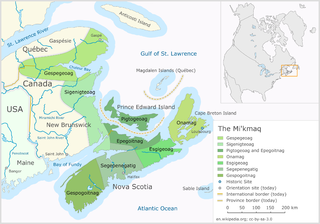
WMiꞌkmaꞌki or Miꞌgmaꞌgi is the traditional and current territories or country of the Miꞌkmaq people. It is shared by an inter-Nation forum between Miꞌkmaq First Nations and is divided into seven geographical and traditional districts, with an eighth representing Taqamkuk today. Miꞌkmaꞌki is one of the confederate countries within Wabanaki.
 W
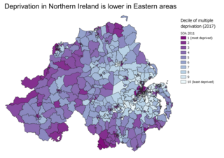
WIndices of multiple deprivation (IMD) are widely-used datasets within the UK to classify the relative deprivation of small areas. Multiple components of deprivation are weighted with different strengths and compiled into a single score of deprivation.
 W
WNetball is a popular participant sport in some parts of the world, particularly in countries of the Commonwealth of Nations. According to the IFNA, over 20 million people play netball in more than 72 countries. IFNA member nations are divided into five regional groups: Africa, America, Asia, Europe and Oceania.
 W
WThe term "New World" is a name used for the majority of Earth's Western Hemisphere, specifically the Americas. The term gained prominence in the early 16th century, during the Age of Discovery, shortly after Italian explorer Amerigo Vespucci concluded that America represented a new continent, and subsequently published his findings in a pamphlet titled Mundus Novus. This realization expanded the geographical horizon of classical European geographers, who had thought the world consisted of Africa, Europe, and Asia, collectively now referred to as the Old World, or Afro-Eurasia. The Americas were also referred to as the fourth part of the world.
 W
WThe term "Old World" is used commonly in the West to refer to Africa, Asia and Europe, regarded collectively as the part of the world known to its population before contact with the "New World".
 W
WA paper street or paper road is a street or road that appears on maps but has not been built. Paper streets generally occur when city planners or subdivision developers lay out and dedicate streets that are never built. Commercial street maps based only on official subdivision and land records may show streets which are legally public rights of way though usually undriveable.
 W
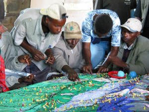
WParticipatory 3D modelling (P3DM) is a community-based mapping method which integrates local spatial knowledge with data on elevation of the land and depth of the sea to produce stand-alone, scaled and geo-referenced relief models. Essentially based on local spatial knowledge, land use and cover, and other features are depicted by informants on the model by the use of pushpins (points), yarns (lines) and paints (polygons). On completion, a scaled and geo-referenced grid is applied to facilitate data extraction or importation. Data depicted on the model are extracted, digitised and plotted. On completion of the exercise the model remains with the community.
 W
WPopulation Geography relates spatial variations in the distribution, composition, migration, and growth of populations to the terrain. Population geography involves demography in a geographical perspective. It focuses on the characteristics of population distributions that change in a spatial context. This often involves factors such as where populations are found and how the size and composition of these populations is regulated by the demographic processes of fertility, mortality, and migration. Contributions to population geography are cross-disciplinary because geographical epistemologies related to environment, place and space have been developed at various times. Related disciplines include geography, demography, sociology, and economics. Since its inception, population geography has taken at least three distinct but related forms, the most recent of which appears increasingly integrated with human geography in general. The earliest and most enduring form of population geography emerged in the 1950s, as part of spatial science. Pioneered by Glenn Trewartha, Wilbur Zelinsky, William A. V. Clark, and others in the United States, as well as Jacqueline Beujeau-Garnier and Pierre George in France, it focused on the systematic study of the distribution of population as a whole and the spatial variation in population characteristics such as fertility and mortality. Population geography defined itself as the systematic study of:the simple description of the location of population numbers and characteristics the explanation of the spatial configuration of these numbers and characteristics the geographic analysis of population phenomena.
 W
WPsychogeography is an exploration of urban environments that emphasizes playfulness and "drifting". It has links to the Lettrist and Situationist Internationals, revolutionary groups influenced by Marxist and anarchist theory, and the attitudes and methods of Dadaists and Surrealists. In 1955, Guy Debord defined psychogeography as "the study of the precise laws and specific effects of the geographical environment, consciously organized or not, on the emotions and behavior of individuals." As a practice and theory, psychogeography has influenced a broad set of cultural actors, including artists, activists and academics.
 W
WRugby league is a full contact football code and spectator sport played in various countries around the world and governed by the Rugby League International Federation. As of 2010 there are currently 27 nations fielding domestic leagues that meet the World Cup eligibility requirements. Further to this there are over 30 others that are playing at an emerging level status at varying degrees of international competition and are in the process of developing the game in their nations. The global player pool is estimated to be in the millions.
 W
WSettlement geography is a branch of human geography that investigates the earth's surface's part settled by humans. According to the United Nations' Vancouver Declaration on Human Settlements (1976), "human settlements means the totality of the human community – whether city, town or village – with all the social, material, organizational, spiritual and cultural elements that sustain it."
 W
WSub-replacement fertility is a total fertility rate (TFR) that leads to each new generation being less populous than the older, previous one in a given area. The United Nations Population Division defines sub-replacement fertility as any rate below approximately 2.1 children born per woman of childbearing age, but the threshold can be as high as 3.4 in some developing countries because of higher mortality rates. Taken globally, the total fertility rate at replacement was 2.33 children per woman in 2003. This can be "translated" as 2 children per woman to replace the parents, plus a "third of a child" to make up for the higher probability of boys born and mortality prior to the end of a person's fertile life. In 2020, the average global fertility rate is around 2.4 children born per woman.
 W
WThis is a list of articles about swimming in each country around the world. Most countries have two national championships per year, one in long course and one in short course. Some countries also have a national team championship.
 W
W W
WTourism geography is the study of travel and tourism, as an industry and as a social and cultural activity. Tourism geography covers a wide range of interests including the environmental impact of tourism, the geographies of tourism and leisure economies, answering tourism industry and management concerns and the sociology of tourism and locations of tourism.
 W
WTransport geography, also transportation geography, is a branch of geography that investigates the movement and connections between people, goods and information on the Earth's surface.
 W
WTravel behavior is the study of what people do over space, and how people use transport.
 W
WTropical geography refers to the study of places and people in the tropics. When it first emerged as a discipline, tropical geography was closely associated with imperialism and colonial expansion of the European empires as contributing scholars tended to portray the tropical places as "primitive" and people "uncivilised" and "inferior". A wide range of subjects has been discussed within the sub-field during late 18th to early 20th century including zoology, climatology, geomorphology, economics and cultural studies.
 W
WThe list of uninhabited regions includes a number of places around the globe. The list changes year over year as human beings migrate into formerly uninhabited regions, or migrate out of formerly inhabited regions.
 W
WUrban sprawl, or suburban sprawl, is the unrestricted growth in many urban areas of housing, commercial development, and roads over large expanses of land, with little concern for urban planning. In addition to describing a particular form of urbanization, the term also relates to the social and environmental consequences associated with this development. Since the advent of the industrial era, sprawl has entailed no direct disadvantages, such as the loss of protection from medieval city walls. However, its disadvantages and costs include increased travel time, transport costs, pollution, and destruction of countryside. The cost of building the infrastructure needed for new developments is hardly ever recouped through property taxes, amounting to a huge subsidy for the developers and new residents at the expense of existing property taxpayers. In Continental Europe, the term peri-urbanisation is often used to denote similar dynamics and phenomena, but the term urban sprawl is currently being used by the European Environment Agency. There is widespread disagreement about what constitutes sprawl and how to quantify it. For example, some commentators measure sprawl only with the average number of residential units per acre in a given area, but others associate it with decentralization, discontinuity, segregation of uses, and so forth.
 W
WThe Vienna Institute of Demography (VID) is a research institute of the division for humanities and social sciences within the Austrian Academy of Sciences (ÖAW) and part of the three "pillar institutions" of the Wittgenstein Centre for Demography and Global Human Capital.
 W
WGeography and wealth have long been perceived as correlated attributes of nations. Scholars such as Jeffrey D. Sachs argue that geography has a key role in the development of a nation's economic growth. For instance, nations that reside along coastal regions, or those who have access to a nearby water source, are more plentiful and able to trade with neighboring nations. In addition, countries that have a tropical climate face a significant amount of difficulties such as disease, intense weather patterns, and lower agricultural productivity. The correlation between geography and a nation's wealth can be observed by examining a country's GDP per capita, which takes into account a nation's economic output and population. The continents along the equator, Africa. Even within Africa this effect can be seen, as the nations farthest from the equator are wealthier. In Africa, the wealthiest nations are the three on the southern tip of the continent, South Africa, Botswana, and Namibia, and the countries of North Africa. Similarly, in South America, Argentina, Southern Brazil, Chile, and Uruguay have long been the wealthiest. Within Asia, Indonesia, located on the equator, is among the poorest. Within Central Asia, Kazakhstan is wealthier than other former Soviet Republics which border it to the south, like Uzbekistan. The wealthiest nations of the world with the highest standard of living tend to be those at the northern extreme of areas open to human habitation—including Northern Europe, the United States, and Canada. Within prosperous nations, wealth often increases with distance from the equator; for example, the Northeast United States has long been wealthier than its southern counterpart and northern Italy wealthier than southern regions of the country.