 W
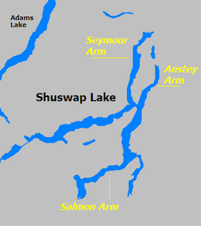
WIn geography, an arm is a narrow extension, inlet, or smaller reach, of water flowing out from a much larger body of water, such as an ocean, a sea, or a lake. Although different geographically, a sound or bay may also be called an arm.
 W
WA baïne is a pool of water of a few dozen to several hundreds of metres length parallel to the beach, and directly connected to the sea. These are spaced every 300 to 400 metres and formed under the influence of waves and the tide. The name baïne is typical for the Aquitaine coast of France found in the departements of Gironde, Charente-Maritime and Landes, but it occurs on beaches all around the world.
 W
WA breachway is the shore along a channel, or the whole area around where a channel meets the ocean. The Rhode Island coastline has many breachways on its map. Today's permanent breachways have rock jetties that line the sides of the channel to protect against erosion or closing of the waterway. The water channels usually lead to salt water ponds.
 W
WIn Scottish geography, a Carse is an area of fertile, low-lying land occupying certain Scottish river valleys, such as that of the River Forth.
 W
WA chapada is a plateau found in the Brazilian Highlands. The chapadas, which are usually described as mountain ranges, are capped by horizontal strata of sandstone. They show the original surface, which has been worn away by the rivers, leaving here and there broad flat-topped ridges between river basins and narrower ranges of hills between river courses. From the valleys their rugged, deeply indented escarpments, stretching away to the horizon, they have the appearance of a continuous chain of mountains.
 W
WA coastal plain is flat, low-lying land adjacent to a sea coast. Some of the largest coastal plains are in Alaska and the southeastern United States. The Gulf Coastal Plain of North America extends northwards from the Gulf of Mexico along the Lower Mississippi River to the Ohio River, which is a distance of about 981 miles (1,579 km).
 W
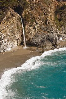
WA coastal waterfall is a waterfall that plunges directly into the sea. Another common name for this feature is a tidefall.
 W
WA cove is a small type of bay or coastal inlet. Coves usually have narrow, restricted entrances, are often circular or oval, and are often situated within a larger bay. Small, narrow, sheltered bays, inlets, creeks, or recesses in a coast are often considered coves.
 W
WA crag is a rocky hill or mountain, generally isolated from other high ground.
 W
WA discordant coastline occurs where bands of different rock type run perpendicular to the coast.
 W
WIn geography, a dry point is an area of firm or flood-free ground in an area of wetland, marsh or flood plains. The term typically applies to settlements, and dry point settlements were common in history.
 W
WA dry valley may develop on many kinds of permeable rock, such as limestone and chalk, or sandy terrains that do not regularly sustain surface water flow. Such valleys do not hold surface water because it sinks into the permeable bedrock.
 W
WTraditionally in geomorphology, a flatiron is a steeply sloping triangular landform created by the differential erosion of a steeply dipping, erosion-resistant layer of rock overlying softer strata. Flatirons have wide bases that form the base of a steep, triangular facet that narrows upward into a point at its summit. The dissection of a hogback by regularly spaced streams often resulted in the formation of a series of flatirons along the strike of the rock layer that formed the hogback. As noted in some, but not all definitions, a number of flatirons are perched upon the slope of a larger mountain with the rock layer forming the flatiron inclined in the same direction as, but often at a steeper angle than the associated mountain slope. The name flatiron refers their resemblance to an upended, household flatiron.
 W
WA flood-meadow is an area of grassland or pasture beside a river, subject to seasonal flooding. Flood-meadows are distinct from water-meadows in that the latter are artificially created and maintained, with flooding controlled on a seasonal and even daily basis.
 W
WA glen is a valley, typically one that is long and bounded by gently sloped concave sides, unlike a ravine, which is deep and bounded by steep slopes. Whittow defines it as a "Scottish term for a deep valley in the Highlands" that is "narrower than a strath". The word is Goidelic in origin: gleann in Irish and Scottish Gaelic, glion in Manx. The designation "glen" also occurs often in place names.
 W
WA guelta is a pocket of water that forms in drainage canals or wadis in the Sahara. The size and duration will depend on the location and conditions. It may last year-round through the dry season if fed by a source such as a spring. When a river (wadi) dries up, there may be pockets of water remaining along its course. In Western Sahara, gueltas correspond to oases.
 W
WIn xeric lands, a gulch is a deep V-shaped valley formed by erosion. It may contain a small stream or dry creek bed and is usually larger in size than a gully. Sudden intense rainfall upstream may produce flash floods in the bed of the gulch.
 W
WA Haufendorf is an enclosed village with irregular plots of land and farms of greatly differing scale, usually surrounded by a stockade fence. They are typically found in Germany, Austria and Switzerland, whence the name. Haufendörfer (pl.) differ from most other types of village in that they are irregularly laid out. A large number of Haufendörfer emerged in connexion with the medieval open field system (Gewanneflur), where each farmer farmed strips of different fields and the location of these field strips continually changed. The district (Gemarkung) was divided into the village core (Dorfkern), field system (Ackerflur) and common pasture (Allmende).
 W
WHigh country is a New Zealand term for the elevated pastoral land of the South Island and - to a lesser extent - North Island. This terrain, which can be compared loosely with the outback of Australia, high veldt of South Africa and pampas of Argentina, lies in the rain shadow of the country's mountain ranges and tends to be extensively farmed land with a continental climate consisting of low rainfall, cold winters and hot summers. Livestock farmed in these regions include sheep and - increasingly - deer and alpaca, and a major ground-covering plant of the area is tussock.
 W
WA high valley or high-level valley is a valley in the upper third of a mountain range. More loosely it can refer to any mountain valley.
 W
WAn ice piedmont consists of "Ice covering a coastal strip of low-lying land backed by mountains."
 W
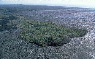
WA kīpuka is an area of land surrounded by one or more younger lava flows. A kīpuka forms when lava flows on either side of a hill, ridge, or older lava dome as it moves downslope or spreads from its source. Older and more weathered than their surroundings, kīpukas often appear to be like islands within a sea of lava flows. They are often covered with soil and late ecological successional vegetation that provide visual contrast as well as habitat for animals in an otherwise inhospitable environment. In volcanic landscapes, kīpukas play an important role as biological reservoirs or refugia for plants and animals, from which the covered land can be recolonized.
 W
WMagna Britannia, being a concise topographical account of the several counties of Great Britain was a topographical and historical survey published by the antiquarians Daniel Lysons and his brother Samuel Lysons in several volumes between 1806 and 1822. It covers the counties of Bedfordshire, Berkshire, Buckinghamshire, Cambridgeshire, Cheshire, Cornwall, Cumberland, Derbyshire, and Devon. The work was curtailed in 1819 on Samuel Lysons' death.
 W
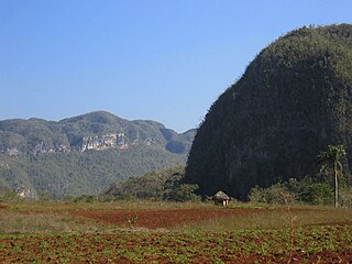
WA mogote is a generally-isolated steep-sided residual hill composed of either limestone, marble, or dolomite. Mogotes are surrounded by nearly flat alluvial plains. The hills typically have a rounded, tower-like form. Several mogotes along a ridge are called pepinos.
 W
WMoranbong or Moran Hill forms a park located in central Pyongyang, the capital of North Korea. Its 312-foot (95 m) summit is the location of the Pyongyang TV Tower.
 W
WNai Gaj is an ephemeral river in Dadu District of Sindh, Pakistan. The Government of Pakistan build the Nai Gaj Dam on its course. Nai Gaj drains part of the Kirthar Mountains, and flows from Balochistan province towards Sindh. It ends at Lake Manchar after flowing through the arid areas of Kachho in Dadu District.
 W
WA narrows or narrow, is a restricted land or water passage. Most commonly a narrows is a strait, though it can also be a water gap.
 W
WOpen terrain, open country or open ground is terrain which is mostly flat and free of obstructions such as trees and buildings. Examples include farmland, grassland and specially cleared areas such as an airport.
 W
WPalustrine wetlands include any inland wetland that contains ocean-derived salts in concentrations of less than 0.5 parts per thousand, and is non-tidal. The word palustrine comes from the Latin word palus or marsh. Wetlands within this category include inland marshes and swamps as well as bogs, fens, tundra and floodplains.
 W
WPantaron Mountain Range, also called the Central Cordillera of Mindanao, Philippines is a mountain range straddling across the provinces of Misamis Oriental, Bukidnon, Agusan del Norte, Agusan del Sur, Davao del Norte and Davao del Sur. The range contains one of the last remaining old growth or primary forest blocks in Mindanao. Major rivers in the island also has their headwaters in the mountain range including Mindanao River, Pulangi River, Davao River, Tagoloan River and major tributaries of Agusan River.
 W
WA perennial stream or perennial river is a stream or river (channel) which has constant stream throughout the year through parts of its stream bed during years of normal rainfall. In the absence of irregular, prolonged, or extreme drought, a perennial stream is a watercourse, or segment, element, or emerging body of water which continually delivers groundwater. For example, an artificial disruption of stream, variability in flow or stream selection associated with the activity in hydropower installations, shall not affect the measurement. Perennial streams do not consist of stagnant water for the wetlands, reservoirs, and ponds that occur all the period. All other streams, or portions thereof, should be considered seasonal rivers or lakes. The stream can cycle from broken to perpetual through multiple iterations, to intermittent through its mechanism.
 W
WA pillar is a landform, either of rock or earth, defined by the USGS as: "Vertical, standing, often spire-shaped, natural rock formation ." Some examples of rock pillars are Chambers Pillar, Katskhi pillar, Pompeys Pillar, and Pillar Rock.
 W
WA pinnacle, tower, spire, needle or natural tower in geology is an individual column of rock, isolated from other rocks or groups of rocks, in the shape of a vertical shaft or spire.
 W
WA pocket beach is usually a small beach that is isolated between two headlands. There is typically very little or no exchange of sediment between the pocket beach and adjacent shorelines.
 W
WIce deserts are the regions of the Earth that fall under an ice cap climate. Despite rainfall totals low enough to normally classify as a desert, polar deserts are distinguished from true deserts by low annual temperatures and evapotranspiration. Most polar deserts are covered in ice sheets, ice fields, or ice caps.
 W
WPresque-isle is a geographical term denoting a piece of land which is closer to being an island than most peninsulas because of its being joined to the mainland by an extremely narrow neck of land.
 W
WA ravine is a landform that is narrower than a canyon and is often the product of streambank erosion. Ravines are typically classified as larger in scale than gullies, although smaller than valleys.
 W
WA rincón is a grass meadow. The term is in wide use in English in the southwest United States, where it refers specifically to a sloping meadow on the south facing upper slopes of a forested mountain. These characteristic high meadows are formed by the repeated freezing and thawing of snow accumulations on south facing slopes, creating a habitat not conducive to forest. They are further maintained by a high frequency of low-intensity wildfire. A notable example of a wildfire begun in a rincon, with catastrophic consequences, was the 2000 Cerro Grande Fire in New Mexico, United States.
 W
WA river fork is where a river divides into two clearly distinct parts.
 W
WA rock shelter is a shallow cave-like opening at the base of a bluff or cliff. In contrast to solutional caves (karst), which are often many miles long, rock shelters are almost always modest in size and extent.
 W
WA sand island is an island that is largely made of sand. The largest sand island in the world is Fraser Island. Other examples of large sand islands are Moreton, North Stradbroke and Bribie Islands which lie south of Fraser Island off the east coast of Australia.
 W
WA spur is a lateral ridge or tongue of land descending from a hill, mountain or main crest of a ridge. It can also be defined as another hill or mountain range which projects in a lateral direction from a main hill or mountain range.
 W
WA steephead valley, steephead or blind valley is a deep, narrow, flat bottomed valley with an abrupt ending. Such closed valleys may arise in limestone or karst landscapes, where a layer of permeable rock lies above an impermeable substrate such as marl. Water flowing through a steephead valley leaves via one or more ponors or sinkholes.
 W
WA stone stripe, also called a lava stringer, is an elongated concentration of mostly talus-like basalt rock found along a hillside or the base of a cliff. Many stringers occur without cliffs. A stringer is identified by its lack of vegetative cover. They typically occur in north central Oregon and develop at 900 to 1,100 meter elevations. Lengths can range from only a few meters to over 150 meters, and widths measure from .3 to 3 meters. Depths of the stringers range from 20-65 centimeters.
 W
WA strath is a large valley, typically a river valley that is wide and shallow.
 W
WA string bog or strong mire is a bog consisting of slightly elevated ridges and islands, with woody plants, alternating with flat, wet sedge mat areas. String bogs occur on slightly sloping surfaces, with the ridges at right angles to the direction of water flow. They are an example of patterned vegetation.
 W
WA submerged continent or sunken continent is a region of continental crust, extensive in size but mainly undersea. The terminology is used by some paleogeologists and geographers in reference to some landmasses.
 W
WSubmergent coastlines are stretches along the coast that have been inundated by the sea by a relative rise in sea levels from either isostacy or eustacy.
 W
WA table or tableland is a butte, flank of a mountain, or mountain, that has a flat top.
 W
WTill plains are an extensive flat plain of glacial till that forms when a sheet of ice becomes detached from the main body of a glacier and melts in place, depositing the sediments it carried. Ground moraines are formed with melts out of the glacier in irregular heaps, forming rolling hills. Till plains are common in areas such as the Midwestern United States, due to multiple glaciation events that occurred in the Holocene epoch. During this period, the Laurentide Ice Sheet advanced and retreated over roughly a 60,000 year period. Till plains created by the Wisconsin glaciation cover much of the Midwest, including North Dakota, South Dakota, Indiana, Minnesota, Wisconsin, Iowa, Illinois, and northern Ohio.
 W
WA topographic profile or topographic cut is a representation of the relief of the terrain that is obtained by cutting transversely the lines of a topographic map. Each contour line can be defined as a closed line joining relief points at equal height above sea level. It is usually drawn on the same horizontal scale as the map, but the use of an exaggerated vertical scale is advisable to underline the elements of the relief. This can vary according to the slope and amplitude of the terrestrial relief, but is usually three to five times the horizontal scale.
 W
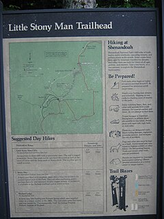
WA trailhead is the point at which a trail begins, where the trail is often intended for hiking, biking, horseback riding, or off-road vehicles. Modern trailheads often contain rest rooms, maps, sign posts and distribution centers for informational brochures about the trail and its features, and parking areas for vehicles and trailers. The United States access board states "A trailhead is defined as an outdoor space that is designated by an entity responsible for administering or maintaining a trail to serve as an access point to the trail."
 W
WA truncated spur is a spur, which is a ridge that descends towards a valley floor or coastline from a higher elevation, that ends in an inverted-V face and was produced by the erosional truncation of the spur by the action of either streams, waves, or glaciers. Truncated spurs can be found within mountain ranges, along the walls of river valleys, or along coastlines.
 W
WAn underground lake or subterranean lake is a lake under the surface of the Earth. Such lakes may be associated with caves, aquifers, or springs. They are typically very low in salinity.
 W
WA volcanic desert is an area devoid of vegetation because of volcanic activity. Usually the term is applied to larger areas such as the Highlands of Iceland, the Rangipo Desert in New Zealand or Cordón Caulle in Chile. Occasionally the term is used for relatively small regions such as the Kaʻū Desert on the island of Hawai'i. Volcanic deserts may have enough precipitation to sustain vegetation, but due to repeated covering of tephra and acid rain after eruptions and high percolation and infiltration rates of water, vegetation is scarce. In addition to this volcanic desert shows often poor or little soil formation due to slow chemical weathering caused by cold climate or coarse tephra. The Plaine des Sables, on Réunion, is close to the Commerson Crater, a place which holds several world records of rainfall.
 W
WA watercourse is the channel that a flowing body of water follows.
 W
WWaterwolf, or Water-wolf is a Dutch word that comes from the Netherlands, which refers to the tendency of lakes in low lying peaty land, sometimes previously worn-down by men digging peat for fuel, to enlarge or expand by flooding, thus eroding the lake shores, and potentially causing harm to infrastructure or death. The term waterwolf is an example of zoomorphism, in which a non-living thing is given traits or characteristics of an animal. The traits of a wolf most commonly given to lakes include “something to be feared”, “quick and relentless”,” an enemy of man”.
 W
WA Zungenbecken, also called a tongue basin or tongue-basin, is part of a succession of ice age geological landforms, known as a glacial series. It is a hollow that is left behind by the ice mass, as the snout of the glacier recedes, which initially fills with meltwater, forming a proglacial lake, and later may be filled with surface water from streams or precipitation. When the glacier has more fully retreated this produces a finger lake or glacial piedmont lake. The term Zungenbecken is of German origin, but used in English language sources.