 W
WAkersgata is a street in Oslo, Norway. It contains a number of important buildings such as the Parliament of Norway Building, several government buildings in the Regjeringskvartalet, the Trefoldighetskirken, and the Centralteatret.
 W
WThe Bergen Program for Transport, Urban Development and the Environment is a political agreement for financing road and light rail investments in Bergen, Norway, from 2002 to 2015. The projects cost 5.3 billion kr, and will be partially financed through state grants and partially through a toll ring.
 W
WBispelokket was a Norwegian three-level stack interchange roundabout in Bjørvika, Oslo. European Route E18 and Norwegian National Road 162 jointed at this point, which also served as the official traffical centre of the city. The new roundabout at Postgirobygget is from October 31, 2011, the new traffical centre of Oslo.
 W
WBogstadveien is a street in the district of Frogner in Oslo, Norway. It is considered a central business district and features many of the city's wide range of exclusive shops as well as entertainment, hotels and restaurants. The road is known for the frequent Farmer's Markets on weekends as well as its biannual car-free shopping events.
 W
WCounty Road 181 is a two-lane highway which runs between Boksrud in Eidsvoll and Sagstua in Nord-Odal, Norway. The road is 26.4 kilometers (16.4 mi) long, of which 16.9 kilometers (10.5 mi) is in Akershus, and 9.5 kilometers (5.9 mi) km in Hedmark. Formerly Norwegian National Road 181, it was reclassified on 1 January 2010 from a national road to a county road, as part of a transfer of most national roads to the county municipalities.
 W
WEuropean route E12 is a road that is part of the International E-road network. It begins in Mo i Rana, Norway, transverses Sweden and ends in Helsinki, Finland, with a ferry line between Sweden and Finland. The part within Finland is Finnish national highway 3. The road is about 910 km (570 mi) in length.
 W
WEuropean route E14 is a part of the International E-road network. It begins in Trondheim, Norway, and ends in Sundsvall, Sweden. The road is 449 kilometres (279 mi) long.
 W
WEuropean route E69 is an E-road between Olderfjord and North Cape in northern Norway. The road is 129 km (80 mi) long. It contains five tunnels, totalling 15.5 km (9.6 mi). The longest, the North Cape Tunnel, is 6.9 km (4.3 mi) long and reaches 212 m (696 ft) below sea level.
 W
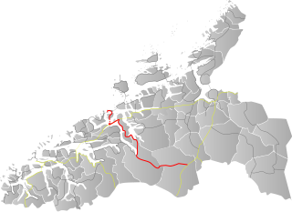
WEuropean route E 136 is a European highway located entirely in Møre og Romsdal and Innlandet counties in Norway. The highway begins in the town of Ålesund in Møre og Romsdal county on the west coast of Norway and it goes east up through the Romsdalen valley and crossing into the upper Gudbrandsdalen Valley to end at the village of Dombås in Oppland county.
 W
WThe Filefjell Kongevegen is the name of the old trail over Filefjell, the mountainous area between Lærdal/Borgund, and Valdres in Norway. It is the historical main route linking Western Norway and Eastern Norway.
 W
WCounty Road 171 is a 30.4 kilometres (18.9 mi) county road that runs between Gran in Sørum and Finstadbråten, Aursmoen in Aurskog-Høland, Norway.
 W
WJotunheimvegen is a 45 kilometres (28 mi) long toll road through Jotunheimen in Innlandet county in Norway. It goes from Skåbu to Slangen and the lakes Sandvatnet en Vinstri until the road RV 51. Nearby is the Peer Gynt tourist road to Lillehammer. Nearby is also the national park Ormtjernkampen.
 W
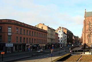
WKarl Johans gate is the main street of the city of Oslo, Norway. The street was named in honor of King Charles III John, who was also King of Sweden as Charles XIV John.
 W
WNorwegian National Road 3 is a Norwegian national road that is the main route through the Østerdalen district. It has been dubbed Den grønne Snarvei 'the green shortcut' by the Hedmark county municipality. The route runs south from European Route E6 at Ulsberg in the municipality of Rennebu in Trøndelag county, via Tynset and Elverum, to Stange in Hedmark county, where it rejoins European Route E6. The route was 291.3 kilometers (181.0 mi) long, of which 277.9 kilometers (172.7 mi) are in Hedmark county and 13.4 kilometers (8.3 mi) are in Trøndelag county.
 W
WRiksvei 4 (Rv4) is a national road which is the main route north from Oslo, Norway. The road runs through Nittedal, Hadeland and Toten to the lake of Mjøsa.
 W
WNorwegian National Road 7 is a national road in Norway which runs from the town of Hønefoss in Viken county to the village of Granvin in Vestland county. The route is 387.6 kilometres (240.8 mi) long and runs east–west through Viken and Vestland counties over the vast Hardangervidda plateau.
 W
WRiksvei 22 (Rv22) runs between Hvam in Skedsmo and Øra in Fredrikstad. The road is 117.3 km, of which 35.8 km is in Akershus and 81.5 km in Østfold.
 W
WRiksvei 120 (Rv120) runs between Skedsmovollen and Mosesvingen, Skedsmo.
 W
WRiksvei 163 (Rv163) runs between Skogskrysset in Lørenskog and Økern in Oslo. The road is 11 km, of which 1.2 km are in Akershus and 9.8 km in Oslo.
 W
WNorwegian National Road 168 is a major route between Bærum and Oslo, Norway.
 W
WRiksvei 159 (Rv159) is a four-laned motorway between Karihaugen in Oslo and Lillestrøm in Skedsmo. The road is 11.4 km, of which 1.7 km is in Oslo and 9.7 km is in Akershus.
 W
WA Norwegian county road is a highway in Norway that is owned and maintained by the local county municipality. Some of the roads have road signs. The signs are white with black numbers.
 W
WCounty Road 17, also known as the Coastal Highway, is a Norwegian highway that runs from the town of Bodø in Nordland county to the town of Steinkjer in Trøndelag county. It is 630 kilometres (390 mi) long and includes six ferry crossings. The road runs along the coast of Nordland and Trøndelag counties through 28 different municipalities. This road is a much more scenic, albeit longer and more time-consuming, route than the inland European Route E6 highway.
 W
WCounty Road 51 is a 168.2-kilometer-long (104.5 mi) highway which runs north–south between Vågå and Gol, Norway. Part of the road runs concurrently with E16, between Leira and Fagernes. The 37-kilometer (23 mi) section across Valdresflye is designated a National Tourist Route. This section is closed in the winter. Prior to 2010, the road was known as National Road 51.
 W
WCounty Road 55 is a 248.1-kilometer-long (154.2 mi) highway which runs between the municipalities of Lom and Høyanger in Norway. The 108-kilometer (67 mi) section across Sognefjellet, known as Sognefjellsvegen, is designated a National Tourist Route. Also a short section at Balestrand is a National Tourist Route. The road reaches the highest elevation on the public road network in Norway, 1,434 meters (4,705 ft), and it is closed every winter.
 W
WCounty Road 82 is a road in Nordland county, Norway. It runs between the village of Fiskebøl and the town of Andenes. The road runs through the municipalities of Hadsel, Sortland, and Andøy. At Fiskebøl, the road intersects with the European route E10 highway before crossing the Hadselfjorden on the Fiskebøl–Melbu Ferry. Bridges on the road include Andøy Bridge, Sortland Bridge, Hadsel Bridge, and Børøy Bridge. Two sections are designated as part of two National Tourist Routes in Norway: the section from the intersection with E10 to Fiskebøl is part of Lofoten National Tourist Route, and the section through Andenes is part of Andenes National Tourist Route. During summer, the Andenes–Gryllefjord Ferry connects to County Road 86 at Gryllefjord on the island of Senja. Before 1 January 2010, the road was called National Road 82, but due to reforms that went into effect on that day, the county took over the ownership and maintenance of the road.
 W
WNorwegian County Road 174 is 11.8 kilometers (7.3 mi) long and runs between Nordby and Dalstua in Ullensaker, Norway. Prior to 1 January 2010, it was known as National Road 174.
WCounty Road 178 runs between Eltonåsen in Nannestad and Jessheim in Ullensaker, Norway. The road is 11.1 kilometers (6.9 mi) long. Prior to 1 January 2010, the road was a national road, but after reclassification, it became a county road.
 W
WCounty Road 258, also known as Gamle Strynefjellsvegen, is a 27-kilometre (17 mi) long road that runs through the Videdalen valley between the village of Grotli in Skjåk Municipality and the village of Ospeli in Stryn Municipality. The road opened in 1894, but was replaced by National Road 15 in 1977 as the main route between the Nordfjord region and Eastern Norway. The road is closed from October to June and is designated one of eighteen National Tourist Routes in Norway. The Tystigbreen glacier lies just south of the road. The eastern part of road has a gravel surface as a heritage road. The road is very narrow, only about 3.5–4.5 metres (11–15 ft). Starting in 2019, there is a more strict vehicle length limit of 8 metres (26 ft) and a weight limit of 8 tonnes per axle, due to maintenance issues, which means that tourist buses are not permitted on the road anymore.
 W
WCounty Road 300 or Ringveg nord is a bypass road running north of Tønsberg, Norway. It is 7.0 kilometers (4.3 mi) long and connects the eastern part of Tønsberg, via the Frodeåsen Tunnel to E18. The road opened on 13 March 2008.
 W
WNorwegian County Road 404 is a Norwegian county road in Agder county, Norway. The 27.83-kilometre (17.29 mi) long road runs between the village of Frivoll in Grimstad municipality in the southeast and the village of Søre Herefoss in Birkenes municipality at the south end of the Herefossfjorden. The road connects to the Norwegian National Road 41 at Søre Herefoss and it connects to the European route E18 highway at Frivoll. The road passes between the two lakes Syndle and Rore in rural Grimstad, just northeast of the village of Roresand. Prior to a 2010 government reform, the road was classified as a Norwegian national road.
 W
WNorwegian County Road 405 (Fv405) is a Norwegian county road which runs between from the village of Engesland in Birkenes municipality in Agder county in the north to the junction with the Norwegian National Road 9 in the village of Mosby in Kristiansand municipality in the south. The road is 54.56 kilometres (33.90 mi) long. Prior to a 2010 government reform, the road was classified as a Norwegian national road.
 W
WNorwegian County Road 406 is a Norwegian county road in Birkenes municipality in Agder county, Norway. The 18.1-kilometre (11.2 mi) long road runs between the village of Sennumstad on the Tovdalselva river to the village of Stemlona. The road connects to the Norwegian County Road 405 at Stemlona and it connects to the Norwegian National Road 41 at its other end at Sennumstad. The road runs through a fairly rural area in Birkenes. The Sørlandsbanen railway line crosses over the road at Fidje.
 W
WNorwegian county road 408 is a 12.2-kilometre (7.6 mi) long Norwegian county road which runs between the villages of Blakstad in Froland municipality and Rykene in Arendal municipality. The road roughly follows the river Nidelva the whole way. Prior to 2010, this was a Norwegian national road, but in the transportation reforms that year, the road was transferred to county control.
 W
WNorwegian county road 410 is a Norwegian county road which runs for 33.8 kilometres (21.0 mi) between the Harebakken mall in Arendal municipality and Rødmyr in Tvedestrand municipality. Prior to 2010, this was a Norwegian national road, but in the transportation reforms that year, the road was transferred to county control.
 W
WNorwegian county road 411 (Fv411) is a Norwegian county road in Agder county, Norway. The 27.8-kilometre (17.3 mi) long road runs between Tvedestrand and Risør municipalities. The western end of the road starts at the junction of Norwegian County Road 410 in the town of Tvedestrand in Tvedestrand municipality. It then heads along the coastline until it reaches the junction with Norwegian County Road 416 at Bossvika in Risør municipality.
 W
WNorwegian county road 412 (Fv412) is a Norwegian county road in Åmli municipality in Agder county, Norway. The 4.59-kilometre (2.9 mi) long road runs between the Norwegian County Road 415 at the village of Hovde and Nelaug Station in the village of Nelaug.
 W
WNorwegian county road 413 (Fv413) is a Norwegian county road in Agder county, Norway. The 15-kilometre (9.3 mi) long road which runs between the village of Dølemo in Åmli municipality and just west of the village of Mykland in Froland municipality. The northern junction at Dølemo connects with the Norwegian National Road 41. Near the northern end of the road, the Norwegian County Road 272 which heads north into the Tovdal valley. The southern junction joins the Norwegian County Road 42 just west of the village of Mykland. The road runs mostly through a rural forested area during its entire length.
 W
WNorwegian county road 414 (Fv414) is a Norwegian county road in Agder county, Norway. The 12.1-kilometre (7.5 mi) long road runs between Ubergsmoen and Høl in Vegårshei municipality. The south end of the road begins at a junction with Norwegian County Road 415 at the Ekra farm in Ubergsmoen and heads north along the Hauglandselva river, through the village of Myra where the junction with Norwegian County Road 416 is located, past the Vegårshei Church, all the way to the north end of the road at the Høl farm. The road then turns into Norwegian County Road 91.
 W
WNorwegian county road 415 (Fv415) is a Norwegian county road in Agder county, Norway. The 37.3-kilometre (23.2 mi) long highway runs between the European route E18 highway at Fiane in Tvedestrand municipality and the Norwegian National Road 41 at Myråsen, just south of the village of Åmli in Åmli municipality. The Norwegian County Road 412 splits off from this road to connect to Nelaug and the Nelaug Station. The Norwegian County Road 414 connects to this road at Ubergsmoen and heads north into Vegårshei.
 W
WNorwegian county road 416 (Fv416) is a Norwegian county road in Agder county, Norway. The 29.2-kilometre (18.1 mi) road runs between the town of Risør in Risør municipality and the Norwegian County Road 414 in the village of Myra in Vegårshei municipality.
 W
WNorwegian county road 417 (Fv417) is a Norwegian county road in Agder county, Norway. The 16.5-kilometre (10.3 mi) long road begins at the Norwegian County Road 416 near the Bråten farm in Vegårshei municipality and it ends at the junction of the Norwegian County Road 418 and the European route E18 highway at the village of Sundebru in Gjerstad municipality. The Sørlandsbanen railway line crosses this road twice.
 W
WNorwegian county road 418 (Fv418) is a Norwegian county road in Agder county, Norway. The 20-kilometre (12 mi) long road runs between the junction of Norwegian County Road 416 at the Aspelund farm in Risør municipality and the junction with Norwegian County Road 71 at Egddalen in the village of Gjerstad in Gjerstad municipality. The route from Aspelund to Sundebru used to be part of the European route E18 highway.
 W
WNorwegian County Road 419 (Fv419) is a Norwegian county road which runs between the villages of Hannåsmoen and Klepp in Evje og Hornnes municipality in Agder county, Norway. The 1.8-kilometre (1.1 mi) long road includes a bridge over the river Otra. It is one of five bridges over the river Otra in the municipality. The western end of the road connects with the Norwegian National Road 9 which runs north-south into the Setesdalen valley.
 W
WCounty Road 542 is a 19.7 kilometers (12.2 mi) long county road in Vestland county, Norway. The road is located in Stord Municipality and Bømlo Municipality. It connects the islands of Bømlo to the island of Føyno in Stord via part of the Triangle Link. County Road 542 contains two mayor bridges, the Bømla Bridge and Spissøy Bridge.
 W
WCounty Road 562 is a county road in Vestland county, Norway. The 23.7-kilometre (14.7 mi) long road runs from the northern shore of the lake Storavatnet in the city of Bergen on the Bergen Peninsula, over the Askøy Bridge, and across the western part of the island of Askøy, ending at the village of Skråmestø.
 W
WCounty Road 663 is a two-lane highway which runs between Moen in Fræna and Mjølkestølen in Eide, in Møre og Romsdal, Norway. At both termini it has an intersection with County Road 64. Part of the road has been designated as one of eighteen National Tourist Routes in Norway.
 W
WNorwegian County Road 709 is a Norwegian county road which runs between the villages of Børsa and Hove in the municipality of Skaun in Trøndelag county, Norway. The 14.1-kilometre (8.8 mi) long road intersects with the European route E39 at its northern terminus. Prior to 1 January 2010, this road was a Norwegian national road; on that date the regional reform came into force, and the status of this road was downgraded from a national road to a county road.
 W
WNorwegian County Road 755 is a county road in Trøndelag county, Norway. The 91.2-kilometre (56.7 mi) road runs from the village of Røra in the municipality of Inderøy to the village of Vanvikan in Indre Fosen municipality. It was known as Norwegian National Road 755 before 2010 when control of the road was transferred from the national government to the county.
 W
WNorwegian County Road 774 is a 4.2-kilometre (2.6 mi) long county road in the municipality of Levanger in Trøndelag county, Norway. It begins at the junction with the European route E06 highway at the village of Mule. It then heads into and through parts of the town of Levanger. There, the road continues as the Levanger–Hokstad Ferry operated by Tide Sjø to the village of Hokstad on the island of Ytterøya. After the ferry, the road changes to Norwegian County Road 135.
 W
WCounty Road 889 is 85.3 kilometers (53.0 mi) long and runs between Smørfjord and Havøysund in Troms og Finnmark, Norway. The road runs through Porsanger, Kvalsund and Måsøy, and passes the small villages of Kokelv, Lillefjord, Latter, Slåtten, Snefjord, Krokelv and Bakfjord. At Smørfjord, the road branches from E69. It crosses to Havøysund across the Havøysund Bridge. The section from Kokelv to Havøysund is designated one of eighteen National Tourist Routes in Norway.
 W
WCounty Road 5096 is a 9.2 kilometers (5.7 mi) long county road in Eidfjord Municipality in Vestland county, Norway. The road heads northeast from the village of Eidfjord. Prior to 2020, the road was called County Road 103. It was changed in 2020 when Vestland county was created.
 W
WNorwegian County Road 5627 is a 48.6-kilometer (30.2 mi) long road which crosses the Aurlandsfjellet mountains. The route was replaced by the 24.51-kilometre (15.23 mi) long Lærdal Tunnel—the world's longest road tunnel. The barren mountain plateau offers views 600 m (2,000 ft) down on the Aurlandsfjord. It is designated a National Tourist Route in Norway.
 W
WNational Road 13 is a national road which runs from the town of Stavanger in Rogaland county to the village of Sogndalsfjøra in Vestland county. The route is 449.9 kilometers (279.6 mi) long and runs south–north through Rogaland and Vestland counties, following a more inland path than the European route E39 highway.
 W
WNational Road 70 is a 162.0-kilometre (100.7 mi) long national highway that runs from the town of Kristiansund in Kristiansund Municipality in Møre og Romsdal county and the village of Oppdal in Oppdal Municipality in Trøndelag county, Norway.
 W
WThe Peer Gynt Road is a 60-kilometre-long tourist mountain road, named for the folkloric character Peer Gynt. It is a toll road. It runs in the east of Norway in Innlandet county with views of Jotunheimen, along the villages Skeikampen, Fagerhøy, Gålå, Fefor and Dalseter.
 W
WPilestredet is a street in Oslo, Norway which begins in the city center and runs through the boroughs of St. Hanshaugen and Frogner.
 W
WNorwegian National Road 191 runs down Groruddalen in Oslo from north to south. The road runs between Trosterud in Alna and Veitvet in Grorud. The road is 1.7 km.
 W
WNorwegian National Road 150, also known as Ring 3 and formerly Store Ringvei is a beltway limited-access road which circumnavigates Oslo, Norway. It runs from Ryen, through the Sinsen Interchange to Lysaker in Bærum.
 W
WStegastein is a scenic overlook on Sogn og Fjordane County Road 243 in Norway. The 30-metre (98 ft) long and 4-metre (13 ft) wide platform of steel and laminated pine overlooks Aurlandsvangen and the Aurlandsfjord. This project is part of a national program of tourist routes commissioned by the Norwegian Highway Department.