 W
WAltarduken Glacier is a small glacier just east of The Altar at the head of Grautskala Cirque, in the Humboldt Mountains of Queen Maud Land, Antarctica. It was discovered and mapped from air photos by the Third German Antarctic Expedition, 1938–39, but was remapped by Norway from air photos and surveys by the Sixth Norwegian Antarctic Expedition, 1956–60, and named Altarduken in association with The Altar.
 W
WMount Andreyev is a mountain, 2,320 m, standing close southwest of Mount Dallmann where it forms part of the southwest wall of Brattebotnen Cirque, in the Orvin Mountains, Queen Maud Land. Probably first seen by the German Antarctic Expedition, 1938–39. Mapped from air photos and surveys by Norwegian Antarctic Expedition, 1956–60; remapped by Soviet Antarctic Expedition, 1960–61, and named after Soviet historical geographer A.I. Andreyev (1887—1959).
WAnuchin Glacier is a glacier draining southward to Lake Unter-See in the northern part of the Gruber Mountains, Queen Maud Land. It was discovered, and plotted from air photos, by the Third German Antarctic Expedition, 1938–39. It was mapped from air photos and from surveys by the Sixth Norwegian Antarctic Expedition, 1956–60, and remapped by the Soviet Antarctic Expedition, 1960–61, and named after Dmitry Nikolayevich Anuchin, Soviet geographer.
WAsimutbreen Glacier is a small, steep tributary glacier to Vangengeym Glacier, descending southeast and then northeast between Solhogdene Heights and Skuggekammen Ridge, in the eastern Gruber Mountains of the Wohlthat Mountains, Queen Maud Land. It was discovered and plotted from air photos by the Third German Antarctic Expedition, 1938–39, replotted from air photos and from surveys by the Sixth Norwegian Antarctic Expedition, 1956–60, and named Asimutbreen.
WAstrid Ridge is an undersea ridge on the continental margin of Dronning Maud Land, East Antarctica. It is present on the GEBCO 5th edition charts. The name was approved by the Advisory Committee for Undersea Features in June 1987.
WAustreskorve Glacier is a broad glacier in the Mühlig-Hofmann Mountains which drains north from a position just east of the head of Vestreskorve Glacier and passes along the east side of Breplogen Mountain. It was mapped and named from surveys and from air photos by the Sixth Norwegian Antarctic Expedition (1956–60).
 W
WBakewell Island is a small ice-covered island near Princess Astrid Coast and east of Lyddan Island in the south part of the Riiser-Larsen Ice Shelf. The island was discovered November 5, 1967, in the course of a U.S. Navy Squadron VXE-6 flight over the coast in LC-130 aircraft, and was plotted by the United States Geological Survey from air photos taken at that time. It was named by the Advisory Committee on Antarctic Names after William Lincoln Bakewell, the lone American on Ernest Shackleton's ill-fated 1914–16 expedition in the Endurance to this area; Bakewell reportedly represented himself as Canadian to gain acceptance for the voyage to Antarctica.
WBarkov Glacier is a glacier draining northeast between Mount Dallmann and the central part of the Shcherbakov Range, in the Orvin Mountains, Queen Maud Land. First photographed and roughly plotted by the Third German Antarctic Expedition, 1938–39, it was mapped from air photos and surveys by the Sixth Norwegian Antarctic Expedition, 1956–60, remapped by the Soviet Antarctic Expedition, 1960–61, and named after Soviet geographer A.S. Barkov.
WThe Drygalski Mountains are a group of scattered mountains and nunataks lying between the Filchner Mountains and the Kurze Mountains in the Orvin Mountains of Queen Maud Land. They were discovered by the Third German Antarctic Expedition (1938–1939), led by Captain Alfred Ritscher, and named for Professor Erich von Drygalski, the leader of the First German Antarctica Expedition of 1901–03. They were remapped from air photos and survey by the Sixth Norwegian Antarctic Expedition, 1956–60.
WEntuziasty Glacier is a broad outlet glacier of Queen Maud Land, flowing generally northward into the Lazarev Ice Shelf. It is nourished in its upper reaches by ice draining from the Hoel Mountains and the northeast end of the Wohlthat Mountains, and its tributaries include the Mushketov Glacier. The lower part of the glacier, particularly the relationship with the Mushketov Glacier, was first delineated by the Soviet Antarctic Expedition in 1961. They named it "Lednik Entuziastov".
 W
WFenriskjeften Mountain is a large bare rock mountain which in plan resembles a hairpin, forming the southern portion of the Drygalski Mountains in Queen Maud Land, Antarctica. It was plotted from air photos by the Third German Antarctic Expedition (1938–39), mapped from surveys and air photos by the Sixth Norwegian Antarctic Expedition (1956–60), and because of its shape named Fenriskjeften, after the wolf in Norse mythology.
WThe Filchner Mountains are a group of mountains 11 km (7 mi) southwest of the Drygalski Mountains, at the western end of the Orvin Mountains of Queen Maud Land, Antarctica. They were discovered by the Third German Antarctic Expedition (1938–1939), led by Capt. Alfred Ritscher, and named for Wilhelm Filchner, leader of the German expedition to the Weddell Sea area in 1911–12. They were remapped from air photos taken by the Sixth Norwegian Antarctic Expedition, 1958–59.
WFimbulheimen is a mountain range in Queen Maud Land, Antarctica. It stretches from Jutulstraumen by 1° west of Carsten Borchgrevink Ice at 18° east, about 200 km from the ice edge. Fimbulheimen is thus between Maudheim Plateau and Sør-Rondane.
 W
WThe Gruber Mountains are a small group of mountains consisting of a main massif and several rocky outliers, forming the northeast portion of the Wohlthat Mountains in Queen Maud Land, Antarctica. They were discovered and plotted from air photos by the Third German Antarctic Expedition (GerAE), 1938–39, under Alfred Ritscher. The mountains were remapped by the Sixth Norwegian Antarctic Expedition, 1956–60, who named them for Otto von Gruber, the German cartographer who compiled maps of this area from air photos taken by the GerAE. This feature is not to be confused with "Gruber-Berge," an unidentified toponym applied by the GerAE in northern the Mühlig-Hofmann Mountains.
WHåhellerskarvet, meaning "shark cave mountain" in Norwegian, is a 2,910 metres (9,550 ft) high partially ice-covered mountain between Austreskorve Glacier and Lunde Glacier in the Mühlig-Hofmann Mountains of Queen Maud Land, East Antarctica. Other nearby geographic features include Håhelleren Cove, indenting the north side of Håhellerskarvet, Håhelleregga Ridge, an irregular rock ridge just north of Håhellerskarvet, Håhellerbotnen Cirque, a large cirque on the east side of Håhelleregga Ridge, and Jøkulkyrkja, a broad, ice-topped mountain located east of Lunde Glacier. All of these geographic features were plotted from surveys and air photos by the Sixth Norwegian Antarctic Expedition (1956–60).
WHålisen Glacier is a cirque glacier between Halisstonga Peak and Halisrimen Peak in the Kurze Mountains of Queen Maud Land, Antarctica. It was mapped by Norwegian cartographers from surveys and air photos by the Sixth Norwegian Antarctic Expedition (1956–60) and named Hålisen.
WThe Hoel Mountains are a group of mountains including the Weyprecht Mountains and the Payer Mountains in Queen Maud Land, Antarctica. They were first photographed from the air and plotted by the Third German Antarctic Expedition (1938–39), mapped by Norwegian cartographers from surveys and air photos by the Sixth Norwegian Antarctic Expedition (1956–60) and named for Adolf Hoel, a Norwegian geologist and Arctic explorer, leader and member of many expeditions to Greenland and Spitsbergen since 1907.
 W
WHoltanna Peak is a peak, 2,650 metres (8,700 ft) high, whose eastern portion is occupied by a small cirque glacier, standing 1 nautical mile (2 km) north of the Mundlauga Crags in the eastern part of Fenriskjeften Mountain in Queen Maud Land, Antarctica. It was mapped from surveys and air photos by the Sixth Norwegian Antarctic Expedition (1956–60) and named Holtanna.
 W
WJøkulkyrkja Mountain, also known as Massiv Yakova Gakkelya, is a broad, ice-topped mountain with several radial rock spurs, standing east of Lunde Glacier in the Mühlig-Hofmann Mountains of Queen Maud Land, East Antarctica. At 3,148 metres (10,328 ft) elevation, it is the highest elevation in Queen Maud Land, and also the highest elevation within the claims of Norway. The mountain is located on the Princess Astrid Coast of the Norwegian Antarctic Territory. Håhellerskarvet, 2,910 metres (9,550 ft), is located to the southwest; the two peaks are separated by the 25-mile-long Lunde Glacier, which flows to the northwest.
 W
WThe Kurze Mountains are a range of mainly bare rock peaks, ridges and mountains about 20 nautical miles (40 km) long and 6 nautical miles (11 km) wide in the Orvin Mountains of Queen Maud Land, Antarctica. The feature stands between the Drygalski Mountains on the west and the Gagarin Mountains and Conrad Mountains on the east.
WLangskavlen Glacier is a short, steep glacier flowing from the north side of Skavlhø Mountain in the Payer Mountains of Queen Maud Land, Antarctica. It was mapped by Norwegian cartographers from surveys and air photos by the Sixth Norwegian Antarctic Expedition (1956–60) and named Langskavlen.
WLunde Glacier is a glacier about 25 nautical miles (46 km) long flowing northwest between Håhellerskarvet and Jøkulkyrkja Mountain in the Mühlig-Hofmann Mountains of Queen Maud Land. It is located in the Princess Astrid Coast of the Norwegian Antarctic Territory.
WMendeleyev Glacier is a glacier, 10 nautical miles (19 km) long, draining northeast through the northern outcrops of the Payer Mountains, in Queen Maud Land, Antarctica. It was mapped from air photos and surveys by the Soviet Antarctic Expedition, 1960–61, and named after Russian chemist Dmitri Mendeleev, whose surname may also be transliterated as "Mendeleyev".
WMushketov Glacier is a large glacier trending northeastward, draining the area between the Wohlthat Mountains on the west and the Weyprecht, Payer and Lomonosov Mountains on the east, in Queen Maud Land. Discovered and plotted from air photos by German Antarctic Expedition, 1938–39. Replotted from air photos and surveys by Soviet Antarctic Expedition, 1958–59, and named after Ivan V. Mushketov (1850–1902), Russian geologist and geographer.
WNadezhdy Island is a bare rock island nearly 1.9 kilometres (1 nmi) long, lying just off the north-central side of Schirmacher Hills, Queen Maud Land. First photographed from the air by the German Antarctic Expedition, 1938–39. Mapped by the Soviet Antarctic Expedition in 1961 and named Ostrov Nadezhdy.
 W
WNeumayer-Station or Neumayer-Station II was a permanent German Antarctic research base on Atka Bay. It opened in 1992, replacing the old Georg-von-Neumayer-Station.
 W
WThe Nordenskiöld Base is a name sometimes used for the facilities shared by the Antarctic stations Wasa (Sweden) and Aboa (Finland).
 W
WNovolazarevskaya Station is a Russian, formerly Soviet, Antarctic research station. The station is located at Schirmacher Oasis, Queen Maud Land, 75 km from the Antarctic coast, from which it is separated by Lazarev Ice Shelf. It was opened on January 18, 1961 by the 6th Soviet Antarctic Expedition. The maximum summer population is 70.
WLake Ober-See is a permanently-frozen glacial meltwater lake lying between Sjøneset Spur and Mount Seekopf in the Gruber Mountains of Queen Maud Land, Antarctica. The lake was discovered by the German Antarctic Expedition under Alfred Ritscher, 1938–39.
 W
WOtter Plain is an ice plain between Sigurd Knolls on the north and the Muhlig-Hofmann and Drygalski Mountains on the south, in Queen Maud Land. Plotted from surveys and air photos by the Norwegian Antarctic Expedition (1956–60) and named after the Otter aircraft used by the expedition.
WParizhskaya Kommuna Glacier is a glacier, 8 nautical miles (15 km) long, draining northwest between Zwiesel Mountain and Grakammen Ridge to Humboldt Graben in the Petermann Ranges, Wohlthat Mountains. Discovered and plotted from air photos by German Antarctic Expedition, 1938–39. Mapped from air photos and surveys by Norwegian Antarctic Expedition, 1956–60; remapped by Soviet Antarctic Expedition, 1960–61, and named Lednik Parizhskoy Kommuny.
WThe Payer Mountains is a group of scattered mountains extending north-south for about 37 km (23 mi), standing 15 km (9 mi) east of the Weyprecht Mountains and forming the eastern half of the Hoel Mountains in central Queen Maud Land.
 W
WThe Petermann Ranges are a number of associated mountain ranges including the Östliche Petermann, Mittlere Petermann, Westliche Petermann, Südliche Petermann, and Pieck Ranges, located just east of the Humboldt Mountains in the central Wohlthat Mountains of Queen Maud Land.
WPodprudnoye Lake is a small lake lying just southeast of Prilednikovoye Lake in Schirmacher Hills, Queen Maud Land. It was mapped by the Soviet Antarctic Expedition in 1961 and named Ozero Podprudnoye.
WPrilednikovoye Lake is a lake 1.25 nautical miles (2.3 km) south-southwest of Tyuleniy Point in the Schirmacher Hills, situated at the edge of the continental ice sheet in Queen Maud Land. Mapped by the Soviet Antarctic Expedition in 1961 and named "Ozero Prilednikovoye", presumably for its location.
 W
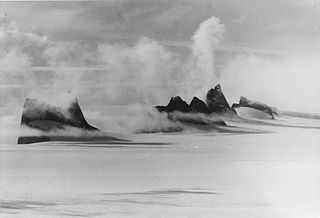
WPrincess Astrid Coast is a portion of the coast of Queen Maud Land, Antarctica, lying between 5° and 20° E. The entire coast is bordered by ice shelves. The region was discovered by Capt. H. Halvorsen of the Sevilla (ship) in March 1931 and in 1932 was named for Princess Astrid of Norway. The ice of the continental glacier, which is up to 4,000 meters thick in the interior. These thick glaciers are held in place by coastal mountain ranges. On the Princess Astrid Coast, some of the ice does flow through the mountains, spilling onto the relatively flat land on the Princess Astrid Coast. Also, the cold air spills over the mountains, creating very strong and persistent winds, which makes the snow scour off the tops of the glaciers leaving pale blue patches of bare ice. On top of the coastal line is the ice shelf, which is much smoother. The glacial ice floats on the sea surface which is beyond the chaotic surface of the sea ice which has been solidifying all winter long.
WLake Priyadarshini is a freshwater lake in the Schirmacher Oasis, Antarctica. It supplies water for Maitri, India's second permanent station in Antarctica. Lake Priyadarshini was named after the then Prime Minister of India Indira Priyadarshini Gandhi.
WRiiser-Larsen Ice Shelf is an ice shelf about 250 miles (400 km) long on the coast of Queen Maud Land, Antarctica, extending from Cape Norvegia in the north to Lyddan Island and Stancomb-Wills Glacier in the south.
WRitscher Peak is a 2,790-metre (9,150 ft) peak located 11 kilometres (7 mi) west-southwest of Mount Mentzel in the Gruber Mountains of Queen Maud Land, Antarctica. This peak was discovered and mapped by the Third German Antarctic Expedition of 1938–39 and was named for Capt. Alfred Ritscher, leader of the expedition.
WRusskiye Mountains is a widely scattered group of mountains and nunataks between the Hoel Mountains and Sor Rondane Mountains in Queen Maud Land. The group was mapped from air photos taken by Norwegian Antarctic Expedition December 1958-Jan. 1959. The group was observed the same season by the Soviet Antarctic Expedition, apparently after the landing at Lazarev Station in March 1959, and named Gory Russkiye.
WSandeggtind Peak is a 3,055 metres (10,023 ft) tall peak, standing 1.5 km (1 mi) south of Sandho Heights on Sandegga Ridge in the Conrad Mountains, Queen Maud Land. It was discovered and photographed by the Third German Antarctic Expedition (1938–1939), led by Capt. Alfred Ritscher. It was mapped by Norway from air photos and surveys by NorAE, 1956–60, and named Sandeggtind.
WSandhøhallet Glacier is a small glacier flowing southeast from the southern slopes of Sandhø Heights in the Conrad Mountains of Queen Maud Land. It was mapped by Norway from air photos and surveys by the Norwegian Antarctic Expedition of 1956–60, and named Sandhøhallet.
WSbrosovoye Lake is a small lake 1 nautical mile southwest of Tyuleniy Point in the Schirmacher Hills, Queen Maud Land. Mapped by the Soviet Antarctic Expedition in 1961 and named Ozero Sbrosovoye.
 W
WSchüssel Cirque is a large west-facing cirque containing Schüssel Moraine, in the north-central part of the Humboldt Mountains of Queen Maud Land. It was discovered by the German Antarctic Expedition under Alfred Ritscher, 1938–39, who referred to it as "In der Schüssel" and "Grosse Brei-Schüssel". The Advisory Committee on Antarctic Names has recommended a shorter form of the original names and has added the appropriate generic term.
WSigyn Glacier is a broad glacier flowing north between the Drygalski Mountains and the Kurze Mountains in Queen Maud Land. It was mapped and named from surveys and air photos by Norwegian Antarctic Expedition (1956–60) after Sigyn in Norse mythology.
WSkarsbrotet Glacier is a cirque-type glacier draining the east slopes of Skarshaugane Peaks, in the Humboldt Mountains of Queen Maud Land. Discovered and photographed by the German Antarctic Expedition, 1938–39. Mapped by Norway from air photos and surveys by the Norwegian Antarctic Expedition, 1956–60, and named Skarsbrotet.
WSkarskvervet Glacier is a small cirque-type glacier at the east side of Botnfjellet Mountain in the Humboldt Mountains of Queen Maud Land. Discovered and photographed by the German Antarctic Expedition, 1938–39. Mapped by Norway from air photos and surveys by Norwegian Antarctic Expedition, 1956–60, and named Skarskvervet.
WSnuggerud Glacier is a glacier flowing north-northeast between Klevekapa Mountain and Smaknoltane Peaks in the Filchner Mountains of Queen Maud Land. Mapped by Norwegian cartographers from surveys and air photos by the Norwegian Antarctic Expedition (1956–60) and named for J. Snuggerud, radio mechanic with Norwegian Antarctic Expedition (1956–58).
 W
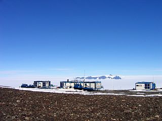
WTor research station is a Norwegian Antarctic research station in Queen Maud Land.
 W
WTottan Hills is a group of rocky hills 20 nautical miles (37 km) in extent, forming the southwestern portion of Heimefront Range in Queen Maud Land. The hills were observed and photographed by the Norwegian-British-Swedish Antarctic Expedition in the course of air reconnaissance from Maudheim in January 1952. Named after the supply ship Tottan, used to establish and resupply the British Royal Society IGY station on the Brunt Ice Shelf, 1955–58. During the 1957–58 season, Tottan also unloaded supplies at Norway station on Princess Martha Coast.
 W
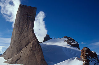
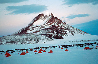
WUlvetanna Peak is a sharp peak in Queen Maud Land, Antarctica. It was first climbed in February 1994. The mountain was first discovered by the German Antarctic expedition in 1938 and named after the Swiss mountain Matterhorn because of its similar form. Later the mountain was renamed by the Norwegians to Ulvetanna Peak.
WVangengeym Glacier is a glacier about 6 nautical miles (11 km) long, draining the vicinity east of Mount Mentzel and flowing north toward Mount Seekopf in the Gruber Mountains, Queen Maud Land. It was discovered and plotted from air photos by the German Antarctic Expedition, 1938–39, and was mapped from air photos and surveys by the Norwegian Antarctic Expedition, 1956–60; remapped by Soviet Antarctic Expedition, 1960–61 and named after Soviet meteorologist Georgiy Vangengeym (1886–1961).
WVerblyud Island is an ice-covered island whose summit rises 200 m above the surrounding ice shelf, situated at the east margin of Lazarev Ice Shelf along the coast of Queen Maud Land. First mapped by the Soviet Antarctic Expedition (SovAE) in 1961 and named Kupol Verblyud.
WVestreskorve Glacier is a broad glacier in the Mühlig-Hofmann Mountains, to the south of Breplogen Mountain, which drains from a position opposite the head of Austreskorve Glacier northwestward along the west side of Svarthamaren Mountain. Plotted and named from surveys and air photos by the Norwegian Antarctic Expedition (1956–60).
WVeststraumen Glacier is a glacier about 45 miles long draining west along the south end of Kraul Mountains into Riiser-Larsen Ice Shelf. The glacier was seen in the course of a U.S. Navy LC-130 plane flight over the coast on November 5, 1967, and was plotted by the United States Geological Survey (USGS) from photographs obtained at that time. In 1969, the Advisory Committee on Antarctic Names (US-ACAN) gave the name "Endurance Glacier" to this feature, but that naming was rescinded because UK Antarctic Place-Names Committee (UK-APC) gave the identical name to a small glacier on Elephant Island. The descriptive name "Veststraumen" appears on a 1972 Norsk Polarinstitutt map.
WVindegghallet Glacier is a glacier flowing west for 4 nautical miles (7 km) along the south side of Mount Flanuten in the Humboldt Mountains of Queen Maud Land. Discovered and photographed by the German Antarctic Expedition, 1938–39. Mapped by Norway from air photos and surveys by Norwegian Antarctic Expedition, 1956–60, and named Vindegghallet in association with nearby Vindegga Spur.
WVinje Glacier is a broad glacier about 20 nautical miles (37 km) long flowing northwest between the Filchner Mountains and Fenriskjeften Mountain in Queen Maud Land. Mapped by Norwegian cartographers from surveys and air photos by the Norwegian Antarctic Expedition (1956–60) and named for T. Vinje, meteorologist with Norwegian Antarctic Expedition (1956–58).
WWeyprecht Mountains is a small group of mountains about 15 km (9 mi) west of the Payer Mountains, forming the western half of the Hoel Mountains in Queen Maud Land.
WZapadnoye Lake is a lake about 0.5 miles (0.8 km) long situated near the western end of the Schirmacher Hills, Queen Maud Land. Mapped by the Soviet Antarctic Expedition in 1961 and named Ozero Zapadnoye.
WZub Lake is a lake about 0.5 miles (800 m) long, lying 1 mile (1,600 m) east-southeast of Tsentral'naya Hill in the Schirmacher Hills, Queen Maud Land. The feature was mapped by the Soviet Antarctic Expedition in 1961 and named "Ozero Zub", presumably for its shape when viewed in plan.