 W
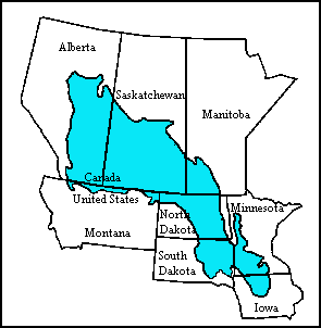
WMinnesota is the northernmost state outside Alaska; its isolated Northwest Angle in Lake of the Woods is the only part of the 48 contiguous states lying north of the 49th parallel. Minnesota is in the U.S. region known as the Upper Midwest. The state shares a Lake Superior water border with Michigan and Wisconsin on the northeast; the remainder of the eastern border is with Wisconsin. Iowa is to the south, North Dakota and South Dakota are west, and the Canadian provinces of Ontario and Manitoba are north. With 87,014 square miles (225,370 km2), or approximately 2.26 % of the United States, Minnesota is the 12th largest state.
 W
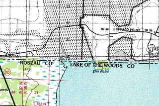
WElm Point, Minnesota, in Lake of the Woods County, Minnesota, is a small uninhabited cape and a United States practical exclave, southwest of the Northwest Angle, near the Indian/First Nation community of Buffalo Point. It borders Canada's province of Manitoba at the 49th parallel, and there is a line of felled trees along the 49th parallel marking the international border. The cape is separated from the rest of the continental United States by Lake of the Woods.
 W
WThe fourth principal meridian, set in 1815, is the principal meridian for land surveys in northwestern Illinois and west-central Illinois, and its 1831 extension is the principal meridian for land surveys in Wisconsin and northeastern Minnesota. It is part of the Public Land Survey System that covers most of the United States.
 W
WHerman Beach is one of several beaches delimiting the shorelines of the prehistoric glacial Lake Agassiz. Of note is that the beaches of Lake Agassiz are presently not adjacent to bodies of water, and consequently, are no longer really beaches at all. Named for its proximity to Herman, Minnesota, Herman Beach was formed 11,700 years ago and runs for hundreds of miles through Minnesota and North Dakota. It has been described as a smoothly-rounded beach ridge made of gravel and sand.
The Minnehaha Creek Watershed District's mission is to collaborate with public and private partners to protect and improve land and water for current and future generations. The Minnehaha Creek in its name refers to the water link from Lake Minnetonka to the Mississippi River. The watershed is much bigger than that lake or creek, and includes 29 communities, and encompasses 178 square miles (460 km2). It stretches West from about Minnehaha Falls to Saint Bonifacius and North to Maple Plain. It includes 129 lakes and 8 major creeks in Hennepin and Carver counties. Some of the lakes in the district are: Bde Maka Ska, Harriet, Nokomis, Parley, Minnewashta and Katrina.
 W
WThe northwesternmost point of the Lake of the Woods was a critical landmark for the boundary between U.S. territory and the British possessions to the north. This point was referred to in the Treaty of Paris in 1783 and in later treaties including the Treaty of 1818. This point lies at the corner of the Northwest Angle of Minnesota and is thus the northernmost point in the lower 48 United States. After Canadian Confederation, the point became the basis for the border between Manitoba and Ontario.
 W
WThe Prairie Pothole Region (PPR) is an expansive area of the northern Great Plains that contains thousands of shallow wetlands known as potholes. These potholes are the result of glacier activity in the Wisconsin glaciation, which ended about 10,000 years ago. The decaying ice sheet left behind depressions formed by the uneven deposition of till in ground moraines. These depressions are called potholes, glacial potholes, kettles, or kettle lakes. They fill with water in the spring, creating wetlands, which range in duration from temporary to semi-permanent. The region covers an area of about 800,000 sq. km and expands across five U.S. states and three Canadian provinces. The hydrology of the wetlands is variable, which results in long term productivity and biodiversity. The PPR is a prime spot during breeding and nesting season for millions of migrating waterfowl.