 W
WAlto Velo Island is a small uninhabited island south of the island of Hispaniola in the Caribbean Sea. Its maximum height is about 152 metres above sea level. It lies on an underwater mountain range which continues to Beata Island and the southwestern coast of the Dominican Republic. It has an area of 1.02 km² and is 1.4 km long, being oval in shape.
 W
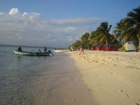
WLiterally "Eagles Bay", Bahia de las Aguilas is an 8 km long beach along the southwestern coast of the Dominican Republic near the southernmost part of the border with Haiti. The bay is part of the Jaragua National Park, and it is considered by many Dominicans as one of the most beautiful beaches in the world. The bay is a protected area as is the surrounding park, hence there is an abundance of sea life just feet off the beach within its waters.
 W
WThe Bahoruco Mountain Range—Sierra de Bahoruco is a mountain range located in the far southwestern region of the Dominican Republic. It is within Pedernales, Independencia, Barahona, and Bahoruco Provinces.
 W
WBeata Island is a small island on the Caribbean Sea, located 7 km (4 mi) southwest from Cape Beata. Some 12 km (7 mi) southwest of it lies the smaller Alto Velo Island. It is politically part of the Dominican Republic, and is roughly triangle-shaped and fairly flat, with an approximate area of 27 km2 (10 sq mi).
 W
WLiterally meaning "Red Cape", is both a cape on the southwestern coast of the Dominican Republic, and a beach on the same location. More specifically, it belongs to Pedernales Province, the southernmost province of the country.
 W
WJaragua National Park is a national park of the Dominican Republic. Jaragua National Park is located in Pedernales Province in the extreme southwest of the Dominican Republic. Jaragua National Park has an area of 1374 km², with coordinates from 17"28'N to 17'58'N and 71'16'W to 71"44'W, making it the largest protected area in the Caribbean region.
 W
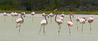
WLago de Oviedo, also known as Laguna de Oviedo, is a saltwater lake in Jaragua National Park, Pedernales Province, Dominican Republic. It is approximately 25 km2 in area, making it the second largest body of water in the Dominican Republic after Lake Enriquillo.