 W
WThe geology of Algeria is diverse; the country divides into three different tectono-stratigraphic domains. In the south and west is the West African Craton which consists of Precambrian granitic basement and surrounding Neoproterozoic mobile belts. Further south the Tuareg Shield comprises the Hoggar, Adrar des Iforas and Air sub-shields which have each been affected by tectono-thermal events touching much of the continent. In the north are the Alpine chain mountains with a succession of folded and over-thrusted strata.
 W
WThe Alpine orogeny or Alpide orogeny is an orogenic phase in the Late Mesozoic (Eoalpine) and the current Cenozoic that has formed the mountain ranges of the Alpide belt. These mountains include the Atlas, the Rif, the Baetic Cordillera, the Cantabrian Mountains, the Pyrenees, the Alps, the Apennine Mountains, the Dinaric Alps, the Pindus (Hellenides), the Carpathians, the Balkanides - Balkan Mountains and Rila-Rhodope massifs, the Pontic Mountains, the Taurus, the Armenian Highlands, the Caucasus, the Alborz, the Zagros, the Hindu Kush, the Pamir, the Karakoram, and the Himalayas. Sometimes other names occur to describe the formation of separate mountain ranges: for example Carpathian orogeny for the Carpathians, Hellenic orogeny for the Pindus, Altai orogeny for Altai Mountains or the Himalayan orogeny for the Himalayas.
 W
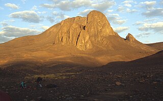
WAtakor volcanic field is a volcanic field in Algeria. It lies in the Hoggar mountains and consists of a variety of volcanic features such as lava flows and about 450 individual vents which create a spectacular scenery.
 W
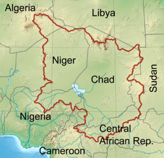
WThe Chad Basin is the largest endorheic basin in Africa, centered on Lake Chad. It has no outlet to the sea and contains large areas of semi-arid desert and savanna. The drainage basin is roughly coterminous with the sedimentary basin of the same name, but extends further to the northeast and east. The basin spans eight countries, including most of Chad and a large part of Niger. The region has an ethnically diverse population of about 30 million people as of 2011, growing rapidly.
 W
WThe Iullemmeden Basin is a major sub-Saharan inland basin in West Africa, extending about 1,000 kilometres (620 mi) north to south and 800 kilometres (500 mi) east to west. It covers western Niger and parts of Algeria, Mali and Nigeria. It is named after the Iullemmeden, a federation of Tuareg people who live in the central region of Niger. Its geographic range is largely coincident with the Azawagh region.
 W
WThe Taoudeni Basin is a major geological formation in West Africa, named after the Taoudenni village in northern Mali. It covers large parts of the West African craton in Mauritania and Mali. It is of considerable interest due to its possible reserves of oil.
 W
WThe Tindouf Basin is a major sedimentary basin in West Africa, to the south of the little Atlas region, Morocco. It stretches from west to east about 700 kilometres (430 mi) and covers about 100,000 square kilometres (39,000 sq mi), mostly in Algeria but with a western extension into Morocco and Western Sahara.