 W
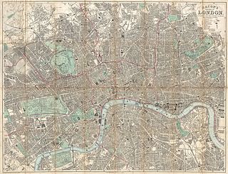
WGeorge Washington Bacon (1830–1922) was an American mapmaker and publisher who developed a successful business producing maps of London.
 W
WThe "Copperplate" map of London is an early large-scale printed map of the City of London and its immediate environs, surveyed between 1553 and 1559, which survives only in part. It is the earliest true map of London. The original map was probably designed for hanging on a wall, and is believed to have measured approximately 3 feet 8 inches (112 cm) high by 7 feet 5 inches (226 cm) wide. No copies of the printed map itself are known to have survived; but between 1962 and 1997 three of the original engraved copper printing-plates – from a probable total of 15 – were identified. Although only a fragmentary portion of the map is known, the three plates cover the greater part of the built-up heart of the City of London.
 W
WThe A–Z, or in full the Geographers' A–Z Street Atlas, is a name given to any one of a range of atlases of streets in the United Kingdom currently produced by Geographers' A–Z Map Company Limited. Its first atlas, of London, was originally compiled in the 1930s by Phyllis Pearsall. The company she founded now publishes street maps of many cities and towns in the UK.
 W
WJohn Rocque's Map of London, 1746, formally titled A plan of the cities of London and Westminster, and borough of Southwark, is a map of Georgian London to a scale of 26 inches to a mile, surveyed by John Rocque, engraved by John Pine, and published in 1746. The map consists of 24 sheets and measures 3.84 by 2.01 metres. Taking nearly ten years to survey, engrave and publish, it has been described as "a magnificent example of cartography ... one of the greatest and most handsome plans of any city".
 W
WThe Tube map is a schematic transport map of the lines, stations and services of the London Underground, known colloquially as "the Tube", hence the map's name. The first schematic Tube map was designed by Harry Beck in 1931. Since then, it has been expanded to include more of London's public transport systems, including the Docklands Light Railway, London Overground, TfL Rail, Tramlink and the Emirates Air Line cable car.
 W
WThe Wonderground Map was a 1914 London Underground map designed by MacDonald Gill and commissioned for the underground by Frank Pick, Commercial Manager of the then-Underground Electric Railways Company of London. It is known today as the map which "saved" the network, by encouraging off-peak travel; this was at a time when the underground was almost solely used by commuters in the mornings and evenings. Pick deliberately decided to commission a map which gave the company, as the BBC put it, a "stronger brand" as part of a simultaneous exercise in improving hygiene, punctuality, and image. As part of the latter, he also commissioned the "iconic" Johnston typeface for signs and lettering at the same time. Indeed, MacDonald's older brother, Eric Gill, worked with Johnston in creating his typeface.
 W
WThe "Woodcut" map of London, formally titled Civitas Londinum, and often referred to as the "Agas" map of London, is one of the earliest true maps of the City of London and its environs. The original map probably dated from the early 1560s, but it survives only in later and slightly modified copies. It was printed from woodcut blocks on eight sheets, and in its present state measures approximately 2 feet 4 inches (71 cm) high by 6 feet (180 cm) wide.