 W
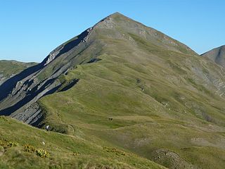
WGramos is a mountain range on the border of Albania and Greece. The mountain is part of the northern Pindus mountain range. Its highest peak, at the border of Albania and Greece, is 2,520 m (8,268 ft). The region is inhabited by Albanians, Aromanians and Greeks.
 W
WThe Ionian Sea is an elongated bay of the Mediterranean Sea. It is connected to the Adriatic Sea to the north, and is bounded by Southern Italy, including Calabria, Sicily, and the Salento peninsula to the west, southern Albania to the north, and the west coast of Greece, including the Peloponnese.
 W
WLake Gistova is an alpine lake on the border of Albania and Greece. It is located at an elevation of about 2,350 metres (7,710 ft), on the Gramos mountain. The nearest villages are Starje in Albania and Gramos in Greece.
 W
WThe Prespa lakes are two freshwater lakes, with the larger shared between North Macedonia, Albania, and Greece, and the smaller shared between Greece and Albania. Of the total surface area of the larger lake, 176.3 km2 (68.07 sq mi) belongs to North Macedonia, 46.3 km2 (17.88 sq mi) to Albania and 36.4 km2 (14.05 sq mi) to Greece. They are the highest tectonic lakes in the Balkans, standing at an elevation of 853 m (2,798 ft).
 W
WThe Protocol of Corfu, signed on May 17, 1914, was an agreement between the representatives of the Albanian Government and the Provisional Government of Northern Epirus, which officially recognized the area of Northern Epirus as an autonomous self-governing region under the sovereignty of the prince of the newly established Principality of Albania. The agreement granted the Greeks of the districts of Korytsa and Argyrokastro, which form Northern Epirus, wider religious, educational, cultural and political autonomy, inside the borders of the Albanian state.
 W
WThe Sarantaporos is a river in northwestern Greece and southern Albania. It is a right tributary of the river Aoös (Vjosë), which flows into the Adriatic Sea. Its length is 50 km (31 mi), of which the final approx. 10 km (6.2 mi) form the border between Greece and Albania. Its source is between the mountain ranges Gramos and Voio, in the Kastoria regional unit. It flows through the municipal units Arrenes, Mastorochoria and Konitsa in Greece, and the municipalities Qendër Leskovik and Çarshovë in Albania. Its basin area is 870 km2 (340 sq mi), and its year-average discharge is 6.93 m3 (245 cu ft) per second.
 W
WThe Straits of Corfu or Corfu Channel is the narrow body of water along the coasts of Albania and Greece to the east separating these two countries from the Greek island of Corfu on the west. The channel is a passage from the Adriatic Sea on the north to the Ionian Sea that is used by shipping local to Albania and Greece to the ports of Saranda, Albania, and Igoumenitsa, Greece, and by local and tourist traffic in Albania and from the Greek mainland to Corfu, in addition to some international traffic from the Adriatic.
 W
WUnited Nations Security Council Resolution 15, adopted unanimously on December 19, 1946, established a commission to investigate the nature of, and recommend a solution to, the alleged border violations along the frontier of Greek with Albania, Bulgaria and Yugoslavia. The commission was to arrive on site no later than January 15, 1947 and issue a report to the Council as soon as possible.