 W
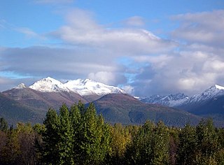
WAnchorage, Alaska has a subarctic climate with the code Dfc according to the Köppen climate classification due to its short, cool summers. Average daytime summer temperatures range from approximately 55 to 78 °F ; average daytime winter temperatures are about 5 to 30 °F. Anchorage has a frost-free growing season that averages slightly over one hundred days.
 W
WThe climate of Chicago is classified as hot-summer humid continental, with all four seasons distinctly represented: Winters are cold and see frequent snow and near 0 °F (−18 °C) windchill temperatures, while summers are warm and humid with temperatures being hotter inland, spring and fall bring bouts of both cool and warm weather and fairly sunny skies. Annual precipitation in Chicago is moderate and relatively evenly distributed, the driest months being January and February and the wettest July and August. Chicago's weather is influenced during all four seasons by the nearby presence of Lake Michigan.
 W
WLittle Rock has a humid subtropical climate, with hot, usually humid summers, but subject to drought, primarily in late summer. According to the Trewartha climate classification system, Little Rock is subtropical because nine of its months exceed 50 °F (10 °C) in average temperature. Summers are usually hot, occasionally extremely hot; winters are short and cool, but with marked temperature variations, as the area is subject to alternating incursions of warm, moist air from the Gulf of Mexico and cold, dry air from Canada. The Little Rock area has nearly 50 inches of precipitation per year, on average. Little Rock experiences a prolonged spring wet season, with heavy rainfall a distinct possibility from March to May, and a secondary wet season peaking in November and December. On average, August is the driest month, and July through September is the driest period of the year. Little Rock averages more rain than the national average, but also averages more sunny days than the national average. Thunderstorms can occur any month of the year, but are especially frequent and severe in spring, when torrential rainfall, damaging thunderstorm winds, hail, and tornadoes are all significant threats; a secondary severe weather season peaks in November. Snow, sleet and freezing rain are rare, but can occur during the winter season, when cold Canadian air at ground level is overrun by warm, moist air from the Gulf of Mexico. Unless otherwise indicated, all normal data presented below are based on data at Bill and Hillary Clinton National Airport the official Little Rock climatology station, from the 1981−2010 normals period.
 W
WThe climate of Los Angeles is a year-round mild-to-hot and mostly dry climate for the LA metropolitan area in California. The climate is classified as a Mediterranean climate, which is a type of dry subtropical climate. It is characterized by seasonal changes in rainfall—with a dry summer and a winter rainy season. Under the modified Köppen climate classification, the coastal areas are classified as Csb, and the inland areas as Csa.
 W
WClimate of Miami is classified as having a tropical monsoon climate. With hot and humid summers; short, warm winters; and a marked drier season in the winter. Its sea-level elevation, coastal location, position just above the Tropic of Cancer, and proximity to the Gulf Stream shape its climate. With January averaging 69.2 °F (20.7 °C), winter features warm temperatures; cool air usually settles after the passage of a cold front, which produces much of the little amount of rainfall. Lows sometimes fall to or below 50 °F (10 °C), with an average 3 such occurrences annually, but rarely 40 °F (4 °C); from 1981 to 2010, temperatures reached that level in only eight calendar years. Highs generally reach 70 °F (21 °C) or higher, and fail to do so on only an average of 12 days annually.
 W
WThe climate of Minneapolis–Saint Paul is the long term weather trends and historical events of the Minneapolis–Saint Paul metropolitan area in east central Minnesota. Minneapolis and St. Paul, together known as the Twin Cities, are the core of the 15th largest metropolitan area in the United States. With a population of 3.6 million people, the region contains approximately 60% of the population of Minnesota. Due to its location in the northern and central portion of the U.S., the Twin Cities has the coldest average temperature of any major metropolitan area in the nation. Winters can be cold, summer is warm and humid, snowfall is common in the winter and thunderstorms with heavy rainfall occur during the spring, summer and autumn. Though winter can be cold, the area receives more sunlight hours in mid-winter than many other warmer parts of the country, including all of the Great Lakes states, the Pacific Northwest, parts of the South, and almost all of the Northeast. Unless otherwise indicated, all normals data presented below are based on data at Minneapolis/St. Paul International Airport, the official Twin Cities climatology station, from the 1981−2010 normals period.
 W
WThe climate of New York City features a humid subtropical climate (Cfa), with parts of the city transitioning into a humid continental climate. (Dfa) This gives the city cool, wet winters and hot, humid summers with plentiful rainfall all year round. Meteorological records have been kept at Central Park since 1821, although the station was relocated to a different part of the park on January 1, 1920. There are also other weather stations in the area including one at LaGuardia Airport, beginning in 1940, and at JFK Airport, beginning in 1948. However, due to Central Park's long records and central location, it is often considered the main station for the city. Hence, all records unless otherwise stated will be for this station.
 W
WThe Tampa Bay area has a humid subtropical climate closely bordering a tropical monsoon climate near the waterfront areas. There are two basic seasons in the Tampa Bay area, a hot and wet season from May through October, and a mild and dry season from November through April.