 W
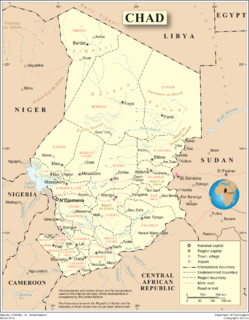
WChad is one of the 48 landlocked countries in the world and is located in North Central Africa, measuring 1,284,000 square kilometers (495,755 sq mi), nearly twice the size of France and slightly more than three times the size of California. Most of its ethnically and linguistically diverse population lives in the south, with densities ranging from 54 persons per square kilometer in the Logone River basin to 0.1 persons in the northern B.E.T. (Borkou-Ennedi-Tibesti) desert region, which itself is larger than France. The capital city of N'Djaména, situated at the confluence of the Chari and Logone Rivers, is cosmopolitan in nature, with a current population in excess of 700,000 people.
 W
WThe Aouzou Strip is a strip of land in northern Chad which lies along the border with Libya, extending south to a depth of about 100 kilometers into Chad's Borkou-Ennedi-Tibesti Region for an area of 114,000 km² and is named after the small town and oasis Aouzou. The region played a significant role in the Chadian–Libyan conflict.
 W
WThe East Saharan montane xeric woodlands is an ecoregion of central Africa, a number of high mountains in the middle of the huge area of savanna on the edge of the Sahara Desert.
 W
WThe terrain of Chad in central Africa is dominated by the low-lying Chad Basin, which rises gradually to mountains and plateaus on the north, east, and south.
WThe Mourdi Depression is a prominent desert depression of northeastern Chad. It lies adjacent to the Ennedi Plateau. The cleft lies "between the Erdi plateau and the eastern slopes of Ennedi, and the mouth of the Wadi Guroguro." The depression is characterized by a rocky valley, about 30 miles (48 km) wide from north to south, sloping from an altitude of about 1,800 feet (550 m) down towards the west to Djourab.
 W
WSoborom is a group of hot springs with accompanying fumaroles and mud volcanoes in the Tibesti Mountains of Chad. Three dispersed groups of vents are active there, some of which are used as spas by the local population.
 W
WSudan is the geographic region to the south of the Sahara, stretching from Western to eastern Central Africa. The name derives from the Arabic bilād as-sūdān, or "the lands of the Blacks", referring to West Africa and northern Central Africa. The Arabic name was translated as Negroland on older English maps.
 W
WThe Tibesti-Jebel Uweinat montane xeric woodlands is a deserts and xeric shrublands ecoregion in the eastern Sahara. The woodlands ecoregion occupies two separate highland regions, covering portions of northern Chad, southwestern Egypt, southern Libya, and northwestern Sudan.