 W
WThe 2010–2013 Southern United States and Mexico drought was a severe to extreme drought that plagued the Southern United States, including parts of Texas, Louisiana, Arkansas, Mississippi, Alabama, Georgia, South Carolina, North Carolina, and Oklahoma; the Southwestern States, including Kansas, Colorado, New Mexico, and Arizona; as well as large parts of Mexico, in a three-year pattern from 2010 to 2013.
 W
WThe 2011 Mexico fire season is the fire season which occurred between January and May 2011. Usually during May, the first wet-season rains begin to fall, followed by a soggy five months. As of May 20, 2011, the fire season had not slowed and the flames continued to burn forests. Fires burned throughout the country, casting a smoky haze from the Pacific Ocean to the Gulf of Mexico. 2011 turned out to be an extreme fire season in Mexico. By May 19, more than 530,000 hectares of land had burned in the country since the beginning of the year, according to the Mexican government. In terms of area burned, 2011 surpassed every year since 1998, making it one of the most challenging fire seasons for 30 years.
 W
WPreceded by more than a week of heavy rain, a slow-moving storm system dropped tremendous precipitation across much of Texas and Oklahoma during the nights of May 24–26, 2015, triggering record-breaking floods. Additionally, many areas reported tornado activity and lightning. Particularly hard hit were areas along the Blanco River in Hays County, Texas, where entire blocks of homes were leveled. On the morning of May 26, the National Weather Service issued a flash flood emergency for southwest Harris County and northeast Fort Bend County. The system also produced deadly tornadoes in parts of Mexico, Texas, and Oklahoma.
 W
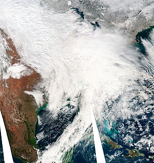
WThe January 31 – February 2, 2011 North American winter storm, also called the 2011 Groundhog Day Blizzard, was a powerful and historic winter storm, situated around the United States and Canada on Groundhog Day. During the initial stages of the storm, some meteorologists predicted that the system would affect over 100 million people in the United States. The storm brought cold air, heavy snowfall, blowing snow, and mixed precipitation on a path from New Mexico and northern Texas to New England and Eastern Canada. The Chicago area saw 21.2 inches (54 cm) of snow and blizzard conditions, with winds of over 60 mph (100 km/h). With such continuous winds, the Blizzard continued to the north and affected Eastern and Atlantic Canada. The most notable area affected in Canada was Toronto and the Greater Toronto Area. Blizzard conditions affected many other large cities along the storm's path, including Tulsa, Oklahoma City, Kansas City, St. Louis, Springfield, El Paso, Las Cruces, Des Moines, Milwaukee, Detroit, Indianapolis, Dayton, Cleveland, New York City, New York's Capital District, and Boston. Many other areas not normally used to extreme winter conditions, including Albuquerque, Dallas and Houston, experienced significant snowfall or ice accumulation. The central Illinois National Weather Service in Lincoln, Illinois issued only their fourth Blizzard Warning in the forecast office's 16-year history. Snowfall amounts of 20 to 28 inches were forecast for much of Northern and Western Illinois.
 W
WThe 2012–13 North American drought, an expansion of the 2010–13 Southern United States drought, originated in the midst of a record-breaking heat wave. Low snowfall amounts in winter, coupled with the intense summer heat from La Niña, caused drought-like conditions to migrate northward from the southern United States, wreaking havoc on crops and water supply. The drought inflicted significant economic ramifications for the affected states. It exceeded, in many measures, the 1988–89 North American drought, the most recent comparable drought.
 W
WThe February 5–6, 2010 North American blizzard, commonly referred to as Snowmageddon, was a paralyzing and crippling blizzard that had major and widespread impact in the Northeastern United States. The storm's center tracked from Baja California Sur on February 2nd, 2010 to the East coast on February 6, 2010, before heading east out into the Atlantic. Effects were felt to the north and west of this track in northern Mexico, California, and the Southwestern, Midwestern, Southeastern, and most notably Mid-Atlantic States. Severe weather, including extensive flooding and landslides in Mexico, and historic snowfall totals in every one of the Mid-Atlantic states, brought deaths to Mexico, New Mexico, Virginia, Pennsylvania and Maryland.
 W
WThe January 2014 Gulf Coast winter storm was a somewhat rare winter storm that impacted the eastern and southeastern United States, as well as Mexico, most notably the Gulf Coast region, which rarely receives frozen precipitation.
 W
WParícutin is a cinder cone volcano located in the Mexican state of Michoacán, near the city of Uruapan and about 322 kilometers (200 mi) west of Mexico City. The volcano surged suddenly from the cornfield of local farmer Dionisio Pulido in 1943, attracting both popular and scientific attention.