 W
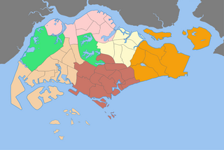
WPlanning Areas, also known as DGP areas or DGP zones, are the main urban planning and census divisions of Singapore delineated by the Urban Redevelopment Authority. There are a total of 55 of these areas, organised into five regions. A Development Guide Plan is then drawn up for each planning area, providing for detailed planning guidelines for every individual plot of land throughout the country.
 W
WThe architecture of Singapore displays a range of influences and styles from different places and periods. These range from the eclectic styles and hybrid forms of the colonial period to the tendency of more contemporary architecture to incorporate trends from around the world. In both aesthetic and technological terms, Singapore architecture may be divided into the more traditional pre-World War II colonial period, and the largely modern post-war and post-colonial period.
 W
WA development guide plan is a detailed urban land use plan for each of the 55 planning areas in Singapore designated by the Urban Redevelopment Authority (URA), Singapore's national planning and conservation authority.
 W
WThe Jackson Plan or Raffles Town Plan, an urban plan of 1822 titled "Plan of the Town of Singapore", is a proposed scheme for Singapore drawn up to maintain some order in the urban development of the fledgling but thriving colony founded just three years earlier. It was named after Lieutenant Philip Jackson, the colony's engineer and land surveyor tasked to oversee its physical development in accordance with the vision of Stamford Raffles for Singapore, hence it is also commonly called Raffles Town Plan. Raffles gave his instructions in November 1822, the plan was then drawn up in late 1822 or early 1823 and published in 1828. It is the earliest extant plan for the town of Singapore, but not an actual street map of Singapore as it existed in 1822 or 1827 since the plan is an idealised scheme of how Singapore may be organised that was not fully realised. Nevertheless, it served as a guide for the development of Singapore in its early days, and the effect of the general layout of the plan is still observable to this day.
 W
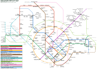
WThis is a list of all Mass Rapid Transit (MRT) stations in Singapore by their locations. For urban planning purpose, Singapore is officially divided into 55 planning areas by the Urban Redevelopment Authority. This list includes operational, non-operational and confirmed future stations on the MRT network.
WThe Regions of Singapore are urban planning subdivisions demarcated by the Urban Redevelopment Authority of Singapore to aid in its planning efforts. Over time, other governmental organisations have also adopted the five regions in their administrative work, as for example the Department of Statistics in the census of 2000. The regions are further subdivided into 55 planning areas, which include two water-catchment areas. The largest region in terms of area is the West Region with 201.3 km2 (77.7 sq mi), while the Central Region is the most populous with an estimated population of 922,980 inhabitants in the area in 2019.
Surbana Jurong Private Limited is a Singaporean government-owned consultancy company focusing on infrastructure and urban development. It was formed on 22 June 2015 with the merger of Surbana International Consultants and Jurong International Holdings. As of July 2016, it is wholly owned by Temasek Holdings and had 13,000 employees. Surbana Jurong acquired SMEC Holdings and AETOS Holdings on 1 August 2016 and 13 October 2016 respectively. These acquisitions have raised its staff count to 13,000 employees. On 1 November 2017, Surbana Jurong acquired Robert Bird Group, a global consulting engineering firm.
 W
WThe Urban Redevelopment Authority is the national urban planning authority of Singapore, and a statutory board under the Ministry of National Development of the Singapore Government.