 W
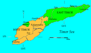
WThe East Timor–Indonesia border is the international border between East Timor and Indonesia. The border consists of two non-contiguous sections totalling 253 km in length, the larger section of which divides the island of Timor in two.
 W
WThe Indonesian invasion of East Timor, known in Indonesia as Operation Lotus, began on 7 December 1975 when the Indonesian military invaded East Timor under the pretext of anti-communism to overthrow the Fretilin regime that had emerged in 1974. The overthrow of the popular and briefly Fretilin-led government sparked a violent quarter-century occupation in which between approximately 100,000–180,000 soldiers and civilians are estimated to have been killed or starved to death. The Commission for Reception, Truth and Reconciliation in East Timor documented a minimum estimate of 102,000 conflict-related deaths in East Timor throughout the entire period 1974 to 1999, including 18,600 violent killings and 84,200 deaths from disease and starvation; Indonesian forces and their auxiliaries combined were responsible for 70% of the killings.
 W
WNoel Besi River is a river flowing in the west part of Timor island and forms part of the border between the East Timor exclave of Oecussi and Indonesian West Timor. It flows north into the Sawu Sea. Located 1900 km east of the Indonesian capital, Jakarta.
 W
WOecusse also known as: Oecusse-Ambeno, Portuguese: Oé-Cusse Ambeno, Tetum: Oecussi Ambeno, officially the Special Administrative Region Oecusse-Ambeno. Also variously Oecussi, Ocussi, Oekussi, Oekusi, Okusi, Oé-Cusse, and formerly just Ambeno, is both a municipality and a Special Administrative Region, and was formerly a district, of East Timor.
 W
WThe Ombai Strait is the strait which separates the Alor Archipelago from the islands of Wetar, Atauro, and Timor in the Lesser Sunda Islands. Wetar is part of the Maluku Province of Indonesia, the Alor Archipelago and the western part of Timor are part of the province of East Nusa Tenggara, Indonesia, while Atauro and the eastern part of Timor comprise the nation of East Timor. The strait connects the Banda Sea in the north to the Savu Sea to the southwest.
 W
WThe Timor Gap is an area of the Timor Sea between Australia and Timor Island. The island is divided between independent East Timor and West Timor province of Indonesia.
 W
WThe Timor Gap Treaty was formally known as the Treaty between Australia and the Republic of Indonesia on the zone of cooperation in an area between the Indonesian province of East Timor and Northern Australia. It was a bilateral treaty between the governments of Australia and Indonesia, which provided for the joint exploitation of petroleum and hydrocarbon resources in a part of the Timor Sea Seabed. The treaty was signed on 11 December 1989 and came into force on 9 February 1991. The signatories to the treaty were then Australian Foreign Affairs Minister Gareth Evans and then Indonesian Foreign Minister Ali Alatas.
 W
WThe Timor Sea is a relatively shallow sea bounded to the north by the island of Timor, to the east by the Arafura Sea, to the south by Australia.
WThe Wetar Strait separates the eastern part of the island of Timor from the island of Wetar. It thus lies between the nations of Indonesia to the north and East Timor to the south. To the west is Atauro, and beyond it the Ombai Strait; while to the east is the southern part of the Banda Sea and the southernmost of the Maluku Islands. At its narrowest point, the strait is 36 km across.