 W
WManagua is the capital and largest city of Nicaragua, and the center of an eponymous department. Located on the southwestern shore of Lake Managua and inside the Managua Department, it has an estimated population 1,042,641 in 2016 within the city's administrative limits and a population of 1,401,687 in the metropolitan area, which additionally includes the municipalities of Ciudad Sandino, El Crucero, Nindirí, Ticuantepe and Tipitapa.
 W
WThe 1931 Nicaragua earthquake devastated Nicaragua's capital city Managua on 31 March. It had a moment magnitude of 6.1 and a maximum MSK intensity of VI (Strong). Between 1,000 and 2,450 people were killed. A major fire started and destroyed thousands of structures, burning into the next day. At least 45,000 were left homeless and losses of $35 million were recorded.
 W
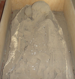
WThe Ancient footprints of Acahualinca exist in Managua, Nicaragua near the southern shore of Lake Managua. The region was once called "El Cauce". The tracks are fossil Late Holocene human footprints left behind in volcanic ash and mud, which solidified about 2,120±120 years ago, shortly after the group of up to 15 people passed by.
 W
WCarretera Norte, officially known as Kennedy Boulevard, is the main thoroughfare connecting the city of Managua to points east and west of the city. Its western end terminates at the Augusto C. Sandino International Airport, and the road continues east to the Pista Pedro Joaquin Chamorro.
 W
WLa Chureca was the municipal domestic and industrial waste-disposal site in Managua, Nicaragua. It was the largest open-air landfill in Central America, covering 7 km2 in the north-western corner of Managua. It is now covered and sealed, it is a modern waste dispose system which is located on the south shore of Lake Managua and it is near Acahualinca, home to the famous ancient footprints of Acahualinca. Out of the approximately 1,000 persons who reside at the dump, 50% are children under age 18. These children and families work at La Chureca sorting through the waste. Approximately 400 to 440 families live in La Chureca.
 W
WLos Placeres is an archeological site located between the “Waspán” and “Tabacalera Nicaragüense” neighborhoods at kilometer 4½ of the “Carretera Norte”, in Managua, en Nicaragua. The site extends to the coast of Lake Managua. A large part of the area that delimits the site is being impacted by a new urban settlement known as Barrio Hugo Chávez, which divides the site, where its new settlers have disturbed the ground for installation of pipes for drinking water, toilet and housing, this activity has caused a serious incidental findings and impacts to the prehispanic archaeological site.
WThe 1972 Nicaragua earthquake occurred at 12:29:44 a.m. local time on December 23 near Managua, the capital of Nicaragua. It had a moment magnitude of 6.3 and a maximum MSK intensity of IX (Destructive). The epicenter was 28 kilometers northeast of the city centre and a depth of about 10 kilometers. The earthquake caused widespread casualties among Managua's residents: 4,000–11,000 were killed, 20,000 were injured and over 300,000 were left homeless.
 W
WSe le movió el piso: A portrait of Managua is a documentary film by Anne Aghion about the many layers of destruction that the people in Managua, Nicaragua endured: the 1972 Nicaragua earthquake, four decades of dictatorship and many years of war. Most of the film was centered on the Salazar theater and the many families that lived there. Sofía Montenegro, a journalist and a former Sandinista, was also interviewed as a person who lived and experienced the challenges of the Managuans.
 W
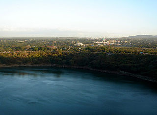
WTiscapa Lagoon is a lagoon of volcanic origin that formed over 10,000 years ago. It is located in the capital city of Managua in Nicaragua, and covers an area of 0.13 km2. Tiscapa Lagoon was protected as a natural reserve on October 31, 1991. The reserve is managed by the Ministry of the Environment and Natural Resources (MARENA) and comprises one of the 78 protected areas of Nicaragua.