 W
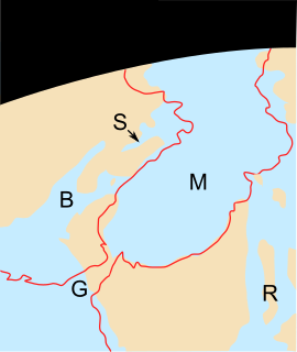
WThe Betic Corridor, or North-Betic Strait, was a strait of water connecting the Mediterranean Sea with the Atlantic Ocean that once separated the Iberian plate from the Eurasian plate through the Betic Cordillera. Its closure approximately 5.96 million years ago during the Messinian period of the Miocene epoch, precipitated the Messinian Salinity Crisis, a period when the Mediterranean Sea evaporated partly or completely.
 W
WThe geology of Great Britain is renowned for its diversity. As a result of its eventful geological history, Great Britain shows a rich variety of landscapes across the constituent countries of England, Wales and Scotland. Rocks of almost all geological ages are represented at outcrop, from the Archaean onwards.
 W
WThe Canadian Shield, also called the Laurentian Plateau, is a large area of exposed Precambrian igneous and high-grade metamorphic rocks that forms the ancient geologic core of the North American continent. Glaciation has left the area only a thin layer of soil, through which the composition of igneous rock resulting from long volcanic history is frequently visible. With a deep, common, joined bedrock region in eastern and central Canada, the Shield stretches north from the Great Lakes to the Arctic Ocean, covering over half of Canada and most of Greenland; it also extends south into the northern reaches of the United States. Human population is sparse and industrial development is minimal, but mining is prevalent.
 W
WEarthscope is an earth science program using geological and geophysical techniques to explore the structure and evolution of the North American continent and to understand the processes controlling earthquakes and volcanoes. The project has three components: USArray, the Plate Boundary Observatory, and the San Andreas Fault Observatory at Depth.
 W
WThe geology of the Himalaya is a record of the most dramatic and visible creations of modern plate tectonic forces. The Himalayas, which stretch over 2400 km between the Namcha Barwa syntaxis in Tibet and the Nanga Parbat syntaxis in Kashmir, are the result of an ongoing orogeny — the result of a collision of the continental crust of two tectonic plates. This immense mountain range was formed by tectonic forces and sculpted by weathering and erosion. The Himalaya-Tibet region supplies fresh water for more than one-fifth of the world population, and accounts for a quarter of the global sedimentary budget. Topographically, the belt has many superlatives: the highest rate of uplift, the highest relief, among the highest erosion rates at 2–12 mm/yr, the source of some of the greatest rivers and the highest concentration of glaciers outside of the polar regions. This last feature earned the Himalaya its name, originating from the Sanskrit for "the abode of the snow".
 W
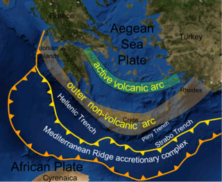
WThe Mediterranean Ridge is a wide ridge in the bed of the Mediterranean Sea, running along a rough quarter circle from Calabria, south of Crete, to the southwest corner of Turkey, and from there eastwards south of Cyprus and Turkey.
 W
WThe geology of North America is a subject of regional geology and covers the North American continent, third-largest in the world. Geologic units and processes are investigated on a large scale to reach a synthesized picture of the geological development of the continent.
 W
WThe Periadriatic Seam is a distinct geologic fault in Southern Europe, running S-shaped about 1000 km from the Tyrrhenian Sea through the whole Southern Alps as far as Hungary. It forms the division between the Adriatic plate and the European plate. The term Insubric line is sometimes used to address the whole Periadriatic Seam, but it is more commonly used to mean just a western part of it.
 W
WThe Richat Structure, also called Guelb er Richât, the Eye of Africa, or Eye of the Sahara is a prominent circular feature in the Sahara's Adrar Plateau, near Ouadane, west–central Mauritania, Northwest Africa. It is an eroded dome, 40 kilometres (25 mi) in diameter, exposing sedimentary rock in layers which appear as concentric rings. Igneous rock is exposed inside and there are spectacular rhyolites and gabbros which have undergone hydrothermal alteration, and a central megabreccia. The structure is also the location of exceptional accumulations of Acheulean archaeological artifacts.