 W
WChapman's Peak is the name of a mountain on the western side of the Cape Peninsula, between Hout Bay and Noordhoek in Cape Town, South Africa. The western flank of the mountain falls sharply for hundreds of metres into the Atlantic Ocean, and a road, known as Chapman's Peak Drive, hugs the near-vertical face of the mountain, linking Hout Bay to Noordhoek. Tourists and locals often stop at viewpoints along this road, which offer views of Hout Bay, The Sentinel Peak and surrounds, as well as over Noordhoek Beach.
 W
WThe M3 is an expressway in Cape Town, South Africa, connecting the upper part of the City Bowl to the Southern Suburbs and ending in Tokai. For most of its route it parallels - though further to the south and west - the M4, which was the original road connecting central Cape Town with the settlements to the south.
 W
WThe M5 is an expressway in Cape Town, South Africa. It connects the northern suburbs (Milnerton) to Muizenberg in the south, and crosses both the N1 and the N2. For part of its length, from the N1 interchange to Plumstead, it is a limited-access freeway (motorway).
 W
WThe M7, also named Jakes Gerwel Drive, is a limited-access road and metropolitan route in the City of Cape Town, South Africa. It is an extension of the N7 national road, which ends at an intersection with the N1. The M7 continues southwards from this intersection through the Cape Flats to end at the False Bay coast. Along its route it intersects with the R102, the N2, the R300 and the R310.
 W
WThe N1 is a national route in South Africa that runs from Cape Town through Bloemfontein, Johannesburg, Pretoria and Polokwane to Beit Bridge on the border with Zimbabwe. It forms the first section of the famed Cape to Cairo Road.
 W
WThe N2 is a national route in South Africa that runs from Cape Town through Port Elizabeth, East London and Durban to Ermelo. It is the main highway along the Indian Ocean coast of the country. Its total distance of 2,255 kilometres (1,401 mi) makes it the longest numbered route in South Africa.
 W
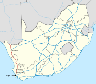
WThe N7 is a national route in South Africa that runs from Cape Town northwards through the West Coast and Namaqualand regions to the Namibian border at Vioolsdrif. After crossing the border, it changes designation to B1 and runs north through Windhoek and the north of Namibia.
 W
WOu Kaapse Weg, numbered as route M64, is a mountain pass in the Cape Peninsula that connects the Southern Suburbs of Cape Town with the Fish Hoek Valley. It traverses the Steenberg mountains and passes through the Silvermine Nature Reserve. Ou Kaapse Weg is one of three routes to the Fish Hoek Valley: the others are Chapman's Peak Drive along the Atlantic coast and Main Road along the False Bay coast. Despite its name, the pass was only constructed in 1968, by the Divisional Council of the Cape.
 W
WThe R300 or Kuils River Freeway is a Regional Route in the Cape Metropole, South Africa that connects Mitchells Plain with the N2, Kuils River, and the N1 at Bellville. The R300 is a freeway for its entire length; it forms part of the proposed Peninsula Expressway.