 W
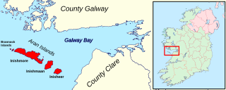
WThe Aran Islands or The Arans are a group of three islands located at the mouth of Galway Bay, on the west coast of Ireland, with a total area around 46 km2 (18 sq mi). They constitute the barony of Aran in County Galway, Ireland.
 W
WBaile na hAbhann, anglicised as Ballynahown, is a Gaeltacht village and townland about 31 km west of Galway, Ireland, on the R336 regional road between Indreabhán and Casla. The name means "river settlement".
 W
WBarna is a coastal village on the R336 regional road in Connemara, County Galway, Ireland. It has become a satellite village of Galway city. The village is Irish speaking and is therefore a constituent part of the regions of Ireland that make up the Gaeltacht.
 W
WBéal an Daingin or Béal a' Daingin is a small Gaeltacht village in Connemara (Conamara), County Galway, Ireland. The primary spoken language is Irish, and all but a few of the elderly population also speak English. There is a pub, a post office and a primary school (Toureen) within a few miles of the village.
 W
WCamus or Camas is a small village in the Connemara Gaeltacht of County Galway, Ireland. It is between Casla and An Teach Dóite, and is divided into Camas Uachtair and Camas Íochtair, as well as several other townlands, such as Scríob, Gleann Trasna, Leitir Móir, and Doire Bhainbh.
 W
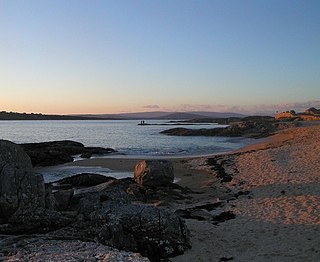
WCarraroe is a village in County Galway, Ireland, in the Irish-speaking region (Gaeltacht) of Connemara. It is known for its traditional fishing boats, the Galway Hookers. Its population is widely dispersed over the Carraroe peninsula between Cuan an Fhir Mhóir and Cuan Chasla. Carraroe has an unusual beach, Trá an Dóilín, a biogenic gravel beach made of coralline algae known as "maerl".
 W
WCasla is a Gaeltacht village between Indreabhán (Inverin) and An Cheathrú Rua (Carraroe) in western County Galway, Ireland. The headquarters of RTÉ Raidió na Gaeltachta is located there. The village lies on the R336 road beside Clynagh Bay. Casla means "(twisting) creek" or "inlet from the sea" in Irish.
WBaile Chláir or Baile Chláir na Gaillimhe is a Gaeltacht village about 10 km north of Galway city in County Galway, Ireland. Claregalway was founded on the banks of the River Clare, hence the derivation of its name: Baile Chláir na Gaillimhe meaning "town on the Clare, in Galway". Claregalway lies within the Gaeltacht and traditionally most of the locals would have spoken English only as a second language. Until September 2017, the village sat at the junction of the busy N17 and N18 national primary routes with over 27,000 vehicles having formerly passed through the village every day.
 W
WAn Fhairche, or Clonbur in English, is a Gaeltacht village in County Galway, Ireland.
 W
WConnemara is a cultural region in County Galway, in the west of Ireland. The area has a strong association with traditional Irish culture and contains a major part of the Connacht Irish-speaking Gaeltacht, which is a key part of the identity of the region and is the largest Gaeltacht in the country.
WCorr na Móna is a village and townland in County Galway, Ireland. It is part of the Gaeltacht in Joyce Country, and of the possible future geopark.
 W
WDinish,, is a small island on the coast of Connemara in County Galway, Ireland.
 W
WFurbo or Furbogh is a settlement with a population of around 300 in Connemara, County Galway, Ireland. It lies along the coast between Barna and Spiddal. It is a Gaeltacht area where Irish is the main language used in the school, church and at community meetings. The figure for those who self-report as speaking Irish daily is 39%. The headquarters of the Gaeltacht Authority, Údarás na Gaeltachta, is located in Na Forbacha.
 W
WInisheer is the smallest and most eastern of the three Aran Islands in Galway Bay, Ireland. With about 260 permanent residents, it is more populous than Inishmaan but less than Inishmore. Caomhán of Inis Oírr is the island's patron saint. There are five primary settlements on Inis Oírr, including Baile Thiar, Chapeltown, Castle Village, Baile an Fhormna and Baile an Lorgain.
 W
WInishmaan is the middle of the three main Aran Islands in Galway Bay on the west coast of Ireland. It is part of County Galway in the province of Connacht. Inishmaan has a population of about 183, making it the smallest of the Aran Islands in terms of population. It is one of the most important strongholds of traditional Irish culture. The island is predominantly Irish-speaking and part of the Gaeltacht, though all inhabitants have knowledge of English.
WInis Mór is the largest of the Aran Islands in Galway Bay in Ireland and has an area of 31 km2 (12 sq mi). Inis Mór has a population of about 840, making it the largest of the Aran Islands in terms of population and largest island off the Irish coast with no bridge or causeway to the mainland.
 W
WInishnee is a small island off the shore of Ireland, in Roundstone Bay near the village of Roundstone in Connemara in County Galway. The island is equipped with a lighthouse. As of 2011, it had a population of 43.
 W
WInverin is a Gaeltacht village between Baile na hAbhann and Minna in County Galway, Ireland. There are Irish-language summer colleges in the area, most notably Coláiste Lurgan and Coláiste Uí Chadhain.
 W
WCill Chiaráin is a coastal village in the Connemara area of County Galway, in the Republic of Ireland. The R340 passes through Cill Chiaráin.
 W
WCill Rónáin is the main settlement on Inishmore, one of the Aran Islands off the west coast of Ireland in County Galway. The ferries serving the island call at Doolin, County Clare and also Ros an Mhíl, County Galway. The main industries are fishing and tourism. The village is situated in the Gaeltacht and School children visit to improve their Irish at summer schools. As of 2016, 247 people live in the village and 43.3% of the population speak Irish on a daily basis outside the education system.
 W
WLettermore is a Gaeltacht village in County Galway, Ireland. It is also the name of an island, linked by road to the mainland, on which the village sits. The name comes from the Irish Leitir Móir meaning great rough hillside. The main spoken language of the area is Irish. Lettermore island is in two halves. The eastern half is known as Lettermore, while the western half is known as Lettercallow.
 W
WLettermullen,, is a small island and village on the coast of southern Connemara in County Galway, Ireland. It is about 58 km (36 mi) west of Galway city, at the far western end of Galway Bay, Lettermullen is the westernmost of three islands; Lettermullen, Gorumna and Lettermore, along with smaller islands collectively known as Ceantar na nOileán connected to the mainland by the bridges and causeways of R374. Lettermullen is in the parish of Kilcummin, barony of Moycullen, and province of Connaught. It forms one side of Kiegall Bay, and its northern end is part of the shore of Casheen Bay. The island comprises about 100 hectares of arable and pasture land. The inhabitants are chiefly employed in herring and cod fisheries and in the collection of seaweed for manure.
 W
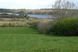
WRoss Lake is a freshwater lake in the west of Ireland. It is part of the Lough Corrib catchment in County Galway.
 W
WBallycuirke Lough, also known as Ballyquirke Lough, is a freshwater lake in the west of Ireland. It is part of the Lough Corrib catchment in County Galway.
 W
WLough Bofin is a freshwater lake in the west of Ireland. It is located in the Connemara area of County Galway.
 W
WGlendollagh Lough, also known as Garrowman Lough, is a freshwater lake in the west of Ireland. It is located in the Connemara area of County Galway.
 W
WLoch Na Fooey, also Loch Nafooey or Lough Nafooey, is a rectangular shaped glacial lake in County Galway, Ireland. Part of the north-eastern shore lies along the border to County Mayo. The closest village is Finny, County Mayo with the Galway village of Leenaun approximately 11 km distant.
 W
WOorid Lough is a freshwater lake in the west of Ireland. It is located in the Connemara area of County Galway.
 W
WMaam Cross is a crossroads in Connemara, County Galway, Ireland. It lies within the townland of Shindilla, at the junction of the N59 from Galway to Clifden and the R336 from Galway to the Maam Valley which runs from Maum or Maam to Leenaun or Leenane.
 W
WAn Mám is a small village with surrounding lands in Connemara, County Galway, Ireland.
 W
WThe Maumturks or Maamturks is a long, broadly-straight mountain range, consisting of weathered quartzite peaks in its central section, located in Connemara in County Galway, in the west of Ireland. The range lies opposite the Twelve Bens, on the other side of the Inagh Valley.
 W
WMoycullen is a Gaeltacht village in County Galway, Ireland, about 10 km (7 mi) northwest of Galway city. It is near Lough Corrib, on the N59 road to Oughterard and Clifden, in Connemara. Moycullen is now a satellite town of Galway with some residents commuting to the city for work, school, and business. Although Moycullen and its hinterland is classified as a ‘Gaeltacht’ area, the language has not been the local vernacular for many years. Moycullen falls under a Category C Gaeltacht Area due to its low percentage of daily Irish speakers.
 W
WRecess is a village in County Galway, Ireland. Its official name is in Irish, Sraith Saileach, and translates as "stream of the willow tree". A notable former resident was Seán Lester, the last Secretary General of the League of Nations, who lived there following his retirement until his death in 1959.
 W
WRosmuc or Ros Muc, sometimes anglicised as Rosmuck, is a village in the Conamara Gaeltacht of County Galway, Ireland. It lies halfway between the town of Clifden and the city of Galway. Irish is the predominant spoken language in the area, with the District Electoral Division of Turlough, Rosmuc, representing one of the highest percentages of Irish-speaking people in the country. The townland of Rosmuck is part of the civil parish of Kilcummin.
 W
WRossaveal or Rossaveel is a Gaeltacht village and townland in the Connemara area of County Galway, Ireland. It is the main ferry port for the Aran Islands in Galway Bay. It is about 37 kilometres (23 mi) from Galway city.
 W
WSpiddal is a village on the shore of Galway Bay in County Galway, Ireland. It is 18 kilometres (11 mi) west of Galway city, on the R336 road. It is on the eastern side of the county's Gaeltacht and of the Connemara region. According to the 2016 census, 35.3% of the population speak Irish on a daily basis outside the education system. It is a centre for tourism with a beach, harbour, and shore fishing. The village is part of the civil parish of Moycullen.
 W
WThe Twelve Bens or Twelve Pins is a mountain range of mostly sharp-peaked quartzite summits and ridges located in the Connemara National Park in County Galway, in the west of Ireland. The widest definition of the range includes the Garraun Complex to the north as well as several isolated peaks to the west, and is designated a 16,163-hectare Special Area of Conservation.
WWhite Goat Island is a small island off the north shore of Lough Corrib, close to Cornamona, in County Galway, Ireland. The three acre island was named after the prominent quartzite rock found on the south-west shore of the island.