 W
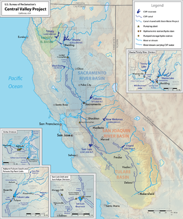
WThe Central Valley Project (CVP) is a federal power and water management project in the U.S. state of California under the supervision of the United States Bureau of Reclamation (USBR). It was devised in 1933 in order to provide irrigation and municipal water to much of California's Central Valley—by regulating and storing water in reservoirs in the northern half of the state, and transporting it to the water-poor San Joaquin Valley and its surroundings by means of a series of canals, aqueducts and pump plants, some shared with the California State Water Project (SWP). Many CVP water users are represented by the Central Valley Project Water Association.
 W
WThe American River is a 30-mile (50 km)-long river in California that runs from the Sierra Nevada mountain range to its confluence with the Sacramento River in downtown Sacramento. Via the Sacramento River, it is part of the San Francisco Bay watershed. This river is fed by the melting snowpack of the Sierra Nevada and its many headwaters and tributaries, including the North Fork American River, the Middle Fork American River, and the South Fork American River.
 W
WAuburn Dam was a proposed concrete arch dam on the North Fork of the American River east of the town of Auburn, California, in the United States, on the border of Placer and El Dorado Counties. Slated to be completed in the 1970s by the U.S. Bureau of Reclamation, it would have been the tallest concrete dam in California and one of the tallest in the United States, at a height of 680 feet (210 m) and storing 2,300,000 acre-feet (2.8 km3) of water. Straddling a gorge downstream of the confluence of the North and Middle Forks of the American River and upstream of Folsom Lake, it would have regulated water flow and provided flood control in the American River basin as part of Reclamation's immense Central Valley Project.
 W
WThe Auburn-Folsom South Unit is a project associated with the Central Valley Project in California and is one of three units located on the American River in Northern California, the United States Bureau of Reclamation is in charge of the Central Valley Project, including this project. The initial budget for this unit was 1.5 billion dollars. This unit includes a number of dams located on the American River, and work to divert and manage water in the area. The associated features of the Auburn-Folsom South Unit include the Folsom South Canal which was designed to change the direction of water flow at the Nimbus Dam along the American River near Sacramento in Northern California, Auburn Dam which was proposed to be built in the city of Auburn, California, the Sugar Pine Dam located in Placer County, and the County Line Dam and associated features of which construction was never initiated. The South Unit was approved by law in 1965, although actual construction of the projects did not begin until 1967. Some of the projects initially proposed to be a part of the unit were never halted once construction began, or were never started at all.
 W
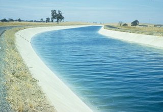
WThe C.W. Bill Jones Pumping Plant located 9 miles northwest of Tracy, CA, was constructed between 1947 and 1951, and is a key component of the Central Valley Project. The Delta Cross Channel intercepts Sacramento River water as it travels westwards towards Suisun Bay and diverts it south through a series of man-made channels, the Mokelumne River, and other natural sloughs, marshes and distributaries. From there, the water travels to the C.W. Bill Jones Pumping Plant, which raises water into the Delta-Mendota Canal, which in turn travels 117 miles (188 km) southwards to Mendota Pool on the San Joaquin River, supplying water to other CVP reservoirs about midway. The Tracy Fish Collection Facility exists at the entrance of the pump plant in order to catch fish that would otherwise end up in the Delta-Mendota Canal.
 W
WThe Chowchilla River is a river in central California, United States and a minor tributary of the San Joaquin River. It flows for 54.2 miles (87.2 km) from the western side of the Sierra Nevada Range to the San Joaquin River system in the San Joaquin Valley.
 W
WClear Creek is a tributary of the upper Sacramento River in northern California.
 W
WThe Contra Costa Canal is a 47 mi (76 km) aqueduct in the U.S. state of California. Its construction began in 1937, with delayed completion until 1948 due to World War II shortages in labor and materials. A portion of the canal's right of way has been developed as the Contra Costa Canal Regional Trail, a biking and walking trail, and is managed by the East Bay Regional Park District.
WDeer Creek, formerly More's Creek, is a creek in Tulare County, California. Its source is in the on the west slope of the Greenhorn Mountains, in the Sierra Nevada Mountain range. From there Deer Creek runs west to terminate at the Lakeland and Homeland Canals in the San Joaquin Valley just east of the Tulare - Kings County border. Originally it ran into Tulare Lake before it was diverted for agriculture.
 W
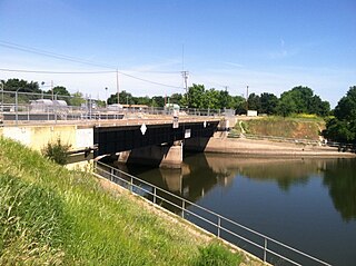
WThe Delta Cross Channel is a facility in California's Sacramento-San Joaquin Delta that diverts water from the Sacramento River. The facility was built in 1951 in Walnut Grove, California.
 W
WThe Delta–Mendota Canal is a 117-mile-long (188 km) aqueduct in central California, United States. The canal was designed and completed in 1951 by the U.S. Bureau of Reclamation as part of the Central Valley Project to supply freshwater to users downstream of the San Joaquin River. Freshwater is diverted into the Madera Canal and Friant-Kern Canal at Friant Dam.
 W
WFolsom Dam is a concrete gravity dam on the American River of Northern California in the United States, about 25 mi (40 km) northeast of Sacramento. The dam is 340 ft (100 m) high and 1,400 ft (430 m) long, flanked by earthen wing dams. It was completed in 1955, and officially opened the following year.
 W
WFolsom Lake is a reservoir on the American River in the Sierra Nevada foothills of California, United States.
 W
WFriant Dam is a concrete gravity dam on the San Joaquin River in central California in the United States, on the boundary of Fresno and Madera Counties. It was built between 1937 and 1942 as part of a U.S. Bureau of Reclamation (USBR) water project to provide irrigation water to the southern San Joaquin Valley. The dam impounds Millerton Lake, a 4,900-acre (2,000 ha) reservoir about 15 miles (24 km) north of Fresno.
 W
WThe Friant-Kern Canal is a 152 mi (245 km) aqueduct managed by the United States Bureau of Reclamation in Central California to convey water to augment irrigation capacity in Fresno, Tulare, and Kern counties. A part of the Central Valley Project, canal construction began in 1949 and was completed in 1951 at a cost of $60.8 million.
 W
WThe Kern River, originally Rio de San Felipe, later La Porciuncula, is a Wild and Scenic river in the U.S. state of California, approximately 165 miles (270 km) long. It drains an area of the southern Sierra Nevada mountains northeast of Bakersfield. Fed by snowmelt near Mount Whitney, the river passes through scenic canyons in the mountains and is a popular destination for whitewater rafting and kayaking. It is the southernmost major river system in the Sierra Nevada, and is the only major river in the Sierra that drains in a southerly direction.
 W
WLake Natoma is a small lake in the western United States, along the lower American River, between Folsom and Nimbus Dams in Sacramento County, California. The lake is located within the Folsom Lake State Recreation Area which is responsible for maintaining the facilities and bike trails surrounding the lake. Lake Natoma is located 15 miles east of Sacramento, and has 500 surface acres of water. The total length of lake Natoma is 4 miles.
 W
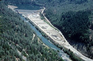
WLewiston Dam is an earthfill dam on the Trinity River that forms Lewiston Lake near Weaverville, California, United States. The 91 ft (28 m) high earthfill dam is 7 mi (11 km) downstream of Trinity Dam and was built by the U.S. Bureau of Reclamation. Construction was completed in 1963. Lewiston Lake and Dam are part of the Central Valley Project, which harnesses the waters from the Sacramento River and San Joaquin River watersheds to irrigate the Central Valley, and provide hydroelectricity.
 W
WMillerton Lake is an artificial lake near the town of Friant about 15 mi (24 km) north of downtown Fresno. The reservoir was created by the construction of 319 ft high Friant Dam on the San Joaquin River which, with the lake, serves as much of the county line between Fresno County to the south and Madera County to the north.
 W
WNew Melones Dam is an earth and rock filled embankment dam on the Stanislaus River, about 5 miles (8.0 km) west of Jamestown, California, United States, on the border of Calaveras County and Tuolumne County. The water impounded by the 625-foot (191 m)-tall dam forms New Melones Lake, California's fourth largest reservoir, in the foothills of the Sierra Nevada east of the San Joaquin Valley. The dam serves mainly for irrigation water supply, and also provides hydropower generation, flood control, and recreation benefits.
 W
WNew Melones Lake is a reservoir on the Stanislaus River in the central Sierra Nevada foothills, within Calaveras County and Tuolumne County, California.
 W
WThe Nimbus Dam is a base load hydroelectric dam on the American River near Folsom, California. Approximately 8,700 acre-feet (10,700 dam3) of water is retained by the dam. It is responsible for the impoundment of water from the American River to create the Lake Natoma reservoir. The dam stands 87 feet and spans 1,093 feet. The Nimbus powerplant consists of two generators. Each generator produces enough electrical power to power over 200,000 100-watt light bulbs, about 15,500 kilowatts of electrical power. Nimbus Dam consists of 18 radial gates, each with their own gate bays. These 18 gates today are the ones that were completed in 1955 along with the rest of the dam. Of the eighteen gates, four of them have had their coating system replaced. This protects the gates from a faster rate of corrosion. The other fourteen gates have the original coating.
 W
WO'Neill Dam is an earthfill dam on San Luis Creek, 12 miles (19 km) west of Los Banos, California, United States, on the eastern slopes of the Pacific Coast Ranges of Merced County. Forming the O'Neill Forebay, a forebay to the San Luis Reservoir, it is roughly 2.5 miles (4.0 km) downstream from the San Luis Dam.
WO'Neill Forebay is a forebay to the San Luis Reservoir created by the construction of O'Neill Dam across San Luis Creek approximately 12 miles (19 km) west of Los Banos, California, United States, on the eastern slopes of the Pacific Coast Ranges of Merced County.
WPoso Creek or Posey Creek is an 87.9-mile (141.5 km) intermittent stream in Kern County, California.
 W
WRed Bluff Diversion Dam is a disused irrigation diversion dam on the Sacramento River in Tehama County, California, United States, southeast of the city of Red Bluff. Until 2013, the dam provided irrigation water for two canals that serve 150,000 acres (61,000 ha) of farmland on the west side of the Sacramento Valley. The dam and canals are part of the Sacramento Canals Unit of the Central Valley Project, operated by the U.S. Bureau of Reclamation. In 2013, the dam was decommissioned and the river allowed to flow freely through the site in order to protect migrating fish. A pumping plant constructed a short distance upstream now supplies water to the canal system.
The Refuge Water Supply Program (RWSP) is administered by the United States Department of the Interior jointly by the Bureau of Reclamation and Fish and Wildlife Service and tasked with acquiring a portion and delivering a total of 555,515 acre feet (AF) of water annually to 19 specific protected wetland areas in the Central Valley of California as mandated with the passing of the Central Valley Project Improvement Act signed on October 30, 1992, by President George H. W. Bush.
 W
WThe Sacramento River is the principal river of Northern California in the United States and is the largest river in California. Rising in the Klamath Mountains, the river flows south for 400 miles (640 km) before reaching the Sacramento–San Joaquin River Delta and San Francisco Bay. The river drains about 26,500 square miles (69,000 km2) in 19 California counties, mostly within the fertile agricultural region bounded by the Coast Ranges and Sierra Nevada known as the Sacramento Valley, but also extending as far as the volcanic plateaus of Northeastern California. Historically, its watershed has reached as far north as south-central Oregon where the now, primarily, endorheic (closed) Goose Lake rarely experiences southerly outflow into the Pit River, the most northerly tributary of the Sacramento.
 W
WThe San Joaquin River is the longest river of Central California. The 366-mile (589 km) long river starts in the high Sierra Nevada, and flows through the rich agricultural region of the northern San Joaquin Valley before reaching Suisun Bay, San Francisco Bay, and the Pacific Ocean. An important source of irrigation water as well as a wildlife corridor, the San Joaquin is among the most heavily dammed and diverted of California's rivers.
WSan Luis Creek, originally Arroyo de San Luis Gonzaga, is a stream in Merced County, California. Its source is located near the eastern crest of the Diablo Range, west of San Luis Reservoir. It is dammed to form San Luis Reservoir in San Luis Reservoir State Park, and below that, O'Neill Forebay. From the latter the creek continues east to its confluence with Los Banos Creek, 3.6 mi (5.8 km) east of Ingomar, California. Los Banos Creek is tributary to the San Joaquin River.
 W
WSan Luis Dam is a major earth-filled dam in Merced County, California, which forms San Luis Reservoir, the largest off-stream reservoir in the United States. The dam and reservoir are located in the Diablo Range to the east of Pacheco Pass and about 10 miles (16 km) west of Los Banos. San Luis Dam, a jointly-owned state and federal facility, stores more than 2 million acre feet (2.5 km3) of water for the California State Water Project and the federal Central Valley Project. Although the dam is located in the valley of San Luis Creek, the majority of its water comes from man-made aqueducts which are supplied from other rivers in Northern California.
 W
WThe San Luis Reservoir is an artificial lake on San Luis Creek in the eastern slopes of the Diablo Range of Merced County, California, approximately 12 mi (19 km) west of Los Banos on State Route 152, which crosses Pacheco Pass and runs along its north shore. It is the fifth largest reservoir in California. The reservoir stores water taken from the San Joaquin-Sacramento River Delta. Water is pumped uphill into the reservoir from the O'Neill Forebay which is fed by the California Aqueduct and is released back into the forebay to continue downstream along the aqueduct as needed for farm irrigation and other uses. Depending on water levels, the reservoir is approximately nine miles long from north to south at its longest point, and five miles (8 km) wide. At the eastern end of the reservoir is the San Luis Dam, or the B.F. Sisk Dam, the fourth largest embankment dam in the United States, which allows for a total capacity of 2,041,000 acre-feet (2,518,000 dam3). Pacheco State Park lies along its western shores.
 W
WShasta Dam is a concrete arch-gravity dam across the Sacramento River in Northern California in the United States. At 602 feet (183 m) high, it is the eighth-tallest dam in the United States. Located at the north end of the Sacramento Valley, Shasta Dam creates Shasta Lake for long-term water storage, flood control, hydroelectricity and protection against the intrusion of saline water. The largest reservoir in the state, Shasta Lake can hold about 4,500,000 acre-feet (5,600 GL).
 W
WShasta Lake, also popularly known as Lake Shasta, is a reservoir in Shasta County, California, United States. It began to store water in 1944 due to the impounding of the Sacramento River by Shasta Dam, the ninth tallest dam in the United States.
 W
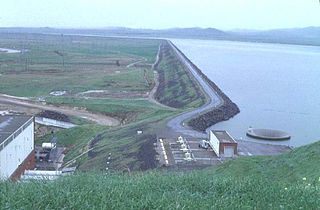
WSly Park Dam is located near Pollock Pines, California in the United States. The dam impounds Sly Park Creek and Hazel Creek, natural tributaries of the North Fork Cosumnes River, to form a 41,000 acre-foot (51,000 dam3), 650-acre (260 ha) reservoir called Jenkinson Lake. It was constructed as part of the American River Division of the Central Valley Project to provide irrigation water to a portion of El Dorado County, California. The dam was begun on May 1953, with clearing operations, and was completed in mid 1955.
 W
WSpring Creek Debris Dam is an earthfill dam on Spring Creek, a tributary of the Sacramento River, in Shasta County in the U.S. state of California. Completed in 1963, the dam, maintained by the U.S. Bureau of Reclamation, serves primarily to collect severe acid mine drainage stemming from the Iron Mountain Mine. The dam forms the Spring Creek Reservoir, less than 1 mile (1.6 km) long. Spring Creek and South Fork Spring Creek flow into the reservoir from a 16-square-mile (41 km2) watershed. The dam is directly upstream from the city of Keswick, California and the Keswick Reservoir. The operation is part of the Trinity River Division of the Central Valley Project.
 W
WThe Stanislaus River is a tributary of the San Joaquin River in north-central California in the United States. The main stem of the river is 96 miles (154 km) long, and measured to its furthest headwaters it is about 150 miles (240 km) long. Originating as three forks in the high Sierra Nevada, the river flows generally southwest through the agricultural San Joaquin Valley to join the San Joaquin south of Manteca, draining parts of five California counties. The Stanislaus is known for its swift rapids and scenic canyons in the upper reaches, and is heavily used for irrigation, hydroelectricity and domestic water supply.
 W
WSugar Pine Dam is an earthfill embankment dam in Placer County, California, approximately 7 miles (11 km) north of Foresthill. It impounds North Shirttail Creek, a tributary of the North Fork American River, and serves as the primary municipal water supply for the Foresthill community.
 W
WSugar Pine Reservoir is a reservoir in Placer County, California, located approximately 7 miles (11 km) north of Foresthill. The reservoir was flooded in 1982, and today supplies water to the community of Foresthill and hosts a number of recreation facilities.
 W
WTrinity Dam is an earthfill dam on the Trinity River located about 7 miles (11 km) northeast of Weaverville, California in the United States. The dam was completed in the early 1960s as part of the federal Central Valley Project to provide irrigation water to the arid San Joaquin Valley.
 W
WTrinity Lake, previously called Clair Engle Lake, is an artificial lake on the Trinity River formed by the Trinity Dam and located in Trinity County, California, United States. The dam was built by the U.S. Bureau of Reclamation. The lake's capacity is 2,447,650 acre⋅ft (3,019.13 GL), making it one of the largest reservoirs in California. The lake's surface is at 2,370 ft (720 m) above MSL. Trinity Lake captures and stores water for the Central Valley Project, which provides the Central Valley with water for irrigation and produces hydroelectric power. This lake is known for its many small arms, glassy inlets, and good water-skiing conditions.
 W
WWhiskeytown Dam is an earthfill dam on Clear Creek, a tributary of the Sacramento River of northern California in the United States.
 W
WWhiskeytown Lake is a reservoir in Shasta County in northwestern California, United States, about 8 miles (13 km) west of Redding. The lake is in the Whiskeytown Unit of the Whiskeytown-Shasta-Trinity National Recreation Area.