 W
WThe Adena culture was a Pre-Columbian Native American culture that existed from 500 BCE to 100 CE, in a time known as the Early Woodland period. The Adena culture refers to what were probably a number of related Native American societies sharing a burial complex and ceremonial system. The Adena culture was centered on the location of the modern state of Ohio, but also extended into contiguous areas of northern Kentucky, eastern Indiana, West Virginia, and parts of extreme western Pennsylvania.
 W
WThis is a list of Adena culture sites. The Adena culture was a Pre-Columbian Native American culture that existed from 1000 to 200 BCE, in a time known as the early Woodland Period. The Adena culture refers to what were probably a number of related Native American societies sharing a burial complex and ceremonial system. The Adena lived in a variety of locations, including: Ohio, Indiana, West Virginia, Kentucky, and parts of Pennsylvania and New York.
WAdena Mound, the type site for the Adena culture of prehistoric mound builders, is a registered historic structure, on the grounds of the Adena Mansion for which it is named, near Chillicothe, Ohio, was listed in the National Register on June 5, 1975.
 W
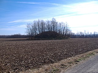
WThe Arledge Mounds are a pair of Native American mounds in the south central part of the U.S. state of Ohio. Located near Circleville in Pickaway County, the two mounds lie in the middle of a farm field, far from any roads. These two mounds are disparate in size: while the smaller mound's height is 5 feet (1.5 m), the other's is 20 feet (6.1 m), and their diameters are approximately 65 feet (20 m) and 120 feet (37 m) respectively.
 W
WThe Austin Brown Mound, also known as the "Dwight Fullerton Mound," is a subconical Native American mound located northwest of the city of Chillicothe in Ross County, Ohio, United States. In 1897, the Ohio Historical Society sponsored an excavation of the mound under the leadership of Clarence Loveberry, who oversaw the digging of a large tunnel into the mound's side. Loveberry's investigation yielded artifacts of the Adena culture and evidence of rotten logs on the floor of the mound, but in publishing the results of his excavation, he observed that neither a tomb nor any isolated burials were discovered within the mound. Since 1897, other Adena mounds have been excavated and shown to have wooden tombs in off-center locations, presumably to complicate the efforts of those who would loot the mounds; accordingly, it is possible that the Brown mound likewise has an off-center tomb.
 W
WThe Beam Farm Woodland Archaeological District is a group of archaeological sites in the southwestern part of the U.S. state of Ohio. Located at 3983 Stone Road near the village of Sabina in Clinton County, the district is composed of one Native American mound and two other archaeological sites spread out over an area of 2 acres (0.81 ha). Known as the Beam Farm Mound and the Beam Sites 9 and 12, the sites that compose the district have yielded artifacts from the Adena culture and the Hopewell tradition, both of which inhabited southwestern Ohio during the Woodland period. Because both the Adena and the Hopewell lived around the mound, and because both cultures built mounds, the identity of the people who constructed the Beam Farm Mound cannot be established; all that can be known with reasonable certainty is that it was raised during the early or middle portion of the Woodland period, or between 800 BC and AD 500.
 W
WThe Biggs Site (15Gp8), also known as the Portsmouth Earthworks Group C, is an Adena culture archaeological site located near South Shore in Greenup County, Kentucky. Group C was originally a large series of concentric circular embankments and ditches surrounding a central conical burial mound. It was part of a larger complex, the Portsmouth Earthworks located across the Ohio River, now mostly obliterated by agriculture and the developing city of Portsmouth, Ohio. The site was surveyed and mapped by E. G. Squier in 1847 for inclusion in the seminal archaeological and anthrolopological work Ancient Monuments of the Mississippi Valley.
 W
WThe Carl Potter Mound is a historic Native American mound in southern Champaign County, Ohio, United States. Located near Mechanicsburg, it lies on a small ridge in a pasture field in southeastern Union Township. In 1974, the mound was listed on the National Register of Historic Places as a potential archaeological site, primarily because of its use as a burial mound.
 W
WCedar-Bank Works is group of Adena culture earthworks located in Ross County, Ohio in the United States. It is located approximately five miles north of the town of Chillicothe, Ohio.
 W
WThe Columbus Country Club Mound is a Native American burial mound at the Columbus Country Club in Columbus, Ohio. The mound was created around 2,000 years ago by the Pre-Columbian Native American Adena culture. The site was added to the National Register of Historic Places in 1974.
 W
WThe Conrad Mound Archeological Site is an archaeological site in the southwestern part of the U.S. state of Ohio. Located east of Cleves in Hamilton County, the site is centered on an isolated Native American mound. Its location atop a ridgeline has been interpreted as evidence that the mound was constructed by the Adena culture. No artifacts have been found at the site, for no archaeological excavation has ever been carried out; however, experience with other sites has led archaeologists to surmise that the mound is surrounded by a larger zone of archaeological interest. Because of its potential archaeological value, the mound was listed on the National Register of Historic Places in 1975.
 W
WThe Coon Hunters Mound is a Native American mound in the central part of the U.S. state of Ohio. Located near the village of Carroll, it sits on the grounds of the Central Ohio Coonhunters Association.
 W
WThe Cowan Creek Circular Enclosure (33CN11) is an earthworks complex in the southwestern part of the U.S. state of Ohio. Named for its location near the stream known as Cowan Creek, the enclosure is an important archaeological site, and it is protected as part of a state park.
 W
WThe Criel Mound, also known as the South Charleston Mound, is a Native American burial mound located in South Charleston, West Virginia. It is one of the few surviving mounds of the Kanawha Valley Mounds that were probably built in the Woodland period after 500 B.C. The mound was built by the Adena culture, probably around 250–150 BC, and lay equidistant between two “sacred circles”, earthwork enclosures each 556 feet (169 m) in diameter. It was originally 33 feet (10 m) high and 173 feet (53 m) in diameter at the base, making it the second-largest such burial mound in the state of West Virginia. This archaeological site is listed on the National Register of Historic Places.
 W
WThe D.S. Rose Mound was a Native American mound in the southwestern part of the U.S. state of Ohio. Located north of Huntsville in Butler County, the mound was also known as the "Holloway Mound." Its placement on a ridgeline above flat countryside has been interpreted as an indication that it was built by the Adena culture.
 W
WThe David Stitt Mound is a Native American mound near Chillicothe in Ross County, Ohio, United States. Located on elevated land at a significant distance from the Scioto River, the mound is built in a sub-conical shape; it is 19.4 feet (5.9 m) high and has a diameter of approximately 130 feet (40 m).
 W
WThe Grave Creek Mound in the Ohio River Valley in West Virginia is one of the largest conical-type burial mounds in the United States, now standing 62 feet (19 m) high and 240 feet (73 m) in diameter. The builders of the site, members of the Adena culture, moved more than 60,000 tons of dirt to create it about 250–150 BC.
 W
WThe Great Mound is a massive Native American mound in the southwestern part of the U.S. state of Ohio. Located in Section 19 of Madison Township in Butler County, it has a height of 43 feet (13 m) and a circumference of 511 feet (156 m). Its total volume is nearly 825,000 cubic feet (23,400 m3), making it the largest mound in Butler County and one of the largest in southwestern Ohio. Because of the mound's height and its placement on a ridgeline, an individual at the summit can see for a great distance. In the late nineteenth century, it was theorized that mounds such as the Great Mound were built as observation or watch points, and that the builders maintained the ability to light fires atop the mounds as a method of communicating across wide distances. The potential of these mounds for long-distance communication was demonstrated in 1990 by three groups of volunteers. After climbing the Great Mound, the first group established visual contact with the Hill-Kinder Mound in Franklin, from which point the observers of the second group contacted the third group atop the Miamisburg Mound near Dayton.
 W
WThe Hansen Site (15GP14) is an archaeological site located near South Portsmouth in Greenup County, Kentucky, United States. The 6 hectare site is on a flood terrace of the Ohio River across from the mouth of the Scioto River, just upstream from the Lower Shawneetown site and the Old Fort Earthworks. The site was occupied several times over the centuries, with occupations dating from the Late Archaic, Middle Woodland, and Fort Ancient periods.
 W
WThe Hartley Mound is a Native American burial mound in Columbus, Ohio. The mound was created around 2,000 years ago by the Pre-Columbian Native American Adena culture. The site was added to the National Register of Historic Places in 1974. The mound measures 2 ft. high and 43 ft. in diameter. The site's location near a tributary to a major waterway, artifacts found nearby, and the small subconical form of the mound, suggests that it was built by the Adena culture. It is one of few mounds not seriously disturbed by agriculture, industry, or illegal excavation. Upon archaeological excavation, the site should provide information on Adena burial customs and domestic or mortuary structures.
 W
WThe Highbanks Metropolitan Park Mounds I and II are two archaeological sites located within Highbanks Metro Park in Central Ohio in the United States. The park is in southernmost Delaware County on the east bank of the Olentangy River. The subconical mounds are believed to have been built by the Adena culture.
 W
WThe Hillside Haven Mound is a Native American mound in the southwestern part of the U.S. state of Ohio. Located southwest of Oakland in Clinton County, it sits in dense woodland on the side of a hill. It is believed to have been conical in shape at the time of construction, but today it is rounded in shape, measuring 2.5 feet (0.76 m) high and 33 feet (10 m) in diameter.
 W
WThe Hodgen's Cemetery Mound is a Native American mound in the far eastern part of the U.S. state of Ohio. Located in the village of Tiltonsville along the Ohio River shoreline of Jefferson County, the mound is a prehistoric earthwork and archaeological site, and it has been named a historic site.
 W
WThe Horn Mound is a Native American mound in eastern Pickaway County, Ohio, United States. Located near the village of Tarlton, the mound sits along a stream at a significant distance from any other prehistoric sites. It is believed to have been built by people of the Adena culture, who constructed many burial mounds and other ceremonial earthworks in prehistoric Ohio. Although erosion by the nearby stream has the potential of damaging the mound, it appears to be virtually undisturbed by human exploration. Because of its pristine state, the Horn Mound is a likely archaeological site, and for this reason it was listed on the National Register of Historic Places in 1974.
WIndian Mound Reserve is a public country park near the village of Cedarville, Ohio, United States. Named for two different earthworks within its bounds — the Williamson Mound and the Pollock Works — the park straddles Massies Creek as it flows through a small canyon.
 W
WThe Jackson Mound is a Native American mound in the south-central portion of the U.S. state of Ohio. Located north of Pancoastburg in Fayette County, it measures approximately 75 feet (23 m) in diameter and 5.5 feet (1.7 m) in height. The mound has never been excavated, making the certain identification of its builders impossible; however, its location on a high terrace above a relatively small stream suggests that it was built by the Adena culture, which favored such sites for its many mounds. If true, it was originally more conical in shape, and it is likely to cover the remains of a wooden charnel house built by the Adena.
 W
WThe Karshner Mound is a Native American mound in the southeastern portion of the U.S. state of Ohio. Located near the village of Laurelville in Hocking County, it is one of Ohio's largest remaining burial mounds that has not been significantly damaged since white settlement. Measuring 100 feet (30 m) in diameter and 28 feet (8.5 m) high, it lies in the middle of a farm field, but it has never been cultivated, and vegetation on the mound has prevented erosion.
 W
WThe Luthor List Mound is an archaeological site of the Adena culture in the southern part of the U.S. state of Ohio. Located in Pickaway County near the city of Circleville, this Native American mound sits along the Kingston Pike, southeast of Circleville in Circleville Township.
 W
WThe Mann Mound is a Native American mound in the southwestern part of the U.S. state of Ohio. Located near the unincorporated community of Jacksonburg in Butler County, it is tree-covered and sits on the edge of a field in Section 12 of Wayne Township. Its height is approximately 20 feet (6.1 m), and its circumference is approximately 540 feet (160 m).
 W
WThe McLaughlin Mound, also called Cemetery Mound, is a Native American mound in the central part of the U.S. state of Ohio. Located in Mound View Cemetery near the city of Mount Vernon in Knox County, it is an important archaeological site.
 W
WThe Mound Cemetery Mound is a Native American mound in central Meigs County, Ohio, United States. Located in the eponymous Mound Cemetery, the mound lies north of the community of Chester in Chester Township. Because the mound has never been excavated and the cemetery has cared for it, it remains in fine condition. Its location near the Middle Branch of the Shade River, and the existence of numerous similar mounds nearby at one time, suggests that it was built by the Adena people, who were active 800 BCE to 100 CE. They were Early Woodland peoples. The mound is likely to contain remnants of a wooden structure that served as the burial place for a prominent member of Adena society.
 W
WMound Hill is an archaeological site in the Bluegrass region of the U.S. state of Kentucky. Located north of Winchester in far northern Clark County, the site is part of a group of Indian mounds lining Stoner Creek, although by far the largest of the group. The mound has frequently attracted attention from mapmakers and other surveyors, due to its large size; it was measured at 240 feet (73 m) (circumference) and 20 feet (6.1 m) (height) by an 1884 survey, which pronounced it a "romantic sight" due to its hilltop location between Stoner Creek and Pretty Run. The surveyors suggested that its linear shape with a central depression might have been the result of erosion or of the construction of multiple mounds that were later merged into one. It lies approximately 0.5 miles (0.80 km) west of the rest of the group, which occupies the summit of a narrow ridgeline known as the "Devil's Backbone." Digging at these mounds, which were seemingly related to Mound Hill, produced artifacts such as pottery and a pipe, as well as numerous stone box graves.
WThe Mount Horeb Earthworks Complex is an Adena culture group of earthworks in Fayette County, Kentucky. It consists of two major components, the Mount Horeb Site 1 and the Peter Village enclosure, and several smaller features including the Grimes Village site, Tarleton Mound, and Fisher Mound. The Peter Village and Grimes Village enclosures were mapped by Rafinesque and featured in Squier and Davis's landmark publication Ancient Monuments of the Mississippi Valley in 1848 as Plate XIV Figures 3 and 4.
 W
WThe Odd Fellows' Cemetery Mound is a Native American mound in the southwestern part of the U.S. state of Ohio. Located in the village of Newtown in Hamilton County, the mound is an oval approximately 110 feet (34 m) long and 90 feet (27 m) wide; its height is 11.3 feet (3.4 m). It is believed to have been built by the Adena culture.
 W
WThe Orators Mound is a Native American mound in the western part of the U.S. state of Ohio. Although its cultural affiliation is disputed, it is an important archaeological site.
 W
WThe Piketon Mounds are a group of earthworks located in Piketon, Ohio in the United States. The site is listed on the National Register of Historic Places. The specific age of the site is unknown. Some mounds were created by the Adena culture, while other mounds were built by the Hopewell culture.
 W
WThe Raleigh Mound (33KN32) is a Native American mound in the village of Fredericktown, Ohio, United States. Built thousands of years ago, the mound is an important archaeological site.
WThe Ramey Mound, designated 15BH1, is an archaeological site in Bath County in the northeastern part of the U.S. state of Kentucky. Built by people of the prehistoric Adena culture, the site has been known for more than two centuries; it was recorded in 1807 as consisting of an enclosure at least 3 feet (0.91 m) high. In 1871, another survey observed four mounds in association with the main earthwork: one was located just east of the enclosure, another directly to the west, a larger one to the southeast, and a small one to the southwest. The source of a nearby brook lies within the site and transverses the enclosure; the 1871 survey supposed that it had been dug to provide earth for the enclosure. By the time of this later survey, cultivation had reduced the earthwork to the point that it was nearly indistinguishable.
 W
WRock Eagle Effigy Mound is an archaeological site in Putnam County, Georgia, U.S. estimated to have been constructed c. 1000 BC to AD 1000. The earthwork was built up of thousands of pieces of quartzite laid in the mounded shape of a large bird. Although it is most often referred to as an eagle, scholars do not know exactly what type of bird the original builders intended to portray. It is listed on the National Register of Historic Places (NRHP) because of its significance. The University of Georgia administers the site. It uses much of the adjoining land for a 4-H camp, with cottages and other buildings, and day and residential environmental education.
WThe Ronald Watson Gravel Site (15BE249) is an archaeological site near Petersburg in Boone County, Kentucky, on an inside bend of a meander of the Ohio River. Excavations have determined that the site was occupied several times, during the Late Archaic, Middle Woodland, Late Woodland, and Middle Fort Ancient periods, although none of these are transitional occupations from one period to another. It is the best documented Middle Woodland site in the Northern Bluegrass region of Kentucky.
 W
WRound Hill is an unincorporated community in Madison County, Kentucky, United States. It lies 10 miles southwest of Richmond on County Road 595. A burial mound attributed by the National Register of Historic Places to the Adena Culture is the central feature of the village. The ovoid earthwork has a base of roughly 150 by 90 feet and a height of 25 feet. Unsystematic excavations in the early twentieth century by local residents produced flint tools and human remains. The mound stands on private property but is visible from the road.
 W
WThe Short Woods Park Mound is a Native American mound in the southwestern part of the U.S. state of Ohio. Located in the Sayler Park neighborhood of the city of Cincinnati, it is believed to have been built by people of the Adena culture. Measuring 38 feet (12 m) high, the mound is an ellipse, approximately 175 feet (53 m) long and 140 feet (43 m) wide.
 W
WShrum Mound is a Native American burial mound in Campbell Memorial Park in Columbus, Ohio. The mound was created around 2,000 years ago by the Pre-Columbian Native American Adena culture. The site was added to the National Register of Historic Places in 1970.
 W
WThe Spruce Run Earthworks is an archaeological site located in the central part of the U.S. state of Ohio, in Delaware County. It is believed to have been built by the Adena culture.
 W
WThe Story Mound is a Native American mound in the southwestern part of the U.S. state of Ohio. Located in the Sayler Park neighborhood of the city of Cincinnati, the mound lies along Gracely Drive. No archaeological excavation has ever been conducted at the mound, and it has remained otherwise undisturbed as well; consequently, the mound remains in pristine condition. Despite the lack of evidence from excavations, the mound has been determined to be a work of the Adena culture, due in part to artifacts such as bones that have been found in the land immediately surrounding the mound. These findings, together with the mound's location near the floodplain of the Ohio River, have been understood as evidence of a larger group of Adena sites in the vicinity of the Story Mound. Such a complex, if it exists, would have great value as an archaeological site; therefore, the Story Mound was listed on the National Register of Historic Places in 1975.
 W
WThe Tobin's Beach Site is a prehistoric archaeological site in Brookfield, Massachusetts. Discovered in 1963, it is one of a small number of sites in New England known for preserving elements of the Adena culture. The site was declared eligible for listing on the National Register of Historic Places in 1986, and was formally listed in an enlarged state in 2018.
 W
WThe W.C. Clemmons Mound is a Native American mound in the south central portion of the U.S. state of Ohio. Located near the unincorporated community of Fox, it lies in the middle of a farm field near a creek. A cone measuring approximately 22 feet (6.7 m) high and 144 feet (44 m) in diameter, its shape is almost exactly circular.
 W
WThe Wolf Plains Group is a Late Adena culture group of 30 earthworks including 22 conical mounds and nine circular enclosures. The Plains, originally known as Wolf's Plains, located a few miles to the northwest of Athens, is a relatively flat terrace in an area of hilly terrain in southeastern Ohio's Hocking River valley. The terrace was formed by glacial outwash coming down the Hocking River, which became dammed at The Plains and found a new outlet to the northeast, leaving the terrace in place.
 W
WThe Wright-Patterson Air Force Base Mound, designated 33GR31, is a Native American mound near the city of Dayton in Greene County, Ohio, United States. Named for its location on an Air Force facility, Wright-Patterson Air Force Base, the mound is an archaeological site.
WThe Zaleski Mound Group is a collection of three burial mounds in the village of Zaleski, Ohio, United States. Built by people of the prehistoric Adena culture, these earthworks are valuable archaeological sites.