 W
WThe Ice Age National Scientific Reserve is an affiliated area of the National Park System of the United States comprising nine sites in Wisconsin that preserve geological evidence of glaciation. To protect the scientific and scenic value of the landforms, the U.S. Congress authorized the creation of a cooperative reserve in 1964. The scientific reserve was established in 1971 and today encompasses some 32,500 acres (13,200 ha). The landforms are the result of the Wisconsin glaciation during the last glacial period, which lasted from about 110,000 to 10,000 years ago.
 W
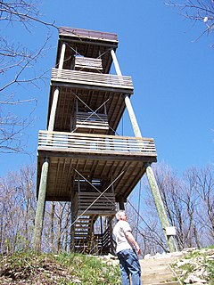
WChippewa Moraine State Recreation Area is a state park unit of Wisconsin, USA, preserving numerous glacial landforms. The abundance and quality of these geological features led to its being included in the Ice Age National Scientific Reserve. The Ice Age National Scenic Trail passes through the park. The park is largely undeveloped, but its modern visitor center serves to interpret the area's geological and biological features. Official documentation alternatively refers to the park as the Chippewa Moraine Ice Age Reserve or the Chippewa Moraine Ice Age National Scientific Reserve. It is located in northwestern Chippewa County.
 W
WDevil's Lake State Park is a state park located in the Baraboo Range in eastern Sauk County, just south of Baraboo, Wisconsin. It is around thirty-five miles northwest of Madison, and is on the western edge of the last ice-sheet deposited during the Wisconsin glaciation. The state park encompasses 9,217 acres (3,730 ha), making it the largest in Wisconsin. The state park is known for its 500-foot-high (150 m) quartzite bluffs along the 360-acre (150 ha) Devil's Lake, which was created by a glacier depositing terminal moraines that plugged the north and south ends of the gap in the bluffs during the last ice age approximately 12,000 years ago. The sand at the bottom of Devil's Lake is thought to be deposited by glaciers.
 W
WHoricon Marsh is a marsh located in northern Dodge and southern Fond du Lac counties of Wisconsin. It is the site of both a national and a state wildlife refuge. The silted-up glacial lake is the largest freshwater cattail marsh in the United States.
 W
WInterstate Park comprises two adjacent state parks on the Minnesota–Wisconsin border, both named Interstate State Park. They straddle the Dalles of the St. Croix River, a deep basalt gorge with glacial potholes and other rock formations. The Wisconsin park is 1,330 acres (538 ha) and the Minnesota park is 298 acres (121 ha). The towns of Taylors Falls, Minnesota and St. Croix Falls, Wisconsin are adjacent to the park. Interstate Park is within the Saint Croix National Scenic Riverway and the Ice Age National Scientific Reserve. The western terminus of the Ice Age National Scenic Trail is on the Wisconsin side. On the Minnesota side, two areas contain National Park Service rustic style buildings and structures that are listed on the National Register of Historic Places.
 W
WThe Kettle Moraine State Forest is a state forest in southeastern Wisconsin. The chief feature of the reserve is the Kettle Moraine, a highly glaciated area. The area contains very hilly terrain and glacial landforms, such as kettles, kames and eskers. The 56,000-acre (23,000 ha) forest is divided into two large and three small units, which are spread across a hundred miles.
 W
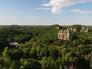
WMill Bluff State Park is a state park in west-central Wisconsin, United States. It is located in eastern Monroe and western Juneau counties, near the village of Camp Douglas. A unit of the Ice Age National Scientific Reserve, the park protects several prominent sandstone bluffs 80 feet (24 m) to 200 feet (61 m) high that formed as sea stacks 12,000 years ago in Glacial Lake Wisconsin. As a result, these bluffs are steep and angular, dissimilar to the rounded terrain more typical of the eastern half of the United States. The bluffs served as landmarks to both early pioneers and travelers today on Interstate 90/94, which passes through the park.
 W
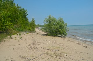
WTwo Creeks Buried Forest State Natural Area is a site in the Wisconsin State Natural Areas Program and a unit of the Ice Age National Scientific Reserve. The site lies in the northeast corner of Manitowoc County on the shore of Lake Michigan north of Two Creeks, Wisconsin, USA. Exposed on the steep lakeshore is a stratum of floral remains embedded in sediment, which is sandwiched between layers of glacial till. The logs, branches, pine needles, pinecones, moss, and other forest litter have been radiocarbon dated to 11,850 years B.P. This is an important site in geochronology because it firmly establishes the timeframe of advances and retreats during the last glacial period.